| GISdevelopment.net ---> AARS ---> ACRS 1999 ---> Measurement and Modeling |
Fully Digital Photogrammetric
Techniques From Imagery to Digital Earth
Deren Li Xiuxiao Yuan
Jianqing Zhang Jianya Gong
Wuhan Technical University of Surveying and Mapping
129 Luoyu Road, Wuhan 430079, P.R. CHINA
Keywords: GPS, GIS, Fully digital
photogrammetry (FDP), GPS-supported aerotriangulation, Geospatial data
framework (GSDF), Digital orthoimage map (DOM), Digital line graph (DLG),
Kinematic GPS positioningWuhan Technical University of Surveying and Mapping
129 Luoyu Road, Wuhan 430079, P.R. CHINA
Abstract
In this information era, the conventional work mode of aerial photogrammetry does not meet the requirement for acquisition of the geographic spatial information. It is important and urgent to study a new methodology requiring high resolution, low production costs, short processing period, and reliability. At present, GPS-supported aerotriangulation can economically determine object points. FDP is able to generate DEM and DOM in the shortest time. GIS can build and manage the image and attribute database. If the above techniques are properly integrated, an new photogrammetric technique obtaining fast GSDF data from image will be established. In this paper, we describes briefly three softwares WuCAPSGPS for GPS-supported aero-triangulation, VirtuoZo for fully digital mapping system and GeoStar for GIS developed by Wuhan Technical University of Surveying and Mapping (WTUSM). We also present the technical path and the central techniques for the integration of the above three softwares. At the end of the present work, a set of empirical results building China GSDF by our integrated system is discussed.
Introduction
With the dramatic development of computer and information technology, we have stepped into the information era. The aerial photogrammetry can supply people the geospatial information which is essential for human being’s activities. The traditional photogrammetry is comprised of comprehensive, time-consuming procedures: 1) aerial photography in the first year, 2) field measurement of GCP (ground control points) and photo annotation next year, and 3) in the third year, cartographic mapping by photogrammetry and hard copy printing. This, however, beats the requirements for the sustainable development of our community to keep up. Therefore, it is important and urgent to find a series of techniques, which can economically supply the generic and thematic information via the Earth observation with quasi real-time processing.
The establishment of such innovative techniques requires the principles containing high resolution, low production costs, short processing time period and reliability. At present, the relevant techniques have considerable developments: photographic frame camera with image motion compensation is able to obtain 100lp/mm optical images; digital high resolution images can be acquired by using image scanners which are available in markets; the techniques such as image matching, feature extraction, pattern recognition, etc. are satisfied for geometric and semantic information extraction with the speed of 1000 points/second; and carrier phase differential GPS positioning can reduce the most workload of ground control measurement, which saves almost a year’s workload; therefore makes the mapping period much shorter; and cuts production costs.
Furthermore, in the era of information exploration, information system turns out to be the mandatory method for the aided decision making in a variety of management. GIS, a new technology in photogrammetry, has also been used in every field for the national economy and the people’s livelihood. GIS as the media for the spatial generic information about the Earth requires prompt, efficient acquisition and updating of its source data. As a result, photogrammetric approaches must be applied, which include fast DEM and DOM generation through the usage of fully digital and automatic methods on the platform of digital photogrammetric systems. A variety of thematic elements are then automatically or interactively extracted from the DOM. The thematic elements are inputted into the GIS database in order to achieve the automatic establishment and updating of GIS databases. This forms China GSDF.
The work procedure described above deals with a series of complex techniques: object point positioning for mapping control by using the GPS-supported automatic aerotriangulation; DEM and DOM generation through the usage of fully digital mapping technology; establishment and management of image and attribute databases via GIS platforms. To date, such a completely integrated system has not been reported worldwidely. Since 1997, sponsored by National 863 Hi-tech Projects, WTUSM has been issued a grant “Integration of the Application-Oriented Softwares for Airborne Earth Observation”. The objectives of the grant are the integration investigation of some systems and techniques developed by WTUSM within the past ten years. The systems contain the GPS-supported aerotriangulation software WuCAPSGPS , fully digital mapping software VirtuoZo, and GIS software GeoStar. The integration is expected to supply practical, usable software and work method, which must achieve a complete production procedure within a short time from aerial photography to the processed results for spatial databases. This has nowadays been achieved. This paper will detail the work flow and the central techniques for FDP, and the technical path for integrating FDP with GPS and GIS in the following sections. The experimental results and technical issues for the establishment of the GSDF in China will be provided.
Work Flow
The usage of fully digital photogrammetric approaches for the establishment of the GSDF actually covers the whole procedure from aerial photography to the completion of all GIS functions. In general, the technical work flow is summarized in Figure 1.
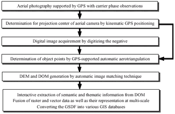
Fig.1 The technical path of integrating FDP with GPS and GIS
The Central Techniques
As shown in Figure 1, FDP actually employs a number of innovative techniques covering GPS, GIS, analytical photogrammetry, digital photogrammetry and so on. The key issues, however, come from the follows:
- Kinematic GPS positioning is introduced into aerial photogrammetry. While aerial photography, GPS signal receivers should work cooperatively with aerial camera; after flight, relative kinematic GPS positioning based on carrier phase observations is used to solve the 3D coordinates of the camera positions. Especially, it is of importance to handle GPS signal cycle slip using ambiguity resolution OTF (On The Fly) strategy. This strategy is able to promptly, efficiently solve the correct ambiguity for the distance of 50km or far, height difference of 2400m or larger. The interior accuracy better than 1dm for the differential GPS positioning can be achieved by fixing the ambiguity.
- Automatic point transfer and image mensuration are fulfilled by an image matching technique which contains local multi-point relaxation algorithm via epipolar geometric constraint. In order to reduce the number of GCP and the workload of the manual measurement in images, the determination of control points in the absolute orientation employs GPS-supported automatic aerotriangulation.
- Road extraction from imagery is semi-automatically achieved. In the road extraction, some techniques are applied. The techniques take into accounts of template matching, approximate point given along roads, candidate determination by template matching in terms of road gray characteristics, geometric constraints regarding road smoothing and continuity, piecewise fitting, and model optimization by Hopefield neural network.
- Automatic house location is realized. In the house location, a house corner is roughly clicked, then two straight lines and the corner are fitted by least-squares method after edge detection and line grouping by Hough transformation. Sequentially, semi-automatic mensuration follows via two phases: the maintenance of an object window covering house roofs as many as possible and automatic house corner matching. Eventually, a 3D city landscape is reconstructed with real surface texture of buildings.
- 2.5D spatial analysis, query and dynamic transfer is achieved through the following steps: DOM generation by digital photogrammetric system VirtuoZo; graphic data converted into GIS database without lose of any information; and establishment of large region image database and its overlay with DEM. A good example is in Guangzhou, where DEM database and DOM database were created by employing GeoStar. The 200 mapsheets of DEM and DOM were however produced by VirtuoZo.
The GPS-supported fully digital photogrammetric system can promptly produce DOM, DEM and DLG. These digital products with the unit of mapsheet need to integrate a complete spatial database under the GIS environment. However, it is not the previous topographic map with primary graphic elements. Therefore President Clinton of the USA proposed National Spatial Data Infrastructure (NSDI) in 1994 and then the integration of a variety of generic data is called GSDF.
According to the national needs and very fast updating, GSDF should include DOM, DEM and several layers of DLG data. Within DLG vector graphic data, at least the following are required:
- Geodetic control network
- Boundaries of administration regions
- Transportation network
- Waterbody
- Geographical names and relative lettering and other necessary information acquired from DOM by operators or users.
- Conduct check, roam and query within the entire spatial database
- Be capable of cover vector graphic data onto image data and update (modify, add and delete, etc.) graphic data using image data
- Is able to realize self-adaptive and multi-resolution display based on image pyramid, ie. image data can be automatically read from the corresponding layer according to the selected display scale
- Achieve image and DEM’s fundamental functions such as 2.5D display, query and roam, etc.
- Can convert all spatial data to other information systems supported by GIS hardwares and softwares in terms of user’s requirements
- Output visualization products with mapsheet or the given range, in terms of user’s needs
Experiments and Applications
WTUSM has produced the production line from imagery to GSDF by applying the above self-developed softwares. Through the mandatory testing and checking, the integration system of FDP, GPS and GIS has been widely applied in many production departments in China.
Up to date, the software of GPS-supported aero- triangulation has been installed more than ten big production departments and teams in China, while more than one hundred copies of VirtuoZo NT has been worldwidely sold. The users of GeoStar are over three hundreds, among which GeoTin producing DEM ever sold sixty copies within one month; map scanner software GeoScan sold over five hundreds of copies. The whole integration system has been equipped in the department of land of Guangdong province and used for provincial spatial data infrastructure.
Shown in Figure 2 is the interface of the WuCAPGPS NT version which is the GPS-supported aerotriangulation software. Its empirical outcomes are indicated in Table 1. The results with the automatic measurement of image coordinates have better accuracy than manual measurement. The digital photogrammetric system VirzuoZo NT version is displayed in Figure 3, while its produced DOM and 3D landscape (originally color map) integrated with DEM are shown in Figure 4. Figure 5 shows the interface of GeoStar NT version, whose product ‘raster-vector unity spatial database’ (originally, the overlay of color graph and image) is partially displayed in Figure 6. This database will have 1000 GB data after completion and will be of great value for applications.
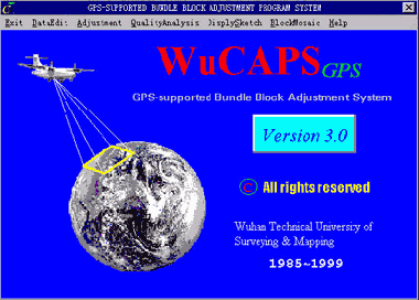
Fig. 2 GPS-supported aerotriangulation software WuCAPSGPS
Tab.1 Results for GPS-supported aerotriangulation
| Ground control points | Mensuration of image points | s0(mm) | Theoretical accuracy (m) | Number of check points | Practical accuracy (m) | ||||
| X | Y | Z | X | Y | Z | ||||
| without GCP | manually | 14.8 | 0.332 | 0.448 | 0.491 | 6 | 0.239 | 0.313 | 0.351 |
| automatically | 12.5 | 2.728 | 2.126 | 1.082 | 2.383 | 1.825 | 1.077 | ||
| with 4 corner points | manually | 14.3 | 0.174 | 0.217 | 0.343 | 2 | 0.122 | 0.491 | 0.268 |
| automatically | 12.2 | 0.127 | 0.147 | 0.253 | 0.350 | 0.331 | 0.196 | ||
Remarks: 1.The automatic mensuration of image points is accomplished by VirtuoZo NT. The scanning resolution of digitizing the aerial negative is 25mm.
2.S0 is the root square mean error of the measurement of image points. Theoretical accuracy is the root square mean error of unknowns obtained by the formula
 is the variance-covariance matrix of
unknowns;
is the variance-covariance matrix of
unknowns; Practical accuracy is the root square mean error for the coordinates of photogrammetric points calculated by the formula
 are the coordinate residuals of the
ground check points.
are the coordinate residuals of the
ground check points.
Fig.3 Digital photogrammetric workstation VirtuoZo NT
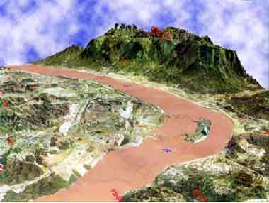
Fig.4 3D landscape generating by VirtuoZo NT (originally color map)
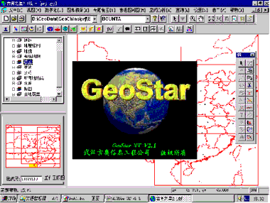
Fig.5 Object oriented GIS software GeoStar
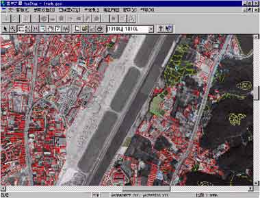
Fig. 6 Raster-vector unity GSDF managing by GeoStar (originally color map)
Conclusions
The integration of FDP, GPS and GIS is the mandatory path of the progress of photogrammetry. WTUSM has developed an entire set of software and work flow from aerial photography to GIS spatial database. This integrated software has been used for a model project of the provincial fundamental GIS system in Guangzhou and is being broadly extended to production within the department of surveying and mapping in China. This system will definitively supply techniques and softwares into any level of GSDF and open a path for Digital Earth.
Acknowledgments
The authors would like to explicitly thank Dr. Juliang Shao for his polishing in English. This project is sponsored by Development Foundation of Surveying and Mapping, China National 863 Hi-tech Projects (No. 863-308-13-04(2)).
References
- Chen Xiaoming, 1997. Research on the Theory and Practice of High Precision GPS Kinematic Positioning, Dissertation, WTUSM.
- Yuan Xiuxiao, 1999. GPS-supported Aerotriangulation and its Quality Control Means, Dissertation, WTUSM.
- Li Deren, et al, 1997. GPS-supported Fully Automatic Aerotriangulation, Journal of Remote Sensing, 1(4), pp.306~310.
- Zhang Jianqing, et al, 1998. Reconstruction of 3D Landscape from Image with Large Scale for Urban Region, Journal of WTUSM, 23(4), pp.355~358.
- Li Deren, et al, 1998. Design and Implementation of Digital Geospatial Data Framework in China, Journal of WTUSM, 23(4), pp.297~303.