| GISdevelopment.net ---> AARS ---> ACRS 1999 ---> Land Use |
Landuse Change and Urban
Growing Monitoring in China
Prof. Li yingcheng, Chu
liangcai, Guo tongying, Xue Yanli, Li xueyou, Ding xiaobo, Liu xiaolong
Chinese Academy of surveying & Mappping ,Beijing,P.R.China
Email: casmphrs@public3.bta.net.cn
Chinese Academy of surveying & Mappping ,Beijing,P.R.China
Email: casmphrs@public3.bta.net.cn
Keyword: landuse change and urban growing, RS
monitoring
Abstract
To effectively protect the agriculture land, the department responsible for the land resource management of China organize the landuse change and urban growing monitoring project using remote sensing technique in 100 cities during the recent 3 years.
The paper describes the landuse change and urban growing monitoring project in Henan province. The landuse change classification system, the technological process, the technical methods and data management are presented. Especially the multi-resource data fusion technique, the change detection technique and landuse change mapping technique are describe in detail.
It looks clear that the remote sensing monitoring is helpful for the land resource management. It can objectively provide the quantity and location of landuse change information, and also can assist to enforce the land law.
1. agriculture land problem in China
In China, with large number of population and less agriculture land, the average area of agriculture land is only 47% of the world average level, and there are about 666 counties whose average area are lower than 0.8 acre--- the lowest alarm level formulated by the World Food and Agriculture Organization. More than, with the development of economy, the growing of urban and rural occupy a large number of agriculture land, followed by the effect of arid, pollution, salinization and desertization, the agriculture land continue to decrease, the amount is high to 7000,000 acre every year.
The agriculture land is the main source of the food and closely relates with people’s lives. President Jiang once emphasis repeatedly: “Protect agriculture land is equal to protect our life line ”. How to control the land decreasing and protect the land is very important. But the development of economy must be ensured at the same time of protection. So how to protect the land, and coincide the contradiction between development & protection require that the administrators are full clear with the status of the agriculture land and the landuse change in our country, especially the real status of urban growing. Only based on accurate numbers, there will be drawn up science measures.
For many years, the National Land Bureau relies on the landuse map, landuse detail investigation materials and landuse change materials that are supplied by the local land administrators. Some problems exist within them, first, the period of acquiring is too long which can not be satisfied with the necessary of the economy development; the second, some of the data that supplied by local land administrators may be fault for their local benefits. So, the new measures and technique must be taken. It’s the Remote Sensing technology (RS). RS can reflect the true image of land and supply the real information of landuse and change without any disturbance of person, more than, it is good at high speed and short period, and can supply data as soon as possible.
2. the development and focus of landuse change and urban growing monitoring
2.1 the history and status quo of landuse change and urban growing monitoring in China
Since the Eighth-five years, the National Land Bureau begin to do work for the RS monitoring. From Aug.1996 to Mar.1997, they organize to finish 17 cities RS monitoring with three period TM data; In 1997, 100 cities RS monitoring are completed with 91 and 97 TM data; By the end of 1998, RS monitoring is done in Zhengzhou, Taiyuan, Luoyang and other important cities. This series of experiments truly reflect the reality of landuse change and urban growing, and give assistance to the land administrators; except that, the perfect technique route and rich experiences are accumulated in the works.
In 1998, the National Resource Department formulate the measure of “the rule of landuse dynamic Remote Sensing monitoring”, which will be the basis for the RS Monitoring in the future. In 1999, the National Resource Department plan to do RS Monitoring of 69 cities including 30 provincial capitals, 5 municipalities directly under the Central Government and others important cities in order to cooperate with the investigation of the national resources. According to the reality of China, four types of RS Monitoring period are adopted: municipalities, developed cities and important cities in eastern China do every year; important agriculture zones do every three years; hills, grassland and forest do every five years; the desert zones in western China do every ten years or more.
2.2 the focus and aim of landuse change and urban growing monitoring
The focus of landuse change and urban growing monitoring is to monitor the occupy of the agriculture land. In China, the important monitoring objects will include all provincial capitals, developed cities in the eastern and others important cities. In these cities, zones between the urban and rural, important economic development zones and commercial zones, the sides of important country roads, the large and middle construction objects licensed by government will be the focus in the monitoring.
RS monitoring is the means with high speed, accurate and efficiency, it not only gives the amount and location of the change information of landuse, but also can be used to check the data supplied by local government. It gives the administrators with scientific assistance in the macro managing, planning and utilizing the land resource. It is also an important means in constructing the system of national landuse dynamic monitoring.
3. technical route and key technique of landuse change and urban growing monitoring
The data sources for landuse change and urban growing monitoring including the SPOT pan&multi-spectrum data, TM multi-spectrum data, IRS-1C data, SAR data and other high resolution RS data. Monitoring Zone are often used in the works of landuse change and urban growing monitoring. The choice of suitable monitoring zone not only helps to reduce work amount, but also improve the precise of change information. The county administrative area is often used as the monitoring zone.
In order to keep consistent with the means and data of existing country landuse investigation, A classification system of RS monitoring are made refer to the classification system of country landuse status investigation. It including: Agriculture land: cultivated land, forest, garden, grassland, river, lake, reservoir and pool, etc;
Construct land: residence, industry, mineral land, transport land, gorge and channel, buildings over the water;
Unutilized land: Unutilized land, beachhead, reed land, iceberg, permanent snow;
uncultivated land: the land without plants temporary;
Unused Construct land;
This classification system is the basis to interpret and classify the RS data. The common methods of classification include interpretation with eyes, supervise classifying, unsupervise classifying and others.
The technique route of RS monitoring will be introduced in the context, which is drawn up from experiments.
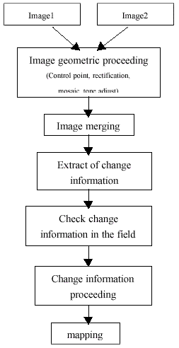
3.1 image geometric proceeding
Image geometric proceeding is to proceed multi-sources data with such steps as the choice of control point, image rectification, image mosaic and image tone adjust, etc. In the end, multi-sources data will be integrated to the same coordinate system and the same image resolution, prepared for the image merging, image cover and change information extraction.
The control point materials can be the control points from fieldwork, or densification points, or points directly got from the map. The means of point choice can be the image referring to the map, or the image referring to the image. The models of rectification include geometric polynomial rectification, or digital differential rectification. Geometric polynomial rectification suits for the terrain, and digital differential rectification for hills and mountains or the SPOT data with large inclination angle.
3.2 image merging
RS data qualified with the characters of multi-spectrums, multi-spatial resolutions and multi-sensors. In order to utilize the advantages of these multi-sources RS data, merging technique is used to acquire the high resolution of SPOT data (or similar data) and the multi-spectrum of TM data (or similar data). The merging data have higher interpreting precise. Before merging, what must be done is to improve the characters of each image separately. The color spatial transform (IHS), K.L. transform and wave let transform are the normal merging methods.
3.3 extract of change information
Change information refers to the change of feature object in the location, range and types during a period. It can be classified to several types according to “the rule of landuse dynamic remote sensing monitoring”:
New urban, rural residence, isolate industry and mineral building occupy the cultivated land ;
New urban, rural residence, isolate industry and mineral building occupy the non-cultivated land;
New railways, roads, airports and other building occupy the cultivated land;
New railways, roads, airports and other building occupy the non-cultivated land ;
The cultivated land transferred into water and other non-construct land ;
New cultivated land;
Uncultivated land ;
Unused Construct land;
The means of extracting change information from image include the subtract of image, Principal Components Analysis, the subtract of vegetation index, classification comparing, the comparing between classification results and maps, etc.
3.4 check change information in the field
It is difficult to interpret the object types and change in the images without error, because the spectrum of surface features is very complex: the same object maybe own different spectrum in the different periods and with wave channels, different object maybe have the same spectrum in some wave channels. So some interpretation results maybe are error. In order to discard error and get accurate results, investigation in the fieldwork is very necessary. Before investigation, the change information must be coded, then the types, range and location of the objects are determined one by one in the fieldwork.
3.5 change information proceeding After the investigation in the fieldwork, what must be done is to rectify the location, range and types of change information, then calculate their areas.
3.6 Mapping
In order to describe the information at the best and supply maps, The mapping for landuse change dynamic monitoring is needed. The content of mapping include rectified images, merging images, county boundary or higher level boundary, planning zone boundary, kilometer grid, location names, change information and the codes. These contents are arranged together by covers.
4 examples analysis of landuse change and urban growing monitoring
In recent years, our group completed several RS monitoring projects, such as landuse change and urban growing monitoring of Henan Province (1991- 1997), landuse change and urban growing monitoring of Zhenzhou city, Luoyang city(1997-1998), landuse change and urban growing monitoring of Xi’an city, Wuhan city(1998-1999), landuse change and urban growing monitoring of Beijing(1998-1999).They are finished with the base technical route in the context, but because of the different of data sources , the detail steps of every project are adjusted.
4.1 landuse change and urban growing monitoring of Henan Province (1991-1997)
From 1997 to 1998, our group undertakes the project of landuse change and urban growing monitoring of Henan Province. This project have 24 scenes TM images (12 scenes of 1991, 12 of 1997). Considering the duration between 1991 and 1997 is long, the technical program is determined to classify the TM images separately, and then extract the change between 1991 and 1997.
In this project, rectification and classifying are done with the images of 1991 and 1997 separately, the landuse data (sum up to 9 types such as agriculture land, non-agriculture land and unutilized land) are acquired, the urban and rural growing are the focus. No more than five months, this project is completed, 55 sheet maps including classification maps and change information maps of 18 cities in Henan province, the statistics data and charts are supplied, except that, the landuse change dynamic RS monitoring system of Henan Province is set up.
4.2 landuse change and urban growing monitoring of Beijing(1998-1999)
Sept 1999, group completed the landuse change and urban growing monitoring of Beijing. There are four scenes SPOT pan-data of 1996, three scenes SPOT pan-data of 1999, each scene TM5 multi-spectrum data of 1997 and 1999. In order to utilized the high resolution character of SPOT data and the multi-spectrum character of TM data, the merging technology are used to merge the 96 SPOT data with 97 TM data, 99 SPOT with TM. Then K.L. analysis and interpretation with eyes are used to extract the change information. The results include merging images of 97 and 99, change information map and their statistics data.
All of the Projects are finished with the Photomapper Ortho-photo production system which is developed by our group.
Abstract
To effectively protect the agriculture land, the department responsible for the land resource management of China organize the landuse change and urban growing monitoring project using remote sensing technique in 100 cities during the recent 3 years.
The paper describes the landuse change and urban growing monitoring project in Henan province. The landuse change classification system, the technological process, the technical methods and data management are presented. Especially the multi-resource data fusion technique, the change detection technique and landuse change mapping technique are describe in detail.
It looks clear that the remote sensing monitoring is helpful for the land resource management. It can objectively provide the quantity and location of landuse change information, and also can assist to enforce the land law.
1. agriculture land problem in China
In China, with large number of population and less agriculture land, the average area of agriculture land is only 47% of the world average level, and there are about 666 counties whose average area are lower than 0.8 acre--- the lowest alarm level formulated by the World Food and Agriculture Organization. More than, with the development of economy, the growing of urban and rural occupy a large number of agriculture land, followed by the effect of arid, pollution, salinization and desertization, the agriculture land continue to decrease, the amount is high to 7000,000 acre every year.
The agriculture land is the main source of the food and closely relates with people’s lives. President Jiang once emphasis repeatedly: “Protect agriculture land is equal to protect our life line ”. How to control the land decreasing and protect the land is very important. But the development of economy must be ensured at the same time of protection. So how to protect the land, and coincide the contradiction between development & protection require that the administrators are full clear with the status of the agriculture land and the landuse change in our country, especially the real status of urban growing. Only based on accurate numbers, there will be drawn up science measures.
For many years, the National Land Bureau relies on the landuse map, landuse detail investigation materials and landuse change materials that are supplied by the local land administrators. Some problems exist within them, first, the period of acquiring is too long which can not be satisfied with the necessary of the economy development; the second, some of the data that supplied by local land administrators may be fault for their local benefits. So, the new measures and technique must be taken. It’s the Remote Sensing technology (RS). RS can reflect the true image of land and supply the real information of landuse and change without any disturbance of person, more than, it is good at high speed and short period, and can supply data as soon as possible.
2. the development and focus of landuse change and urban growing monitoring
2.1 the history and status quo of landuse change and urban growing monitoring in China
Since the Eighth-five years, the National Land Bureau begin to do work for the RS monitoring. From Aug.1996 to Mar.1997, they organize to finish 17 cities RS monitoring with three period TM data; In 1997, 100 cities RS monitoring are completed with 91 and 97 TM data; By the end of 1998, RS monitoring is done in Zhengzhou, Taiyuan, Luoyang and other important cities. This series of experiments truly reflect the reality of landuse change and urban growing, and give assistance to the land administrators; except that, the perfect technique route and rich experiences are accumulated in the works.
In 1998, the National Resource Department formulate the measure of “the rule of landuse dynamic Remote Sensing monitoring”, which will be the basis for the RS Monitoring in the future. In 1999, the National Resource Department plan to do RS Monitoring of 69 cities including 30 provincial capitals, 5 municipalities directly under the Central Government and others important cities in order to cooperate with the investigation of the national resources. According to the reality of China, four types of RS Monitoring period are adopted: municipalities, developed cities and important cities in eastern China do every year; important agriculture zones do every three years; hills, grassland and forest do every five years; the desert zones in western China do every ten years or more.
2.2 the focus and aim of landuse change and urban growing monitoring
The focus of landuse change and urban growing monitoring is to monitor the occupy of the agriculture land. In China, the important monitoring objects will include all provincial capitals, developed cities in the eastern and others important cities. In these cities, zones between the urban and rural, important economic development zones and commercial zones, the sides of important country roads, the large and middle construction objects licensed by government will be the focus in the monitoring.
RS monitoring is the means with high speed, accurate and efficiency, it not only gives the amount and location of the change information of landuse, but also can be used to check the data supplied by local government. It gives the administrators with scientific assistance in the macro managing, planning and utilizing the land resource. It is also an important means in constructing the system of national landuse dynamic monitoring.
3. technical route and key technique of landuse change and urban growing monitoring
The data sources for landuse change and urban growing monitoring including the SPOT pan&multi-spectrum data, TM multi-spectrum data, IRS-1C data, SAR data and other high resolution RS data. Monitoring Zone are often used in the works of landuse change and urban growing monitoring. The choice of suitable monitoring zone not only helps to reduce work amount, but also improve the precise of change information. The county administrative area is often used as the monitoring zone.
In order to keep consistent with the means and data of existing country landuse investigation, A classification system of RS monitoring are made refer to the classification system of country landuse status investigation. It including: Agriculture land: cultivated land, forest, garden, grassland, river, lake, reservoir and pool, etc;
Construct land: residence, industry, mineral land, transport land, gorge and channel, buildings over the water;
Unutilized land: Unutilized land, beachhead, reed land, iceberg, permanent snow;
uncultivated land: the land without plants temporary;
Unused Construct land;
This classification system is the basis to interpret and classify the RS data. The common methods of classification include interpretation with eyes, supervise classifying, unsupervise classifying and others.
The technique route of RS monitoring will be introduced in the context, which is drawn up from experiments.
3.1 image geometric proceeding
Image geometric proceeding is to proceed multi-sources data with such steps as the choice of control point, image rectification, image mosaic and image tone adjust, etc. In the end, multi-sources data will be integrated to the same coordinate system and the same image resolution, prepared for the image merging, image cover and change information extraction.
The control point materials can be the control points from fieldwork, or densification points, or points directly got from the map. The means of point choice can be the image referring to the map, or the image referring to the image. The models of rectification include geometric polynomial rectification, or digital differential rectification. Geometric polynomial rectification suits for the terrain, and digital differential rectification for hills and mountains or the SPOT data with large inclination angle.
3.2 image merging
RS data qualified with the characters of multi-spectrums, multi-spatial resolutions and multi-sensors. In order to utilize the advantages of these multi-sources RS data, merging technique is used to acquire the high resolution of SPOT data (or similar data) and the multi-spectrum of TM data (or similar data). The merging data have higher interpreting precise. Before merging, what must be done is to improve the characters of each image separately. The color spatial transform (IHS), K.L. transform and wave let transform are the normal merging methods.
3.3 extract of change information
Change information refers to the change of feature object in the location, range and types during a period. It can be classified to several types according to “the rule of landuse dynamic remote sensing monitoring”:
New urban, rural residence, isolate industry and mineral building occupy the cultivated land ;
New urban, rural residence, isolate industry and mineral building occupy the non-cultivated land;
New railways, roads, airports and other building occupy the cultivated land;
New railways, roads, airports and other building occupy the non-cultivated land ;
The cultivated land transferred into water and other non-construct land ;
New cultivated land;
Uncultivated land ;
Unused Construct land;
The means of extracting change information from image include the subtract of image, Principal Components Analysis, the subtract of vegetation index, classification comparing, the comparing between classification results and maps, etc.
3.4 check change information in the field
It is difficult to interpret the object types and change in the images without error, because the spectrum of surface features is very complex: the same object maybe own different spectrum in the different periods and with wave channels, different object maybe have the same spectrum in some wave channels. So some interpretation results maybe are error. In order to discard error and get accurate results, investigation in the fieldwork is very necessary. Before investigation, the change information must be coded, then the types, range and location of the objects are determined one by one in the fieldwork.
3.5 change information proceeding After the investigation in the fieldwork, what must be done is to rectify the location, range and types of change information, then calculate their areas.
3.6 Mapping
In order to describe the information at the best and supply maps, The mapping for landuse change dynamic monitoring is needed. The content of mapping include rectified images, merging images, county boundary or higher level boundary, planning zone boundary, kilometer grid, location names, change information and the codes. These contents are arranged together by covers.
4 examples analysis of landuse change and urban growing monitoring
In recent years, our group completed several RS monitoring projects, such as landuse change and urban growing monitoring of Henan Province (1991- 1997), landuse change and urban growing monitoring of Zhenzhou city, Luoyang city(1997-1998), landuse change and urban growing monitoring of Xi’an city, Wuhan city(1998-1999), landuse change and urban growing monitoring of Beijing(1998-1999).They are finished with the base technical route in the context, but because of the different of data sources , the detail steps of every project are adjusted.
4.1 landuse change and urban growing monitoring of Henan Province (1991-1997)
From 1997 to 1998, our group undertakes the project of landuse change and urban growing monitoring of Henan Province. This project have 24 scenes TM images (12 scenes of 1991, 12 of 1997). Considering the duration between 1991 and 1997 is long, the technical program is determined to classify the TM images separately, and then extract the change between 1991 and 1997.
In this project, rectification and classifying are done with the images of 1991 and 1997 separately, the landuse data (sum up to 9 types such as agriculture land, non-agriculture land and unutilized land) are acquired, the urban and rural growing are the focus. No more than five months, this project is completed, 55 sheet maps including classification maps and change information maps of 18 cities in Henan province, the statistics data and charts are supplied, except that, the landuse change dynamic RS monitoring system of Henan Province is set up.
4.2 landuse change and urban growing monitoring of Beijing(1998-1999)
Sept 1999, group completed the landuse change and urban growing monitoring of Beijing. There are four scenes SPOT pan-data of 1996, three scenes SPOT pan-data of 1999, each scene TM5 multi-spectrum data of 1997 and 1999. In order to utilized the high resolution character of SPOT data and the multi-spectrum character of TM data, the merging technology are used to merge the 96 SPOT data with 97 TM data, 99 SPOT with TM. Then K.L. analysis and interpretation with eyes are used to extract the change information. The results include merging images of 97 and 99, change information map and their statistics data.
All of the Projects are finished with the Photomapper Ortho-photo production system which is developed by our group.