| GISdevelopment.net ---> AARS ---> ACRS 1999 ---> Land Use |
Land Use/Land Cover Mapping
of Central Water Shed of Iran Area Based on Satellite Data Interpretation
K. Ahmadi
Soroush
Iranian Remote Sensing Center Tehran, Iran.
Abstract Iranian Remote Sensing Center Tehran, Iran.
An area of 92125 sqkm located in North-West part of Iranian Central plateau, which is a sub- badip of Iranian Internal Water- shed, was selected for this Investigation.
The main objective of this investigation were construction of
- Land use map and land cover map
- Measuring of the area cover aqe in all units.
In the land use map, several major units such as; Agricultural lands, forest lands, Range lands , Water resources and urban area have been recognized.
Results obtained in this investigation indicate Landsat inquiry could be used for land use and cover mapping in an area and undoubtedly could be considered as a essential tool in our country.
Introduction
There is no doubt that in a country such as Iran. In which large portions of the country fall under the categories of "arid" and "semiarid" land; the capability of mapping land use/land cover is important.
Acknowledge of land use and land cover is important for many planning and management activities concerned with the surface of the earth.
The primary objective of these investigation are to demonstrate the applications are to demonstrate the application of land set data for application of land sat data for organization with information which will assist in resource planning, development and better utilization through management wait5hin Iran.
This report out lines a visual interpretation approach for interpreting and mapping qenera land sat images.
Methodology
In undertaking this study the following steps were performed:
- Data collection-utilization of all available Landsat inquery of this study area dates, literature review.
- Data interpretation Ladnd use / land cover classification of the central watershed, based on visual analysis and interpretation of available land-sat dates.
- Mapping Landuse/land cover-various landuse/land cover recoqvized and their distribution is shown in the innduse/land cover "map of centeral watershed which is exhibited
The study area occupies about 92125 sq. km.
This basin in cludes 6 sub-basin terminating the namak lake, they are called open or closed sub- basin is called Arak.
The most important cities in this study area are: Tehran, Hamedan , Gazvin, Kashan, ,Arak.
The mountainous regions surrounding this watershed ,in higher elevation is14929fin north and lower portion is ab -out 3117 f near Namak Lake.
Climate
Considerable variations in climate can be seen in central watershed .the differences are primarily a result of topography and can generally be expressed in terms of amount of precipitation and length of growing season , Three zones, have been designated for thes stuffy area utilizing a modified koppen system. These zones area-arid, semiarid, moderate.
Precipitation in the region is relatively low as the principal storms that originate in the Mediterranean lose a major portion of their moisture on rising over the Alborz or Zagros ranges. The average annual precipitation for stations in the central region ranges between 350 and 100 millimeters.
Relative humidity varies widely in the region depending on wind, precipitation and altitude.
Water Resources
The water resources of the central watershed are presented in terms of surface water availability and ground water availability Surface water availan9lity the main natural drainage of the basin consist of the Jajrud, Karaj-rud, Ghareh chai, Khar-rud, Ghom-rud that Lerminatr in the Namak Lakes in this region have potential to continue to surface water development, the effect of artificial storage reservoirs will be considered in the supply demand comparisons.
The surface water analysis shows that the water of most rivers in this region can be used for agricultural and industrial purposes and also for municipal use.
Ground water availability- this presentation is largely concerned with the ground water availability of the plains of valliry alluvium of this region the ground water of this area consists of the shallow and deep wells are most important an arid and semiarid area of this watershed, as main source for water.
Geology
By inspection the Tec tomes-map of Iran indicates that the central watershed is composed of the three geological groups: igneous metamorphic and sedimentary.
Most of the region is covered by sedimentary deposits, conglomerates and evaporates of the central Iranian Depression. These deposits are overlaid by volcanic rocks and tuffs .
The area where the Zagros mountain ranges surrounds the inner plateau is generally described as sedimentary , with slight met am orphism.
A small area north-east of Golpayegan also displays metamorphism. The marked salinity within the region results primarily because the evaporation potential exceeds precipitation. This is evidenced by the runoff that flows into the inland basins. The flows subsequently evaporate, leaving a residue of salt concentrates. In addition a number of salt plugs increase the salinity of the natural runoff.
Results and Analysis
Landuse/land cover map of the central watershed which is exhibited at a scale of 1:1000,000,based on visual analysis and interpretation of available Landsat data .
In this area, seven major units have been recognized as follows:
- Urban or built-up lands:
This unit consists of residential, industrial, commercial area and major transportation and communication. - Agricultural lands: This area consists of predominantly irrigated croplands, Dry farm croplands, Orchard, Vine Yards that occur predominantly in plains, around the residential area., along the rivers, gently slop in hills.
- Range lands:
This area consists of high, medium, low, poor production rangelands that mainly occurring on the mountains, hills and plains, - Forest lands: There is low density forest in this wate4rshed because of at low rain fall.
- water
This unit consists of the main natural drainage and four reservoirs. - Wel lands:
This area cover by permanent and temporary salt water that consists of shruns and nonshrubs wet lands. Mainly occurring in the lowland areas. - Barren lands:
Most of this area located on arid parts of watershed. It consists of salt flats and playas, sandy area, bare exposed rock.
The following conclusions and recommendation obtained from results and analysis :
- To achieve accurate and desirable results, the interpreters should nesting site well informed about the general geography conditions of the area and also be familiar with existing land form.
- There should be logical relation between level of study and the chosen scale.
- Using of imagery prepared in spring and autumn is more suitable for landuse/land cover mapping, but using imagery prepared at different times of the year could nesting site use full in interpretation of data.
- Its better that the selected images should have uniform colour tone as well as good quality so that following land-use units from one image to another is smooth.
- The accuracy interpretation for the several be about equal.
- Utilization of all available data and field control is important for interpretation and accuracy for landuse/ land cover mapping.
- Available and standardize classification system according to the natural characteristic of the country is necessary.
| No | Unit | Area of Coverage(Square Kms.) | Percentage |
| 1 2 3 4 5 6 |
Urban of built-up lands Agricultural lands Range lands Forest lands Wet lands Barren lands |
540.6 25518.2 48473 71.4 6399.7 11122.1 |
0.59 27.69 52.61 0.08 6.95 12.08 |
| Total | 92125.0 | 100.0 | |
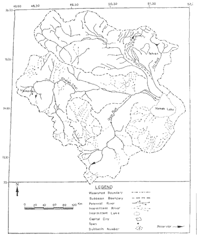
Figure 1: Darinags and sub-basin map of the centeral watershed, base on landsat images.
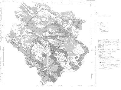
Figure 2: Land use/landcover map of the centeral watershed, base on landsat images.