| GISdevelopment.net ---> AARS ---> ACRS 1999 ---> Land Use |
Model Simulated Land
Use/Cover Changes in Thailand -Results from AGENT-LUC Model
K S Rajan* and Ryosuke
Shibasaki**,
*Institute of Industrial Science, University of Tokyo,
**Center for Spatial Information Science, University of Tokyo,
4-6-1, Komaba, Meguro-Ku, Tokyo 53-8505. (Japan)
Tel: (81)-3-5452-6415 Fax: (81)-3-5452-6410
E-mail: rajan@skl.iis.u-tokyo.ac.jp
*Institute of Industrial Science, University of Tokyo,
**Center for Spatial Information Science, University of Tokyo,
4-6-1, Komaba, Meguro-Ku, Tokyo 53-8505. (Japan)
Tel: (81)-3-5452-6415 Fax: (81)-3-5452-6410
E-mail: rajan@skl.iis.u-tokyo.ac.jp
Keywords: Agent, GIS, Land Use and Land Cover,
Model,
Abstract:
AGENT-LUC, Anthropogenically Engineered Transformation of Land Use and Land Cover Model, is a national scale model, that allows for dynamics time-series simulation and analysis of the changes brought about in the land use by the action of humans within the boundaries of the natural terrestrial earth system. The model deals with the application of the concept of "agent" as the decision-maker in simulating the land use/ land cover changes. The agent decides on the next course of action based on the information available to him from both the worlds of micro and macro-information. The bio-physical characteristics of the land is considered along with its economic condition, given the social apparatus at a given point in time, in arriving at the choice of the land use. The entire process is carried out on a grid-by-grid basis, and is aggregated at the different scales to analyze and the results compared with the prevailing macro-condition. This kind of bottom-up approach with inter-scale aggregations help to develop more realistic scenario of the land use changes. The use of GIS platform and its tools has helped in analyzing the micro-information (spatial) within the boundaries of the available macro-level (non-spatial) data.
1. Introduction
Most of the global physical and biological models that have been developed for the understanding of the various parts of the global earth system, are dependent on the land use and land cover information, as these with their control on the albedo and water & nutrient cycling establish the boundary conditions to these models (Robinson, 1994). Land use/ land cover is continuously changing, both under the influence of humans and nature, resulting in various kinds of impacts on the ecosystem (Rajan, et. al., 1997a). These impacts at local, regional and global levels have the potential to significantly affect the sustainability of the world agricultural systems and the forest systems- the two major human life supporting systems. The most important factor in the modification of the land cover and its conversion is the human use component rather than the natural changes (Turner, et. al., 1993). Changes in the land cover cannot be understood without a better knowledge of the land use changes that drive them and their links to human causes. The linkages between the human and biophysical causes or drivers to land management and land cover are not sufficiently understood (Rajan et. a., 1997b). This arises from the complexity in dealing with the considerable variations in the land use drivers; land use and land cover at the various levels-local, national and regional.
At present, the global models and studies of land use changes capture the broad sectoral trend based on the changes in some of the macro variables, like population, quality of life and technology level. The statistical data shows a strong support in concluding that these variables may be the underlying drivers of environmental changes (Bilsborrow et. al., 1992). On the other hand, such statistical relationship do not hold good for long-term analysis if the trends are dominated more by policy options, like export oriented agricultural production of cassava, and not by the inherent needs of the population, as seen in Fig. 1 , for Thailand. Around 10% of the Cassava produced is consumed domestically, while the rest is mainly for export markets.
Land use can be looked upon as a multi-dimensional (³4D) process, which consequently poses many difficulties for proper description and classification. In the context of global change, the formal characteristics of land use. i.e. its effect on cover structure, phenology and composition, is more relevant than the purpose of function of landuse (Veldkamp et. al., 1996). But, unless the function is properly understood, it is difficult to amalgamate the land use conditions into the processes that drive the changes in land use and land cover. Most of the changes are highly dependent on the biophysical constraints of the land units and the human understandings of these. The model should be able to simulate land use/land cover changes in response to both the biophysical constraints - existing and the changes within, and the socio-economic conditions prevailing at a given point of time. The socio-economic factors like the population, economic, conditions, educational levels etc. are the human drivers that have to be considered in such a model. It is recognized that changes in the scale of analysis, changes the results. As such, it is necessary to consider the feedback effects in such models, as these feedbacks also act as causes or drivers at different scales of analysis and interpretation should be taken into account.
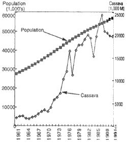
Fig 1 Cassava Production and Population distribution in Thailand for the period 1961 to 1991.
Here, in this paper we describe a new concept that can be used to effectively model the macro-characteristics that describe the landuse along with the known macro-variables that also influence such changes. First, we describe the general concept and principles and issue of the new concept developed by us. Also, its applicability will be discussed within the framework of developing a land use/cover change model at the national level.
2. AGENT-LUC Model
2.1 Concepts and Principles
Land evaluation and suitability has long used the biophysical factors like climate and soil as its determining factors. (FAO, 1978) but the influence of human factors are not so well studies and described. Also, there exists considerable gap between the potential suitability of a given area to its actual productivity. Recent advances in modeling crop-yields based on their phenology have yielded better results, though the majority of them are point/location-specific.
In order to model land use/cover changes under the assumption that its function is influenced by the prevailing economic conditions at a given place and time, it is necessary to evaluate or estimate the scenario that closely resembles reality. The human ability to comprehend and anticipate (with a limited risk) needs to be considered in deriving land use/cover changes. The model proposed here deals with the development and application of a new concept, proposed by the authors, in simulating the land use/cover changes-the presence of an agent as the decision-maker. The agent decides on the next course of action based on the information available to him from both the worlds of macro information. The decision making process takes into consideration the prevailing bio-physical characteristics of the land, the economic condition, and the land use history along with the existing social apparatus in a given year, for arriving at the choice of the annual land use.
Concept of an agent
Here, the term agent refers to an individual or a group of individuals who exist in a given area (referred to as grid) and are capable of making decisions for themselves (or the given area). The agent also acts as an interface in helping to assimilate the broader macro-information into the decision-making process at the grid level, thereby creating an action in response to the natural and economic stimuli.
World of Micro and Macro Information
In this paper, the term 'micro' refers to the data used at the grid level in assessing the supportability of each grid. The crop-specific productivity is calculated at the grid-level, considering the local bio-physical characteristics. The bio-physical attributes considered here, are the climate (temperature, rain and radiation) and soil properties, along with water and nutrient stresses to agricultural productivity.
The 'world of macro' information refers to the data at the sub-national (regional or provincial) or national level. This data is mainly statistical in nature. It is used to compare and adjust the model simulations, to arrive at realistic cause-effect relationship within the model. The macro-data considered are total agricultural demand and supply in a given year, the GNP per capita changes, the contribution of the agricultural and non-agricultural sectors to GNP, and population distributions at the National and sub-national levels.
Additional Information Used
In addition to the above data, the experience of different researchers in arriving at qualitative conclusions on the land use practices in the difference regions of the study area are also considered in charting out the behavioral patterns of the agents.
2.2 Model Description
The overall framework of the model is given below, in Fig. 2. The model consists of four sun-models- the bio-physical crop yield sub-model, the agricultural income sub-model, the urban land use sub-model and the land use decision sub-model. All these four sub-models interact and have feedback loops, to determine the new course of action by the agent at the next time step. The model structure is sequential. The model calculations were carried out on a land unit basis, consisting of 1 km square grids.
The bio-physical crop yield sub-model calculates the potential productivity of the land unit for the given conditions of soil, topography, water availability and climatic parameters. The distribution of water availability takes into account the soil conditions, amount of rain-received, and the existence of irrigation facilities. The main assumption of this sub-model is that these are a strong linkage between the climate and crop distributions. (Leemans, et. al., 1993). The crop yield estimates are derived by modifying the approach described in the EPIC model (EPIC, 1990). The central concept of this approach is the growing period and the photosynthetic efficiency of the crops. The biomass and yield calculations are carried out on a day-to day-basis and the final yield takes into effect the fluctuations in water and nutrient availability.
The agricultural income sub-model estimates the income per land unit from various sources including the yield-related revenue and the cost of production. The model also accounts for the initial cost incurred in land conversion from other uses to agricultural lands. The other incomes considered are the non-yield-on-farm income and the off-farm income. These factors influence the decision making process, in case of fluctuating crop-yield incomes from a given area.
Urban land use is the other major land use that is primarily influenced by the activities of the human beings. Here, we estimate the urban land requirements as its competes with the agricultural areas due to increasing population pressures and the rise in the economic levels of the region. The model takes into account the location value of the land-unit in assessing the new areas that will be urbanized. The model assumes that all the extra land needed for the urban areas in a given year is fulfilled in the next year. The model provides information on the urban land demand and supply, on a spatial basis.
The final step in the simulation is the land use decision model, which uses the estimated income, urban land needs & the existing landuse in the land unit under consideration as its input to predict the land use. The "agent" is the decision maker in this model, where in the agent arrives at a decision taking into account the prevailing conditions in the respective grids. In addition to the economic factor, the demographic condition (age distribution and educational levels) and the land use history are considered to help in arriving at a reasonable estimate for the changes in the land use patterns. The decision includes the consideration of risk when arriving at the crop combinations in the respective grids. Also, the model accounts for the external influences to shifts in the agricultural patterns, by considering the export quantities of specific crops, like cassava in Thailand. As of now, these external influences are exogenous variables and are not calculated within the model.
3. Study Area
The study area chosen to check the application of this model is the Royal Kingdom of Thailand, because land use/cover in Thailand has undergone dramatic modifications in the last century. Cultivated land area has shown an astounding increase by nearly ten-times, a net increase in area by about 16.4 million hectares, during the period 1880-1980 and has since risen by 10% till 1990. The model run is for the period of 1980-1990. This period was chosen to check the model simulation (on a year-on-year basis), because of two reasons - one that it being a recent period in history helps us to get a substantial amount of information on some of the causes for changes including quite detailed data at the sub-provincial level. The second reason is that this has been a period of rapid changes in the country's economic structure and the model-run would help us to understand the pitfalls and the better points in our assumptions.
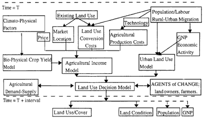
Fig.2 Conceptual Framework of the Model
4.Conclusions
Our aim in developing the "agent-based" model was to mimic the changes by including all the major forces that drive land use changes as well as the basic bio-physical characteristics at the lowest level of interaction (land-lot-size), to help in constructing the possible land use change scenarios. Also, it would help to evaluate our understanding of the land use change mechanisms. The results from the first sub-model, the agricultural productivity sub-model, shows that the yield values are very much within the acceptable range of estimation and the approach has a high potential in estimating yields.
The income sub-model depends heavily on the initial data and the tuning of the model according to it. Historical data can be used to develop scenarios of land use changes and the model can also be validated with such data. In addition to it, the use of remote sensing images can be made to compare the estimated land cover from the model, with the measured values. In this case, care must be taken to maintain the spatial resolution at acceptable levels of comparison.
The entire modeling approach is based on the GIS platform. The use of GIS platform and its tools has helped in analyzing the micro-information (spatial) with in the boundaries of the available macro-level (non-spatial) data. The results of the model application to simulating land use changes within the national boundaries of the Royal Kingdom of Thailand, the case study region, will be presented at the conference.
References
Abstract:
AGENT-LUC, Anthropogenically Engineered Transformation of Land Use and Land Cover Model, is a national scale model, that allows for dynamics time-series simulation and analysis of the changes brought about in the land use by the action of humans within the boundaries of the natural terrestrial earth system. The model deals with the application of the concept of "agent" as the decision-maker in simulating the land use/ land cover changes. The agent decides on the next course of action based on the information available to him from both the worlds of micro and macro-information. The bio-physical characteristics of the land is considered along with its economic condition, given the social apparatus at a given point in time, in arriving at the choice of the land use. The entire process is carried out on a grid-by-grid basis, and is aggregated at the different scales to analyze and the results compared with the prevailing macro-condition. This kind of bottom-up approach with inter-scale aggregations help to develop more realistic scenario of the land use changes. The use of GIS platform and its tools has helped in analyzing the micro-information (spatial) within the boundaries of the available macro-level (non-spatial) data.
1. Introduction
Most of the global physical and biological models that have been developed for the understanding of the various parts of the global earth system, are dependent on the land use and land cover information, as these with their control on the albedo and water & nutrient cycling establish the boundary conditions to these models (Robinson, 1994). Land use/ land cover is continuously changing, both under the influence of humans and nature, resulting in various kinds of impacts on the ecosystem (Rajan, et. al., 1997a). These impacts at local, regional and global levels have the potential to significantly affect the sustainability of the world agricultural systems and the forest systems- the two major human life supporting systems. The most important factor in the modification of the land cover and its conversion is the human use component rather than the natural changes (Turner, et. al., 1993). Changes in the land cover cannot be understood without a better knowledge of the land use changes that drive them and their links to human causes. The linkages between the human and biophysical causes or drivers to land management and land cover are not sufficiently understood (Rajan et. a., 1997b). This arises from the complexity in dealing with the considerable variations in the land use drivers; land use and land cover at the various levels-local, national and regional.
At present, the global models and studies of land use changes capture the broad sectoral trend based on the changes in some of the macro variables, like population, quality of life and technology level. The statistical data shows a strong support in concluding that these variables may be the underlying drivers of environmental changes (Bilsborrow et. al., 1992). On the other hand, such statistical relationship do not hold good for long-term analysis if the trends are dominated more by policy options, like export oriented agricultural production of cassava, and not by the inherent needs of the population, as seen in Fig. 1 , for Thailand. Around 10% of the Cassava produced is consumed domestically, while the rest is mainly for export markets.
Land use can be looked upon as a multi-dimensional (³4D) process, which consequently poses many difficulties for proper description and classification. In the context of global change, the formal characteristics of land use. i.e. its effect on cover structure, phenology and composition, is more relevant than the purpose of function of landuse (Veldkamp et. al., 1996). But, unless the function is properly understood, it is difficult to amalgamate the land use conditions into the processes that drive the changes in land use and land cover. Most of the changes are highly dependent on the biophysical constraints of the land units and the human understandings of these. The model should be able to simulate land use/land cover changes in response to both the biophysical constraints - existing and the changes within, and the socio-economic conditions prevailing at a given point of time. The socio-economic factors like the population, economic, conditions, educational levels etc. are the human drivers that have to be considered in such a model. It is recognized that changes in the scale of analysis, changes the results. As such, it is necessary to consider the feedback effects in such models, as these feedbacks also act as causes or drivers at different scales of analysis and interpretation should be taken into account.
Fig 1 Cassava Production and Population distribution in Thailand for the period 1961 to 1991.
Here, in this paper we describe a new concept that can be used to effectively model the macro-characteristics that describe the landuse along with the known macro-variables that also influence such changes. First, we describe the general concept and principles and issue of the new concept developed by us. Also, its applicability will be discussed within the framework of developing a land use/cover change model at the national level.
2. AGENT-LUC Model
2.1 Concepts and Principles
Land evaluation and suitability has long used the biophysical factors like climate and soil as its determining factors. (FAO, 1978) but the influence of human factors are not so well studies and described. Also, there exists considerable gap between the potential suitability of a given area to its actual productivity. Recent advances in modeling crop-yields based on their phenology have yielded better results, though the majority of them are point/location-specific.
In order to model land use/cover changes under the assumption that its function is influenced by the prevailing economic conditions at a given place and time, it is necessary to evaluate or estimate the scenario that closely resembles reality. The human ability to comprehend and anticipate (with a limited risk) needs to be considered in deriving land use/cover changes. The model proposed here deals with the development and application of a new concept, proposed by the authors, in simulating the land use/cover changes-the presence of an agent as the decision-maker. The agent decides on the next course of action based on the information available to him from both the worlds of macro information. The decision making process takes into consideration the prevailing bio-physical characteristics of the land, the economic condition, and the land use history along with the existing social apparatus in a given year, for arriving at the choice of the annual land use.
Concept of an agent
Here, the term agent refers to an individual or a group of individuals who exist in a given area (referred to as grid) and are capable of making decisions for themselves (or the given area). The agent also acts as an interface in helping to assimilate the broader macro-information into the decision-making process at the grid level, thereby creating an action in response to the natural and economic stimuli.
World of Micro and Macro Information
In this paper, the term 'micro' refers to the data used at the grid level in assessing the supportability of each grid. The crop-specific productivity is calculated at the grid-level, considering the local bio-physical characteristics. The bio-physical attributes considered here, are the climate (temperature, rain and radiation) and soil properties, along with water and nutrient stresses to agricultural productivity.
The 'world of macro' information refers to the data at the sub-national (regional or provincial) or national level. This data is mainly statistical in nature. It is used to compare and adjust the model simulations, to arrive at realistic cause-effect relationship within the model. The macro-data considered are total agricultural demand and supply in a given year, the GNP per capita changes, the contribution of the agricultural and non-agricultural sectors to GNP, and population distributions at the National and sub-national levels.
Additional Information Used
In addition to the above data, the experience of different researchers in arriving at qualitative conclusions on the land use practices in the difference regions of the study area are also considered in charting out the behavioral patterns of the agents.
2.2 Model Description
The overall framework of the model is given below, in Fig. 2. The model consists of four sun-models- the bio-physical crop yield sub-model, the agricultural income sub-model, the urban land use sub-model and the land use decision sub-model. All these four sub-models interact and have feedback loops, to determine the new course of action by the agent at the next time step. The model structure is sequential. The model calculations were carried out on a land unit basis, consisting of 1 km square grids.
The bio-physical crop yield sub-model calculates the potential productivity of the land unit for the given conditions of soil, topography, water availability and climatic parameters. The distribution of water availability takes into account the soil conditions, amount of rain-received, and the existence of irrigation facilities. The main assumption of this sub-model is that these are a strong linkage between the climate and crop distributions. (Leemans, et. al., 1993). The crop yield estimates are derived by modifying the approach described in the EPIC model (EPIC, 1990). The central concept of this approach is the growing period and the photosynthetic efficiency of the crops. The biomass and yield calculations are carried out on a day-to day-basis and the final yield takes into effect the fluctuations in water and nutrient availability.
The agricultural income sub-model estimates the income per land unit from various sources including the yield-related revenue and the cost of production. The model also accounts for the initial cost incurred in land conversion from other uses to agricultural lands. The other incomes considered are the non-yield-on-farm income and the off-farm income. These factors influence the decision making process, in case of fluctuating crop-yield incomes from a given area.
Urban land use is the other major land use that is primarily influenced by the activities of the human beings. Here, we estimate the urban land requirements as its competes with the agricultural areas due to increasing population pressures and the rise in the economic levels of the region. The model takes into account the location value of the land-unit in assessing the new areas that will be urbanized. The model assumes that all the extra land needed for the urban areas in a given year is fulfilled in the next year. The model provides information on the urban land demand and supply, on a spatial basis.
The final step in the simulation is the land use decision model, which uses the estimated income, urban land needs & the existing landuse in the land unit under consideration as its input to predict the land use. The "agent" is the decision maker in this model, where in the agent arrives at a decision taking into account the prevailing conditions in the respective grids. In addition to the economic factor, the demographic condition (age distribution and educational levels) and the land use history are considered to help in arriving at a reasonable estimate for the changes in the land use patterns. The decision includes the consideration of risk when arriving at the crop combinations in the respective grids. Also, the model accounts for the external influences to shifts in the agricultural patterns, by considering the export quantities of specific crops, like cassava in Thailand. As of now, these external influences are exogenous variables and are not calculated within the model.
3. Study Area
The study area chosen to check the application of this model is the Royal Kingdom of Thailand, because land use/cover in Thailand has undergone dramatic modifications in the last century. Cultivated land area has shown an astounding increase by nearly ten-times, a net increase in area by about 16.4 million hectares, during the period 1880-1980 and has since risen by 10% till 1990. The model run is for the period of 1980-1990. This period was chosen to check the model simulation (on a year-on-year basis), because of two reasons - one that it being a recent period in history helps us to get a substantial amount of information on some of the causes for changes including quite detailed data at the sub-provincial level. The second reason is that this has been a period of rapid changes in the country's economic structure and the model-run would help us to understand the pitfalls and the better points in our assumptions.
Fig.2 Conceptual Framework of the Model
4.Conclusions
Our aim in developing the "agent-based" model was to mimic the changes by including all the major forces that drive land use changes as well as the basic bio-physical characteristics at the lowest level of interaction (land-lot-size), to help in constructing the possible land use change scenarios. Also, it would help to evaluate our understanding of the land use change mechanisms. The results from the first sub-model, the agricultural productivity sub-model, shows that the yield values are very much within the acceptable range of estimation and the approach has a high potential in estimating yields.
The income sub-model depends heavily on the initial data and the tuning of the model according to it. Historical data can be used to develop scenarios of land use changes and the model can also be validated with such data. In addition to it, the use of remote sensing images can be made to compare the estimated land cover from the model, with the measured values. In this case, care must be taken to maintain the spatial resolution at acceptable levels of comparison.
The entire modeling approach is based on the GIS platform. The use of GIS platform and its tools has helped in analyzing the micro-information (spatial) with in the boundaries of the available macro-level (non-spatial) data. The results of the model application to simulating land use changes within the national boundaries of the Royal Kingdom of Thailand, the case study region, will be presented at the conference.
References
- Alcamo, J., Kreileman, G.J.J., Krol, M. and Zuidema, G., 1994. Modelling the Global society-biosphere-climate system. 1. Model description and testing. Water Air Soil Pollution, 76, pp.1-35.
- Bilsborrow, R.W. and Okoth-Ogendo, H.W.O., 1992. Pollution-driven changes in land use in developing countries. Ambio, 21, pp.37-45.
- FAO., 1978. Report on the Agro-Ecological Zones Project, Food and Agricultural Organization of the United Nations, World Soil Resources report 48, Rome.
- Leemans R. and Solomon A.M., 1993. Modelling the Potential Change in Yield and Distribution of the Earth's Crops under a warmed Climate, Climate Research Vol.3.
- Rajan, K.S. and Shibasaki, R., 1997a. Estimation of Agricultural Productivity and Its Application to Modelling the Expansion of Agricultural Land in Thailand. Journal of Agricultural Meteorology, 52(5), pp.815-818.
- Rajan, K.S., and Shibasaki, R., 1997b, National Scale Land Use Change Modelling - Issues and Application. In. Proceedings of the 18th Asian Conference on Remote Sensing, Kuala Lumpur, Malaysia, pp. H-2.
- Robinson, J. 1994. Land-use and Land-cover projections. Report of working group C in Changes in Land Use and Land Cover: A Global Perspective' (Editors: Meyer and Turner) Cambridge Univ. Press.
- Sharpley, A.N. and Williams, J.R., (eds.) 1990. EPIC-Erosion/Productivity Impact Calculator: 1. Model Documentation, USDA Technical Bulletin No. 1768.
- Turner II, B.I., Moss, R.H., and Skole, D.L. (Editors), 1993. Relating land use and global land-cover change: a proposal for an IGBP-HDP core project. IGBP report No.24 and HDP report No. 5, 65pp.
- Veldkamp, A. and Fresco, L.O., 1996. CLUE: a conceptual model to study the conversion of land use and its effects. Ecol. Model., 85:253-270.
- Wegener, M., 1994. Urban/regional models and planning cultures: lessons from cross-national modeling projects. Environment and Planning B: Planning and Design, 21: 629-641.