| GISdevelopment.net ---> AARS ---> ACRS 1999 ---> Hyper Spectral Image Processing |
Development of High
Resolution Imaging Spectrometer
Bingxi Yu, Gang Wang, etc.
Changchun Institute of Optics and Fine Mechanics,
Chinese Academy of Sciences
Changchun Institute of Optics and Fine Mechanics,
Chinese Academy of Sciences
Keywords: imaging spectrometer, satellite,
remote sensing.
Abstract
This paper describes the development results of the prototype of China high resolution imaging spectrometer (C-HRIS). The application requirements of agriculture, resource survey and environment monitor and the corresponding technique parameters are analyzed. The design and performance of the optics, optomechanical system, and electronics are also given. The ground and in-flight experiment results are presented.
1. Introduction
In the past 20 years, several airborne imaging spectrometers have been developed and put into extensive flight experiments and application researches. These works have revealed and found enormous value and potential applications for remote sensing with high spectral resolution and fine wavelength sampling. NASA and ESA have been engaging in the development of satellite-borne imaging spectrometer since the middle of 80’s for expanding the application abilities to global scale earth observation. According to the application requirements, imaging spectrometers are divided into high resolution (about 1km ground resolution) and moderate one (about 10m ground resolution). The MODIS of NASA and the MERIS of ESA are airborne moderate imaging spectrometer, and will be launched in the future.
In the development of high resolution imaging spectrometer, NASA included a high resolution imaging spectrometer (HIRIS) in the early Earth Observing System (EOS) program. However, the development of HIRIS was canceled from the EOS later. Then the instrument is included in the effective loads of NASA small satellite programs, carried on by TRW and renamed hyperspectral Imager (HSI). Unfortunately, in Aug.1988, one month after its launch, HSI was dropped from space.
At present, ESA are developing two types of high-resolution spectrometer, HRIS for ENVISAT, and PRISM for the Explorer.
According to recent reports, Australia plans to develop high resolution imaging spectrometer for geology and miner survey.
In USA, there are several high resolution imaging spectrometer planed to be developed, such as those for NEMO (Naval Earth Map Observer), EO-1 satellite, and HRST satellite. High resolution imaging spectrometer has high ground resolution and high spectral resolution, with 128 spectral channels. It can detect important ground characteristics that cannot be detected by mutilspectral remote sensing instruments. It can measure all absorption and reflectance characteristics of ground objects. It has the capabilities of analyzing components of solid and liquid object, and diagnosing physical, chemical, and biological performance of organism. It can meet the requirements of fine space observation sufficiently.
This paper describes the development results of the prototype of China high resolution imaging spectrometer (C-HRIS), and its configuration, performance and experiment results are presented.
2. Mission requirements and technique parameters
2.1 Mission requirements
China has a large population, relatively poor resource, complicated natural environments, and frequent weather and geological disaster. With the development of industry and agriculture, the problems of environment pollution, ecological change, and so on, become more and more critical. In order to maintain a continuous and stable development of economy, it is necessary to develop advanced remote sensing instruments for obtaining the fine basic data and dynamic change about land, resource and environment by means of remote sensing from satellite.
2.1.1. Agriculture
Land resource and utilization: distribution and changes of land, grass, forest, sand and bare land, rocky mountain, glacier, accumulated snow, desert, tidal flat, marsh, lake, residence area, industry deposit, road, river, etc..
Soil type: humus content, moisture content, humidity, salinization and erosion.
Crops and vegetation: crop type, area growing trend, production; green wave movement, living being quantity estimation, forest area, wood storage, plant diseases and insect pests, foster and renewal, grass type, production and supported animal quantity.
2.1.2. Geology and miner survey
Mineral deposit distribution, future prediction, quality evaluation, storage estimation of petroleum, gas, coal, black metals, color metals, nonmetals, etc..
Basic geological information of large engineering of transportation, waterpower, mine, earthquake zone, fault zone, hydrology and hidden troubles.
2.1.3. Offshore and water systems on land
Coastal line, islands, islets, tidal flats, reefs, estuaries, silt deposition and diffusion.
Water systems on land, water quality.
2.2 Specification
According to the above mission requirements, we determined the technique parameters of the C-HRIS prototype as shown in Table 1. The satellite is a solar synchronous polar orbit satellite. Its altitude is 800 km and the inclination angle is 99°. The local time of crossing point is 10:30. The circle time is 101 minutes and the ground velocity is 6.6Km/s. Every 16 days, the satellites will passe over the same swath of ground.
Table 1. The main technique parameters
of the prototype
3. Instrument description
C-HRIS uses two area array detectors and operates in pushbroom mode. Two slits are used at the focal plane of the telescope to separate the spectral waveband into VNIR and SWIR. 128 waveband imaging spectral data ranging from 0.43mm, which is obtained through two flat field spectrometer and CCD and InSb area array detectors. The principles and the photo of the prototype are as shown in Figure 1 and 2, respectively.
The experiments on the prototype show that the imaging quality is good. Its MTF reaches 0.6, the spectral transmittance is very high over the whole spectral range, and spectral resolution meets the design requirement.
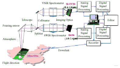
Fig.1 The schematic digrams of C-HRIS.

Fig.2 The photo of C-HRIS prototype.
A pointing mirror is arranged in front of the telescope to provide ±30° view variation in the direction of crosstrack, so any stripes on the ground in the width of ±230km perpendicular to the ground can be observed.
3.1 Optics
The optics of the C-HRIS is special and complicated, which is composed of one telescope and two-flat-field spectrometer, as shown in Fig.3.
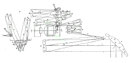
Fig.3 The optics of C-HRIS.
The telescope is an all-spherical-surface 5-reflector Shafer system. The flat field spectrometers VNIR and SWIR are prism chromatic dispersed, off-axial spherical surface spectral imaging system (OASIS).
3.2 Optomechanics
The optomechanical system adopts a module structure, and is arranged in three lays: the upper, the middle and the lower. Module unit is composed of pointing mirror, telescope objective, imaging system, spectral band splitter, VNIR and SWIR spectrometers, CCD detector, InSb detector, and a main box.
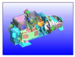
Fig.4 CAD diagram of the optomechanic system of C-HRIS.
3.3 Electronics
The electronics consists of CCD and InSb detector synchronous drivers, low-noise wide-frequency-band analog signal processing subunit, high speed digital signal processing subunit, editor, recorder, image displaying in real time subunit, pointing control subunit, calibrations subunit, power supply, and central control computer.
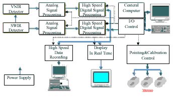
Fig. 5 The electronic diagram of the C-HRIS.
4. Performance and experiments
The prototype performance, such as ground resolution (IFOV), spectral resolution, SNR, and MTF, have been measured in the experiment. Spectral calibration and radiometric calibration have also been performed. The experimental results show that our prototype has reached advanced level of the same type of instrument all over the world. Because a prism is used as dispersion element, spectral resolution is a little different at different wavelength. The signal-to-noise ratio curve is shown in Fig. 6.
The 128-waveband hyperspectral images ranging from visible to short wave infrared have being obtained by the ground and the helicopter imaging spectral experiments. Sharp image, high spatial resolution, and obvious spectral characteristics of ground objects are obtained with the prototype. Images and spectra collected in the flight experiment are shown in Figure7,8 and 9. The absorption band of atmospheric components such as H2O and O2 are distinguished from 128-band spectral sampling data of pixels.
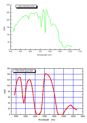
Fig.6 The signal-to-noise ratio curve of C-HRIS prototype.

Fig.7 Image of VNIR band.
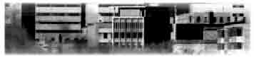
Fig.8 Image of SWIR band.
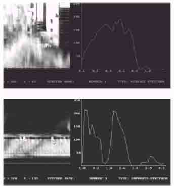
Fig.9 Spectral curve form a pixel.
5. Conclusion
The purpose of developing C-HRIS is to probe the methods to develop the next airborne engineering prototype, and master the critical techniques. The goal has been realized by this research.
6. References
Abstract
This paper describes the development results of the prototype of China high resolution imaging spectrometer (C-HRIS). The application requirements of agriculture, resource survey and environment monitor and the corresponding technique parameters are analyzed. The design and performance of the optics, optomechanical system, and electronics are also given. The ground and in-flight experiment results are presented.
1. Introduction
In the past 20 years, several airborne imaging spectrometers have been developed and put into extensive flight experiments and application researches. These works have revealed and found enormous value and potential applications for remote sensing with high spectral resolution and fine wavelength sampling. NASA and ESA have been engaging in the development of satellite-borne imaging spectrometer since the middle of 80’s for expanding the application abilities to global scale earth observation. According to the application requirements, imaging spectrometers are divided into high resolution (about 1km ground resolution) and moderate one (about 10m ground resolution). The MODIS of NASA and the MERIS of ESA are airborne moderate imaging spectrometer, and will be launched in the future.
In the development of high resolution imaging spectrometer, NASA included a high resolution imaging spectrometer (HIRIS) in the early Earth Observing System (EOS) program. However, the development of HIRIS was canceled from the EOS later. Then the instrument is included in the effective loads of NASA small satellite programs, carried on by TRW and renamed hyperspectral Imager (HSI). Unfortunately, in Aug.1988, one month after its launch, HSI was dropped from space.
At present, ESA are developing two types of high-resolution spectrometer, HRIS for ENVISAT, and PRISM for the Explorer.
According to recent reports, Australia plans to develop high resolution imaging spectrometer for geology and miner survey.
In USA, there are several high resolution imaging spectrometer planed to be developed, such as those for NEMO (Naval Earth Map Observer), EO-1 satellite, and HRST satellite. High resolution imaging spectrometer has high ground resolution and high spectral resolution, with 128 spectral channels. It can detect important ground characteristics that cannot be detected by mutilspectral remote sensing instruments. It can measure all absorption and reflectance characteristics of ground objects. It has the capabilities of analyzing components of solid and liquid object, and diagnosing physical, chemical, and biological performance of organism. It can meet the requirements of fine space observation sufficiently.
This paper describes the development results of the prototype of China high resolution imaging spectrometer (C-HRIS), and its configuration, performance and experiment results are presented.
2. Mission requirements and technique parameters
2.1 Mission requirements
China has a large population, relatively poor resource, complicated natural environments, and frequent weather and geological disaster. With the development of industry and agriculture, the problems of environment pollution, ecological change, and so on, become more and more critical. In order to maintain a continuous and stable development of economy, it is necessary to develop advanced remote sensing instruments for obtaining the fine basic data and dynamic change about land, resource and environment by means of remote sensing from satellite.
2.1.1. Agriculture
Land resource and utilization: distribution and changes of land, grass, forest, sand and bare land, rocky mountain, glacier, accumulated snow, desert, tidal flat, marsh, lake, residence area, industry deposit, road, river, etc..
Soil type: humus content, moisture content, humidity, salinization and erosion.
Crops and vegetation: crop type, area growing trend, production; green wave movement, living being quantity estimation, forest area, wood storage, plant diseases and insect pests, foster and renewal, grass type, production and supported animal quantity.
2.1.2. Geology and miner survey
Mineral deposit distribution, future prediction, quality evaluation, storage estimation of petroleum, gas, coal, black metals, color metals, nonmetals, etc..
Basic geological information of large engineering of transportation, waterpower, mine, earthquake zone, fault zone, hydrology and hidden troubles.
2.1.3. Offshore and water systems on land
Coastal line, islands, islets, tidal flats, reefs, estuaries, silt deposition and diffusion.
Water systems on land, water quality.
2.2 Specification
According to the above mission requirements, we determined the technique parameters of the C-HRIS prototype as shown in Table 1. The satellite is a solar synchronous polar orbit satellite. Its altitude is 800 km and the inclination angle is 99°. The local time of crossing point is 10:30. The circle time is 101 minutes and the ground velocity is 6.6Km/s. Every 16 days, the satellites will passe over the same swath of ground.
| Ground resolution | 40m |
| IFOV | 0.05mrad |
| Spectral range | 0.43~2.4um |
| Spectral resolution | VNIR: 10nm (0.43~1.0 um) SWIR: 20nm (1.0~2.4 um) |
| Spectral channel number | 128 (VNIR64, SWIR64) |
| Optical system | f=600mm FN=3 |
| Focal plane array ( prototype) | VNIR:
Si-CCD 256pixel*64spectrum SWIR: InSb 256pixel*64spectrum |
| Pointing mirror crosstrack | ±30° |
3. Instrument description
C-HRIS uses two area array detectors and operates in pushbroom mode. Two slits are used at the focal plane of the telescope to separate the spectral waveband into VNIR and SWIR. 128 waveband imaging spectral data ranging from 0.43mm, which is obtained through two flat field spectrometer and CCD and InSb area array detectors. The principles and the photo of the prototype are as shown in Figure 1 and 2, respectively.
The experiments on the prototype show that the imaging quality is good. Its MTF reaches 0.6, the spectral transmittance is very high over the whole spectral range, and spectral resolution meets the design requirement.
Fig.1 The schematic digrams of C-HRIS.
Fig.2 The photo of C-HRIS prototype.
A pointing mirror is arranged in front of the telescope to provide ±30° view variation in the direction of crosstrack, so any stripes on the ground in the width of ±230km perpendicular to the ground can be observed.
3.1 Optics
The optics of the C-HRIS is special and complicated, which is composed of one telescope and two-flat-field spectrometer, as shown in Fig.3.
Fig.3 The optics of C-HRIS.
The telescope is an all-spherical-surface 5-reflector Shafer system. The flat field spectrometers VNIR and SWIR are prism chromatic dispersed, off-axial spherical surface spectral imaging system (OASIS).
3.2 Optomechanics
The optomechanical system adopts a module structure, and is arranged in three lays: the upper, the middle and the lower. Module unit is composed of pointing mirror, telescope objective, imaging system, spectral band splitter, VNIR and SWIR spectrometers, CCD detector, InSb detector, and a main box.
Fig.4 CAD diagram of the optomechanic system of C-HRIS.
3.3 Electronics
The electronics consists of CCD and InSb detector synchronous drivers, low-noise wide-frequency-band analog signal processing subunit, high speed digital signal processing subunit, editor, recorder, image displaying in real time subunit, pointing control subunit, calibrations subunit, power supply, and central control computer.
Fig. 5 The electronic diagram of the C-HRIS.
4. Performance and experiments
The prototype performance, such as ground resolution (IFOV), spectral resolution, SNR, and MTF, have been measured in the experiment. Spectral calibration and radiometric calibration have also been performed. The experimental results show that our prototype has reached advanced level of the same type of instrument all over the world. Because a prism is used as dispersion element, spectral resolution is a little different at different wavelength. The signal-to-noise ratio curve is shown in Fig. 6.
The 128-waveband hyperspectral images ranging from visible to short wave infrared have being obtained by the ground and the helicopter imaging spectral experiments. Sharp image, high spatial resolution, and obvious spectral characteristics of ground objects are obtained with the prototype. Images and spectra collected in the flight experiment are shown in Figure7,8 and 9. The absorption band of atmospheric components such as H2O and O2 are distinguished from 128-band spectral sampling data of pixels.
Fig.6 The signal-to-noise ratio curve of C-HRIS prototype.
Fig.7 Image of VNIR band.
Fig.8 Image of SWIR band.
Fig.9 Spectral curve form a pixel.
5. Conclusion
The purpose of developing C-HRIS is to probe the methods to develop the next airborne engineering prototype, and master the critical techniques. The goal has been realized by this research.
6. References
- B.Kunkel et al..“Hyperspectral Imager Survey and Developments for Scientific and Operation Land Processes Monitoring Applications”SPIE.Vo l.3107. PP.2-14.1997
- T.S.Pagano et al..“Development of the Moderate Resolution Imaging Spectrometer .MODIS.Protoflight Model”SPIE.Vo l.2820. P.109
- G.Baudin et al..“Medium-Resolution Imaging Spectrometer.MERIS.”SPIE.Vo l.2209.P.115
- C.T.Willoughby et al..“Hyperspectral Imaging Payload for the NASA Small Satellite Technology Initiative Program”IEEE.PAP2.DOC.Nov.1996
- B.Kunkel et al..“High Resolution Imaging Spectrometer HRIS-Optics.Focal Plane and Calibration”SPIE.Vo l.1937 PP.207-224.1993
- B.Kunkel et al..“High-Resolution Hyperspectral Imager for Land Processes in ESA Earth Observation Programmers.HRIS and PRISM..IAF Congr.1996.Paper .IAF-B 03.02. Oct.96”