| GISdevelopment.net ---> AARS ---> ACRS 1999 ---> Hyper Spectral Image Processing |
Mapping the Comstock
Epithermal Mineralisation system, Nevada, using Simulated ARIES-I
Hyperspectral Data
Kai Yang1,
Jonathan F. Huntington1 and Joseph W.
Boardman2
1CSIRO Exploration and Mining, PO Box 136, North Ryde, NSW 2113, Australia
2Analytical Imaging and Geophysics, 4450 Arapahoe Ave, Boulder, Colorado, 80303, USA
Abstract1CSIRO Exploration and Mining, PO Box 136, North Ryde, NSW 2113, Australia
2Analytical Imaging and Geophysics, 4450 Arapahoe Ave, Boulder, Colorado, 80303, USA
The hydrothermal alteration in the Miocene andesitic to rhyolitic volcanic rocks in the Comstock mining district near Virginia City, Nevada was mapped by using simulated spaceborne Hyperspectral data, which was part of the feasibility studies to simulate the mineral mapping capability of the proposed Australian satellite, ARIES-1.
The mapped hydrothermal alteration ranges from the phyllic, propylitic, advanced argillic and argillic types. They represent various environments of the hydrothermal system. Detailed discrimination was made to illites according to their aluminum content, and to kaolin clays according to their crystallinity. These subtle mineralogical changes provide further information on the hydrothermal alteration process. The results show that ARIES-1 will be capable of providing Hyperspectral data that are useful for high-resolution mineral mapping.
1. Introduction
The Australian Resource Information and Environment Satellite, ARIES-1, due for commercial operation from 2003, is designed to provide hyper spectral data about the Earth's surface composition. The proposed ARIES-1 will image the Earth in 105 contiguous channels from 0.4 to 2.5 mm (20 nm and 16 nm band spacing in the visible and SWIR, respectively), with 30 meter ground pixel size and 15 swath width at nadir. To test ARIES-1's mineral mapping capability, simulations were carried out in the Comstock mining district using NASA's AVIRIS hyper spectral data.
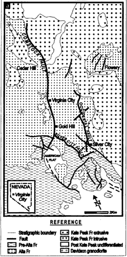
The Comstock mining district, Nevada is well-known for its low-sulfidation type epithermal Au-Ag mineralisation. This district comprises four quartz-dominated vein systems, of which the Comstock lode is the largest one (Vikre, 1989). These mineralized systems are located in or near normal faults (Figure 1).
Miocene andesitic to dacitic volcanic rocks (Alta and Kate Peak formations) are the main lithologies exposed in the district. These Miocene volcanic rocks overlie the Mesozoic basement consisting of metamorphosed sedimentary, volcanic and granite rocks. The Miocene volcanic rocks are extensively and variably altered, due to pre-, syn-, or post-mineralisation hydrothermal activities. A variety of hydrothermal alteration assemblages, including phyllic, propylitic, alunitic and argillic ones, were previously recognized (Whitebread 1976; Hutsinpillar 1988). The most prominent alteration feature of the Miocene volcanic rocks is 'bleaching', which is caused by development of abundant clay minerals, alunite and quartz.
 |
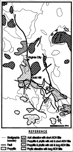 |
| Figure 1. Geological (a) and hydrothermal alteration (b) maps of the Comstock mining district, Nevada. The geological map is after Vikre (1989). The hydrothermal alteration map is generalized from the mineral mapping results of this study. | |
Au-Ag mineralisation in the Comstock mining district is hosted mainly in quartz veins and stock works. Mineralisation of less importance occurs in breccias and silicified zones. The mineralized veins strike predominately north + 300, expect those related to the Silver city fault which run nearly east-west. Veins are hosted mainly in the Alta Formation. The age of Au-Ag mineralisation in the district is 14-12 Ma, coeval with the Kate Peak volcanism.
2. Methods
The original data were acquired in 1995 by NASA's Airborne Visible and Infrared Imaging Spectrometer (AVIRIS). In this simulated mineral mapping, the original AVIRIS data (224 bands from 0.4 mm to 2.5 mm; 20 m pixel) were re-sampled according to the proposed ARIES-1 specifications (105 bands from 0.4 mm to 2.5 mm; 30 m pixel, signal to noise ratio between 1000 and 400.). the reduced data were then processed to remove atmospheric effects (ATREM, Gao et. al. 1997) and instrument noise (EFFORT, Boardman 1998) to derive the apparent ground reflectance. The 32 short-wave infrared bands of ARIES from 2.0 mm to 2.5 mm were further processed to derive mineral end-members present in the scene. The ENVI software package was used for the spectral processing and mapping work.
Relative abundance of the key alteration minerals such as lillite, chlorite, kaolin clays and alunite was determined based on the digital number of the respective end-member minerals unmixed from the scene.
For ground validation, field spectral work was carried out with an ISPL PIMA-II portable infrared spectrometer. The PIMA-II instrument measures the hemispherical reflectance in 601 channels in the wavelengths region from 1.4 to 2.5 mm.
3. Results
In the Hyperspectral mineral mapping, advanced argillic, argillic, propylitic, and phyllic alteration zones were identified by the occurrence of alunite, kaolin clays, chlorite, and illite as the dominant alteration minerals, respectively. The spectra of these minerals, derived from unmixing of the airborne hyper spectral reflectance data, are displayed in Figure 2.
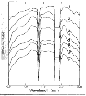
Figure 2 Stacked reflectance spectra of end-member minerals unmixed from the simulated hyper spectral data.
2.alunite,
3-kaolite,
4-dickite,
5-long Al-OH wavelength illite,
6-medium Al-OH wavelength illite,
7-short Al-OH wavelength illite,
The absorption minima of the Al-OH band for the three illities are approximately at 2212 nm, 2204 nm and 2194 nm respectively.
The mapping results show that two kaolin clays, dickite and kaolinite, commonly coexist in the bleached zones (Figure 3). The most significant enrichment of dickite was identified around Gold Hill in the central part, and near Cedar Hill in the northern part of the mapped area. As expected, alunite is spatially associated with kaolin, although the mapped alunite outcrops are less extensive simply because alunite is less abundant than kaolin in the bleached rocks.
Illite enrichment was mapped in large outcrops in the central and south-central parts of the district (Figure 3d-f). Three types of illite with long (2212 nm), medium (2204 nm) and short (2194 nm) Al-OH absorption features, respectively, were distinguished.
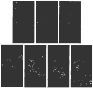
Figure 3. Area distribution of kaolinite (a), alunite (b), dickite (c), illite with short (d), medium (e) and long (f) Al-OH wavelengths and chlorite (g) in the Comstock mining district. Relative mineral abundance corresponding to digital numbers from 0.1 and 0.6 is stretched from black (undetectable) to white (most abundant). Major faults are marked. The images cover the same area as shown in Figure 1. see Figure 2 for the spectra of the end-member minerals.
The illite with short Al-OH absorption wavelengths is located dominantly in the bleached volcanic rocks. This illite occurs mainly along or east of the Comstock and Silver City Faults (Figure 3d). It commonly coexists with kaolin clays and alunite and so belongs to the advanced argillic assemblage.
The illite with long Al-OH band wavelengths occurs mainly in the unbleached Alta and Kate Peak Formations west of the Comstock and Silver City Faults and in the Mesozoic rocks in the southern part of the district (Figure 3f). This type of illite forms part if the propyllic or phyllic assemblages.
The medium Al-OH absorption wavelengths illite was mapped mainly in the central part of the district, close to the Comstock Fault between Virginia City and Gold Hill and around the Flowery mine (Figure 3e).
Propylite alteration, as indicated by chlorite enrichment, has extensively affected rocks of the mapped area, especially in the central and southern parts (Figure 3g). In contrast to the kaolin clays, chlorite tends to develop west of the Comstock fault in the central part, or away from the fault in the southern part of the district.
The mapped area distribution of the various alteration assemblages were confirmed by ground validation with field spectral measurement using the PIMA-II portable infrared spectrometer.
4 Discussion
The results show that the bleached zones are developed in the central and northern parts of the district, mainly in the hanging wall, or at relatively high elevations in the footwall, of the Comstock and Silver City Faults. The presence in the bleached zones of dickite and pyrophllite that formed at relatively high temperature suggests that the advanced argillic alteration probably resulted from ascending magmatic fluids.
Illite in the bleached zones is characterized by relatively short Al-OH absorption wavelengths (2190-2200 nm). This Al-OH wavelengths range implies that the illite contains very low octahedral Fe and Mg (similar to muscovite). This composition is characteristic of illite formed in acidic hydrothermal conditions.
The assemblage of short Al-OH wavelengths illite, alunite and kaolin clay represents the hydrothermal alteration at shallow depths in the fluid up-flow zones of the hydrothermal system. Note that Au-Ag mineralisation in this district is spatially associated with parts of the bleached zones.
Propylitic alteration was mapped as chlorite enrichment in the central part of the district near the Davidson granodiorite and Cedar Hill west of the Comstock Fault (Figures 1). The coexisting illite shows medium, and less commonly short Al-OH band wavelengths. This propulitic zone could be the alteration caused by the Davidson intrusion immediately preceding the Au-Ag mineralsation, or it represents a syn-mineralsation event.
The more extensive propylitic alteration zones in the southern part of the district are not obviously associated with any faults (Figures 1). They are partly developed in the metamorphosed Mesozoic rocks. These zones cloud be the peripheral alteration on the margins (possibly the down flow zones) of the Miocene hydrothermal system.
Phyllic alteration with illite domination was mapped mainly along the Silver City Fault and further south in the Alta Formation and Mesozoic rocks. The illite in these rocks is characterized by relatively long Al-OH band wavelengths (up to 2216 nm), indicating elevated Fe and/or Mg contents in the illite. The long Al-OH wavelengths illite tends to concentrate in the southern part of the district.
Part of the long Al-OH wavelengths illite may have been derived during the one-forming hydrothermal event as it occurs as relic patches in association with the short Al-OH wavelengths variety close to Au-Ag mineralisation near Virginia City and Flowery. It may represent the periphery alteration in the fluid down flow zones and/or the lower parts of the up-flow zones of the minralisation/alteration system.
5. Conclusions
In summary, the mineral mapping simulation indicates:
- The bleached volcanic rocks containing short Al-OH wavelengths illite are located along the major faults and many represent hydrothermal alteration in the fluid discharge zones (and the upper parts) of the Miocene hydrothermal system.
- Fault-controlled propylitic alteration occurs in the footwall of the Comstock Fault in the central part of the district. More extensive propylitic alteration zones characterized by chlorite and long Al-OH wavelengths illite are developed in the southern part of the district, away from the major faults.
- In the mapped area, illite tends to change southwards from short to long Al-OH band wavelengths. This change reflects a decrease in Al(an increase in Fe and/or Mg) in illite, probably due to a decrease in acidity of the hydrothermal fluids from the central (and upper) to the peripheral (and lower) parts of the hydrothermal system.
- The hyper spectral mineral mapping results have provided valuable information about the hydrothermal alteration and mineralisation processes, such as the physical conditions and flow directions of the ore-forming fluids, the alteration mineral assemblage most closely associated with Au-Ag mineralsation and the possible dimension of the hydrothermal system.
- This study demonstrates that ARIES-1 will be capable of providing hyper spectral data for high-precision mineral mapping at a district or regional scale and therefore have great application potential for mineral exploration.
- Gao B-C, Heidebrecht K.B. & Geotz A.F.H. 1997. Atmosphere Removal Program (ATREM), Users Guide, Version 3, University of Colorado, Boulder, USA.
- Boardman J.W. 1998. Post-ATREM polishing of AVIRIS apparent reflectance data using EFFORT: a lesson in accuracy versus precision. In: Green, R.O. (ed) Summaries of the Seventh JPL Airborne Earth Science Workshop, Vol 1, JPL Publication 97-21, pp.53.
- Hutsinpiller A. 1998. Distribution of Hydrothermal Alteration Mineral Assemblages at Virginia City, Nevada, Using the Airborne Imaging Spectrometer. Remote Sensing of Environment 24, 53-66.
- Vikre P.G. 1989. Fluid-mineral relations in the Comstock Lode. Economic Geological 84, 1574-1613.
- Whitebread D.H. 1976. Alteration and Geological of Tertiary Volcanic Rocks in Parts of the Virginia City Quadrangle, Nevada. US Geological Survey Professional Paper No 936.