| GISdevelopment.net ---> AARS ---> ACRS 1999 ---> Hyper Spectral Image Processing |
Simulated Spot-Equivalent
Reflectance Characteristics of Common Reef Features
Heather Holden
Department of Geography
National University of Singapore
AS2 1 Arts Link Singapore 117 570
(65) 874-6101 (tel.), (65) 777-3091 (fax)
Email: geohmh@nus.edu.sg
Ellsworth LeDrew
Waterloo Laboratory for Earth Observations
University of Waterloo
Email: ells@watleo.uwaterloo.ca
Christian Melsheimer
Centre for Remote Imaging, Sensing and Processing
National University of Singapore
Email: crscm@nus.edu.sg
Keywords: hyperspectral, SPOT HRV, coral reef
degradation.
Abstract
Analysis of hyperspectral data has produced encouraging results in the discrimination of common and optically similar coral reef substrates such as healthy corals, bleached corals, sea grass, and algae-covered surfaces, but at the present time, such high spectral resolution data is unavailable from a satellite platform. If currently available satellite imagery is to be used to map and monitor changes in coral reef geographic extent and health, a quantitative procedure must be developed to discriminate healthy coral from other optically similar benthic substrates with coarse spectral resolution. The primary goal of this study is to evaluate the feasibility of using coarse spectral resolution data to map the geographic extent and monitor the changes in coral reef ecosystems. While previous studies have based analysis upon reflectance values extracted from images, an attempt is made here to discriminate common coral reef features using in situ spectral reflectance measurements with spectral resolution equivalent to SPOT HRV data. Results of a one-way analysis of variance suggest that the broad categories of in situ reflectance measurements (n=596) can be considered separate populations with respect to broadband reflectance characteristics.s
1. Introduction
Coral reef ecosystems are difficult and expensive to survey on a regular basis, so remote sensing is being explored as a feasible alternative to aerial photography and traditional ground survey techniques as a means of monitoring reef features (Hardy et al., 1992; Bour et al., 1986). Conventional methods of mapping the geographic extent of coral reefs rely on examination of nautical charts, aerial photography, and underwater observations, which are accomplished following a sampling methodology dependent on substrate type (Luczkovich et al., 1993; de Vel and Bour, 1990; Jupp et al., 1985). These conventional techniques may be sound if the area is small, but they are inadequate for large and/or inaccessible areas, so an alternative means of monitoring coral ecosystem health is required (Holden and LeDrew, 1998b).
Remote sensing is espoused as an ideal tool for resource management and ecosystem monitoring due to its ability to provide quantitative information quickly and relatively inexpensively compared to the cost of employing researchers to observe an equivalent area (Mumby et al., 1998; Hardy et al., 1992). While currently available satellite imagery has global mapping and monitoring capabilities, the accuracy and precision attainable is relatively low due to the large pixel size and broad spectral bandwidths of these sensors (Holden, 1999). Due to the urgency with which coral reef ecosystems need to be mapped and monitored (Wilkinson et al., 1999; Muller-Parker and D’Elia, 1997), waiting for the ideal technology for accurate and precise spatial, spectral, and temporal imaging of submerged coral reef ecosystems is not realistic. Instead, there is a need to utilize the available imaging technology, assess the accuracy and acknowledge the limitations.
The specific objectives of this paper are to examine the in situ spectral reflectance characteristics of common coral reef features such as algae-covered dead coral, bleached coral, and healthy coral to determine the degree to which they are discernible at spectral resolutions equivalent to SPOT HRV. We believe our approach based upon measured in situ spectral reflectance data and calculated SPOT HRV equivalent broadband reflectance data to be an effective means of identifying individual substrate types. This work is performed in anticipation of a project using an historical SPOT HRV data archive at the Centre for Remote Imaging, Sensing and Processing, National University of Singapore, to inspect and document the changes over time in coral reef geographic extent and health in the South China Sea.
2. Study Areas and Data Collection
Data collection has been on going since 1996 in the South Pacific, South East Asia and the Caribbean in an effort to create a global database of coral reef reflectance signatures. Field data collection took place in Beqa Lagoon, Fiji during July and August 1996, Manado, Sulawesi, Indonesia in July and August 1997, Savusavu Bay, Fiji in July and August 1998, and Buck Island National Monument, St. Croix, U.S. Virgin Islands in February 1999.
A hyperspectral radiometer (Analytical Spectral Devices Personal Spectrometer II) with a 20m underwater optical cable and an underwater cosine collector and 22 degree field of view foreoptics allowed reflectance measurements of submerged features while scuba diving. An underwater reference panel enabled determination of reflectance by measuring the nadir radiance of the reference panel immediately prior to each nadir radiance measurement of the feature of interest. The radiometer operator remained above water to take note of sky and water surface conditions and set the integration time. In an effort to reduce the noise factor within each measurement, five reflectance measurements were averaged automatically for each saved spectra. The water present between the radiometer foreoptic and the feature (10cm) is considered negligible, so no correction for attenuation was performed. Underwater photographs were taken of each of the features measured and notes were taken describing the depth, feature type, surrounding substrate, water quality, feature size and morphology as well as any other pertinent information.
In total, 596 spectral reflectance measurements are utilized in this study, each integrated to equal SPOT’s first two wavebands: (1) 500-590nm and (2) 610-680nm. Only the first two wavebands of the SPOT HRV are used here since light in the third band (790-890nm) is completely attenuated in the water column. The bottom type categories were assigned based on identification of the feature in the field and confirmed by inspection of the underwater photographic record. The broad categories are healthy coral (n=276), bleached coral (n=114), macro algae (n=105), rubble (n=77), and sea grass (n=24).
3. Spectral Data Analysis
The original measured spectra can be considered hyperspectral since they consist of 205 contiguous waveband channels with 1.4nm bandwidths. Previous analysis has shown that principal components analysis (PCA) enables reduction of the dataset to “representative” spectra for each of the broad bottom type categories defined: healthy coral; bleached coral; algae-covered surfaces; rubble; and seagrass (Holden and LeDrew, 1999; Myers et al., 1999). Discrimination of bottom type categories was successfully performed using spectral derivative analysis whereby the slope (first derivative) and change in slope (second derivative) of the spectral curves in specific wavelength regions was used as a discriminating variable (Holden and LeDrew, in press) and confirmed by (Myers et al., 1999) using an independent dataset. The wavelength regions allowing discrimination of bottom type with over 80% accuracy when applied to the entire spectral dataset (n=596) are shown in Figure 1. The spectral regions are numbered according to the order in which the derivative procedure follows such that the first derivative is found in region 1 (if positive slope, identify as rubble), then in region 2 (if positive slope, identify as bleached coral), and finally, second derivative is found in region 3 (if positive then identify as healthy coral) (Holden and LeDrew, in press).
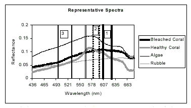
Figure 1. Representative spectra for four bottom types were identified using principal components analysis, and regions were identified to allow discrimination of bottom type based derivative analysis.
Because such high spectral resolution data is not available from a satellite platform at this time, equivalent medium resolution reflectance was calculated to simulate the expected SPOT HRV response. The in situ spectral dataset was investigated to determine the relationship between SPOT bands 1 (500-590nm) and 2 (610- 680nm). The measured reflectance values for SPOT band 1 and SPOT band 2 are highly correlated (multiple R = 0.853). Considering only SPOT band 1 reflectance (because of this strong association), the cross correlation coefficients for all substrate types are shown in Table 1. The correlation coefficients are generally small indicating a weak relationship between SPOT 1 reflectance and the 5 groups of substrate types. Only the correlation coefficient for rubble vs. sea grass (-0.73) is encouraging with respect to discrimination. Nevertheless, further examination of the coarse spectral resolution dataset is required to determine the extent to which identification and discrimination is possible on a SPOT image within a certain error range.
Table 1. Correlation coefficients of
SPOT1 reflectance values.
Variability Between Bottom Type Categories
Box plots are presented in Figure 2 to compare the variability between and within bottom type categories by year. The box plot for 1996A in Figure 2 reveals that there is greater variability in reflectance measurements in bleached coral measurements than the healthy coral and the algae values. The variability in bleached coral reflectance may be a result of different degrees of bleaching (i.e. different amounts of zooxanthellae present) such that some samples may have recently been placed under stress while others may have been bleached for some time and already imperceptibly colonized by macro algae. The differences in median reflectance in the 1996 dataset may be large enough to expect discrimination based on magnitude.
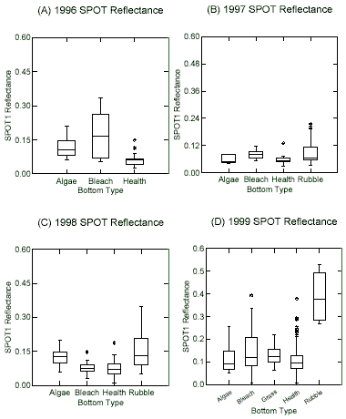
Figure 2. The above box plots compare the SPOT 1 simulated reflectance separately for each substrate group on a per year basis.
The variability within and between populations of bottom types is low in the 1997 dataset as seen in the box plot in Figure 2B. The spread is relatively large in the rubble category (n=35) possibly due to the presence of variable amounts of dead coral debris and rubble resulting in variable rubble reflectance measurements. For the 1997 data set, the median marks are similar between populations, rendering discrimination on the basis of magnitude of reflectance difficult.
As with the 1997 dataset, the variability within the rubble category (n=33) is considerably larger than the other bottom type categories in the 1998 box plot (Figure 2C). The median reflectance values for bleached and healthy corals are nearly identical with very similar spreads as well, which will therefore not enable discrimination based on SPOT 1 magnitude of reflectance. Likewise, median values for algae-covered surfaces and rubble are nearly identical, which would also render discrimination difficult.
Finally, the box plot for 1999 (Figure 2D) reveals that the reflectance values of rubble (n=10) are significantly higher than the other bottom type categories. These measurements suggest that the rubble sampled in 1999 was not as “contaminated” with debris and macro algae as the measurements in other years and at other locations. Unfortunately, the medians and spreads of reflectance values of the remaining bottom type categories are similar and would therefore be difficult to discern on this basis. It is worth noting that the healthy coral spectra have the “tightest” range indicating low variability within the population.
From this initial qualitative presentation and description of the variability between bottom types, it is apparent that it is unlikely that discrimination between substrate types could be accomplished simply using SPOT 1 magnitude of reflectance. There may be other means of discrimination, however, that would allow confident identification of broad categories of substrate type. The particular SPOT reflectance characteristics within each bottom type category will therefore be examined next.
Variability Within Bottom Type Categories
Constructing box plots to compare all measurements of a given category of bottom type collected from 1996 to 1999 allows further examination of SPOT 1 reflectance within the broad categories. Figure 3 contains box plots comparing healthy coral, bleached coral, rubble, algae covered surfaces, and grass separately including measurements taken from 1996 to 1999.
The median values of healthy coral are similar for all years, although the spread is the greatest in 1999 (n=10) (Figure 3A). Conversely, while the median values of bleached coral reflectance are similar in 1997 (n=17) and 1998 (n=30), the median values are considerably higher and the spread considerably greater in both 1996 (n=9) and 1999 (n=59) (Figure 3B). The median shown in the box plot for rubble shows relatively small variability in 1997 (n=35) and 1998 (n=33), but is considerably higher in 1999 (n=10) (Figure 3C).
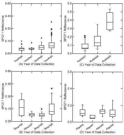
Figure 3. The above box plots compare the SPOT 1 simulated reflectance values for similar substrate types measured from 1996 to 1999.
The variability in magnitude of SPOT 1 reflectance is relatively small for the algae covered surfaces, although the spread is larger in 1996 (n=10), 1998 (n=76) and 1999 (n=14) than in 1997 (n=6) (Figure 3D). Finally, no comparison is possible of sea grass measurements between years/locations, but it is useful to examine the median and spread of reflectance values in sea grass measurements (n=24) collected in 1999 (Figure 3E). The box plots aid visualization of the variability within the bottom type populations, which appears to be qualitatively high.
Analysis of Variance
A statistical procedure for analyzing data with a quantitative dependent variable and a categorical independent variable, as is the case here, is analysis of variance (ANOVA). The variance of means is compared to the background variance of the data from which the means are determined. In the following one-way ANOVA, the null hypothesis of equal sample means is tested against the alternative hypothesis that each bottom type category comprises a separate population. ANOVA procedures compare differences in means such that within- and between-group variability are compared and referenced to the grand mean of the dataset.
An analysis of variance was performed on the entire dataset consisting of 596 SPOT 1 reflectance values (dependent variable) separated into 5 groups (healthy coral, bleached coral, algae, rubble and sea grass) with the null hypothesis that the means of all 5 groups are equal. In performing the ANOVA, the goal is to determine what part of the variance should be attributed to randomness and what part can be attributed to other factors. The Mean Square (MS) column reveals the sum of squares divided by the degrees of freedom, which indicates variance. The first value, 0.09, measures the variance between groups, while the second value, 0.00, measures the variance within groups. Since the variance between groups is larger than the variance within groups, then the average bottom reflectance is not the same for each group.
The F-value, 21.03, is the ratio of the two variances and is used to choose between the two hypotheses where the null hypothesis will be rejected if the F-ratio is in the upper 5% of the F distribution. The p-value is 0.00, which is less than the alpha value of 0.05 specified as the confidence level. The null hypothesis that the group means are equal must therefore be rejected at the 5% level. The calculated F-statistic, 21.03, is greater than the F-critical value, 2.39, indicating that the calculated F-statistic is in the upper 5% of the F-distribution. Therefore, although the qualitative assessment and comparison of population means suggested that there were no discernible differences, the statistical results of ANOVA suggest that the reflectance measurements were taken from 5 different or unique populations.
4. Conclusions
There is little qualitative difference between in situ reflectance values of various substrates collected at depth in a coral reef environment. This indicates that visual interpretation of remotely sensed imagery will yield inaccurate classification results. Significant mixing of several different substrate types within the relatively large pixels of SPOT HRV images (20x20m) compounds the issues of classification inaccuracy. Other complicating factors include the effects of attenuation and multiple scattering from the overlying water column, refraction of light at the air-water interface, scattering and absorption in the atmosphere, and effects of the variable morphology of the substrate with respect to slopes and self-shading.
The results of the statistical analysis of the simulated SPOT HRV reflectance values are encouraging since the populations can be considered significantly and sufficiently different to allow discrimination. While the populations defined for this study are admittedly broad, the categorization will still be useful for a change detection study of a large geographic region. Due to the natural variation of reflectance values both within and between populations, accurate and definite identification of substrate type may not be advisable especially considering the additional sources of error when the values are sensed remotely rather than in situ, as in this study. Alternatively, the fact that the in situ data reveals statistical separability between populations suggests that change detection is the most appropriate use of currently available satellite imagery.
Although the satellite imagery available has significant limitations in the accuracy and precision with which it can be used to map and monitor changes in coral reef ecosystems, the overt changes that are occurring warrant the use of the technology in an attempt to further our understanding of coral reefs. The currently available passive satellite imagery with appropriate spectral band locations (visible wavelengths for water penetration) should therefore be utilized to map the geographic extent of coral reefs and investigate changes in ecosystem health. The errors associated with the coarse spatial, spectral and temporal resolution should not be ignored, but rather, attempts should be made to minimize the associated errors and communicate the limitations of the digital image analysis results.
References
Abstract
Analysis of hyperspectral data has produced encouraging results in the discrimination of common and optically similar coral reef substrates such as healthy corals, bleached corals, sea grass, and algae-covered surfaces, but at the present time, such high spectral resolution data is unavailable from a satellite platform. If currently available satellite imagery is to be used to map and monitor changes in coral reef geographic extent and health, a quantitative procedure must be developed to discriminate healthy coral from other optically similar benthic substrates with coarse spectral resolution. The primary goal of this study is to evaluate the feasibility of using coarse spectral resolution data to map the geographic extent and monitor the changes in coral reef ecosystems. While previous studies have based analysis upon reflectance values extracted from images, an attempt is made here to discriminate common coral reef features using in situ spectral reflectance measurements with spectral resolution equivalent to SPOT HRV data. Results of a one-way analysis of variance suggest that the broad categories of in situ reflectance measurements (n=596) can be considered separate populations with respect to broadband reflectance characteristics.s
1. Introduction
Coral reef ecosystems are difficult and expensive to survey on a regular basis, so remote sensing is being explored as a feasible alternative to aerial photography and traditional ground survey techniques as a means of monitoring reef features (Hardy et al., 1992; Bour et al., 1986). Conventional methods of mapping the geographic extent of coral reefs rely on examination of nautical charts, aerial photography, and underwater observations, which are accomplished following a sampling methodology dependent on substrate type (Luczkovich et al., 1993; de Vel and Bour, 1990; Jupp et al., 1985). These conventional techniques may be sound if the area is small, but they are inadequate for large and/or inaccessible areas, so an alternative means of monitoring coral ecosystem health is required (Holden and LeDrew, 1998b).
Remote sensing is espoused as an ideal tool for resource management and ecosystem monitoring due to its ability to provide quantitative information quickly and relatively inexpensively compared to the cost of employing researchers to observe an equivalent area (Mumby et al., 1998; Hardy et al., 1992). While currently available satellite imagery has global mapping and monitoring capabilities, the accuracy and precision attainable is relatively low due to the large pixel size and broad spectral bandwidths of these sensors (Holden, 1999). Due to the urgency with which coral reef ecosystems need to be mapped and monitored (Wilkinson et al., 1999; Muller-Parker and D’Elia, 1997), waiting for the ideal technology for accurate and precise spatial, spectral, and temporal imaging of submerged coral reef ecosystems is not realistic. Instead, there is a need to utilize the available imaging technology, assess the accuracy and acknowledge the limitations.
The specific objectives of this paper are to examine the in situ spectral reflectance characteristics of common coral reef features such as algae-covered dead coral, bleached coral, and healthy coral to determine the degree to which they are discernible at spectral resolutions equivalent to SPOT HRV. We believe our approach based upon measured in situ spectral reflectance data and calculated SPOT HRV equivalent broadband reflectance data to be an effective means of identifying individual substrate types. This work is performed in anticipation of a project using an historical SPOT HRV data archive at the Centre for Remote Imaging, Sensing and Processing, National University of Singapore, to inspect and document the changes over time in coral reef geographic extent and health in the South China Sea.
2. Study Areas and Data Collection
Data collection has been on going since 1996 in the South Pacific, South East Asia and the Caribbean in an effort to create a global database of coral reef reflectance signatures. Field data collection took place in Beqa Lagoon, Fiji during July and August 1996, Manado, Sulawesi, Indonesia in July and August 1997, Savusavu Bay, Fiji in July and August 1998, and Buck Island National Monument, St. Croix, U.S. Virgin Islands in February 1999.
A hyperspectral radiometer (Analytical Spectral Devices Personal Spectrometer II) with a 20m underwater optical cable and an underwater cosine collector and 22 degree field of view foreoptics allowed reflectance measurements of submerged features while scuba diving. An underwater reference panel enabled determination of reflectance by measuring the nadir radiance of the reference panel immediately prior to each nadir radiance measurement of the feature of interest. The radiometer operator remained above water to take note of sky and water surface conditions and set the integration time. In an effort to reduce the noise factor within each measurement, five reflectance measurements were averaged automatically for each saved spectra. The water present between the radiometer foreoptic and the feature (10cm) is considered negligible, so no correction for attenuation was performed. Underwater photographs were taken of each of the features measured and notes were taken describing the depth, feature type, surrounding substrate, water quality, feature size and morphology as well as any other pertinent information.
In total, 596 spectral reflectance measurements are utilized in this study, each integrated to equal SPOT’s first two wavebands: (1) 500-590nm and (2) 610-680nm. Only the first two wavebands of the SPOT HRV are used here since light in the third band (790-890nm) is completely attenuated in the water column. The bottom type categories were assigned based on identification of the feature in the field and confirmed by inspection of the underwater photographic record. The broad categories are healthy coral (n=276), bleached coral (n=114), macro algae (n=105), rubble (n=77), and sea grass (n=24).
3. Spectral Data Analysis
The original measured spectra can be considered hyperspectral since they consist of 205 contiguous waveband channels with 1.4nm bandwidths. Previous analysis has shown that principal components analysis (PCA) enables reduction of the dataset to “representative” spectra for each of the broad bottom type categories defined: healthy coral; bleached coral; algae-covered surfaces; rubble; and seagrass (Holden and LeDrew, 1999; Myers et al., 1999). Discrimination of bottom type categories was successfully performed using spectral derivative analysis whereby the slope (first derivative) and change in slope (second derivative) of the spectral curves in specific wavelength regions was used as a discriminating variable (Holden and LeDrew, in press) and confirmed by (Myers et al., 1999) using an independent dataset. The wavelength regions allowing discrimination of bottom type with over 80% accuracy when applied to the entire spectral dataset (n=596) are shown in Figure 1. The spectral regions are numbered according to the order in which the derivative procedure follows such that the first derivative is found in region 1 (if positive slope, identify as rubble), then in region 2 (if positive slope, identify as bleached coral), and finally, second derivative is found in region 3 (if positive then identify as healthy coral) (Holden and LeDrew, in press).
Figure 1. Representative spectra for four bottom types were identified using principal components analysis, and regions were identified to allow discrimination of bottom type based derivative analysis.
Because such high spectral resolution data is not available from a satellite platform at this time, equivalent medium resolution reflectance was calculated to simulate the expected SPOT HRV response. The in situ spectral dataset was investigated to determine the relationship between SPOT bands 1 (500-590nm) and 2 (610- 680nm). The measured reflectance values for SPOT band 1 and SPOT band 2 are highly correlated (multiple R = 0.853). Considering only SPOT band 1 reflectance (because of this strong association), the cross correlation coefficients for all substrate types are shown in Table 1. The correlation coefficients are generally small indicating a weak relationship between SPOT 1 reflectance and the 5 groups of substrate types. Only the correlation coefficient for rubble vs. sea grass (-0.73) is encouraging with respect to discrimination. Nevertheless, further examination of the coarse spectral resolution dataset is required to determine the extent to which identification and discrimination is possible on a SPOT image within a certain error range.
| Grass | Rubble | Algae | Bleached | Healthy | |
| Grass | 1.00 | ||||
| Rubble | -0.73 | 1.00 | |||
| Algae | 0.09 | -0.38 | 1.00 | ||
| Bleached | 0.28 | -0.13 | 0.00 | 1.00 | |
| Healthy | -0.41 | 0.22 | -0.10 | 0.03 | 1.00 |
Variability Between Bottom Type Categories
Box plots are presented in Figure 2 to compare the variability between and within bottom type categories by year. The box plot for 1996A in Figure 2 reveals that there is greater variability in reflectance measurements in bleached coral measurements than the healthy coral and the algae values. The variability in bleached coral reflectance may be a result of different degrees of bleaching (i.e. different amounts of zooxanthellae present) such that some samples may have recently been placed under stress while others may have been bleached for some time and already imperceptibly colonized by macro algae. The differences in median reflectance in the 1996 dataset may be large enough to expect discrimination based on magnitude.
Figure 2. The above box plots compare the SPOT 1 simulated reflectance separately for each substrate group on a per year basis.
The variability within and between populations of bottom types is low in the 1997 dataset as seen in the box plot in Figure 2B. The spread is relatively large in the rubble category (n=35) possibly due to the presence of variable amounts of dead coral debris and rubble resulting in variable rubble reflectance measurements. For the 1997 data set, the median marks are similar between populations, rendering discrimination on the basis of magnitude of reflectance difficult.
As with the 1997 dataset, the variability within the rubble category (n=33) is considerably larger than the other bottom type categories in the 1998 box plot (Figure 2C). The median reflectance values for bleached and healthy corals are nearly identical with very similar spreads as well, which will therefore not enable discrimination based on SPOT 1 magnitude of reflectance. Likewise, median values for algae-covered surfaces and rubble are nearly identical, which would also render discrimination difficult.
Finally, the box plot for 1999 (Figure 2D) reveals that the reflectance values of rubble (n=10) are significantly higher than the other bottom type categories. These measurements suggest that the rubble sampled in 1999 was not as “contaminated” with debris and macro algae as the measurements in other years and at other locations. Unfortunately, the medians and spreads of reflectance values of the remaining bottom type categories are similar and would therefore be difficult to discern on this basis. It is worth noting that the healthy coral spectra have the “tightest” range indicating low variability within the population.
From this initial qualitative presentation and description of the variability between bottom types, it is apparent that it is unlikely that discrimination between substrate types could be accomplished simply using SPOT 1 magnitude of reflectance. There may be other means of discrimination, however, that would allow confident identification of broad categories of substrate type. The particular SPOT reflectance characteristics within each bottom type category will therefore be examined next.
Variability Within Bottom Type Categories
Constructing box plots to compare all measurements of a given category of bottom type collected from 1996 to 1999 allows further examination of SPOT 1 reflectance within the broad categories. Figure 3 contains box plots comparing healthy coral, bleached coral, rubble, algae covered surfaces, and grass separately including measurements taken from 1996 to 1999.
The median values of healthy coral are similar for all years, although the spread is the greatest in 1999 (n=10) (Figure 3A). Conversely, while the median values of bleached coral reflectance are similar in 1997 (n=17) and 1998 (n=30), the median values are considerably higher and the spread considerably greater in both 1996 (n=9) and 1999 (n=59) (Figure 3B). The median shown in the box plot for rubble shows relatively small variability in 1997 (n=35) and 1998 (n=33), but is considerably higher in 1999 (n=10) (Figure 3C).
Figure 3. The above box plots compare the SPOT 1 simulated reflectance values for similar substrate types measured from 1996 to 1999.
The variability in magnitude of SPOT 1 reflectance is relatively small for the algae covered surfaces, although the spread is larger in 1996 (n=10), 1998 (n=76) and 1999 (n=14) than in 1997 (n=6) (Figure 3D). Finally, no comparison is possible of sea grass measurements between years/locations, but it is useful to examine the median and spread of reflectance values in sea grass measurements (n=24) collected in 1999 (Figure 3E). The box plots aid visualization of the variability within the bottom type populations, which appears to be qualitatively high.
Analysis of Variance
A statistical procedure for analyzing data with a quantitative dependent variable and a categorical independent variable, as is the case here, is analysis of variance (ANOVA). The variance of means is compared to the background variance of the data from which the means are determined. In the following one-way ANOVA, the null hypothesis of equal sample means is tested against the alternative hypothesis that each bottom type category comprises a separate population. ANOVA procedures compare differences in means such that within- and between-group variability are compared and referenced to the grand mean of the dataset.
An analysis of variance was performed on the entire dataset consisting of 596 SPOT 1 reflectance values (dependent variable) separated into 5 groups (healthy coral, bleached coral, algae, rubble and sea grass) with the null hypothesis that the means of all 5 groups are equal. In performing the ANOVA, the goal is to determine what part of the variance should be attributed to randomness and what part can be attributed to other factors. The Mean Square (MS) column reveals the sum of squares divided by the degrees of freedom, which indicates variance. The first value, 0.09, measures the variance between groups, while the second value, 0.00, measures the variance within groups. Since the variance between groups is larger than the variance within groups, then the average bottom reflectance is not the same for each group.
The F-value, 21.03, is the ratio of the two variances and is used to choose between the two hypotheses where the null hypothesis will be rejected if the F-ratio is in the upper 5% of the F distribution. The p-value is 0.00, which is less than the alpha value of 0.05 specified as the confidence level. The null hypothesis that the group means are equal must therefore be rejected at the 5% level. The calculated F-statistic, 21.03, is greater than the F-critical value, 2.39, indicating that the calculated F-statistic is in the upper 5% of the F-distribution. Therefore, although the qualitative assessment and comparison of population means suggested that there were no discernible differences, the statistical results of ANOVA suggest that the reflectance measurements were taken from 5 different or unique populations.
4. Conclusions
There is little qualitative difference between in situ reflectance values of various substrates collected at depth in a coral reef environment. This indicates that visual interpretation of remotely sensed imagery will yield inaccurate classification results. Significant mixing of several different substrate types within the relatively large pixels of SPOT HRV images (20x20m) compounds the issues of classification inaccuracy. Other complicating factors include the effects of attenuation and multiple scattering from the overlying water column, refraction of light at the air-water interface, scattering and absorption in the atmosphere, and effects of the variable morphology of the substrate with respect to slopes and self-shading.
The results of the statistical analysis of the simulated SPOT HRV reflectance values are encouraging since the populations can be considered significantly and sufficiently different to allow discrimination. While the populations defined for this study are admittedly broad, the categorization will still be useful for a change detection study of a large geographic region. Due to the natural variation of reflectance values both within and between populations, accurate and definite identification of substrate type may not be advisable especially considering the additional sources of error when the values are sensed remotely rather than in situ, as in this study. Alternatively, the fact that the in situ data reveals statistical separability between populations suggests that change detection is the most appropriate use of currently available satellite imagery.
Although the satellite imagery available has significant limitations in the accuracy and precision with which it can be used to map and monitor changes in coral reef ecosystems, the overt changes that are occurring warrant the use of the technology in an attempt to further our understanding of coral reefs. The currently available passive satellite imagery with appropriate spectral band locations (visible wavelengths for water penetration) should therefore be utilized to map the geographic extent of coral reefs and investigate changes in ecosystem health. The errors associated with the coarse spatial, spectral and temporal resolution should not be ignored, but rather, attempts should be made to minimize the associated errors and communicate the limitations of the digital image analysis results.
References
- Bour, W., Loubersac, L. and Rual, P. 1986. Thematic mapping of reefs by processing of simulated SPOT satellite data: application to the Trochus niloticus biotope on Tetembia Reef (New Caledonia). Marine Ecology Progress Series. 34, 242-249.
- de Vel, O. and Bour, W. 1990. The Structural and Thematic Mapping of Coral Reefs Using High Resolution SPOT data: application to the Tetembia Reef, New Caledonia. Geocarto International, 2, 27-34.
- Hardy, J., Hoge F., Yungel, J. and Dodge, R. 1992. Remote Detection of coral Bleaching Using Pulsed-Laser Fluorescence Spectroscopy. Marine Ecology, 88, 247-255.
- Holden, H. 1999. An analysis of in situ observations of spectral reflectance characteristics of coral reef features in Fiji and Indonesia. Technical Report, Waterloo Laboratory for Earth Observations, University of Waterloo, Waterloo, Ontario, Canada, 206pp.
- Holden, H. and LeDrew, E. 1998a. Spectral discrimination of healthy and non-healthy corals based on cluster analysis, principal components analysis and derivative spectroscopy. Remote Sensing of Environment. 65, 217-224.
- Holden, H. and LeDrew E. 1998b. The scientific issues surrounding remote detection of submerged coral ecosystems. Progress in Physical Geography. 22 (2), 190-221.
- Holden, H. and LeDrew, E. In Press. Hyperspectral identification of coral reef features. International Journal of Remote Sensing.
- Jupp, D, K. Mayo, Kuchler, D., Claasen, D., Kenchington, R. and Guerin, P. 1985. Remote Sensing for Planning and Managing the Great Barrier Reef of Australia. Photogrammetria, 40, 21-42.
- Luczkovich, J., Wagner, T., Michalek J., and Stoffle R. 1993. Discrimination of coral reefs, seagrass and sand bottom types from space: a Dominican Republic case study. Photogrammetric Engineering and Remote Sensing. 59 (3), 385-389.
- Muller-Parker, G. and D’Elia, C. 1997. Interactions between corals and their symbiotic algae. In Life and Death of Coral Reefs. C. Birkeland (ed.). International Thompson Publishing: New York. 536 pages.
- Mumby, P., Green, E., Clark, C. and Edwards, A. 1998. Digital analysis of multispectral airborne imagery of coral reefs. Coral Reefs 17, 59-69.
- Myers, M., J. Hardy, C. Mazel, and P. Dustan. 1999. Optical spectra and pigmentation of Caribbean reef corals and macroalgae. Coral Reefs. 18, 179-186.
- Wilkinson, C., Linden, O., Cesar, H., Hodgson, G., Rubens J., and Strong, A. 1999. Ecological and socioeconomic impacts of 1998 coral mortality in the Indian Ocean: an ENSO impact and a warning of future change? Ambio. 28 (2), 188-196.