| GISdevelopment.net ---> AARS ---> ACRS 1999 ---> GIS |
Assessment of Map Cetainty on
Urban Growth using Remote Sensing and GIS Integration
Haja Andrianasolo, Duong
Quoc Nghi
Space Technology Applications and Research (STAR) Program
Asian Institute of Technology
P.O. Box 4, Klong Luang, Pathumthani 12120, Thailand
Tel.: (662)-5246109 Fax: (662)-52455
E-Mail:std78379@ait.ac.th
Space Technology Applications and Research (STAR) Program
Asian Institute of Technology
P.O. Box 4, Klong Luang, Pathumthani 12120, Thailand
Tel.: (662)-5246109 Fax: (662)-52455
E-Mail:std78379@ait.ac.th
Keyword: Urban Growth, Map Certainty,
Integration, Remote Sensing Data, Geographic Information System
Abstract
In planning for rapid urban growth process in Ha Noi City, local planners have to use the existing land use maps, which are often out-of-date, incomplete and inconsistent. In order to exact information for planning they should need to know how reliable these maps are. This paper selects the data integration method as a supportive tool such a purpose. The argument is that reliable land use mapping can be assessed from the convergence between changes recorded in the local mapping system and changes detected by remote sensing (RS) data. The integration method provides different solutions, from verifying map certainty to improving map quality and building spatial database. The case application shows the similarity as well as variations between the local maps and the comparative RS data on mapping the conversion of water surfaces into construction sites in Ha Noi.
1. Introduction
Since the launch of the reform policy, urban areas in Viet Nam have been developing rapidly. In Ha Noi city during the 1989-1998 period the population increased by a half and the area twice (see Table 1). The urban growth mainly consists of incorporation of urbanized settlements in the city fringe, and redevelopment of the old city areas.
Table 1. Urban Growth in Ha Noi City
Sources: * NIURP, 1992; ** VUTAP, 1995;*** HSO,
1998.
To plan and manage the rapid urban growth, local planners need reliable data on locations and features of urban activities. However such a need is rarely met because the existing spatial data, particularly the land use maps in Ha Noi City are often out-of-date, incomplete and standard varying (Nghi et al. 1999). Under the planned system, there was no land constraint to planning so these spatial data were not attended and adequately built. After reform the land has value and use constraint while planning and construction are booming. Various maps and plans produced by separate sectors have improved the spatial data but the map quality and quantity are still lacking. Thus the local planners have to secure all existing maps possible. They need effective method to assess the map certainty in order to get right information for use in planning work.
Mapping certainty refers to the accepted closeness of the mapped contents (position, attribute, representation model and lineage) to the real world phenomena. Assessment of the map certainty involves selection of relevant method and comparative data sources. Conventional field check is cost-intensive and time-consuming whereas the map overlay and data integration using secondary sources is relative fast and low-cost (Aggarwala et al., 1997). The integration method does not only transform different maps into common system for assessing overlap and gap but also solve their inconsistency for data integration (Nghi, 1999). The integration between RS and geographic information system (GIS) for spatial applications is gaining momentum recently. RS images offer complementary sources which are often classified and compared with the ground check and/or local maps for mapping “what is there and how much” (Stein et al., 1998) and for detecting changes of urban land-use features (Paulsson et al., 1995).
This paper assumes the integration approach to assessing the map certainty on urban growth. The argument is that reliability of urban growth mapping can be assessed through the convergence between the changes recorded by the local mapping system and the changes detected by RS data. After discussing the method the paper presents an application over a an area in the City of Ha Noi, Viet Nam where the comparative data are available.
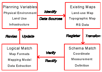
2. The Method
The procedure and supportive tools of the integration method could be seen in Figure 1. It does not only enable the assessment of data reliability in the first stage but also the data improvement in the subsequent stage. In the first step planner identifies the local maps, RS and supportive tools that would bring possible information needed and be relevant for the integration. In the second step the selected data are registered and transformed into a common system. This enables the third step to verify the map contents (theme, location and attributes) and to analyze map variations and solutions for improvement. After the third step new and accurate land use information could be extracted for update and use in planning. The method application needs a standard desktop GIS for data input and overlay, spreadsheet and geo-statistic programs for comparing the data aggregates.
Figure 1: Integration Method for Assessing Map Certainty
3. The Application
The application investigates the certainty of some local maps currently used in planning and management of Ha Noi. These local maps published in the early 1990s include the topographic maps of HSMC (1989) and of DMCD (1994) and the report by VUTAP (1995). The study area is the Lang Ha and Thanh Cong wards in the rapid urbanized fringe of Ha Noi City where the comparative RS products are available from Swedish Space Cooperation (SSC) project in Ha Noi. This product provided up-to-date information on changes of water surfaced areas during the 1979-1989 period (Paulsson et al., 1995). The question is if the local maps also describe such land use changes. The application only assesses the elevation element in the local maps. The tools used include Arc/Info for map transform and overlay, Excel and Surf for geo-statistic analysis and Mapinfo for display.
For integration, the selected maps are registered and transformed into the base system of the DMCD map. The VUTAP and SSC data are input (digitized and scanned) and interactively registered to the DMCD control points. The variation analysis uses map overlay. Figure 2 shows the elevation variation between the value of each DMCD elevation point and the averaged value of the HSMC elevation points, which fall within the 50m-radius buffer around such DMCD points.
Figure 2: Comparison of Elevation Data between DMCD Map and HSMC Map
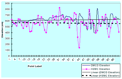
Source: DMCD, 1994; HSMC, 1989
These elevation variation is then interpolated into contour model demonstrating the increase trend of DMCD elevation values compared to those of the HSMC map as well as the data distortion due to the lack of DMCD data over water area. The composite map overlay on Figure 3 shows a considerable convergence of the selected data on the urban growth in the area. The elevation increase relatively match with the decreased water areas identified by the SSC data. Generally, the elevation contents in the local maps are reliable in describing the land leveling phenomena and its occurred area. Some uncertainties due to the time scale between RS data and the local maps, the lack of DMCD elevation value on water surface, the elevation modeling at 1:10,000 and 1:2,000 scale (point number and location), the rapid urban change when the maps were being produced, should be further investigated.

Figure 3: The Decreased Water Area and Elevation Increase in Lang Ha Thanh Cong
Source: HSMC, 1989; DMCD, 1994; Paulson st al, 1995.
4. Conclusion
The urban growth in developing countries like in Viet Nam is rapidly happening but the local maps are often uncertain for planner to plan for the process. The paper discusses the integration method using RS product and GIS tools for rapid assessment of the local maps. The application shows the ascertained map contents that could be used for further studying the urban growth pattern, the impact of water bodies reduction on open space and drainage, and the map inconsistencies for future improvement. The integration method demonstrates relative advantages by its low cost and flexible use of different data and tools. We believe that it will be useful and applicable by the local planner in assembling, verifying data certainty and successive data utilization in the planning process.
Reference from Journals:
Abstract
In planning for rapid urban growth process in Ha Noi City, local planners have to use the existing land use maps, which are often out-of-date, incomplete and inconsistent. In order to exact information for planning they should need to know how reliable these maps are. This paper selects the data integration method as a supportive tool such a purpose. The argument is that reliable land use mapping can be assessed from the convergence between changes recorded in the local mapping system and changes detected by remote sensing (RS) data. The integration method provides different solutions, from verifying map certainty to improving map quality and building spatial database. The case application shows the similarity as well as variations between the local maps and the comparative RS data on mapping the conversion of water surfaces into construction sites in Ha Noi.
1. Introduction
Since the launch of the reform policy, urban areas in Viet Nam have been developing rapidly. In Ha Noi city during the 1989-1998 period the population increased by a half and the area twice (see Table 1). The urban growth mainly consists of incorporation of urbanized settlements in the city fringe, and redevelopment of the old city areas.
Table 1. Urban Growth in Ha Noi City
| Urban components | 1989* | 1994** | 1998*** |
| Population (person) | 906,149 | 1,082,000 | 1,344,300 |
| Land (km2) | 43.00 | 47.57 | 82.78 |
To plan and manage the rapid urban growth, local planners need reliable data on locations and features of urban activities. However such a need is rarely met because the existing spatial data, particularly the land use maps in Ha Noi City are often out-of-date, incomplete and standard varying (Nghi et al. 1999). Under the planned system, there was no land constraint to planning so these spatial data were not attended and adequately built. After reform the land has value and use constraint while planning and construction are booming. Various maps and plans produced by separate sectors have improved the spatial data but the map quality and quantity are still lacking. Thus the local planners have to secure all existing maps possible. They need effective method to assess the map certainty in order to get right information for use in planning work.
Mapping certainty refers to the accepted closeness of the mapped contents (position, attribute, representation model and lineage) to the real world phenomena. Assessment of the map certainty involves selection of relevant method and comparative data sources. Conventional field check is cost-intensive and time-consuming whereas the map overlay and data integration using secondary sources is relative fast and low-cost (Aggarwala et al., 1997). The integration method does not only transform different maps into common system for assessing overlap and gap but also solve their inconsistency for data integration (Nghi, 1999). The integration between RS and geographic information system (GIS) for spatial applications is gaining momentum recently. RS images offer complementary sources which are often classified and compared with the ground check and/or local maps for mapping “what is there and how much” (Stein et al., 1998) and for detecting changes of urban land-use features (Paulsson et al., 1995).
This paper assumes the integration approach to assessing the map certainty on urban growth. The argument is that reliability of urban growth mapping can be assessed through the convergence between the changes recorded by the local mapping system and the changes detected by RS data. After discussing the method the paper presents an application over a an area in the City of Ha Noi, Viet Nam where the comparative data are available.
2. The Method
The procedure and supportive tools of the integration method could be seen in Figure 1. It does not only enable the assessment of data reliability in the first stage but also the data improvement in the subsequent stage. In the first step planner identifies the local maps, RS and supportive tools that would bring possible information needed and be relevant for the integration. In the second step the selected data are registered and transformed into a common system. This enables the third step to verify the map contents (theme, location and attributes) and to analyze map variations and solutions for improvement. After the third step new and accurate land use information could be extracted for update and use in planning. The method application needs a standard desktop GIS for data input and overlay, spreadsheet and geo-statistic programs for comparing the data aggregates.
Figure 1: Integration Method for Assessing Map Certainty
3. The Application
The application investigates the certainty of some local maps currently used in planning and management of Ha Noi. These local maps published in the early 1990s include the topographic maps of HSMC (1989) and of DMCD (1994) and the report by VUTAP (1995). The study area is the Lang Ha and Thanh Cong wards in the rapid urbanized fringe of Ha Noi City where the comparative RS products are available from Swedish Space Cooperation (SSC) project in Ha Noi. This product provided up-to-date information on changes of water surfaced areas during the 1979-1989 period (Paulsson et al., 1995). The question is if the local maps also describe such land use changes. The application only assesses the elevation element in the local maps. The tools used include Arc/Info for map transform and overlay, Excel and Surf for geo-statistic analysis and Mapinfo for display.
For integration, the selected maps are registered and transformed into the base system of the DMCD map. The VUTAP and SSC data are input (digitized and scanned) and interactively registered to the DMCD control points. The variation analysis uses map overlay. Figure 2 shows the elevation variation between the value of each DMCD elevation point and the averaged value of the HSMC elevation points, which fall within the 50m-radius buffer around such DMCD points.
Figure 2: Comparison of Elevation Data between DMCD Map and HSMC Map
Source: DMCD, 1994; HSMC, 1989
These elevation variation is then interpolated into contour model demonstrating the increase trend of DMCD elevation values compared to those of the HSMC map as well as the data distortion due to the lack of DMCD data over water area. The composite map overlay on Figure 3 shows a considerable convergence of the selected data on the urban growth in the area. The elevation increase relatively match with the decreased water areas identified by the SSC data. Generally, the elevation contents in the local maps are reliable in describing the land leveling phenomena and its occurred area. Some uncertainties due to the time scale between RS data and the local maps, the lack of DMCD elevation value on water surface, the elevation modeling at 1:10,000 and 1:2,000 scale (point number and location), the rapid urban change when the maps were being produced, should be further investigated.
Figure 3: The Decreased Water Area and Elevation Increase in Lang Ha Thanh Cong
Source: HSMC, 1989; DMCD, 1994; Paulson st al, 1995.
4. Conclusion
The urban growth in developing countries like in Viet Nam is rapidly happening but the local maps are often uncertain for planner to plan for the process. The paper discusses the integration method using RS product and GIS tools for rapid assessment of the local maps. The application shows the ascertained map contents that could be used for further studying the urban growth pattern, the impact of water bodies reduction on open space and drainage, and the map inconsistencies for future improvement. The integration method demonstrates relative advantages by its low cost and flexible use of different data and tools. We believe that it will be useful and applicable by the local planner in assembling, verifying data certainty and successive data utilization in the planning process.
Reference from Journals:
- Stein, W.G.M. Bastiaanssen, S. De Bruin, A.P. Cracknell, P.J. Curran, A.G. Fabbri, B.G.H. Gorte, J.W. van Groenigen, F.D. van De Meer, and A.Saldana, 1998. Integrating spatial statistics and remote sensing. International Journal of Remote Sensing, Vol. 19, No. 9, 1998, pp. 1793-1814.
- NIURP, 1992. Ha Noi Population Databook. National Institute for Urban and Rural Planning and United Nation Fund for Population Assistance (UNFPA), Ha Noi.
- HSO, 1998. 1998 Statistical Yearbook. Ha Noi Statistical Office.
- VUTAP, 1995. The Phuong of Ha Noi. First edition, The Viet Nam Urban Transport Assistance Project, Ha Noi.
- Aggarwala, Rajendra K., John D. Nystuen, Andrea I. Frank, and Jyothi Palathinkara, 1997. Using GIS to Evaluate the Quality of Digital Map Databases of Road Networks. Proceeding paper at Conference on Computer for Urban Planning and Urban Management CUPUM 1997 Bombay India pp. 493-502.
- DMCD, 1994. Ha Noi City 1:10,000 Scale Map. The Defense Ministry Cartographic Department, Ha Noi.
- HSMC, 1989. Dong Da District 1:2,000 Scale Map. The Ha Noi Survey and Mapping Company, Ha Noi.
- Nghi, Duong Quoc, 1999. Integrating Land-Related Information for Urban Planning and Management in Ha Noi City, Viet Nam, doctorate thesis progress report, Space Technology Research and Applications Program, Asian Institute of Technology, Bangkok, Thailand.
- Paulson B. and Ahcrona E., 1995. Monitoring Urban Growth in Developing Countries Through Satellite Remote Sensing. Final report, Swedish Space Corporation, Solna, Sweden.