| GISdevelopment.net ---> AARS ---> ACRS 1999 ---> GIS |
The Approaches and Practice
of Integrating GIS Software
Yan Li
Guangzhou Institute of Geography,Guangzhou,510070
Guobin Chi
Geographical department, South China Normal University,Guangzhou,510631
Qifang Liao
Guangzhou Institute of Geography,Guangzhou,510070
Pengde Li
Surveying and Mapping Bureau of Hainan, Haikou,570203
Guangzhou Institute of Geography,Guangzhou,510070
Guobin Chi
Geographical department, South China Normal University,Guangzhou,510631
Qifang Liao
Guangzhou Institute of Geography,Guangzhou,510070
Pengde Li
Surveying and Mapping Bureau of Hainan, Haikou,570203
Keyword Geographical Information; System
Integrating Method; GIS Software Integration
Abstract
Component integrating model was brought up for integrating GIS software based on component object model (COM) and Active X technique; The paper was also discussed the creating methods and major technical point of component integration and repeatable class objects; And finally, a clue and methods were furnished to the integrating GIS software with two case studies of Land Management Information System and Monitoring and Evaluating System of Coastal Reclaiming Lands.
1. Introduction
The information highway and “digital earth” plan has been becoming an actions of many governments in the world under the current tendency. The geographical information system (GIS) has its favorable developing circumstances and prospect as the wideness and the deepness of GIS applications are appeared a trend in changing with each passing day depending on the rapid development of computer development and great increasing of geo-information demands from society. But, the acquiring, storing, analyzing, processing and presenting results of geo-information need to be supported by GIS software. With the improving theory of GIS, and the founding and the developing of geomatics, GIS software platform was rapidly passed a developing procedure from GIS software packet to OpenGIS, WebGIS. As the diversity and the structure differentiae, various commercial GIS softwares are not compatible with each other. Due to the demands pushing forward the GIS software market, numerous function module were brought forth to the market by many well-known GIS software companies. The integrating issues are gradually becoming prominent between modular developed by users themselves and commercial ones, different commercial software, different modular but same commercial software. It is a “bottleneck” in applying GIS and GIS engineering construction.
There are usually two main integrating demands in developing applied geographical information systems (AGISs) and building geographical information Projects (GIPs). One is to create a friendly user interface, according to user’s requirements, by “inherent platforms” supporting with one of commercial GIS software. It was intensified some analyzing, processing, and output functions etc. and was developed to be a flexible and practical system; Another is integrated the superior components selected from various commercial GIS software in order to adapt the demands in building AGISs or GIPs. For the former one, it can not be satisfied to different user’s typical requirements like some simulating models etc. even if each of the commercial GIS software provided their own developing language or modular. And developed programs can not be adapted to each other and have no repeatibility to the other systems. Therefore, integrated techniques became a hot point with the GIS applications going on advance. This paper was discussed briefly the integrated issues through the experience.
II.Approaches to integrate the software
With the characteristics of geo-information being the regionalism, delamination, distribution, dynamic role and synthesis, it has been going into the departments of government and enterprises passed over geo-science but widely spatial information service through network. The main tendency of GIS applications is turned into the developing and integrating system according to the user’s demands with the support of GIS software.
The software integration can be divided into two aspects: data integration and components (functions) integration. Distributed database system and open database connection (ODBC)are furnished the significant approaches for relative attribute data; For spatial data, the data integration is mostly used the Import/Export for file exchange between different modular in a GIS or in various GISs. Object oriented technique and Component Object Model (COM), they are the technical fundament of integrated functions between the GIS software.
2.1 Component Object Model
Component object model (COM) is an object model of Client/Server and a standard form of processing interface between various components of the software and applying programs. According to the COM, a much more complicated and huge system can be set up by several components integration.
COM standard is included structure standard and Dynamic-Link Library (COMPOBJ.DLL) for executing. The first part is defined the mechanism of object creation and communication between objects; The second part is provided inner service of COMPOBJ.DLL. Communications between objects are implemented through COM connector that it keeps a logical and semantic relation with a function sets. Component object can not only be a client object but also be a server object. Even it can be both. COM is given a designing model of object oriented. The component integration is implemented through the models that they set up the complicated components and implement in coordination with software components in other systems.
2.2 Active X technique
The purpose of using object linking and embedding (OLE) technique is to integrate data from different applying programs or software easily and to coordinate the implementing simultaneously between client programs and server programs with friendly user interface. Automatic programming of OLE 2.0 allows the applying program detached from standard macro-language but using script completely or macro driving. The essence of OLE is the component software. The component, which developed by the other projects, controller or applying programs, do not have to redeveloping and just use them in the applying program. The combination of OLE and OLE controller techniques together were named Active X technique by Microsoft.
ActiveX is a component technique based on distributed COM. It can make operating each other between software components through network in spite of component programmed in different languages. And ActiveX is an assembly of Open techniques that it is provided a standard frame to create, to manage and to call the controllers based on the Object Oriented. Through the connector of events, methods, and attributes etc., it is interchanged with applied programs and built up an applied system which every GIS controller and non-GIS controller integrated easily with using visual develop tools.
Now, the component technique is a main current of GIS software development. For example, MapObjects, from ESRI, is provided 35 OLE (Object Linking & Embedding) objects. GeoMedia Professional, from INTERGRAPH, is provided 11 group and 30 controllers as programming objects. GeoMap, from GeoStar Information Project Company of Wuhan, is composed of one OLE controller and nearly 20 OLE Auto objects by using Windows developing environment. Hence, it is reasonable that to implement GIS software integrated method based on OLE/ActiveX component. Under the support of visualization development environment, any integrated target can be implemented by optimal composed of OLE/ActiveX. And for the typical functions, the Application Programming Interface (API) functions can also be integrated to it as repetitious class object composed.
2.3 Implementing approach of integration
The characteristics of GIS software integration are focused on the functions of graph and image processing, connecting between spatial data and related attribute data, and spatial analyzing etc. Hence, it is necessary to be supported by the visual developing environment for GIS software integration. At present, developing tools for integrating GIS applications are provided as follows: Visual Basic, Visual C++, Visual FoxPro and Delphi, Power Builder etc. The “component integration mode” is a major and important approach to implement integration. It means consisting of controllers provided by the environment and the commercial GIS software, and OLE automatic object based on integrating target.
During the procedure of component integrated, it is important to understand well about “event driving mechanism”. And it is used in the applying software and working mode of graphic user interface. To the different events, various controllers are prefabricated for graphic interface in visual developing environment. They are: window events, mouse events, and get or lose events etc. For every event of various objects, the system will be produced a corresponding information and passed it to the information response function or procedure. Because of the event driving mechanism, its controller right is given to the user and the system. It is not necessary to distinguish the user’s operation and to consider the control procedure of programming workflow but just to concentrate to execute the function of the system for the developer.
The technical procedure of GIS software integration is included in interface design, class module creation, and function development of API (Application Programming Interface). A design of multimedia interface is mainly focused on using MDI (Multiple Document Interface) technique and designing and organizing the menu and tool bar. Multitier menu is not only presented an optimizing organization but also user interface of event driving mechanism in visual integrating environment. Menu design is incarnated a technical style of the system designer and the deepness of his or her understanding to the user’s manipulating custom. The purpose of creating class module is mainly used to encapsulate program paragraph and made it repeatable and usable easily. Class module can be function module and also be repeatedly called program paragraph in the integrated system; at the same time, the class can be used to create ActiveX component in which it is defined by the class and the object is an instantiate of the class. Class module creation is included: setting, defining class attribute; writing a procedure of the class to create method and to give codes of the processing event. Actually, the class is encapsulated the attribute, method, and event to repeatable objects, and executed a specific function through creating object instantiate defined by it. But, all the controllers, which were provided by commercial GIS software and visual developing environment for integrating, are not properly satisfied the demands of function integration. Taking an example of Visual Basic, graphic function is its weakness. At this situation, API function needs to be called. Windows API is consisted of four function classes, they are windows management, interface of graphic device, system service and multimedia. API function can be called in any developing language in dynamic link library (DLL). Therefore, API function will be a reserving technique support to the component integration Model in implementing a certain target of software integration.
III. Practice of Component Integration
3.1 Integrated practice with selected commercial GIS software
The aim of GDLMIS (Guangdong Landuse Management Information System) construction is to store land information scientifically, to update the maps and document timely, and to have a good command of land resource and its utilization state in the whole province through querying. And the system is also needed to provide decision making support for land management, cultivated land protection and modern agricultural allocation etc. The major data sources were recent landuse maps and update maps with various scales 1:500,000 for province, 1:50,000 for cities and counties, and even more detail 1:25,000 in mountain area, 1:10,000 in agriculture area for the towns and valleys class. The system is also proposed to create updating landuse maps using multidisciplinary analysis and conclusion with remote sensing image, field inspecting data, and red line maps of the land owner etc. Various data sources. Hence, the characteristics of the system construction is large amount and various sources of data, and many models are needed in the system including RS (Remote Sensing) information processing, applying and decision making support model. As the result, a concept model of the integrating system was designed as follows in figure 1.
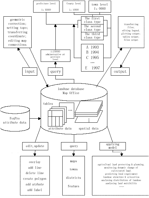
Fig. 1 A Concept Model of Integrated System for Guangdong Land Information Management System
3.1.1 Component integration
According to the aim of the system construction, its functions need to be included in strong graphic edit, systematic query and spatial analysis etc. It is necessary to furnish controllers and programmable objects as basic components under the support of OLE automation from modular commercial GIS software for creating user interface in the concept model of the system. The menu system of the user interface is a logic organization of all the functions in the integrated system. The multitier design of the menu system is not only considered the logic relationship between functions but also taken serious of logic relationship between controllers and programmable objects. The later one looks like a programming problem. Actually, it is an important factor that is given strong influence on reliability of the integrating system. Another important part of the user interface is tool bar which is presented the graphic shortcut of the common tools on the desktop for the system. In view of the module feature and such integrating object of tool bar provided from the commercial GIS software selected, Tool Bar Button in each module can be arranged into user interface. This feature makes the integrated system reflecting a much better flexibility.
As is known to all, there are no usable controllers and programmable objects in digital image processing functions. In this instance, OLE technique is used to insert the image processing module into the system and to implement its every function. At the same time, image processing module can be translated into Chinese partly, and made it properly coordinating with the interface of the system.
3.1.2 Class module creation
In general, user interface is a constructing procedure of component integration, and class module creation is really an implementing procedure of the system integration. A class is not contained programming groups of the control under Visual Basic integrating environment. Usually, class module is consisted of a few in common with programming procedures and functions. They create the methods of the class models. During implementing procedure of a method, an operation is called to executing or getting user’s response information from “container” – form with controller. And according to the different response event of the user, the event procedure is driven taking an example as clicking OK or clicking Cancel. In fact, user’s response information is a message assigned value to the variable and passed to the class module executing the task assuming responsibility of class module. For example, mod Record Sets is one of the frequently called modules. It contains two methods that one is created Record Set; another is recorded classified and statistical set. The method of creating Record Sets is called feature form selected and displayed the names of the database and the tables by user. After user selected, the “task” of the module is driven to open the operation of the database; if there is no related graph displaying the graphic window, a class module of graphic display is called to execute the graph displaying. Another example, mod Buffer Zone is a typical function module in which contains three methods; they are creating buffer zone, selecting distance of the buffer zone and getting coordinate information. Through calling the module, it is defined the center position of the buffer zone, calculated the exact distance based on the coordinate of projection and scale provided by the user, and finished the display of buffer zone position according to the selected point, arc or polygon.
3.2 Integrating approach with multiply commercial GIS software
The superior components integrated from various commercial GIS software are very important for the complicated systems. Here, an example was shown to explain the necessity and practical experience of it. A project, “Monitoring and evaluating reclaiming land system along the coastal line of Guangdong”, was assigned by the province government as an “government urgent task”. The project was proposed to investigate historical and recent situation of reclaiming land, to furnish the issues existed and to give the scientific suggestions and the solutions serving for the police making of the government along the coastal ling of 32 counties or cities in Guangdong. In order to finish it in two months, the system was executed the first stage which was focused on the investigating and presenting the results perfectly clear and correct. The system was set up in a “rough frame” structure by the end of last year. Later on, it will be depicted to a nicety system and completed to the aim of the project.
The information of the system were consisted of historical and recent investigating data of estuary, harbor, and coastal belt in county level; GPS data collected in the field; and comparison result from multiply temporal satellite images. The aim of the system is to make clear that the characteristics and the distribution of beach and estuary reclaimed, stone filled and fishing area etc. And actions and efficiency were evaluated for agricultural sustainable development. In view of the information features themselves and different GIS software and hardware used in implementing procedure, the system was based on the loose integrating scheme and executed the first attempt in software integration.
3.2.1 The main frame of the system integrated
Data integrating is a part of system integration. It is concentrated on the seamless integrating of attribute data of investigation, historical and recent graphical data, RS data and GPS data. The functions of the system were based on the GIS software. The data flow was structured the main framework of the system, and the Mapping Office from INTERGRAPH was selected for data acquiring to finish digitizing work of base map and set up a standard coordinate of the system. ARC/INFO, ERDAS Imagine, Arcview from ESRI, step by step, to process data editing and analyzing, image processing, and data and system integrating based on the previous works and present conditions of hardware and software. The user’s interface of the system was rebuilt with VB and VC++ etc as a supporting environment of developing tools. Finally, the system can used to process overlay with raster data and vector data, to decorate result with Chinese label and legend and publish a series of recent reclaiming area maps of 1. 500000 scale for whole province;1.50000 for emphasized regions. The practice was shown, suitable data exchanging format is one of the key points in various GIS software integration. Depending on the basic feature of GIS software, the system can be reached the objective and the accuracy if a proper data format selected.
The user interface was written by VB programming language, and its major function modules were included: statistic analysis of historical data, information recognition of RS images, multiply data sources overlay, and result decoration etc. Each module in the interface was applied the Shell function or OLE method to call related commercial GIS software or image processing software and to execute analyzing and processing. In the workflow, a geometric correction of digital image processing was based on the drainage network map combining with the GPS data measured in the field as main control point. A TIF format was confirmed to take for interactive image analyzing and recognition; the vector data interpreted was transferred into ARC/INFO with DXF format; after topological processing, it was passed to implement overlay and decoration in the function modules with E00 format and printed the maps. The result shown, the purposed objective was reached by this integrating framework, and got very good appraising from the government.
3.2.2 An attempt of API function developing
In order to present a direct and distinguished suffering state map of study area where river channels were narrowed and lengthened, silted up of shrink, areas of bay decreased and drain waterlogged ability reduced for these environmental damages analyzing from RS images. Therefore, a thematic mapping function module was developed to improve limitation of graphic function in VB depending on the Windows API function. It is satisfied the presentation demand for the project.
The function of this module was provided to drawing lines and polygons, filling patterns and colors, and graphic zoom on/off as an aided function of it. First of all, handle of Device Context should be got when a graph drawing is performed under VB environment. Calling GetDC API and getting form of HDC attribute, it is made drawing figures displayed on the form. The key point of drawing is obtained the position of polygon vertex, the line function assigned with x, and y coordinate is executed a drawn line function through calling GetCursorPos API function,. When a polygon drawn, a pen object of CreatePen API and a solid brush object of CreateSolidBrush API (or hatch brush object of CreateHatchBrush API) were set up first. Vertex data sets of polygon were obtained from GetCursorPos function, and they were passed to the polygon API function. After a filling mode was set up for the polygon with SetPolyFillMode API, the polygon was been drawing. It is presented a line drawing thematic map with RS image background, both overlap maps and individual one can be printed through implementing this module.
Applying result shown, this mapping module is quite flexible in filling patterns and colors to each polygon, and can also be used to do an interpretation on screen with RS images. The weak point of it is that the graph drawn is a raster format and still needs another software to vectorize it and makes the topological relations. Once more, this is only attempt function developing with API function and presented a clue and a method in software integration. A deepness and advanced integration is going to implement in the second stage.
IV. Conclusion
Object oriented technique and component object model is established a technical foundation for GIS software integration. It is a feasible method and technical approach to execute a “component integrated model” using visual developing environment, controllers provided by commercial GIS software and OLE automatic objects for integrating objective.
It is obviously advantage to the component integrated technique for applied system with GIS and RS. It will achieve the GIS software integrated into a new stage and make a great progress in applied GISs and in built GIPs based on developing and publishing ActiveX controller and repeatable class objects of DCOM.
References
Abstract
Component integrating model was brought up for integrating GIS software based on component object model (COM) and Active X technique; The paper was also discussed the creating methods and major technical point of component integration and repeatable class objects; And finally, a clue and methods were furnished to the integrating GIS software with two case studies of Land Management Information System and Monitoring and Evaluating System of Coastal Reclaiming Lands.
1. Introduction
The information highway and “digital earth” plan has been becoming an actions of many governments in the world under the current tendency. The geographical information system (GIS) has its favorable developing circumstances and prospect as the wideness and the deepness of GIS applications are appeared a trend in changing with each passing day depending on the rapid development of computer development and great increasing of geo-information demands from society. But, the acquiring, storing, analyzing, processing and presenting results of geo-information need to be supported by GIS software. With the improving theory of GIS, and the founding and the developing of geomatics, GIS software platform was rapidly passed a developing procedure from GIS software packet to OpenGIS, WebGIS. As the diversity and the structure differentiae, various commercial GIS softwares are not compatible with each other. Due to the demands pushing forward the GIS software market, numerous function module were brought forth to the market by many well-known GIS software companies. The integrating issues are gradually becoming prominent between modular developed by users themselves and commercial ones, different commercial software, different modular but same commercial software. It is a “bottleneck” in applying GIS and GIS engineering construction.
There are usually two main integrating demands in developing applied geographical information systems (AGISs) and building geographical information Projects (GIPs). One is to create a friendly user interface, according to user’s requirements, by “inherent platforms” supporting with one of commercial GIS software. It was intensified some analyzing, processing, and output functions etc. and was developed to be a flexible and practical system; Another is integrated the superior components selected from various commercial GIS software in order to adapt the demands in building AGISs or GIPs. For the former one, it can not be satisfied to different user’s typical requirements like some simulating models etc. even if each of the commercial GIS software provided their own developing language or modular. And developed programs can not be adapted to each other and have no repeatibility to the other systems. Therefore, integrated techniques became a hot point with the GIS applications going on advance. This paper was discussed briefly the integrated issues through the experience.
II.Approaches to integrate the software
With the characteristics of geo-information being the regionalism, delamination, distribution, dynamic role and synthesis, it has been going into the departments of government and enterprises passed over geo-science but widely spatial information service through network. The main tendency of GIS applications is turned into the developing and integrating system according to the user’s demands with the support of GIS software.
The software integration can be divided into two aspects: data integration and components (functions) integration. Distributed database system and open database connection (ODBC)are furnished the significant approaches for relative attribute data; For spatial data, the data integration is mostly used the Import/Export for file exchange between different modular in a GIS or in various GISs. Object oriented technique and Component Object Model (COM), they are the technical fundament of integrated functions between the GIS software.
2.1 Component Object Model
Component object model (COM) is an object model of Client/Server and a standard form of processing interface between various components of the software and applying programs. According to the COM, a much more complicated and huge system can be set up by several components integration.
COM standard is included structure standard and Dynamic-Link Library (COMPOBJ.DLL) for executing. The first part is defined the mechanism of object creation and communication between objects; The second part is provided inner service of COMPOBJ.DLL. Communications between objects are implemented through COM connector that it keeps a logical and semantic relation with a function sets. Component object can not only be a client object but also be a server object. Even it can be both. COM is given a designing model of object oriented. The component integration is implemented through the models that they set up the complicated components and implement in coordination with software components in other systems.
2.2 Active X technique
The purpose of using object linking and embedding (OLE) technique is to integrate data from different applying programs or software easily and to coordinate the implementing simultaneously between client programs and server programs with friendly user interface. Automatic programming of OLE 2.0 allows the applying program detached from standard macro-language but using script completely or macro driving. The essence of OLE is the component software. The component, which developed by the other projects, controller or applying programs, do not have to redeveloping and just use them in the applying program. The combination of OLE and OLE controller techniques together were named Active X technique by Microsoft.
ActiveX is a component technique based on distributed COM. It can make operating each other between software components through network in spite of component programmed in different languages. And ActiveX is an assembly of Open techniques that it is provided a standard frame to create, to manage and to call the controllers based on the Object Oriented. Through the connector of events, methods, and attributes etc., it is interchanged with applied programs and built up an applied system which every GIS controller and non-GIS controller integrated easily with using visual develop tools.
Now, the component technique is a main current of GIS software development. For example, MapObjects, from ESRI, is provided 35 OLE (Object Linking & Embedding) objects. GeoMedia Professional, from INTERGRAPH, is provided 11 group and 30 controllers as programming objects. GeoMap, from GeoStar Information Project Company of Wuhan, is composed of one OLE controller and nearly 20 OLE Auto objects by using Windows developing environment. Hence, it is reasonable that to implement GIS software integrated method based on OLE/ActiveX component. Under the support of visualization development environment, any integrated target can be implemented by optimal composed of OLE/ActiveX. And for the typical functions, the Application Programming Interface (API) functions can also be integrated to it as repetitious class object composed.
2.3 Implementing approach of integration
The characteristics of GIS software integration are focused on the functions of graph and image processing, connecting between spatial data and related attribute data, and spatial analyzing etc. Hence, it is necessary to be supported by the visual developing environment for GIS software integration. At present, developing tools for integrating GIS applications are provided as follows: Visual Basic, Visual C++, Visual FoxPro and Delphi, Power Builder etc. The “component integration mode” is a major and important approach to implement integration. It means consisting of controllers provided by the environment and the commercial GIS software, and OLE automatic object based on integrating target.
During the procedure of component integrated, it is important to understand well about “event driving mechanism”. And it is used in the applying software and working mode of graphic user interface. To the different events, various controllers are prefabricated for graphic interface in visual developing environment. They are: window events, mouse events, and get or lose events etc. For every event of various objects, the system will be produced a corresponding information and passed it to the information response function or procedure. Because of the event driving mechanism, its controller right is given to the user and the system. It is not necessary to distinguish the user’s operation and to consider the control procedure of programming workflow but just to concentrate to execute the function of the system for the developer.
The technical procedure of GIS software integration is included in interface design, class module creation, and function development of API (Application Programming Interface). A design of multimedia interface is mainly focused on using MDI (Multiple Document Interface) technique and designing and organizing the menu and tool bar. Multitier menu is not only presented an optimizing organization but also user interface of event driving mechanism in visual integrating environment. Menu design is incarnated a technical style of the system designer and the deepness of his or her understanding to the user’s manipulating custom. The purpose of creating class module is mainly used to encapsulate program paragraph and made it repeatable and usable easily. Class module can be function module and also be repeatedly called program paragraph in the integrated system; at the same time, the class can be used to create ActiveX component in which it is defined by the class and the object is an instantiate of the class. Class module creation is included: setting, defining class attribute; writing a procedure of the class to create method and to give codes of the processing event. Actually, the class is encapsulated the attribute, method, and event to repeatable objects, and executed a specific function through creating object instantiate defined by it. But, all the controllers, which were provided by commercial GIS software and visual developing environment for integrating, are not properly satisfied the demands of function integration. Taking an example of Visual Basic, graphic function is its weakness. At this situation, API function needs to be called. Windows API is consisted of four function classes, they are windows management, interface of graphic device, system service and multimedia. API function can be called in any developing language in dynamic link library (DLL). Therefore, API function will be a reserving technique support to the component integration Model in implementing a certain target of software integration.
III. Practice of Component Integration
3.1 Integrated practice with selected commercial GIS software
The aim of GDLMIS (Guangdong Landuse Management Information System) construction is to store land information scientifically, to update the maps and document timely, and to have a good command of land resource and its utilization state in the whole province through querying. And the system is also needed to provide decision making support for land management, cultivated land protection and modern agricultural allocation etc. The major data sources were recent landuse maps and update maps with various scales 1:500,000 for province, 1:50,000 for cities and counties, and even more detail 1:25,000 in mountain area, 1:10,000 in agriculture area for the towns and valleys class. The system is also proposed to create updating landuse maps using multidisciplinary analysis and conclusion with remote sensing image, field inspecting data, and red line maps of the land owner etc. Various data sources. Hence, the characteristics of the system construction is large amount and various sources of data, and many models are needed in the system including RS (Remote Sensing) information processing, applying and decision making support model. As the result, a concept model of the integrating system was designed as follows in figure 1.
Fig. 1 A Concept Model of Integrated System for Guangdong Land Information Management System
3.1.1 Component integration
According to the aim of the system construction, its functions need to be included in strong graphic edit, systematic query and spatial analysis etc. It is necessary to furnish controllers and programmable objects as basic components under the support of OLE automation from modular commercial GIS software for creating user interface in the concept model of the system. The menu system of the user interface is a logic organization of all the functions in the integrated system. The multitier design of the menu system is not only considered the logic relationship between functions but also taken serious of logic relationship between controllers and programmable objects. The later one looks like a programming problem. Actually, it is an important factor that is given strong influence on reliability of the integrating system. Another important part of the user interface is tool bar which is presented the graphic shortcut of the common tools on the desktop for the system. In view of the module feature and such integrating object of tool bar provided from the commercial GIS software selected, Tool Bar Button in each module can be arranged into user interface. This feature makes the integrated system reflecting a much better flexibility.
As is known to all, there are no usable controllers and programmable objects in digital image processing functions. In this instance, OLE technique is used to insert the image processing module into the system and to implement its every function. At the same time, image processing module can be translated into Chinese partly, and made it properly coordinating with the interface of the system.
3.1.2 Class module creation
In general, user interface is a constructing procedure of component integration, and class module creation is really an implementing procedure of the system integration. A class is not contained programming groups of the control under Visual Basic integrating environment. Usually, class module is consisted of a few in common with programming procedures and functions. They create the methods of the class models. During implementing procedure of a method, an operation is called to executing or getting user’s response information from “container” – form with controller. And according to the different response event of the user, the event procedure is driven taking an example as clicking OK or clicking Cancel. In fact, user’s response information is a message assigned value to the variable and passed to the class module executing the task assuming responsibility of class module. For example, mod Record Sets is one of the frequently called modules. It contains two methods that one is created Record Set; another is recorded classified and statistical set. The method of creating Record Sets is called feature form selected and displayed the names of the database and the tables by user. After user selected, the “task” of the module is driven to open the operation of the database; if there is no related graph displaying the graphic window, a class module of graphic display is called to execute the graph displaying. Another example, mod Buffer Zone is a typical function module in which contains three methods; they are creating buffer zone, selecting distance of the buffer zone and getting coordinate information. Through calling the module, it is defined the center position of the buffer zone, calculated the exact distance based on the coordinate of projection and scale provided by the user, and finished the display of buffer zone position according to the selected point, arc or polygon.
3.2 Integrating approach with multiply commercial GIS software
The superior components integrated from various commercial GIS software are very important for the complicated systems. Here, an example was shown to explain the necessity and practical experience of it. A project, “Monitoring and evaluating reclaiming land system along the coastal line of Guangdong”, was assigned by the province government as an “government urgent task”. The project was proposed to investigate historical and recent situation of reclaiming land, to furnish the issues existed and to give the scientific suggestions and the solutions serving for the police making of the government along the coastal ling of 32 counties or cities in Guangdong. In order to finish it in two months, the system was executed the first stage which was focused on the investigating and presenting the results perfectly clear and correct. The system was set up in a “rough frame” structure by the end of last year. Later on, it will be depicted to a nicety system and completed to the aim of the project.
The information of the system were consisted of historical and recent investigating data of estuary, harbor, and coastal belt in county level; GPS data collected in the field; and comparison result from multiply temporal satellite images. The aim of the system is to make clear that the characteristics and the distribution of beach and estuary reclaimed, stone filled and fishing area etc. And actions and efficiency were evaluated for agricultural sustainable development. In view of the information features themselves and different GIS software and hardware used in implementing procedure, the system was based on the loose integrating scheme and executed the first attempt in software integration.
3.2.1 The main frame of the system integrated
Data integrating is a part of system integration. It is concentrated on the seamless integrating of attribute data of investigation, historical and recent graphical data, RS data and GPS data. The functions of the system were based on the GIS software. The data flow was structured the main framework of the system, and the Mapping Office from INTERGRAPH was selected for data acquiring to finish digitizing work of base map and set up a standard coordinate of the system. ARC/INFO, ERDAS Imagine, Arcview from ESRI, step by step, to process data editing and analyzing, image processing, and data and system integrating based on the previous works and present conditions of hardware and software. The user’s interface of the system was rebuilt with VB and VC++ etc as a supporting environment of developing tools. Finally, the system can used to process overlay with raster data and vector data, to decorate result with Chinese label and legend and publish a series of recent reclaiming area maps of 1. 500000 scale for whole province;1.50000 for emphasized regions. The practice was shown, suitable data exchanging format is one of the key points in various GIS software integration. Depending on the basic feature of GIS software, the system can be reached the objective and the accuracy if a proper data format selected.
The user interface was written by VB programming language, and its major function modules were included: statistic analysis of historical data, information recognition of RS images, multiply data sources overlay, and result decoration etc. Each module in the interface was applied the Shell function or OLE method to call related commercial GIS software or image processing software and to execute analyzing and processing. In the workflow, a geometric correction of digital image processing was based on the drainage network map combining with the GPS data measured in the field as main control point. A TIF format was confirmed to take for interactive image analyzing and recognition; the vector data interpreted was transferred into ARC/INFO with DXF format; after topological processing, it was passed to implement overlay and decoration in the function modules with E00 format and printed the maps. The result shown, the purposed objective was reached by this integrating framework, and got very good appraising from the government.
3.2.2 An attempt of API function developing
In order to present a direct and distinguished suffering state map of study area where river channels were narrowed and lengthened, silted up of shrink, areas of bay decreased and drain waterlogged ability reduced for these environmental damages analyzing from RS images. Therefore, a thematic mapping function module was developed to improve limitation of graphic function in VB depending on the Windows API function. It is satisfied the presentation demand for the project.
The function of this module was provided to drawing lines and polygons, filling patterns and colors, and graphic zoom on/off as an aided function of it. First of all, handle of Device Context should be got when a graph drawing is performed under VB environment. Calling GetDC API and getting form of HDC attribute, it is made drawing figures displayed on the form. The key point of drawing is obtained the position of polygon vertex, the line function assigned with x, and y coordinate is executed a drawn line function through calling GetCursorPos API function,. When a polygon drawn, a pen object of CreatePen API and a solid brush object of CreateSolidBrush API (or hatch brush object of CreateHatchBrush API) were set up first. Vertex data sets of polygon were obtained from GetCursorPos function, and they were passed to the polygon API function. After a filling mode was set up for the polygon with SetPolyFillMode API, the polygon was been drawing. It is presented a line drawing thematic map with RS image background, both overlap maps and individual one can be printed through implementing this module.
Applying result shown, this mapping module is quite flexible in filling patterns and colors to each polygon, and can also be used to do an interpretation on screen with RS images. The weak point of it is that the graph drawn is a raster format and still needs another software to vectorize it and makes the topological relations. Once more, this is only attempt function developing with API function and presented a clue and a method in software integration. A deepness and advanced integration is going to implement in the second stage.
IV. Conclusion
Object oriented technique and component object model is established a technical foundation for GIS software integration. It is a feasible method and technical approach to execute a “component integrated model” using visual developing environment, controllers provided by commercial GIS software and OLE automatic objects for integrating objective.
It is obviously advantage to the component integrated technique for applied system with GIS and RS. It will achieve the GIS software integrated into a new stage and make a great progress in applied GISs and in built GIPs based on developing and publishing ActiveX controller and repeatable class objects of DCOM.
References
- Jianting Zhang and Weiguo Liu, A study in software system structured of GIS engineering, Techniques and Applications of Remote Sensing, 1998, 16(3):54-59.
- Brian Farrar, translated by Xiaodan Liu, User’ Guide of Active X, Engine Press, 1997.
- Bryan Waters, translated by Yujie He etc., Start and Develop of OLE2, Electronic Press,1996.
- Daqiang Yang, Nan Jiang and Heping Xi, GIS Component based on Active X Technique, Computer Application, 1998, 18(11): 30-32.
- Yadan Zhao, advanced developing tools and environment for MIS development, Applications of Computer System, 1998, 15(7): 8-10.