| GISdevelopment.net ---> AARS ---> ACRS 1999 ---> GIS |
Remote Sensing and GIS for
Flood Prediction
Rohaya Mamat & Shattri
B. Mansor
Dept. of Civil Engineering, Faculty of Engineering,
Universiti Putra Malaysia,43300 Serdang, Selangor, Malaysia.
Tel: 03-9486101 ext 2067, Fax: 603-9488939
E-Mail:shattri@eng.upm.edu.my
Dept. of Civil Engineering, Faculty of Engineering,
Universiti Putra Malaysia,43300 Serdang, Selangor, Malaysia.
Tel: 03-9486101 ext 2067, Fax: 603-9488939
E-Mail:shattri@eng.upm.edu.my
Keuwords: ACRS, Flood Prediction, DEM, SCS
TR-55, GIS, Remote Sensing.
Abstract Flooding has been the most life and properties threatening disaster especially in a big urbanized country like Kuala Lumpur. Changes of land-use pattern have been the major contributing factor of effect. This paper will discussed on the study of flood problem using the Remote Sensing and GIS technology for flood prediction in Klang Valley (Kuala Lumpur). Digital elevation Model (DEM) was produced from interpolation of contour heights at interval of 20 meter from 1:50,000 topographical map. The river basin region was then delineate into smaller subwatershed which later used in the hydrologic design modelling. Flood inundation are predicted using the Graphical Method of Soil Conservation Service Technical Release 55 (SCS TR-55) model which defined the peak discharge and Stage - discharge rating curve are use to correlate the predicted peak discharge with the height of water level directly measure from the field at the concerned 4 river-gauge stations. The calculation of peak discharge involves the calculation of Runoff Curve Number (CN) method that relates to land use pattern of study area. Aspect of landuse pattern are derived from the SPOT-XS image. Rainfall data are used as the input data.
1.0 Introduction
The Klang river basin is located towards the west coast of Peninsular Malaysia, in the central part of Selangor State. The basin consist of most urbanized and still rapidly urbanizing regions including the nation's Capital of Kuala Lumpur. Increase in urbanizing may result in increment of sedimentation and pollution. Even though there's a lot of mitigation projects have been done, the problem of flooding still remain as one of the most frequent and devastating natural hazards to this area.
Flood is among the most common and widespread natural hazard phenomena causing billions of dollars in damage each year. Changes in land use pattern especially development from the rural area to the urban area have become one of the major cause. According to JICA(1989), there are two causes of flooding that is depression-type monsoon storm and thunderstorm. The main focus of study is the thunderstorm flooding also known as flash flood, that might cause more damages to the civilization. Because of its high intensity, localized and short duration (3-5 hrs) characteristic flood event, it's study become more important especially in flood forecasting. The localized occurrence of flooding aspect makes it easier to locate the flood prone areas.
Remote sensing and GIS are used widely especially in the disaster related assessment because there is a need for more timely and detail information of the location, area and extent of the damage from a disaster to aid in response and recovery activities. Remotely sensed data are the most suitable approach since site investigation become almost impossible to manage during flood event.
This paper will discussed on the use of DEM and the SPOT image data to derived the parameter used in U.S. Soil Conservation Service Technical Release 55 (SCS TR55) hydrological model in prediction of floods by determining river stage at the 4 chosen river station.
2.0 Digital Elevation Model
DEM can be created by collecting elevations and referencing them to the corresponding points in the mapped area. Digital contour lines digitised from the topographic map is the main source of the DEM generation. Two main steps followed in constructing DEM. The first step is converting contour data containing elevation attribute into the point data. The second step will generates the surface from the point data created in the first step. The triangulated irregular network (TIN) are applied in this process. The topographical map of 1:50 000 scaled (1991) with 20m interval are used.
Information may be extracted in two ways, by visual analysis of graphic representation or by quantitative analysis of digital elevation data. The DEM will provide automatic layers for perspective viewing, slope analysis, terrain analysis, hydrography analysis and flood simulation.
3.0 Subwatershed Delineation
For the purpose of hydrologic design modelling, subdividing the watershed is often necessary. As being described by Mc Cuen (1998), the boundary of a watershed is defined by all points that will shed water to the outlet. Water will travel perpendicular to the elevation contour, which is the direction that maximizes the slopes. In this method, DEM are used instead of using contour line.
To qualify the needs of Graphical Peak Discharge Method, the study area is delineated into small homogenous subwatersheds (Figure1).
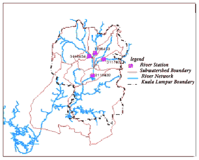
Figure 1: This Map Showing The Correspond Subwatershed and River Station in The Study Area.
4.0 Satellite Data Processing
Geometric Correction
The SPOT-XS image (April, 24 1998) was rectified to RSO grid projection using the ground control point (GCP). The mathematical model used here is polynomial and 20 control points are chosen from the topographical map of the study area for source of GCP using the user entered method.
Image Classification
The process of image classification was carried out to classify the landuse pattern at the surrounding area of 4 stated river station. The supervised classification technique was used. The training areas are localized and identified using the topographic map (1991) of Kuala Lumpur. The homogenous area defined at the four river station are all the urbanized area with lots of parking lots and residential areas with CN is 85.
5.0 Hydrological Modelling
The SCS TR55 Model (USDA, 1986) presents the simplified procedures for estimating runoff and peak discharges in small watershed. It gives the emphasizing procedures to urban and urbanizing watersheds.
There are two method adopted from this model namely 1) Runoff Curve Number Method and 2) Graphical Peak Discharge Method.
5.1 Runoff Curve Number Method
Detailed on the NRCS Runoff Curve Number (CN) method is described in NEH-4 (SCS 1985). The equation is;
Q = ((P-Ia)^2)/((P-Ia)+S) [eq. 5-1]
Where
Q = runoff (in)
P = rainfall
S = potential maximum retention after runoff begins (in) = (1000 / CN) - 10
Ia = initial abstraction (in) = 0.2 S
from [eq. 5-1], by substituting Ia = 0.2 S;
Q = (( P - 0.2 S )^ 2) / (( P + 0.8 S ) [eq. 5-2]
5.2 Graphical Peak Discharge Method.
To estimate the peak discharge, firstly we need to have the information on the time of concentration and the travel time required by the water to flow from the distance point to the outlet.
5.2.1 Time of Concentration
To obtain the time of concentration;
Tc = Tt1 + Tt2 + .....+ Ttm [eq. 5-3]
Tt = L / 3600 V [eq. 5-4]
where:
Tc/Tt = time of concentration (hr) / travel time (hr)
m = number of flow segments
L = flow length (ft)
V = average velocity (ft/s)
3600 = conversion factor from seconds to hours.
For open channel flow velocity calculation, Manning’s equation are used;
V = ( 1.49 * r (2/3) * s(1/2)) / n [eq. 5-5]
where:
V = average velocity (ft/s)
r = hydraulic radius (ft) and is equal to a/pw
a = cross sectional flow area (ft2)
Pw = wetted perimeter (ft)
s = slope of the hydraulic grade line (channel slope, ft/ft)
n = Manning’s roughness coefficient for open channel flow.
5.2.3 Graphical Peak Discharge Method
The peak discharge equation used is;
qp = quAmQFp [eq. 5-6]
and log (qu) = C0 + C1 log(Tc) + C2[(log(qu)]2 [eq. 5-7]
where:
qp = peak discharge (ft3 /s)
qu = unit peak discharge (csm/in)
Am = drainage area (mi2)
Q = runoff (in)
Fp = pond and adjustment factor =1
Tc = time of concentration (hr)
C0, C1, C2 = Coefficients
5.3 Stage - Discharge rating curve
The stage - discharge rating curve are used to define the relationship between the water level and water discharge for appropriate river stage. This formula relates the discharge and the stage of water level which is commonly use (water level) by Malaysian Government as the risk level indicator.
The formulae;
q = a * hb [eq. 5-8]
where
q = discharge (m3 /s)
h = the water level (m)
a & b = constant = 2.7542 & 1.4667 respectively
From equation [5-8],
log q = log a + b log h [eq. 5-9]
equation [eq. 5-9] are the linear equation and gives the straight line rating curve (figure2) which will gives the value for a and b. With the value of a and b, and the value of discharge, we can get the water level observed at the field defining the risk level.
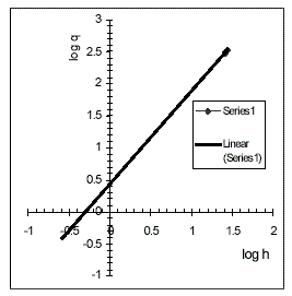
Figure 2: The Stage Discharge Rating Curve.
All the calculations are tabulated in table 1. For an example of calculation, 6 in 24-hour rainfall are used which gives the difference of water level due to each river station’s profile.
Table 1: The TR55 Flood Prediction Calculation
6.0 Conclusion
The preliminary analysis of TR55 model as the flood prediction model is an applicable model for the urbanizing watershed (USDA, 1986) like Kuala Lumpur, Malaysia. The use of DEM which is available task in almost GIS software packages is helpful in defining the homogenous area for the need of Graphical Method in this study. Changes of land use pattern can be easily monitored by using the satellite image.
The hydrological model used here is based on the soil type of United States and the suitability of this model apply to Malaysian environment is still uncertain. Further investigation must be done to study the rationale of this model before it is applicable to the real situation.
It can be concluded that the integration of remote sensing and GIS techniques is undoubtedly very useful in the flood prediction investigation. In the case of disaster management, it is a must to show the area of influenced with the specifically spatial information so as early action can be taken to reduce the damages and the important is lives.
Acknowledgements The authors wish to thank the Department of Irrigation and Drainage (DID), Ampang Branch, Malaysia for providing the rainfall and river discharge data, the Dept. of Survey and Mapping (JUPEM), Malaysia for the information on geographical data and also Malaysia Center Of Remote Sensing (MACRES), Malaysia for Satellite Image.
References
Abstract Flooding has been the most life and properties threatening disaster especially in a big urbanized country like Kuala Lumpur. Changes of land-use pattern have been the major contributing factor of effect. This paper will discussed on the study of flood problem using the Remote Sensing and GIS technology for flood prediction in Klang Valley (Kuala Lumpur). Digital elevation Model (DEM) was produced from interpolation of contour heights at interval of 20 meter from 1:50,000 topographical map. The river basin region was then delineate into smaller subwatershed which later used in the hydrologic design modelling. Flood inundation are predicted using the Graphical Method of Soil Conservation Service Technical Release 55 (SCS TR-55) model which defined the peak discharge and Stage - discharge rating curve are use to correlate the predicted peak discharge with the height of water level directly measure from the field at the concerned 4 river-gauge stations. The calculation of peak discharge involves the calculation of Runoff Curve Number (CN) method that relates to land use pattern of study area. Aspect of landuse pattern are derived from the SPOT-XS image. Rainfall data are used as the input data.
1.0 Introduction
The Klang river basin is located towards the west coast of Peninsular Malaysia, in the central part of Selangor State. The basin consist of most urbanized and still rapidly urbanizing regions including the nation's Capital of Kuala Lumpur. Increase in urbanizing may result in increment of sedimentation and pollution. Even though there's a lot of mitigation projects have been done, the problem of flooding still remain as one of the most frequent and devastating natural hazards to this area.
Flood is among the most common and widespread natural hazard phenomena causing billions of dollars in damage each year. Changes in land use pattern especially development from the rural area to the urban area have become one of the major cause. According to JICA(1989), there are two causes of flooding that is depression-type monsoon storm and thunderstorm. The main focus of study is the thunderstorm flooding also known as flash flood, that might cause more damages to the civilization. Because of its high intensity, localized and short duration (3-5 hrs) characteristic flood event, it's study become more important especially in flood forecasting. The localized occurrence of flooding aspect makes it easier to locate the flood prone areas.
Remote sensing and GIS are used widely especially in the disaster related assessment because there is a need for more timely and detail information of the location, area and extent of the damage from a disaster to aid in response and recovery activities. Remotely sensed data are the most suitable approach since site investigation become almost impossible to manage during flood event.
This paper will discussed on the use of DEM and the SPOT image data to derived the parameter used in U.S. Soil Conservation Service Technical Release 55 (SCS TR55) hydrological model in prediction of floods by determining river stage at the 4 chosen river station.
2.0 Digital Elevation Model
DEM can be created by collecting elevations and referencing them to the corresponding points in the mapped area. Digital contour lines digitised from the topographic map is the main source of the DEM generation. Two main steps followed in constructing DEM. The first step is converting contour data containing elevation attribute into the point data. The second step will generates the surface from the point data created in the first step. The triangulated irregular network (TIN) are applied in this process. The topographical map of 1:50 000 scaled (1991) with 20m interval are used.
Information may be extracted in two ways, by visual analysis of graphic representation or by quantitative analysis of digital elevation data. The DEM will provide automatic layers for perspective viewing, slope analysis, terrain analysis, hydrography analysis and flood simulation.
3.0 Subwatershed Delineation
For the purpose of hydrologic design modelling, subdividing the watershed is often necessary. As being described by Mc Cuen (1998), the boundary of a watershed is defined by all points that will shed water to the outlet. Water will travel perpendicular to the elevation contour, which is the direction that maximizes the slopes. In this method, DEM are used instead of using contour line.
To qualify the needs of Graphical Peak Discharge Method, the study area is delineated into small homogenous subwatersheds (Figure1).
Figure 1: This Map Showing The Correspond Subwatershed and River Station in The Study Area.
4.0 Satellite Data Processing
Geometric Correction
The SPOT-XS image (April, 24 1998) was rectified to RSO grid projection using the ground control point (GCP). The mathematical model used here is polynomial and 20 control points are chosen from the topographical map of the study area for source of GCP using the user entered method.
Image Classification
The process of image classification was carried out to classify the landuse pattern at the surrounding area of 4 stated river station. The supervised classification technique was used. The training areas are localized and identified using the topographic map (1991) of Kuala Lumpur. The homogenous area defined at the four river station are all the urbanized area with lots of parking lots and residential areas with CN is 85.
5.0 Hydrological Modelling
The SCS TR55 Model (USDA, 1986) presents the simplified procedures for estimating runoff and peak discharges in small watershed. It gives the emphasizing procedures to urban and urbanizing watersheds.
There are two method adopted from this model namely 1) Runoff Curve Number Method and 2) Graphical Peak Discharge Method.
5.1 Runoff Curve Number Method
Detailed on the NRCS Runoff Curve Number (CN) method is described in NEH-4 (SCS 1985). The equation is;
Q = ((P-Ia)^2)/((P-Ia)+S) [eq. 5-1]
Where
Q = runoff (in)
P = rainfall
S = potential maximum retention after runoff begins (in) = (1000 / CN) - 10
Ia = initial abstraction (in) = 0.2 S
from [eq. 5-1], by substituting Ia = 0.2 S;
Q = (( P - 0.2 S )^ 2) / (( P + 0.8 S ) [eq. 5-2]
5.2 Graphical Peak Discharge Method.
To estimate the peak discharge, firstly we need to have the information on the time of concentration and the travel time required by the water to flow from the distance point to the outlet.
5.2.1 Time of Concentration
To obtain the time of concentration;
Tc = Tt1 + Tt2 + .....+ Ttm [eq. 5-3]
Tt = L / 3600 V [eq. 5-4]
where:
Tc/Tt = time of concentration (hr) / travel time (hr)
m = number of flow segments
L = flow length (ft)
V = average velocity (ft/s)
3600 = conversion factor from seconds to hours.
For open channel flow velocity calculation, Manning’s equation are used;
V = ( 1.49 * r (2/3) * s(1/2)) / n [eq. 5-5]
where:
V = average velocity (ft/s)
r = hydraulic radius (ft) and is equal to a/pw
a = cross sectional flow area (ft2)
Pw = wetted perimeter (ft)
s = slope of the hydraulic grade line (channel slope, ft/ft)
n = Manning’s roughness coefficient for open channel flow.
5.2.3 Graphical Peak Discharge Method
The peak discharge equation used is;
qp = quAmQFp [eq. 5-6]
and log (qu) = C0 + C1 log(Tc) + C2[(log(qu)]2 [eq. 5-7]
where:
qp = peak discharge (ft3 /s)
qu = unit peak discharge (csm/in)
Am = drainage area (mi2)
Q = runoff (in)
Fp = pond and adjustment factor =1
Tc = time of concentration (hr)
C0, C1, C2 = Coefficients
5.3 Stage - Discharge rating curve
The stage - discharge rating curve are used to define the relationship between the water level and water discharge for appropriate river stage. This formula relates the discharge and the stage of water level which is commonly use (water level) by Malaysian Government as the risk level indicator.
The formulae;
q = a * hb [eq. 5-8]
where
q = discharge (m3 /s)
h = the water level (m)
a & b = constant = 2.7542 & 1.4667 respectively
From equation [5-8],
log q = log a + b log h [eq. 5-9]
equation [eq. 5-9] are the linear equation and gives the straight line rating curve (figure2) which will gives the value for a and b. With the value of a and b, and the value of discharge, we can get the water level observed at the field defining the risk level.
Figure 2: The Stage Discharge Rating Curve.
All the calculations are tabulated in table 1. For an example of calculation, 6 in 24-hour rainfall are used which gives the difference of water level due to each river station’s profile.
Table 1: The TR55 Flood Prediction Calculation
| Station No. | Runoff Calculation | Tc/Tt Calculation | Graphical Method | ||||||||||
| A | CNw | Q | L | s | n | a | Pw | Tc/Tt | P | q q | h | ||
| mi^2 | in | ft | ft/ft | ft^2 | ft | hr | in | cufecs | cumecs | m | |||
| 3116430 | 3.061 | 85 | 4.3 | 13314.3 | 0.0226 | 0.03 | 380.373 | 76.9993 | 0.173 | 6 | 11192 | 316.734 | 25.4091 |
| 3116433 | 1.258 | 85 | 4.3 | 7474.12 | 0.0403 | 0.03 | 108.577 | 77.4579 | 0.167 | 6 | 4608 | 130.406 | 13.8748 |
| 3116434 | 5.393 | 85 | 4.3 | 18058.6 | 0.0155 | 0.03 | 170.879 | 68.4399 | 0.448 | 6 | 12946 | 366.372 | 28.0607 |
| 3117402 | 4.321 | 85 | 4.3 | 15893.2 | 0.0183 | 0.03 | 62.7003 | 42.6302 | 0.512 | 6 | 9734 | 275.472 | 23.1026 |
6.0 Conclusion
The preliminary analysis of TR55 model as the flood prediction model is an applicable model for the urbanizing watershed (USDA, 1986) like Kuala Lumpur, Malaysia. The use of DEM which is available task in almost GIS software packages is helpful in defining the homogenous area for the need of Graphical Method in this study. Changes of land use pattern can be easily monitored by using the satellite image.
The hydrological model used here is based on the soil type of United States and the suitability of this model apply to Malaysian environment is still uncertain. Further investigation must be done to study the rationale of this model before it is applicable to the real situation.
It can be concluded that the integration of remote sensing and GIS techniques is undoubtedly very useful in the flood prediction investigation. In the case of disaster management, it is a must to show the area of influenced with the specifically spatial information so as early action can be taken to reduce the damages and the important is lives.
Acknowledgements The authors wish to thank the Department of Irrigation and Drainage (DID), Ampang Branch, Malaysia for providing the rainfall and river discharge data, the Dept. of Survey and Mapping (JUPEM), Malaysia for the information on geographical data and also Malaysia Center Of Remote Sensing (MACRES), Malaysia for Satellite Image.
References
- Department of Environment (DoE)., 1987. Handling Geographical Information, HMSO, London.
- Drainage & Irrigation Division Malaysia., 1991. Hydrological Data - Rainfall and Evaporation Records for Malaysia 1986 - 1990, Ministry of Agriculture Malaysia, p. 20-532.
- Drainage & Irrigation Division Malaysia., 1985. Hydrological Data - River Disharge and Suspended Sediment Records 1975 - 1980, Ministry of Agriculture Malaysia, p. 1-5, 129-173.
- Environmental System Research Institute, Inc., Arc View 2.1. 1995.
- Hellweger, F., 1996. TABHYD - TR55 Tabular Hydrograph Method in Arc View. http://www.ce.utexas.edu/prof/maidment/gishydro/ferdi/research/tabhyd/tabhyd.html.
- Mc Cuen, R.H., 1998. Hydrologic Analysis & Design. 2 nd Edition. Prentice Hall. pp - 814.
- Mohd., M.I.S.; Mansor, M. A., 1999. Application of Remote Sensing and Hydrological Modelling in Flood Prediction Studies. Unpublished paper
- Soil Conservation Service., 1985. National Engineering Handbook. Section 4-Hydrology. Washington DC.
- U.S. Department of Agriculture (USDA)., 1986. Urban Hydrology For Small Watersheds. U.S.; Soil Conservation Service, Engineering Division Technical Release 55.