| GISdevelopment.net ---> AARS ---> ACRS 1999 ---> GIS |
A Study on Determination of
Proper Service Level of National Spatial Data Infrastructure Using
Activity-Based Approach
Konami Takahiro, Shibasaki
Ryosuke, Sakakibara Tsuneki
Center for spatial information science, University of Tokyo, JAPAN
Center for spatial information science, University of Tokyo, JAPAN
Keywords: Spatial Data Infrastructure
Abstract
With increasing demands for integrated spatial data set by various fields of business, several countries have proceeded their plans for the public sectors to develop such basic spatial databases. It is crucially important to clarify the benefit and appropriate role of the governmental investment. The final purpose of this study is to establish a methodological framework to find proper investment level of national spatial databases. To achieve this, the author proposes a method based on the estimation of economical benefits of spatial data infrastructure and act analysis of spatial data production.
1. Introduction
With rapid increase of information technology, an importance of information-related national infrastructure (Information Infrastructure) is growing rapidly in these days. Information infrastructure consists of both hardware-related infrastructures –– such as glass fiber network or earth stations of satellite networks–– and, software-related infrastructures.
There are two kinds of software-related information infrastructures; one is strategic standardization of data and services, while another is a development of database itself as a national data infrastructure. When developing such information infrastructure, there are many cases which require some assistance of governmental sector like conventional physical infrastructures; highways, sewers, railways, etc... And, it is essential to estimate social benefit of such infrastructures to confirm an efficiency of projects.
In this research, the authors focus on national data infrastructures as a common datasets or databases created by a governmental sector. Among several data infrastructure like patent database, law database, or other national databases, this paper is focusing on national spatial database, which includes map-related information like roads, houses and so on.
The final purpose of this research is to establish a methodological framework determine appropriate service level and proper developing procedures of national spatial databases. In this paper, the authors focus to develop a method to estimate proper service level of national spatial databases.
2. Objectives of This Research
2.1. Social Requirements
In Japan, there is a project named National Spatial Data Infrastructure (NSDI) which is initiated mainly by the National Land Agency.
Typical purposes of developing common database of spatial information are as followings.
However, some problems with NSDI project are not solved yet precisely. For example; what kinds of data should be included? How to prioritize datasets to be included? How accurate those data should be? How much money can be spent for the project? Who should be responsible for the development of whole detaset?...etc...
These problems are caused by the fact that techniques or researches of clarifying amounts and objects of social benefits has not yet been systematically.
2.2. Objectives of this research
In this paper, the purpose is to develop a method to clarify (1) how much investment should be done, and (2) what kind of data should be included, for national spatial data infrastructures.
3. Abstract of the Method
With proposed method, economical benefits of spatial data infrastructure is estimated by developing a model of spatial data market. With the market model, we can formulate spatial data suppliers' profit and consumers' benefit when some data infrastructure has been developed. As a result, we can estimate economical benefits due to development of spatial data infrastructure.
There are two essential sub models in the market model. One is a demand sub model and another is a cost sub model. In this research, the author also mentions about how to create these two sub models.
3.1. Outline of Demand Model Development
At first, we develop a model which represents demands for spatial data. A method for the model development aggregates for information (includes information without any spatial element) through all activities of the whole business. This process consists of the steps as shown below.
Cost structure depends who or which institutions develop database. In this research, however, the authors ignore the difference in development cost of database among different institutions, as long as the database has the same quality. Thus, to create cost model of data infrastructure, the author extrapolates the cost model representing cost structures of existing private spatial data companies. Costs of each company will be collected by interviewing to each company or by survey using some questionnaire sheets.
3.3. Overall Structure of the Method
Overall structure of the method proposed in this paper consists of 4 steps (Fig.1)
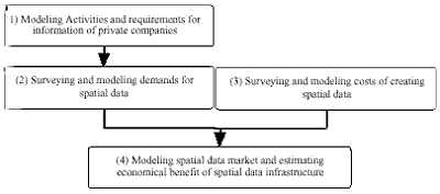
Fig.1 Structure of whole method
4. Modeling Activities and Requirements for Information of Private Companies
As a first step of estimating demands for spatial data, in this research, models are developed, describing standard business activities of various kinds of private companies together with their requirements for information.
To develop such models, the most straight-forward way is to cover all business activities by visiting each office and watching business activities whole day, though it is not feasible at all. So, in this research, the author introduces "Activity Domain Analysis" (ADA) help develop a model of activities of organizations with requirements for information of each activity using existing documents as references.
After developing approximate model of activities of companies, the model is to be checked through interviews with businesspersons who understands actual structure of the business.
4.1. Activity Domain Analysis (ADA)
ADA is a method to extract and classify activities with its information usages according to the purposes of each activity. ACTIVITY in ADA is defined as a group of sequential activities designed to achieve some goal. An assumption underlying this method is that purposes of each activity will not change drastically, even if styles of activities change with technical improvement like informational revolution. Thus ADA can be considered as a method of describing and modeling activities, which can easily take various changes especially in information technologies.
In ADA hierarchical descriptions of activities are made; from activities with general purposes controlling whole activities of people or organizations to subpurposes in order to achieve general purposes. So, ADA can capable to describe largescale and complicated activities.
On the other hand, when arranging information items required by activities, it is necessary to describe and assemble relations between information items after extracting them. In ADA, required information is described as Application Schemas which can represents usages of information and conceptual models in each activity systematically. .
The followings are the detailed procedures of an ADA.
Fig.2 Structure and example of ADA
4.2. Confirming ADA Models by Interview
After developing initial model of business processes using ADA, the model is corrected and confirmed by interviewing with persons who are in charge of actual activities described in the model.
The author considered the concept of ADA as difficult to understand for business persons. When making interviews, the model derived from ADA is converted as work flow chart which is wellknown for businesspersons.
5. Modeling Demands for Spatial Data
After developing models of business activities and information requirement, we must create a quantitative model of demands for spatial data.
5.1. Survey on Demands for Spatial Databases
To create demand model, firstly spatial information is to be chosen among all information required in business processes.
After spatial information requirements are extracted, the following attributes of these requirements are surveyed with interviews or questionnaire surveys.
5.2. Constructing Quantitative Demand Model for Spatial Databases
In this research, quantitative demand model for spatial databases is developed based on the results of the survey above described.
At first, let the number of companies be K (1...k...K).
Assume there are N k business processes in company k.
After the survey, the following information will be acquired.
If the proportion of the company in the trade can be defined as X k , total demand function D of the industry for spatial information m can be defined as following :
6. Modeling Costs of Creating Spatial Data
In this research, supply model of spatial information will also be developed. In this section, the author proposes how to develop a model representing total cost of developing spatial data infrastructure as a function of qualities q of the data.
6.1. Survey on Costs of Creating Spatial Databases
To create cost model of spatial data infrastructure, the author proceeds survey on cost of spatial database products provided by private vendors. Values to gather are as followings :
Using values collected by the survey, we can develop a cost function of developing spatial databases for information item mas follows:
In this research, the author extrapolate this cost function to that for national spatial data infrastructure.
7. Constructing Market Model of Spatial Databases
With the above methods, both demand and cost sub model for spatial databases can be developed. In this section, the authors create spatial data market model using these two sub models.
7.1. Assumptions
Before developing a market model, the author takes some assumptions.
The first one is an assumption relating to the cost. If there is a data infrastructure the some information item m with quality q0 by price p 0 , assume the cost of a spatial database with quality q as follows :
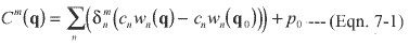
That is, there is no requirements for processes which are used to create basic database when developing databases using the basic one.
The second assumption is relating to activities of suppliers and users. With this assumption, the suppliers of spatial data aim at maximizing profits and every users intend to maximize users' surplus which is calculated by subtracting maximum willingness to pay from the price.
7.2. Action of Spatial Data Suppliers
For one spatial data supplier i, when spatial database product with data quality qi can be sold by Qi sets with price pi , the profit ri of the supplier i can be described as
ri=PiQi-C(qi) (Eqn.7-2)
If each supplier maximizes this profit, the following equation stands.77 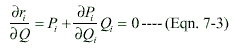
This equation can be transformed as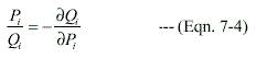
7.3. Action of Spatial Data Users
Users of spatial databases will maximize users' surplus b n which is defined as follows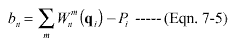
If there is no products with positive bn, the user will give up using spatial database.
As a result, total demands Qi for spatial database i with price Pi and quality qi is described as in the following.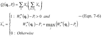
7.4. Total Surplus of Spatial Data Market
By aggregating actions of users and suppliers, production amount Q i and price P i of a spatial database i with given quality q i can be decided. Therefore, the following equation stands.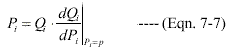
Right side of above equation can be described in the following equation.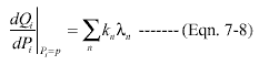
Qi and gni in eqn. 7-8 are defined in eqn 7-6.
By solving equation 7-7, prices Pi and production amounts Qi of a spatial database i can be calculated with an assumption that there is a spatial data infrastructure with quality q0 and price p0.
Total benefit of the spatial data market BTOTAL can be calculated by summing users' surplus BUSER and total profit R.
8. Conclusion and Future Works
In this research, the model has been developed by which spatial database market can be represented, by extrapolating results of Activity Domain Analysis (ADA) for private companies and individual surveys on spatial data suppliers. After that, a method has been developed to estimate proper service levels of the National Spatial Data Infrastructure quantitatively. In future, survey with larger scale should be conducted along the method proposed in this paper.
References
Abstract
With increasing demands for integrated spatial data set by various fields of business, several countries have proceeded their plans for the public sectors to develop such basic spatial databases. It is crucially important to clarify the benefit and appropriate role of the governmental investment. The final purpose of this study is to establish a methodological framework to find proper investment level of national spatial databases. To achieve this, the author proposes a method based on the estimation of economical benefits of spatial data infrastructure and act analysis of spatial data production.
1. Introduction
With rapid increase of information technology, an importance of information-related national infrastructure (Information Infrastructure) is growing rapidly in these days. Information infrastructure consists of both hardware-related infrastructures –– such as glass fiber network or earth stations of satellite networks–– and, software-related infrastructures.
There are two kinds of software-related information infrastructures; one is strategic standardization of data and services, while another is a development of database itself as a national data infrastructure. When developing such information infrastructure, there are many cases which require some assistance of governmental sector like conventional physical infrastructures; highways, sewers, railways, etc... And, it is essential to estimate social benefit of such infrastructures to confirm an efficiency of projects.
In this research, the authors focus on national data infrastructures as a common datasets or databases created by a governmental sector. Among several data infrastructure like patent database, law database, or other national databases, this paper is focusing on national spatial database, which includes map-related information like roads, houses and so on.
The final purpose of this research is to establish a methodological framework determine appropriate service level and proper developing procedures of national spatial databases. In this paper, the authors focus to develop a method to estimate proper service level of national spatial databases.
2. Objectives of This Research
2.1. Social Requirements
In Japan, there is a project named National Spatial Data Infrastructure (NSDI) which is initiated mainly by the National Land Agency.
Typical purposes of developing common database of spatial information are as followings.
- To avoid redundant investment in different databases with same data.
- To induce competition by decreasing entrance cost of the market
- To accelerate reusing datasets by developing one standard of spatial data –– price of datasets using multiple data sources will decrease ––
However, some problems with NSDI project are not solved yet precisely. For example; what kinds of data should be included? How to prioritize datasets to be included? How accurate those data should be? How much money can be spent for the project? Who should be responsible for the development of whole detaset?...etc...
These problems are caused by the fact that techniques or researches of clarifying amounts and objects of social benefits has not yet been systematically.
2.2. Objectives of this research
In this paper, the purpose is to develop a method to clarify (1) how much investment should be done, and (2) what kind of data should be included, for national spatial data infrastructures.
3. Abstract of the Method
With proposed method, economical benefits of spatial data infrastructure is estimated by developing a model of spatial data market. With the market model, we can formulate spatial data suppliers' profit and consumers' benefit when some data infrastructure has been developed. As a result, we can estimate economical benefits due to development of spatial data infrastructure.
There are two essential sub models in the market model. One is a demand sub model and another is a cost sub model. In this research, the author also mentions about how to create these two sub models.
3.1. Outline of Demand Model Development
At first, we develop a model which represents demands for spatial data. A method for the model development aggregates for information (includes information without any spatial element) through all activities of the whole business. This process consists of the steps as shown below.
- Construct a model representing information usages of business procedures
- Pick up demands for spatial information among all requirements for information derived from step (1)
- Survey detailed requirements for spatial data : quality and required data items
- Survey maximum willingness to pay (WTP) for a spatial database
- Survey elasticity of WTP with quality of the data
Cost structure depends who or which institutions develop database. In this research, however, the authors ignore the difference in development cost of database among different institutions, as long as the database has the same quality. Thus, to create cost model of data infrastructure, the author extrapolates the cost model representing cost structures of existing private spatial data companies. Costs of each company will be collected by interviewing to each company or by survey using some questionnaire sheets.
3.3. Overall Structure of the Method
Overall structure of the method proposed in this paper consists of 4 steps (Fig.1)
- Modeling Activities and requirements for information of private companies
- Surveying and modeling demands for spatial data
- Surveying and modeling costs of creating spatial data
- Modeling spatial data market and estimating economical benefit of spatial data infrastructure
Fig.1 Structure of whole method
4. Modeling Activities and Requirements for Information of Private Companies
As a first step of estimating demands for spatial data, in this research, models are developed, describing standard business activities of various kinds of private companies together with their requirements for information.
To develop such models, the most straight-forward way is to cover all business activities by visiting each office and watching business activities whole day, though it is not feasible at all. So, in this research, the author introduces "Activity Domain Analysis" (ADA) help develop a model of activities of organizations with requirements for information of each activity using existing documents as references.
After developing approximate model of activities of companies, the model is to be checked through interviews with businesspersons who understands actual structure of the business.
4.1. Activity Domain Analysis (ADA)
ADA is a method to extract and classify activities with its information usages according to the purposes of each activity. ACTIVITY in ADA is defined as a group of sequential activities designed to achieve some goal. An assumption underlying this method is that purposes of each activity will not change drastically, even if styles of activities change with technical improvement like informational revolution. Thus ADA can be considered as a method of describing and modeling activities, which can easily take various changes especially in information technologies.
In ADA hierarchical descriptions of activities are made; from activities with general purposes controlling whole activities of people or organizations to subpurposes in order to achieve general purposes. So, ADA can capable to describe largescale and complicated activities.
On the other hand, when arranging information items required by activities, it is necessary to describe and assemble relations between information items after extracting them. In ADA, required information is described as Application Schemas which can represents usages of information and conceptual models in each activity systematically. .
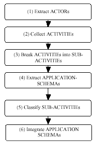
The followings are the detailed procedures of an ADA.
- Extract subjects of each business process (These subjects are called as ACTORs)
- Extract purposes of daily business activities of each ACTOR. (The activities grouped under the same purpose are called as ACTIVITIEs)
- Disaggregate ACTIVITIEs into more detailed and smaller items (called as SUB-ACTIVITIEs. Each SUB-ACTIVITIEs are for the "sub-purpose" of the "parent" purpose.)
- Extract requirements for information in each SUB-ACTIVITY. (These requirements are called as APPLICATION-SCHEMEs)
- Classify SUB-ACTIVITIEs which have similar APPLICATION-SCHEMEs
- Integrate APPLICATION SCHEMEs of typified SUB-ACTIVITIEs
 |
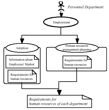 |
Fig.2 Structure and example of ADA
4.2. Confirming ADA Models by Interview
After developing initial model of business processes using ADA, the model is corrected and confirmed by interviewing with persons who are in charge of actual activities described in the model.
The author considered the concept of ADA as difficult to understand for business persons. When making interviews, the model derived from ADA is converted as work flow chart which is wellknown for businesspersons.
5. Modeling Demands for Spatial Data
After developing models of business activities and information requirement, we must create a quantitative model of demands for spatial data.
5.1. Survey on Demands for Spatial Databases
To create demand model, firstly spatial information is to be chosen among all information required in business processes.
After spatial information requirements are extracted, the following attributes of these requirements are surveyed with interviews or questionnaire surveys.
- Category of required information (c.f. roads, sewers, etc...)
- Required quality of information
- Maximum investment for such information
- Elasticity of maximum investment with changes in qualities
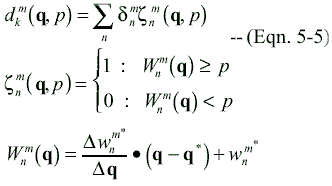
5.2. Constructing Quantitative Demand Model for Spatial Databases
In this research, quantitative demand model for spatial databases is developed based on the results of the survey above described.
At first, let the number of companies be K (1...k...K).
Assume there are N k business processes in company k.
After the survey, the following information will be acquired.
- Category of required information
----(Eqn. 5-1)
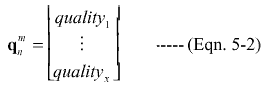
Let there be M kinds of spatial information (1...m...M)
- Required quality of information
- Maximum investment for such information
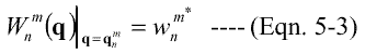
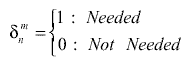
Wnm: Function represents maximum willingness to pay of activity n for information item m.
- Elasticity of maximum investment against changes in qualities
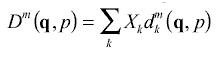
If the proportion of the company in the trade can be defined as X k , total demand function D of the industry for spatial information m can be defined as following :
6. Modeling Costs of Creating Spatial Data
In this research, supply model of spatial information will also be developed. In this section, the author proposes how to develop a model representing total cost of developing spatial data infrastructure as a function of qualities q of the data.
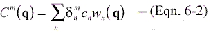
6.1. Survey on Costs of Creating Spatial Databases
To create cost model of spatial data infrastructure, the author proceeds survey on cost of spatial database products provided by private vendors. Values to gather are as followings :
- Detailed processes of creating each element of spatial database
From this survey, the following values can be defined.
Let the number of processes of creating databases of spatial information m as Nm
- Required amount of each process as a function of data quality q
Wn(q)
- Cost of a unit of such process
Cn
Using values collected by the survey, we can develop a cost function of developing spatial databases for information item mas follows:
In this research, the author extrapolate this cost function to that for national spatial data infrastructure.
7. Constructing Market Model of Spatial Databases
With the above methods, both demand and cost sub model for spatial databases can be developed. In this section, the authors create spatial data market model using these two sub models.
7.1. Assumptions
Before developing a market model, the author takes some assumptions.
The first one is an assumption relating to the cost. If there is a data infrastructure the some information item m with quality q0 by price p 0 , assume the cost of a spatial database with quality q as follows :
That is, there is no requirements for processes which are used to create basic database when developing databases using the basic one.
The second assumption is relating to activities of suppliers and users. With this assumption, the suppliers of spatial data aim at maximizing profits and every users intend to maximize users' surplus which is calculated by subtracting maximum willingness to pay from the price.
7.2. Action of Spatial Data Suppliers
For one spatial data supplier i, when spatial database product with data quality qi can be sold by Qi sets with price pi , the profit ri of the supplier i can be described as
ri=PiQi-C(qi) (Eqn.7-2)
If each supplier maximizes this profit, the following equation stands.
This equation can be transformed as
7.3. Action of Spatial Data Users
Users of spatial databases will maximize users' surplus b n which is defined as follows
If there is no products with positive bn, the user will give up using spatial database.
As a result, total demands Qi for spatial database i with price Pi and quality qi is described as in the following.
7.4. Total Surplus of Spatial Data Market
By aggregating actions of users and suppliers, production amount Q i and price P i of a spatial database i with given quality q i can be decided. Therefore, the following equation stands.
Right side of above equation can be described in the following equation.
Qi and gni in eqn. 7-8 are defined in eqn 7-6.
By solving equation 7-7, prices Pi and production amounts Qi of a spatial database i can be calculated with an assumption that there is a spatial data infrastructure with quality q0 and price p0.
Total benefit of the spatial data market BTOTAL can be calculated by summing users' surplus BUSER and total profit R.
8. Conclusion and Future Works
In this research, the model has been developed by which spatial database market can be represented, by extrapolating results of Activity Domain Analysis (ADA) for private companies and individual surveys on spatial data suppliers. After that, a method has been developed to estimate proper service levels of the National Spatial Data Infrastructure quantitatively. In future, survey with larger scale should be conducted along the method proposed in this paper.
References
- T. Sakakibara, R. Shibasaki, 1999. A Study On The Design Of Spatial Data Infrastructure(SDI) Using Activity-Based Domain Analysis (ADA), 20th Asian Conference of Remote Sensing
- Jones P., 1988. Practical Guide to Structured System Design Second Edition. Prenetice-Hall Inc.
- Yourdon E., 1994. Object-Oriented System Design An Integrated Approach. Prentice-Hall Inc.
- Ray B., Ron C., 1996. Use Case Maps for Object-Oriented Systems. Prenetice- Hall Inc.