| GISdevelopment.net ---> AARS ---> ACRS 1999 ---> GIS |
The Exemplary Effect of
GeoStar in the Spatial Data Infrastructure Construction in China
Jianya Gong, Deren
LI
Wauhan Technical University of Surveying and Mapping .Wuhan, China
jgong@regis.wtusm.edu.cn
Keywords: spatial data infrastructure; digital
geospatial data framework ; digital orthophotos; DEM; integrated spatial
database. Wauhan Technical University of Surveying and Mapping .Wuhan, China
jgong@regis.wtusm.edu.cn
Abstract
This paper presents some ideas about the design and implementation of the China National Spatial Data Infrastructure, base on a pilot project . The production technologies and processes to collect spatial data are described, and An integrated spatial database management system based on Geostar is also introduced.
1. Introduction
As the rapid development of computer and information technologies, geographic information system (GIS) has come into practice. At present, geographic information system construction and its application have sprung up. In the application of the geographic information system, an urgent problem to be solved is data sharing. After years of developing, we have gained certain geospatial data and thematic data and thematic data. The National Bureau of Surveying and Mapping has possessed of spatial data with scales of 1:2,500,000, and 1;10,000,000 covering the whole China and has produced spatial data with scales of 1;100,000 and 1:500,000 in some regions. Many big cities have accomplished the work of digitalization of large -scale map. However, the major problem to be settled of the current GIS development is how to manage and maintain the spatial data, which will lead to the spatial data sharing.
Spatial Data Infrastructure (SDI) is an important concept proposed for the sake of spatial data sharing and distribution. In the recent years, organizations related to the UN, national, provincial and local governments of each country have attached much importance to the SDI at all levels. Global Spatial Data Infrastructure ( GSDI), Regional Spatial Data Infrastructure (RSDI), National Spatial Data Infrastructure (NSDI), Provincial Spatial Data Infrastructure (PSDI) and Urban Spatial data Infrastructure (USDI) have come forth, which has promoted SDI and NII constructions to an important strategic status of the future informations society development. The main propose is to establish relevant organizations and criteria , expedite the production of spatial data, reduce repetitive collection of spatial data, maintain the reality, validity and authority of spatial data and accelerate the development of GIS .
SDI includes four aspects : first, the system of organizations and data distribution, second, the spatial data criteria, third, spatial data clearinghouse which includes large-scale severs, high speed communication networks, spatial database managing system, spatial data distribution and so on, fourth, digital geospatial data framework. In SDI, one apparent feature of digital geospatial data framework is that it includes not only traditional vector data, but also digital orthophotos data and Digital Elevation Model (DEM).
GeoStar is a GIS software developed by Geo information engineering Company at Wuhan Technical university of Surveying and Mapping. The Software covers all the functions of current GIS software. So as to adapt to the special need of the National Spatial Data infrastructure, it also includes many special function.
Aiming at the situation the most current commercial GIS software is difficult to meet the need of SDI construction, when Wuhan Technical University of Surveying and Mapping was developing GeoStar , the National Bureau of Surveying and Mapping had proved that GeoStar would carry out the pilot project study of PSDI. In the following, the implementary technologies of the pilot project of PSDI construction will be introduced in detail.
2. The contents of the spatial data set
In order to establish the spatial data infrastructure in China as soon as possible, factors such as the speed and efficiency required to collect spatial data and the completion, importance, processing and expansion of the information have to be considered. Therefore, the spatial data set should be a Digital Geospatial Data Framework (DGDF), which includes the following contents.
First, the most important type of geospatial data the digital orthophotomap. Digital photogrammetry or remote sensing will be adopted in the production of the digital orthophotomap at the scales 1:10,000 and 1:50,000. the production technologies to produce the digital orthophotos have already come into operation rapidly and efficiently . in addition, the digital orthophotos have already come into operation rapidly and efficiently. In addition, the digital orthophotos includes such abundant information the vector data can be captured from the orthophotos according to user's needs.
The Digital Elevation Model (DEM) is not only used for generation of the digital orthophotos, but also serves many application in GIS such as road design, flood prevention and agricultural planning. The form of Dem can be grid, TIN or hybrid.
Several layers of vector data are necessary. These vector data should include administrative boundaries, transportation and drainage. These three layers of vector have many GIS application, and they are included because they are both important and easy to collect.
The cadaster, extent of residential area, vegetation, pipe lines and communication lines are also normally useful in GIS. But collecting these vector data would take a long time, and therefore these data are not includes in the DGDF of China.
A DGDF must also include a geodetic control point database ad a place name database. These tow kinds of data are stored in a table and their positions displayed on the digital map.
In total, the Digital Geospatial Data Framework of China should include digital orthophotos, digital elevation models, administration boundaries, transportation and drainage as well as the database of geodetic control points and database of place names. Other features can added properly when users need them. If only the geographic information above is produced, the working efficiency can be 5 to 10 times faster than by vectorizing full- feature maps. It can meet the demand of rapid renewal of a national GIS caused by the rapid development of the economy in China.
3. The production technologies and processes of DGDF
The DGDF mentioned above includes three kinds of data, viz, involving digital orthophotos, digital elevation models and vector data. In this section, the technologies and process to produce the various datasets will be considered in more detail according to different situations regarding equipment and quality standards of production.
The production of vector data involves mature technological procedures. However different methods exist according to different equipment held. These methods include digital stereo photogrammetry, analytical photogrammetry, vectorization of scanned maps and digitizing vector data on digitizer. In addition, if the digital orthophotos already exists, acquiring vector data from digital orthophotos is a good method.
According to different data resources and equipment, the digital orthophotos can be obtained by several methods, a main method is digital stereo photogrammetry ( Zhang and Zhang, 1997), whereby the digital orthophote and the DEM are obtained at the same time. If the DEM exists as a product of either analytical photogrammetry or by interpolating DEM from vectorizing contour maps, digital differential rectifying can be used to produce the digital orthophotos directly \. If the analogure orthophotos maps were made by using optical instruments line a rectifying orthophotos instrument , the digital orthophotos maps can be acquired after scanning the analogure orthophotos maps. With the development of remote sensing technology, the high-resolution image can be used as the data resource of digital orthophote. The above methods can usually meet the required standards in accuracy and reliability.
There also are several different technologies to produce DEMs including fully automatic digital photogrammetry, interactive digital photogrammetry, analytical photogrammetry and interpolating DEM from vector countours lines. But each method has a different accuracy and efficiency . tests have indicates the analytical photogrammetry and interpolating DEM by using scanned contour lines have high accuracy; the accuracy is better by using interactive digital photogrammetry than by fully automatic digital photogrammetry, because the interactive digital photogrammetry needs to capture the topographical characteristic lines and more artificial editing .
4. Establishment of geospatial database
The spatial data including digital orthophote, digital elevation models and several layers of vector data are collected by the above approaches. In order to manage and distribute the spatial data, it is necessary that an integrated spatial database with raster data and vector data has to be built. The spatial data has to be built. The spatial data can be stored in file, or in a commercial database management system. No matter which approach is used, the spatial database should be designed as logically seamless. The software for managing the spatial database should have the following functions:
- The spatial data can be searched and queried in the whole spatial database
- The vector graph should overlay on the image transparency. The new image cane be directly used to update the old vector graph through capturing and editing.
- A multi-resolution image database should be built in pyramid form so that the system can read the image data from different levels according to different displays scales.
- The function should include displaying, querying and panning in an integrated interface with DEM and image.
- All spatial data can be transferred to other GIS or remote sensing processing system.
- Visualization or mapping should be made according to the sheet number or range user-given.
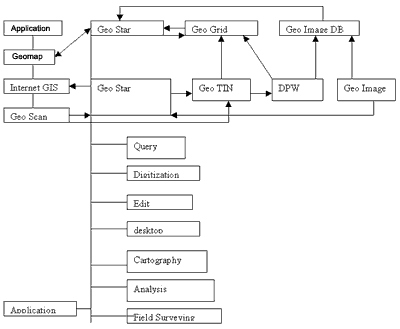
Figure 1. The Structure of Geostar
To establish the integrated spatial database, there are still many problems to be solved. Therefore, the National Bureau of surveying and Mapping in China has approved a pilot project for PSDI which is being carried out jointly by the Land Department of Guangdong Province and Wuhan Technical University of Surveying and Mapping.
In order to research on an integrated spatial database for the whole of China, a pilot integrated spatial database including multiple scale of digital orthophotos, EM, and several layers of vector data covering Guangdong Province has been created using GeoStar. The system involves TM remote sensing image, DEM and vector data with the scale of 1:250,000 cover the whole province, SPOT-Tm fusion image data with the scale of 1:50,000 covering the Zhujiang River delta, and aerial digital orthophotos and DEM vector data with the scale of 1;10,000 cover the Zhujiang River delta. All of them have formed a multi-scaled and multi-sources spatial database. Since a multi-scaled database is built, the system can access data in different levels according to the scale users have decided. Figure 2 is the general image map of a province. When we are interested in a city, we may zoom out gradually and get images with scales of 1:250,000 ( Figure 3), 1:50,000 ( Figure 4), and 1:10,000 ( Figure 5). This method is also fit for vector database DEM database or combination of the three database.
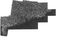 Figure 2 The general image map of Guangdong Province |
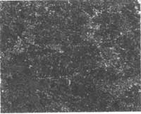 Figure 3 The image map with the scale of 1:250,000 |
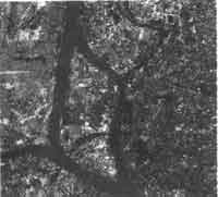 Figure 4 The image map with the scale of 1:50,000 |
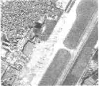 Figure 5 The image map with the scale of 1:10,000 |
5. Conclusion
With the development of computer technologies, digital photogrammetry, remote sensing and GIS, it is possible to establish a national spatial Data Infrastructure. The Digital Geospatial Data Framework in CNSDI consists of the digital orthophoto, digital elevation model and several layers of vector data including administrative boundaries, transportation and drainage as well as the database of geodetic control points and of place names. The productions efficiency of these framework data can be 5 to 10 times faster than by vectorizing full feature maps. It can meet the demand of rapid renewal of GIS caused by the rapid renewal of GIS caused by the rapid development of the economy in China.
This paper discusses series of technologies used for collecting geospatial data. Most of them are well established and can meet requirement in accuracy. However, as the test illustrates, it is still difficult to get high accurate DEM by using digital photogrammetry Because the China NSDI would be a large project for the whole of China, more research is required focused on integrated spatial database to include digital orthophoto DEM and vector data. The pilot integrated spatial database covers only one province, and is therefore just a beginning for research on the integrated spatial database. The next work is at establishing distribution systems of spatial data.
Reference:
- Gong , Jianya, 1997a, Design and Key Technologies on Geographic information System Software GeoStar NT Version, Journal of Wuhan Technical University of Surveying and Mapping, No.3.
- Gong, Jianya, 1997b, Construction of Digital Geospatial Data Framework in China Surveying and Mapping in China, no.4.
- Li, Deren, 1997, Some Thinking on Geo-Information theory, Journal of Wuhan Technical university of Surveying and Mapping , No. 2.
- Spatial Data Commission, USA, 1994, Construction of American national Digital GeoSpatial Data Framework.
- Zhang, Zhuxing and Zhang, Jianqing, 1997, Digital Photogrammetry, Press Houses on Surveying and Mapping, Beijing.