| GISdevelopment.net ---> AARS ---> ACRS 1999 ---> Geology |
A Practical Approach To
Creating A Landslide Database Using Taiwan SPOT Mosaci
Jin-King LIU and Tsun-Cheng
WOING
Research Scientist, Energy and Resources Laboratories (ERL)
Industrial Technology Research Institute (ITRI)
195-6, Sec.4 Chung-Hasing Road, Shin 310, China Taipei
Tel: (886) -3-561-3648 Fax: (886)-3-582-0017
E-mail : f660124@erl.itri.org.tw
Abstract Research Scientist, Energy and Resources Laboratories (ERL)
Industrial Technology Research Institute (ITRI)
195-6, Sec.4 Chung-Hasing Road, Shin 310, China Taipei
Tel: (886) -3-561-3648 Fax: (886)-3-582-0017
E-mail : f660124@erl.itri.org.tw
The purpose of this study is to pursue a practical approach for generating a useful landslide database on basis of Taiwan SPOT mosaic, which is a resample image with a resolution of 6.25 m processed by the center for space Research and Rte ote sensing, National Central University , Taiwan. There are tow issues for creating a useful landslide database of a national area, i.e the consistency of the data-set and the completeness of the coverage. Taiwan SPOT mosaic gives an opportunity of make a landslide map with a complete coverage of Taiwan. Thus, we try to work on a practical approach to make use of this image.
A semi -automated approach is proposed and demonstrated by working in a 515 Mb image on Nantou County in central Taiwan, implemented on a selected GIS environment. A will-trained GIS specialist with limited knowledge of geology and a well-trained geologist with limited knowledge of GIS are assigned to work on the image. after a comparison of both results and a result generated by aerial photo-interpretation, it is recognized that the training in geology seams more critical than the acquaintance of computer sills . it is also proved that the semi-automated approach is an efficient and effective approach, which can be further applied for the generation of a landslide database of the whole Taiwan.
1. Introduction
It has been a long-existing problem in Taiwan to install a national database of landslide for mitigation of natural hazard. Due to the vast expanse of the mountainous terrain of Taiwan, population is concentrated in the 30% of the flat land in the western part. Though several government agencies are designated to take care of these areas, little progress has been done thanks to the low accessibility of the terrains. In the total area size of 36000 Km2 of Taiwan, only a small portion has been surveyed ( Table 1).
It is recognized Agriculture Council that a program on landslide mapping is necessary had a pilot study was launched in 1997 ( Liu, 1998) by using aerial poto-interpretation approach, which may take 3 or 4 more years to obtain a completer coverage. Two major issues remains to be resolved, e.g (a) the consistency of the data-set; and (b) the completeness of the coverage.
A completer coverage map of Taiwan created on basis of unified criteria using an unified approach is the matter of concern. The difficulties are sue to the time span, differences in scale of sources data, variety of personnel, and institutions or agencies concerned. Even aerial photographs are used, the coverage of the photographs is not consistent. In our experience, it requires 5 to 8 years to make a complete coverage of aerial photographs of the whole Taiwan Area to overcome cloud cover.
Taiwan SPOT mosaic gives an opportunity to make a landslide map with a completer coverage of Taiwan SPOT mosaic is a re-sampled image with a resolution of 6025 m processed by the Center fro Space Research and Remote Sensing, National Central University, Taiwan. The SPOT mosaic employed in this study is complied form images taken in four days, that is 1996/01/01 , 1996/01/02, 1996/10/28, and 1995/11/25.
In this study ,a semi -automated approach is proposed and demonstrated by wor5king on a 515 Mb color-composite image of Nantou County in central Taiwan. This is implemented on a selected GIS environment. A well-trained GIS specialist and a well-trained geologist are assigned to work on the same image . this is to prove that a practical database can be gained from a practical approach by using SPOT mosaic.
| Source agency | Time period | Data set | Scale | Coverage (Hectare) | Delineation of Geological Hazard | Categorization of Landuse Capability |
| Construction Agency of Taiwan Provincial Government | 1980-1997 | Enviromental geological database of metropolitan areas | 1/5000 | 345,000 | Landslides, faults, dumping sites and abandoned mines are indicated on the environmental geological map. | Four categories of hazard are indicated on the landslide susceptibility map to show the relative cost of the land development |
| Central Geological Survey | 1979-1984 | Engineering geological survey of the residential lands in the sloping areas. | 1/25000 | 141,122 | Geological map shows the location of faults. Slopw map shows the steepness of the slope. | A development proposal plan is given to advise the areas of suitability of land development. |
| Agriculture Council | 1991-1998 | Identification of streams prone to debris flows. | 1/100000 partial 1/5000 - 1/10000 | Whole Taiwan | A distribution map of the streams prone to debris flow. | Nil |
| National Science Council, Ministry of Interiors, and Taipei City Government | 1975-1987 | Landuse Capability and natural hazard mapping | 1/25000 1/15000 1/10000 1/5000 1/1200 | 91,941 | Potential hazard is indicated on the landform unit (defined on basis of geological and geomorphological factors). | Landuse intensity and risks are proposed on the maps. No information of landslide location and extent. |
| Construction Administration Agency of Ministry of Interiors | 1995-1997 | Environmental Sensitive areas and Land suitability maps. | Regional Plans of North, Mid, South, & East Tw. | Compiled data of Whole Taiwan areas | Data compilation | Nil |
2. Conventional Aerial Photo -interpretation
It has been proved that conventional stereoscopic study of aerial photographs is very effective for delineation of landslide feature in Taiwan Area ( ERL, 1992-1996; ERL, 1998). The major advantage of photo-interpretation as compared to satellite image processing is that individual landslide can be well defined such that a landslide can be recorded with an identification number, wit its own area size, and its own extent and environmental characteristics.
However, to obtain a completer coverage of aerial photographs of an area such as Nantou County becomes a problem . as shown in Figure 1, the index map of aerial photographs of Nantou County, 1680 photographs were taken in 1993, 1996, 1997 and 1998 with more than 20 Flight paths. The quality of the photographs is not consistent. And the interpreter taking care of various sets of photographs may adopt slightly different criteria. Thus, this may result in an inconsistency. Furthermore, the result of the interpretation has to be transfer to a base map. And, subsequently, draftsman has to clean the dusty maps before that can be put on a digitizer table for digital entry to a database. Errors can be introduced in any one of the steps.
3. Automatic Image Classification
It is common practice for remote sensing specialists to handle digital images with automatic image classification. The advantage is to adopt a discriminate algorithm for the automation, which is repetitive and objective. Further, as compared to photo-interpretation, this approach is less time consuming and introduce less errors in the process of creating a database thanks to the procedures are not complicated by human interruption.
However, vegetated landslides may not be able to be identified by any classification algorithm because the spectral pattern in these areas depicted no contrast to the environs. The highly-fractured and highly-fractured and highly -weathered physical environment of Taiwan area make it very quick to recover vegetation cover after the landslide take place. Small landslides with a length less than 50 meters may not be identified due to the resolution of the satellite image. Especially the complexity of the environment of the mountainous terrain make the classification a painting-like result rather than a map -like result, as shown in figure 2, an ISO class map of Don-Pu Area of Nantou County. This is not a so-called a useful database for planning mitigation measures.
4. The semi-automated approach
Figure 3 is a biow-up of the SPOT mosaic in the upper -stream area of chen -yo-Lan stream in Nantou country. The landslides are in white tone .They are conspicuous due to the tonal contract with the environs and unique shape. Further They are located either near the stream or road cut . the interpretation key as thus is similar to that used for interpreting color aerial photographs, as shown in Figure 4, Therefore, if we can obtain the size and extent of landslides and creator the records in digital form directly, we can obtain the size and extent of landslide and create the records in digital form directly, we can gain the benefit of the advantages of both photo-interpretation and digital image processing. A straightforward approach is to adopt the 6.25m SPOT mosaic in a GIS environment. By the assistance of the GIS, an on-screen interpretation process and an on -screen digitization process are merged to become a process. This is named in this paper " the semi-automated approach".
A sub-set of the Taiwan SPOT mosaic covers Nantou county is employed in this study. The image has a data volume of 515 Mb ( number of samples = 12080; number of lines = 14560). The selected GIS environment includes an Autocad map R2 and a map info 4.5. Two persons are assigned to work on the same data set. One is a well-trained GIS specialist, who is acquainted with GIS software, capable of writing GIS macros, and with nearly 10 years of experiences in map digitization. The other is a well trained geologist, who is acquainted with field geological mapping and landslide survey, capable of managing survey project, and with nearly 10 years of aerial photo-interpretation. Both of then are working on an identical PC-586 environment with 64 MB RAM, 6.4 GB HDD , CPU 266 MHz, and windows 95. No significant differences are observed by the results of working on different GIS system. However, a critical difference does happen between the two of different expertise. This is to be discussed In the following.
5. Discussion and Conclusion
By conventional stereoscopic photo-interpretation, 1680 photographs are interpreted by 4 well-trained personnel using tow weeks. In total, 40 work-days are used to do the interpretation, 4076 landslides with 234,059,976 m2 are identified. After 60 more work-days of data transfer, cleaning, and digitization, a landslide database of Nantou County is created ( Figure 5).
The well -trained geologist spends only tow days in front of the computer, a landslide database of the Nantou County is created ( Figure 6). On the other hand, the well-trained GIS specialist work s out a first result with three days. The result is a 269 pseudo-landslides, which is proved with 70% of errors. Source of the mistakes are due to only considering the tonal feature, over looking to the features of a landslide, including the location, shape, and trend of the long-axis. A second result was worked out after two more days. 708 places of landslides are recognized ( Figure 7). There are only 5% of errors. Some large-scaled landslides are overlooked. Nevertheless, a third time of work generates an interesting result. A total of 1650 landslides are delineated ( Figure 8). Errors are more than 70%. Errors are originated from the hesitating and uncertainty of the training background of the GIS specialist. The northeastern part of the study area is cloudy are. Tens of shadows and artificial features are mistaken as landslides. Omission of the large-scaled landslides in the southeastern part is still there. This gives an important indication of the problem that results of good quality can only be obtained by professional people in landslide geology.
The comparison of results by geologist and GIS specialist and the API result concludes that the training in geology seams more critical than the acquaintance of computer skills. It is also proved that the Simi-automated approach is an efficient and effective approach , which can be further applied for the generation of a landslide database of the whole Taiwan by using the Taiwan SPOT mosaic.
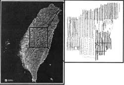
Figure 1 Index map of the coverage of aerial photographs of Nantou County, Taiwan
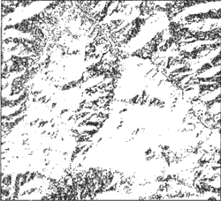
Figure 2 SPOT ISO clas of Don -Pu Area of Nantou County. The dark areas are classified as landslide area.
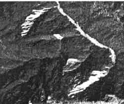
Figure 3 An enlargement of SPOT mosaic of the upper-stream area of Chen-Yo-lan Stream in Nantou County. Landslides in white tone are conspicuous.
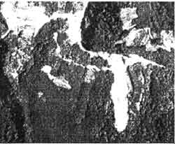
Figure 4 Color aerial photographs in the catchment area of Shi-Men Reservoir. A landslide in white tone is readily shown.
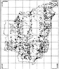
Figure 5. Landslides interpreted from 1260 aerial photographs. 4076 landslides with Max /Min /Avg Size of 5150m, 10m, and 321m.
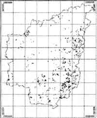
Figure 6. landslides interpreted by well trained geologist from SPOT mosaic, 755 landslides with Max/Min/Avg size of 2000m, 32m, and 250m.
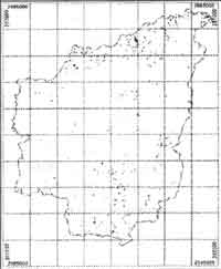
Figure 7. Landslides interpreted by well-trained GIS specialist from SPOT mosaic 708 landslides are identified. Large-scaled landslides are overlooked.
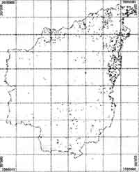
Figure 8. Landslides interpreted by well-trained GIS specialist from SPOT mosaic 1650 pseudeo-landslides are identified.
Reference:
- Liu Jin-King (1998) Identification and predication of Dip Slopes by API GIS Approach. Arcs 19, Philippines.
- ERL (1992) Remote sensing application on mountainous geological environment : (1) Hsieh -Shan Area. ERL report 06-3-82-0017. 113 Pages.
- ERL (1993) Remote sensing application on mountainous geological environment : (2) Nan-Da-Shan Area. ERL report 06-3-83-0023. 122 pages.
- ERL (1994) Remote sensing application on mountains geological environment: (3) Neng- Gau- Shan Area. ERL report 06-3-84-0020. 142 pages.
- ERL (1995) Remote sensing application on mountainous geological environment: (4) Bei- Nan- Shan Area. ERL report 06-3-85-0055. 98 pages.
- ERL (1996) Remote sensing application on slopeland geological hazard. ERL report 06-3-85-0262. 66 pages.
- ERL (1998) Aerial Survey of Landuse and Landslides in the catchment area of Shi-Men Reservoir. ERL repot 06-3-87-0020. 100 pages.