| GISdevelopment.net ---> AARS ---> ACRS 1999 ---> Forest Resources |
A Case Study for Evaluation
of the Feasibility of Mapping Forest and Non-forest using ILU Image Over
Zengcheng Country in China
Li Zengyuan1
Betlem Rosich2 Chen Erxue3
1, 3Chinese Academy of Forest, Beijing, China, 100091
2ESRIN of European Space Agency
Keywords: Forest mapping, ILU image ERS SAR
Tandem, Interferometric coherence 1, 3Chinese Academy of Forest, Beijing, China, 100091
2ESRIN of European Space Agency
Abstract
In order to evaluate the feasibility of ERS SAR Tandem data for mapping forest/non-forest cover, a case study was carried out over Zhengcheng County in the South China. Digital Land Use Map of this county was used as ground truth to collect signature of different land use types and to evaluate forest and non-forest classification accuracy. A hierarchical classification tree was established for land use types classification by careful analysis of histograms of several land use types. The classification result was analyzed by comparison with digital ground truth data pixel by pixel. It was shown that there was a considerably good agreement between the ground truth forest map and the obtained forest and non-forest map. An accuracy of 75% has been achieved.
Introduction
Due to small incidence angle (23°) and low penetration depth in forest covers at C-band, ERS SAR data is some limited for forest application[1]. However, applications can be broadened significantly when interferometric coherence derived from repeat-pass ERS INSAR data are considered[2], in addition to the usual backscatter information. The interferometric coherence, which is an indicator of the temporal stability of the target in terms of geometric and dielectric properties, proved to be a good discrimination in cultivated areas and forested landscapes[3, 4]. Furthermore, ERS SAR tandem data is proved to be extremely useful for discriminating forest from non-forest in many areas of the world[5]. It also provides unique information over regions permanently covered by clouds, such as many areas in China. So a case study for the evaluation of the feasibility of mapping forest/non-forest using ERS SAR tandem data has been carried out and some promising results have been achieved. The primary validation results over the experiment size, Zengcheng County in the South China, will be presented in detail.
Test Site and ERS Tandem Data
Test Site Selection
In order to evaluate the feasibility of forest and no-forest mapping using ESR Tandem data, an ideal test site should be carefully selected. Selection of test site was based on the following criteria:
- availability of ground truth data in digital format;
- existence of other satellite data (Landsat) as support for the evaluation of the results;
- possibility to carry out field work, if necessary, for checking ERS results in particular points;
- availability, in the ESA archives, of an ERS-SAR tandem pair acquired during the dry season over this region (i.e. from November to April).
Table 1 ERS-1 and ERS-2 Tandem INSAR data used
|
| |||
| Items | Date | Track | Frame |
|
| |||
| ERS-1 | 1996-03-02 | 24211 | 3141 |
| ERS-2 | 1996-03-03 | 4538 | 3141 |
|
| |||
ERS SAR Data Processing
The selected ERS SAR tandem pair was processed with the IQL (Interferometric Quick Look) Processor at ESRIN. This processor is capable to produce multiple outputs with selectable characteristics. In this case, the following images were obtained:
- the intensity image corresponding to the ERS-1 SAR acquisition;
- the intensity image corresponding to the ERS-2 SAR acquisition; and
- the interferometric coherence.
Clasification Methodlolgy
Using the geo-referenced ILU image, a classification methodology based in the behavior of intensity, coherence and change of intensity for different surfaces has been defined. The key idea for establishing a classification procedure is that surfaces presenting similar radar intensity values may present very different values of coherence. Therefore, the appropriate combination of intensity and coherence values will make possible to distinguish between surfaces which are hardly discriminated if only SAR intensity is used.
 |
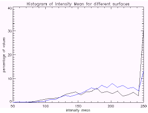 |
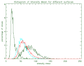
Fig. 1 (a)Histograms of Intensity Mean |
Fig. 1 (b)Histograms of Intensity Mean |
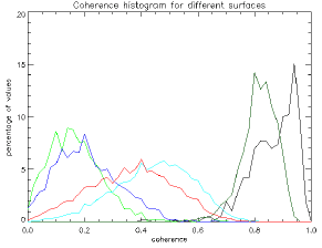
Using ILU image to easily distinguish some areas corresponding to different surface types, several samples of different surfaces (forest, fields–which include farmlands, rice, fruit trees, etc., water, urban and layover) were selected. For these surface samples, the histograms of intensity, coherence and intensity change were extracted. These histograms are showed in figures 1~3.
 |
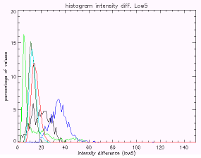 |
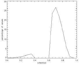
Fig. 2 Histogram of Coherence |
Fig. 3 Histogram of Intensity change |
Some conclusions can be directly derived from the previous histograms:
- SAR intensity allows easy separation between (1) urban and layover areas and (2) fields, forest and water areas. There is a high overlap between intensity values of areas corresponding to forest and fields and some overlap with intensity values of forest and water bodies;
- Coherence clearly discriminates between (1) water and forest and (2) urban and fields. Values of coherence present certain overlap over layover and water areas;
- Intensity change is able to partially solve the ambiguity between some water and forest areas.
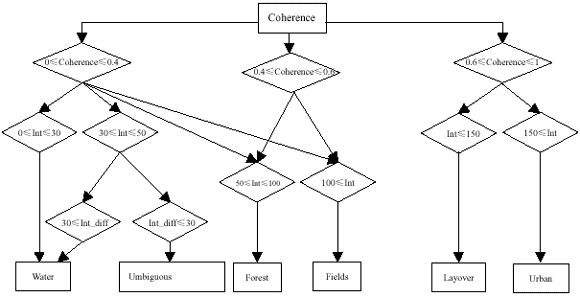
Fig. 4 Hierarchical classification tree
Note: “ int” represents the intensity mean and “int_dif” stands for the intensity change between both acquisitions
Clasification Resulit Evaluation
Available Ground Truth data
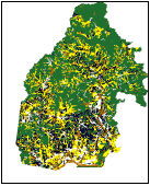
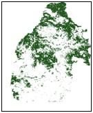
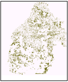
A digital land use map of the Zengcheng county mapped in 1990 was used to validate the results obtained with ERS. This land use map provides detailed information of the type of surface, as it can be observed in fig.5. In order to simplify the evaluation of the results, the map corresponding to the forest class was extracted from this complete land use map and it is shown in fig. 6.
 |
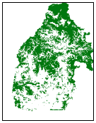 |
Fig. 5 Land Use Map of Zengcheng (forest is in dark green) |
Fig. 6 Forest class extracted from the Land Use Map in fig.5 |
Classification results
Applying the algorithm described in fig. 4, six images showing the pixels classified as each one of the six distinguishable surfaces (forest, fields, water, urban, layover and unambiguous water-or-forest) were obtained. For the purpose of results evaluation, we are only interested in the forest class. The pixels classified as FOREST are showed in fig. 7.
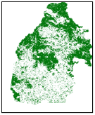
Fig. 7 Forest class extracted from classification using ILU image
Comparing the ground truth forest (fig. 6) and the classified forest (fig.7), the first quantitative values of the accuracy of forest-non forest classification are derived (table 2).
Table 2 Forest classification accuracy
|
| |
| Items | Percentage |
|
| |
| Forest classified as forest | 70 % |
| Forest classified as non-forest | 15 % |
| Non-forest classified as forest | 10% |
| Non-forest classified as Non-forest | 5% |
|
| |
| Total classification accuracy | 75% |
|
| |
Images 8, 9 and 10 show respectively: those pixels corresponding to forest and classified as forest, those pixels classified as non-forest but corresponding forest areas, and finally those pixels classified as forest but corresponding to non-forest areas.
 |
 |
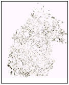 |
Fig. 8 Forest classified as forest |
Fig. 9 Forest classified as non-forest | Fig. 10 Non-Forest classified as forest |
As it can be observed, the major error occur for areas indicated as forest in the ground thruth map and not detected as forest in the classification process. In principle, there may be several reasons for this missclassification:
- a change in the surface (e.g. deforestation) occurred between the field work carried out for generating the land use map and the acquisition of the ERS data here used.;
- a missclassifcation in the ground thruth map;
- a bad tunning of the classification algorithm parameters (see fig.4);
- particular characteristics of the non-detected forest which make it appear in intensity and/or in coherence as non-forest areas
 |
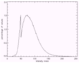 |
Fig. 11 Histogram of coherence for forest areas classified as non-forest |
Fig. 12 Histogram of intensity mean for forest areas classified as non-forest |
The above histograms show that most of the pixels indicated as forest in the land use map which have not been classified as such, present intensity values within the expectable dynamic range but coherence values much higher than what would be expected over forest areas. In other words, this means that these areas have probably been deforested between the generation of the land use map and the ERS acquisitions.
What has been here presented are the preliminary evaluation results, derived from the land use map of Zhengcheng County in 1990. However, in order to carry out a more precise evaluation of the obtained forest-non forest map, Landsat images and specific field work will be exploited and a complete evaluation based on them will be carried out in the future.
Conclusion
Several conclusions can be directly derived from the results presented in the previous section:
- There is a considerably good agreement between the ground truth forest map and the obtained forest/non-forest map (75 % of accuracy).
- The methodology used for the classification is highly based in the coherence behaviour of forest and non-forest surfaces, which is essential for reaching the above accuracy.
- There is certain umbiguity between water and forest areas which is difficult to solve from the information used in this exercise (intensity, coherence and intensity change). The traditional way to solve this ambiguity relays in the higher change in intensity occurred over water bodies. However, in this particular case, water bodies within the scene are relatively calm in both acquition dates, and therefore the exploitation of the intensity change allows only a partial removal of the ambiguity between forest and water. Although there could be auxiliary ways of eliminating this umbiguity (e.g. using texture information), no major effort has been addressed to this matter since The Chinese Academy of Forestry has a map of water bodies that can be easily used to solve any umbiguity between water and forest.
- The parameters used in the classification process have been obtained from a-priori analysis of different surface samples within this test site but it may be necessary to modify their values over a different area.
- The results over Zengcheng County are indicative of the accuracy which is possible to achieve using ERS SAR data and interferometric techniques for forest/non-forest mapping in China. However, this accuracy depends mainly on the capability of coherence and intensity for distinguishing the radar reponse received from forest and from non-forest surfaces. Since several factors such as forest type and surface topography have a great influence on this capability (i.e. topography biases the radar intensity and coherence, and in addition increases layover areas, where clasification is difficult), it is expectable that the achievable accuracy will vary over different areas.
This work was performed within a joint project "Forest Mapping in China with ERS SAR Tandem data" between the Chinese Academy of Forestry and ESA ESRIN. Many thanks to ESA ESRIN for providing the ILU images used in this work.
References
- Askne, J., Dammert P., & Fransson, J., etal.,1995, Retrieval of forest parameters using intensity and repeat-pass interferometric SAR information, Proceeding of the International Symposium on Retrieval of bio- and geophysical parameters from SAR data for land application, Toulouse, France, 10-13 october 1995, pp. 119~129
- Urs vegmüller, Charles L. Werner, 1995, SAR Interferometric signatures of forest, IEEE Trans. Geosci. Remote Sensing. Vol., 33, no. 5, pp. 1153~1161
- Urs vegmüller, C. L. Werner, D. Nüesch, and M. Borgeaud, 1995, Land-surface analysis using ERS-1 SAR interferometry, ESA Bulletin, No. 81, pp. 30-37.
- Urs vegmüller, Charles L. Werner, 1996, Land Applications using ERS-1/2 Tandem data, Frange 96.
- Andr Beaudoin, Thierry Babaute, 1996, Forest monitoring over hilly terrain using ERS INSAR data, Frange 96.