| GISdevelopment.net ---> AARS ---> ACRS 1999 ---> Forest Resources |
Forest Burnt Scars Study
using C-band and L-band SAR Imagery
Oo Kaw Lim, Soo Chin Liew,
Mikiyasu Nakayama*, Leong Keong Kwoh and Hock Lim
Centre for Remote Imaging, Sensing & Processing, National University of Singapore
Lower Kent Ridge Road, Singapore 119260
Tel : (65) - 874 4411, Fax : (65) – 775 7717,
E-mail : crslimok@nus.edu.sg
*United Graduate Sch. of Agricultural Science, Tokyo Univ. of Agriculture and Technology
3-5-8 Saiwai-cho, Fuchuu-city, Tokyo 183-8509, Japan
Keywords : Forest Fire, Burnt Scars, Synthetic
Aperture Radar, ERS, JERSCentre for Remote Imaging, Sensing & Processing, National University of Singapore
Lower Kent Ridge Road, Singapore 119260
Tel : (65) - 874 4411, Fax : (65) – 775 7717,
E-mail : crslimok@nus.edu.sg
*United Graduate Sch. of Agricultural Science, Tokyo Univ. of Agriculture and Technology
3-5-8 Saiwai-cho, Fuchuu-city, Tokyo 183-8509, Japan
Abstract
Synthetic aperture radar (SAR) is capable to acquire images in the presence of cloud cover. Hence, it may be a good tool for fire damage studies in tropical region. In this paper, we report on the use of ERS C-band data and JERS L-band data to study selected burnt area near the town of Banjarmasin, South Kalimantan. The area was extensively cleared with fire for development during the 1997 fire episode. Three ERS images and three JERS images which were acquired during the periods of before-fire, fire-burning and after-fire respectively are used for the study. Radar backscatter signals of both sensors are investigated and compared to classify the vegetation types at the area. Corresponding SPOT images in the same period are used as the ground truths to check the validity of the SAR imagery.
Introduction
In many tropical regions, land/forest fires have been a big challenge in environment management. In 1997 and 1998, it was estimated that several million hectares of land was burnt by the fires in Sumatra and Borneo islands [1]. Due to the hugh extent of land burnt, remote sensing serves as an effective tool which provides imagery useful in fire damage analysis, forest fires management and fire prevention. Burnt scars can be delineated from their spectral signatures in optical remote sensing images. In addition, the types of landcover on fire can also be determined from the spectral and contextual features observed in the images. However, one major limitation of optical remote sensing lies in the inability of optical radiations in penetrating clouds and thick haze.
To solve this problem, we investigate the feasibility of using different frequency and polarization Synthetic Aperture Radar (SAR) data to study the forest fire burnt scars. In this case, ERS (C-band, VV polarization, 23 degree incidence angle) and JERS (L-band, HH polarization, 35 degree incidence angle) are used. Three images of an area in Central Kalimantan, Indonesia affected by fires were acquired by each of the two satellites at different dates that correspond to the periods of before, during and after-the fires of 1997. Several SPOT images acquired during the same periods are also available. The optical imagery from SPOT satellites are used as the "ground truths" for the study.
SAR data have been used in forest mapping and monitoring. In particular, tropical forests are known to have a constant backscattering coefficient between -7 and -6 dB in C-band. However, when the forest has been disturbed (eg. by fires), the backscattering coefficient is expected to vary. If multitemporal SAR data of an area of interest are acquired, then land clearings and the areas affected by fires can be detected by an observed change in the backscattered intensity.
Study Area
The study area is located in the southern part of Central Kalimantan where one million ha of peatland has been earmarked for conversion into a rice-production area in June 1995. The construction of irrigation channels began in April 1996. The land conversion project is popularly known as the "Mega-Rice Project". The specific site studied is located at the west bank of the Barito river, about 100 km north of the town of Banjarmasin South Kalimantan. This area is known to be severely affected by fires during the dry season of 1997, from observations using NOAA-AVHRR and SPOT imagery [1]. The area was burnt extensively for about two to three months during the 1997 fire episode which started in July 1997. The location map of the study area is shown in Fig. 1. The cumulative hot spot image over the Mega-Rice area derived from NOAA-14 imagery from June to Nov 1997 is shown in Fig. 2. This image shows that much of the peatswamp area was affected by fires. The burnt areas delineated from SPOT quicklook images acquired from August to December 1997 [1] are shown in Fig. 4. A study of this area using interferometric SAR to delineate burnt areas and change in vegetation cover has also been reported [2, 3].
 |
 |
 |
| Fig. 1: Location of the study area. | Fig. 2: Cumulative hot spot image derived from NOAA-14 imagery (June to Nov 1997). | Fig. 3: Burnt areas delineated from SPOT quicklook images (Aug to Dec 1997) |
Images Used
The fire in the study area started in July 97 and ended in December 97. We select three images from each of the ERS and JERS satellites during three different periods. The periods are classified as before-fire (before July 1997), during fire (July to November, 1997) and after-fire (after November 1997). The ERS SAR images were acquired and processed by the Centre for Remote Imaging, Sensing and Processing (CRISP), Singapore. The JERS SAR images were provided by NASDA. The acquisition dates of these images are shown in Table 1.
Table 1 : Acquisition Dates of Images Used in the Study.
| Satellite | JERS | ERS | SPOT |
| Date | 02 February 1997 | 07 November 1996 | 06 June 1997 |
| 24 October 1997 | 23 October 1997 | 08 September 1997 | |
| 07 December 1997 | 27 November 1997 | 20 November 1997 |
Methods
The SAR images were all co-registered using common ground control points. A speckle removal filter was applied. We identify eight land cover classes in the study area for JERS and ERS images by using the SPOT images as ground truths The SAR backscattering coefficient (s0 ) of every class is computed using the following equation,
s0 (dB)=10log10(Iave)-K
where Iave is the average intensity value (square of pixel digital number) of each class, and the value of K is 68.20 for the JERS SAR images processed at NASDA and 59.75 for the ERS-2 SAR PRI images processed at CRISP.
Results and Discussions
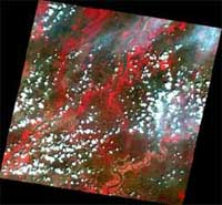
The change in radar backscatter is evedent from the multitemporal SAR composite images of the study area. Fig. 4 shows the multitemporal colour composite of JERS SAR images (Red - 2 Feb 97, Green - 24 Oct 97, Blue - 7 Dec 97). The locations of the different classes (I to VII) are marked on this image. Fig. 5 shows the colour composite image of ERS SAR images (Red - 7 Nov 96, Green - 23 Oct 97, Blue - 27 Nov 97), with the location of Class VIII marked.
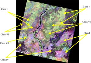
Figure 4. Multitemporal Composite of JERS SAR images (R-2 Feb 97, G-24 Oct 97, B-07 Dec 97) showing locations of different classes. The three display channels have been independently stretched to accentuate the different classes.
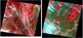
The values of radar backscatter coefficient for the different land cover classes are tabulated in Table 2. The time series of radar backscattering coefficient for these classes are shown in Fig. 6 and Fig. 7 for JERS SAR and ERS SAR respectively. The SPOT images acquired before, during and after the fire period are shown in Figs. 8, 9 and 10 respectively.
Table 2. Radar Backscatter of Different Land Cover Types in JERS and ERS Images.
| Class | Satellite | Radar Backscatter(dB) | ||
| Before-fire | Fire-burning | After-fire | ||
| I.Burnt Forests | JERS | -4.136 | -8.602 | -6.409 |
| ERS | -6.548 | -9.096 | -6.278 | |
| II.Cleared Land(Bright) | JERS | -6.290 | -7.046 | -6.437 |
| ERS | -6.240 | -7.537 | -5.746 | |
| III.Cleared Land (Dark) | JERS | -6.796 | -9.573 | -8.139 |
| ERS | -6.148 | -8.738 | -6.280 | |
| IV.Paddy Fields | JERS | -10.052 | -12.125 | -11.227 |
| ERS | -8.405 | -10.176 | -7.033 | |
| V.Peat Swamp Forests | JERS | -6.407 | -6.713 | -6.165 |
| ERS | -5.817 | -6.954 | -5.203 | |
| VI.Secondary Forests | JERS | -7.960 | -8.317 | -8.216 |
| ERS | -6.770 | -7.734 | -5.466 | |
| VII.Unburnt River Banks | JERS | -7.114 | -6.843 | -7.212 |
| ERS | -6.079 | -6.410 | -6.183 | |
| VIII.Very Bright Lands | JERS | -6.965 | -6.413 | -7.531 |
| ERS | -7.588 | -4.398 | -4.338 | |
There are quite a number of differences between the ERS and JERS backscattering coefficients from various land cover classes. Except for two classes (Class VII and Class VIII), the C-band ERS SAR backscatter generally decreases during the fire period and increases after fire. For the L-band JERS SAR, only three classes (Classes I, III and IV) show a similar pattern while the backscatter of the other classes do not show significant changes. For the unburnt vegetation along the river banks (Class II), the C-band ERS SAR backscatter remains constant whereas for the cleared lands which appear very bright in ERS images (Class VIII), the ERS backscatter increases during fire and stay high after fire.
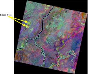
Figure 5. Multitemporal Composite of ERS SAR images (R-07 Nov 96, G-23 Oct 97, B-27 Nov 97) showing locations of class VIII.
The ERS backscatter shows a significant drop in values for Classes I to VI during the fire-period. This is expected as the vegetation on the ground has been destroyed resulting in weak backscattering. The radar backscatter signals increase very substantially when the fire has stopped burning. The radar backscatter signal after fire is equal to or higher than the level before-fire. The strong backscatter is possibly due to the dead vegetation stands on inundated or moist ground, resulting in an efficient double-bounce scattering configuration for radar backscattering. The inundated ground is probably due to the brief period of rains during the delayed wet season in late November/December [4]. For JERS SAR, Class I (Burnt Forests), Class III (Cleared Dark Lands) and Class IV (Paddy Fields) have the same pattern of change in the radar backscatter signal but the increse in backscatter after fire is not as substantial when compared to the case of ERS. Having a longer wavelength, L-band microwave has stronger penetration depth that results in less sensitivity to the moisture conditions on the ground. Class II (Cleared Bright Lands), Class V (Peat Swamp Forests) and Class VI (Secondary Forests) have little change in their radar backscatter values throughout the three different periods. Class VIII shows an atypical backscattering pattern in the ERS images. Its backscatter increases strongly during fire and stay constant after fire. From the SPOT images, this class does not show any different features than Class II, i.e. land cleared by fires between the grids of irrigation channels. The reason for its bright appearance is not understood.
Figure 6: Radar Backscatter Signatures of JERS images over different period of time (1 – Before-fire, 2 – Fire-burning, 3 – After-fire)
Figure 7 : Radar Backscatter Signatures of ERS images over different period of time (1 – Before-fire, 2 – Fire-burning, 3 – After-fire)
 |
 | |
| Fig. 8 : SPOT image of the study area acquired on 06 Jun 1997 | Fig. 9 :SPOT image of the same area acquired on 08 Sep 1997 | Fig. 10 : SPOT image of the area acquired on 20 Nov 1997 |
Conclusions
The change in ERS and JERS SAR backscatter of several land cover classes during the fire events in 1997 has been studied. Typically, for C-band ERS SAR, the backscatter of the fire affected areas decreases during fire and increases shortly after the fires, when the land becomes moist due to the rains. However, for the L-band JERS SAR, the backscatter typically does not vary significantly during and shortly after the fire periods.
References
- S. C. Liew, O. K. Lim, L. K. Kwoh and H. Lim, "A study of the 1997 forest fires in South East Asia using SPOT quicklook mosaics", Proc. 1998 Int. Geosci. Remote Sensing Symp., Vol. 2, 879-881, 1998.
- S. C. Liew, L. K. Kwoh, K. Padmanabhan, O. K. Lim and H. Lim, "Delineating land/forest fire burnt scars with ERS interferometric synthetic aperture radar",. Geophysical Research Letters, 26(16), 2409-2412.
- S. C. Liew, L. K. Kwoh, K. Padmanabhan, O. K. Lim and H. Lim, "Monitoring vegetation cover changes in peat swamp area of Central Kalimantan using ERS interferometric synthetic aperture radar", Paper Presented at the International Conference and Workshop on Tropical Peat Swamps - Safeguarding a Global Natural Resource, 27-29 July 1999, Penang, Malaysia.
- S. Couturier, S. C. Liew, M. Nakayama and H. Lim, "Monitoring vegetation regeneration in fire-affected tropical forests using ERS/JERS synthetic aperture radar", Proc. 1999 Int. Geosci. Remote Sensing Symp.