| GISdevelopment.net ---> AARS ---> ACRS 1999 ---> Forest Resources |
Researches on Monitoring by
Remote Sensing the Tropical Forests in Hainan Island, China
Li Xueqian
Hainan Provincial Meteorological Bureau, No. 60 Haifu Road, Haikou 570203
Tel: (0898) 5341779 BP: 95951-5891598
E-mail: Lxueqian@public.hk.hi.cn
Hainan is located in the southernmost part of
China,at 18 · 10' -20 · 10'N and 108 · 37'-111 · 03' E.The coastline of Hainan Island is
1,528km.The area of the island is 33,920km2 ,accounting for
42.4% of the total tropical area of China(80,000km2 ).Hainan is
the second largest island in China ,next to Taiwan. Hainan Provincial Meteorological Bureau, No. 60 Haifu Road, Haikou 570203
Tel: (0898) 5341779 BP: 95951-5891598
E-mail: Lxueqian@public.hk.hi.cn
Hainan Island used to historically boast dense original tropical forests due to its special geographical environment. Before 1938, the covering area of the tropical forests in the island made up 46% of the total area of the island. In the period of past half century and over, the forest resources here were destroyed severely because of felling a great deal of trees by humankind. At present, the covering area of the forests in the island accounts for only 1.89% of the total area of the island. Therefore, it is an important measure to protection and development of the tropical forests to provide, accurately and in time, the monitoring information on local forests for the governmental departments concerned by using an advanced technique.
In the present study, the data source from LANDSAT-5TM was used as a major information source. The earth-surface objects in the forest regions were classified by using the combined characteristics of the wave spectra from the earth-surface objects as a classification evidence and in accordance with the possibility of the present remote sensing technique and systematic software as well as the requirements of the services and tasks concerned. 15 types are defined .They are virgin forest ,many-year-long secondary forest ,median-class secondary forest, low-quality secondary forest ,bush ,artificial forest ,grassland, agricultural land, heavily burnt forest ,lightly burnt forest ,heavily bare land,lightly bare land , quarry ,water body and settlement.
The earth-surface objects are usually characterized by their own distinct reflection and radiation in wave spectra. The radiation and absorption of an electric magnetic wave from a substance are caused by vibration of atoms ------ the smallest micro-particles constituting a substance, molecular rotation and transition in energy level of electrons. In conversion of a high energy status into a low one, energy should be released and electric magnetic wave be radiated of a certain wavelength; in conversion of a low energy status into a high one, energy should be absorbed from the outside. Therefore, any objects themselves have the capability and characteristic of radiating, absorbing and reflecting an electric magnetic wave. So, different objects may be distinguished according to the difference in the characteristics of the spectra of electric magnetic waves received by a remote sensing instrument. The determination of the brightness values of the wave spectra from the various forest regions within the limits of the wave bands 1----7 ( except the wave band 6 ) in the stretched images obtained each year was carried out by using a computer. The reflecting rates of the brightness were calculated by the following equation:
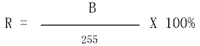
R -reflecting rates of the brightness
B -image element brightness value
It is discovered through comparison that the variation of the reflecting curve of lightness value(100%)of different earth-surface objects is very visible(shown in the figure)
It was found through comparison and analysis of the rates that the reflecting curves of the brightness from various earth-surface objects varied obviously and the most significant difference was manifested at the wave band 4 (0.76-----0.90 um) especially. The reflecting rate of the brightness from the original natural forests and many year’s secondary forests at the wave band 4 was below 50%, this not only reflected the characteristics of the healthy plants themselves in wave spectra but also was correlated with a higher canopy density in the forest regions and a higher moisture content of the plants. With increase in the brightness value, transition of the vegetation from forest land type to grass land type took place. Thereby, we came to the conclusion that the more the conditions of the plant habitats are dry, the more the reflecting rate of the plants is high. Our practices have shown that the brightness value of the herbage or broadleaf herbage is the highest at the wave band 4 (without exclusion of the influence of bare land background with a high brightness value ), reaching 90% and over; that the brightness value from the brush and poorer secondary woods ( belonging mostly to broadleaf woods ) takes second place, reaching 50----80%; that in general, the average brightness value from deciduous broadleaf plant community at the wave band 4 is 30----40% higher than that from evergreen broadleaf plant community ( including narrow-leaf plant community ); that the brightness value from broadleaf tree species is higher than that from narrow-leaf tree species; that the highest and lowest brightness values are revealed at different wave bands in the bare land, lightly bare land and shadow due to no vegetation or being unable to reflect vegetation within them; and that the brightness value from other earth-surface objects, such as water body, paddy field and original forests, etc. reduces with increase in their moisture content.
Light(100%)
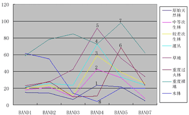
Legend: 1.virgin forest. 2.median-class secondary forest. 3.low-quality secondary forest. 4.bush. 5.grassland. 6.heavily burnt forest. 7.heavily bare land. 8.water body.
The wave band 3 ( 0.63----0.690 um ) is the better absorption zone of chlorophyll. The chlorophyll in plants has such forms as a, b, c, d. From the amount and action, the curves of the reflecting spectra mainly from the chlorophyll a and b have more influence. Among them, the chlorophyll a has the best absorption at the place between 0.68----0.70 um. To assimilate a molecule of carbon dioxide and release a molecule of oxygen by chlorophyll needs to absorb eight light quanta ( photon ), the total absorption rate being able to reach 90% or so, thereby forming a slope and valley pattern at the place between 0.68 and 0.70 um. From the beginning of 0.68 um, the light absorption rate of plants drops sharply with increase in wavelength.
The reflecting brightness curve of the plants at the wave band 7 ( 2.08----2.35 um ) assumes a low and middle brightness values, and the characteristic is correlated with the specific property of the wave spectra of the plants and their moisture content. For example, the water body and woodland all belong to the earth-surface objects with a lower reflecting rate (brightness rate between 5% and 34% ); in light of the law, the plant populations which had different moisture content and different canopy density were rearranged according to the moisture content and canopy density, so as to reflect the combined characteristics of the vegetation types in the forest lands through the senses once more.
The reflecting rate of the non-woodlands, especially the severely and lightly fired woodlands, seriously and lightly bare lands and stone pits was the highest at the wave band 5 ( 1.55---- 1.75 um ); also, the band had a better reflection to the vegetation, but a less obvious manifestation compared with the wave bands 3, 4, and 7.
Through analyses on the above spectrum lightness values and after experiments on various combinations of wave bands ,it is believed that Wave Band Combinations 7(R),4(G),3(B) and 4(R),5(G),3(B) are of the optimum reflectance of the characteristics of plant classification in the target areas .The adoption of natural color analogue not only meets the way of sense of sight but also benefits classification and interpretation.
Experience shows that monitoring of and research on forest types and environment status by using the remote-sensing technology is no doubt a rapid, economic and accurate advanced means, which is superior to traditional monitoring methods.