| GISdevelopment.net ---> AARS ---> ACRS 1999 ---> Environment |
An Entropy Method to Analyze
Urban Sprawl in A Rapid Growing Region Using TM Images
Anthony Gar-on YEH
Center of Urban Planning and Environmental Management
University of Hong Kong, Hong Kong
Fax: (+852) 2559-0468 Tel : (+852) 2859-2721
E-mail : mailto:kdxugoy@hkucc.hku.hk
Xia LI
Guangzhou Institute of Geography, Guangzhou 510070, PR China
Fax: (8620) 87605012 Tel : (8620) 87605015
E-mail: xlib@gis.sti.gd.cn
Abstract
Center of Urban Planning and Environmental Management
University of Hong Kong, Hong Kong
Fax: (+852) 2559-0468 Tel : (+852) 2859-2721
E-mail : mailto:kdxugoy@hkucc.hku.hk
Xia LI
Guangzhou Institute of Geography, Guangzhou 510070, PR China
Fax: (8620) 87605012 Tel : (8620) 87605015
E-mail: xlib@gis.sti.gd.cn
This paper presents the entropy method to analyze urban sprawl based on the integration of remote sensing and GIS. The advantages of the entropy method are it simplicity and easy integration with GIS. The measurement of entropy is devised based on the tow location factors distance from town centers and distance from roads, to reveal and capture spatial patterns of urban sprawl. The application of the method in the Pearl River Delta, one of the fastest growing regions in China has demonstrated that it is very useful and effective for the monitoring of urban sprawl. It provides a tool of the quantitative measurement that is needed for rapidly growing regions in identifying internal variations and temporal change of urban sprawl patterns.
1. Introduction
Remote sensing data are especially important in the areas of rapid land use changes where the updating of information ti tedious and time-consuming. The monitoring of urban development is mainly to find out the type, amount, and location of land conversion. There are numerous studies in using remote sensing to monitor land user change and urban development ( Howarth, 1986 ; Fung and LeDerw, 1987; Eastman and Fulk , 1993; Jensen et al., 1993, 1995; Li and Yeh, 1998). Various techniques haven been developed to improve change detection accuracy , including image differencing ( Toll et al., 1980) , image rationing ( Nelson , 1983), post -classification comparisons ( Howarth and Wickware, 1981), masking method ( Pilon et al., 1988) ,and principal component analysis ( Fung and LeDrew, 1987; Li and Yeh , 1988).
In this study, the main focus is one the urban sprawl that has appeared in the Pearl River Delta, China. The region has witnessed widespread ' leap-frog ' development due to lack of proper planning. The fragmented conversion of agricultural land into urban use discords with rationalized land development patterns ( Yeh and LI, 1998) . many advantages have been associated with a larger patch of land use , such as reduction of environmental cost and development cost ( Buiton, 1994). There is also a long history in estimation of landscape change and its impacts on wildlife ( Mc Arthur and Wilson, 1967). It is found that fragmentation of land user in harmful to biological conservation as well as to urban growth. A larger area usually contains a grater diversity of habitats because it provides great spatial and temporal variation in resources ( Mc Arthur and Wilson, 1967 ; O'Connor et al, 1990) .
2. Methodology
Although various studies have been dedicated to the measurement or urban form, they have limitations in capturing the characteristics or urban sprawl. There methods are just developed in the context of image analysis or fractal theory ( Webster, 1995; Batty and Longley, 19940; in this paper, an alternative technique, entropy, specifically to measure the extent or urban sprawl is developed with the integration of remote sensing and GIS. The measurement is directly carried out with in GIS to facilitate the convenient access to GIS spatial database. The measurement is based on entropy theory, as Shannon 's entropy (E) can be used to measure the degree of spatial concentration and dispersion exhibited by geographical variable ( Xi) ( Theil, 1967; Thomas, 1981 ) . Entropy is calculated by :
Where pi =
 and xi is
the observed value in the it zone in a total of n zones. It ranges from 0
to 1. if the distribution is maximally concentrated in one region, the
lowest value, zero. Will be obtained. Conversely, an evenly disperse
distribution across space will give a maximum value of 1.
and xi is
the observed value in the it zone in a total of n zones. It ranges from 0
to 1. if the distribution is maximally concentrated in one region, the
lowest value, zero. Will be obtained. Conversely, an evenly disperse
distribution across space will give a maximum value of 1. The major difference between entropy and entropy and traditional indices of spatial dispersion is that its value is invariant with the value of zones, the number of observation (n) ( Thomas, 1981). In contrast, Gini coefficient or Lorenz curve, which has been widely used in geography to describe location pattern, has deficiency because the coefficient is sensitive to the size and shape of the area units of observation. The modifiable area unit problem may exert influences on the results of spatial analysis and lead to the loss of detailed information ( Openshaw, 1991). However, there is no such problem when entropy is used.
In this study, the buffer function of GIS will be used to define buffers or zones for calculating entropy. This can allow some independent variables form GIS database to be easily embedded in entropy. Other morphological approaches have limitations to explore spatial relationships between urban sprawl and spatial factors because those methods are not directly developed within GIS. The information from GIS database is important because urban sprawl is always dependent on other geographical variables.
Since entropy can be used to measure the distribution of a geographical phenomenon, thus the measurement of the difference on entropy between time t+1 can t can be used to indicate the change in the degree of dispersal of land development or urban sprawl.
DE=(t+1)-E(t) (2)
The dispersal or urban areas from a town center will lead to an increase in the entropy value . the change of entropy can be used to identify whether land development is toward a more dispersed ( sprawl ) or compact pattern. The following section will discuss how to use the entropy method to measure the rapid urban sprawl in a fast growing region with the integration of remote sensing and GIS.
3. The Application
TM satellite images dated 10 December 1988. 13 October 1990 and November 1993 were used to estimate the amount or urban expansion and to measure and compare the spatial pattern of urban sprawl during the period. Principal component analysis of stacked multi-temporal images technique was used to obtain the land use classes and land use change ( Li and Yeh, 1988). It was found that the area for urban land use rapidly expanded from 18,351.4 ha. In 1988 to 19,604 ha. In 1990 and to 39,636.4 ha. in 1993. the annual growth rate of urban area was only 3.4% in 1988-90, but it surpassingly became 34% in 1990-93. spacious use of land resources has been identified as the land consumption per capita increased substantially from 128.4 m2 during 1988-1993, which were both much higher that athe national standard of 100m2. urban expansion had resulted in the loss of 13.2% of its total agricultural land.
It is easy to find that the urban sprawl is affected by some location factors-distance to urban centers and roads. Entropy should be calculated based on the distance variables to address the distance decay properties or urban sprawl. The influences of these locations factors was measured using the buffer functions of GIS. Two types of buffer zones wire devised o calculate densities of land development with regard to the two distance variables. Entropy based on the buffer functions is given as:
Where PDENi = DENi/
 DENi and DENi is the density of land
development. DENi equals to the amount of land development
divided by the total amount of land in the ith buffer in the ith buffer in
a total of n buffer .
DENi and DENi is the density of land
development. DENi equals to the amount of land development
divided by the total amount of land in the ith buffer in the ith buffer in
a total of n buffer . Two types of thematic layers are needed for the calculation of densities of urban sprawl in each buffer. The thematic layer or urban sprawl of each period were obtained by the classification of multi-temporal satellite images. The thematic layers of buffers were created respectively based on the proximity to town centers and roads using the buffer function s of GIS. The width of each buffer is 250 m , and each town has about 15-30 zones on average. The overlay of the urban images and the buffer images can capture the densities of urban sprawl in each buffer. The distribution of the densities over the buffers was obtained using the summary function of ERDAS IMAGINE 8.3. the summary function was used to produce cross-tabulation statistics that compare class value areas between tow thematic layers, including number of pixels ( or hectare ) in common and percentages. The entropy in terms or urban sprawl for each town in 1988, 1990 and 1993 was calculated according to the equation 3.
Three typical urban sprawl patterns can be identified in the towns of Dongguan from the analysis ( Figure 1). The first type is concentrated ( Low Development ) as represented by Hongmei which has only very limited land development in 1988-93 . the second type is Dispersed ( Medium Development ) as represented by Dalang which exhibited some dispersal away from the town center. The third type is Highly Dispersed 9 High Development ) as represented by Tangsha. It has an upward increase in the density of land development and dispersal of urban development away from the own center. There three types of urban sprawl patterns can be reflected from the entropy. In the first type of urban sprawl ( concentrated ), most of the land development is near the town center and the entropy is relatively small. Area farther away format he town center is not so favorable for land conversion and most of the land development is carried out only with in the distance very close to the town center. There is more spread land development in the second type ( Dispersed ) . the entropy is higher than that of the first type. For the third type or urban sprawl (Highly Dispersed ), land development spreads over the urban fringe and to the surrounding rural area and the entropy is the highest among the three types of urban sprawl.
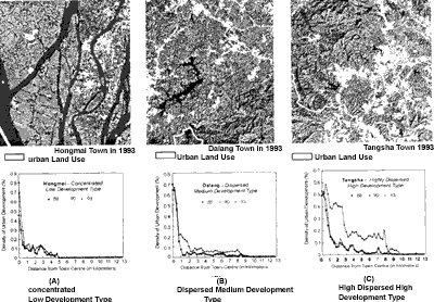
Figure 1. Three typical urban sprawl patterns
The temporal change of spatial patterns of urban development can be easily measured from the change in entropy. The increase of the value of at entropy indicates that there is an increase in urban sprawl and development tends to be more dispersed. It is found that the average increase in entropy was only 2.7% for the whole region during 1988-90. this means that there was only a slight trend of urban sprawl in this periojd. However, the average increase in entropy increased to 8.9% in 1990-93 as a result of rapid land development and property boon in 1992-93. there were some towns with negative figures during these periods, indicating relatively more concentrated development rather that dispersed development. Theses towns were minority among the 29 towns were minority among the 29 towns of Dongguan. There were 11 towns in 1988-90 and only 4( including the city proper ) in 1990-93 that had negative increases. This indicates that the majority of development is towards dispersed development rather than concentrated development. Zhangnutou, a town which is recently famous for the development of property markets for Hong Kong;s residents, had an increase of entropy as high as 24.1% in 1990-93,as compared with the average of 8.9% for the whole area. Two other towns, . Tangsha and Qingxi which are very close to Hong King, were also among those with a ahigh; ;increase of entropy with the rates of 18.1% and 24.9% respectively. Dalingshan and Dalang which are located in the hilly areas, however, also witnessed a high increase of entropy in 1990-93. the development sites in theses tow towns are scattered in the satellite images. The four towns that had negative increase of entropy in 1990-93 were Wangniudun, Daojiao, Hongmei and Xinwan. This means that land development in these towns was less dispersed this period.
4. Conclusion
The study shows that entropy is a good indicator to identify the spatial problems of land development. For the example, entropy based on distance from roads can be used t monitor urban sprawl along roads. Many development sites area just located along roads without a compact development pattern, resulting in wasteful user of land resources and increasing consumption of energy. Entropy is capable of identifying which town has better spatial efficiency in land development. Further more, the two-dimensional entropy space can be used to differentiate various growth patterns clearly. This provides a useful tool for government officials and planners to monitor land development process and find out land user problems.
The application of the method reveals that the Pearl River Delta has experienced severe urban sprawl in the early 90s with the lack or proper development control and management. The dispersed pattern of land development it identified by calculating the entropy from multi-temporal satellites images. The entropy of land development has increased from 2.75 in 1988-90 to 8.9% in 1990-93 as urban areas quickly dispersed to the agricultural areas. Rapid urban expansion is inevitable in the Pearl River Delta during the fast growing period, both the patterns of urban sprawl should be under control to conserve land resources. Urban sprawl which does not take into considerations of physical properties of land, such as soil fertility, has produced severe impacts on agricultural production. According to the findings using entropy. Some towns of the study area have unusual high degree or urban sprawl. There is an urgent need to control such development patterns so that further economic growth in the region can be sustained.
Acknowledgement
This study is supported by the funding from the Croucher Foundation, Hong Kong.
Reference:
- Batty, M., and P.A. Longley, 1994. Fractal Cities" A Geometry of Form and Function. Academic Press, London.
- Buition, P/L/, 1994 . A Vision for Equitable Land Use Allocation , Land Use Policy, 12(1):63-68.
- Eastman, J.R., and M.Fulk, 1993. Long Sequence Time Series Evaluation Using Standardized Prinicple Components. Photogrammetric Engineering and Remote Sensing , 59(6): 991-996.
- Fung, T., and E. LeDrew, 1987. Application of Principal Components Analysis Change Detection, Photogrammetric Engineering and Remote Sensing , 53(12):1649-1658.
- Howarth, P.J., 1986. Landsat Digital Enhancement For Change Detection In Urban Environment, Remote Sensing Of Environment, 13:149-160.
- Howarth, P.J., and G.M. Wickware, 1981, Procedures For Change Detection Using Landsat Digital Data, International Journal Or Remote Sensing, 2(3): 277-291.
- Hensen, J.R., D.J. Cowen, J.D. Althausen, SX. Narumalani, and O. Weatherbee, 1993. An evaluation of the coast watch change detection protocol in south carolina. Photogrammetric engineering and remote sensing, 59(6):1039-1046.
- Jensen, J.R., k. Rutchey, M.S. Koch, and S. Narumalani, 1995. Inland Wetland Change Detection In Everglades Water Conservation Area 2a Using A Time Series Of Normalized Remotely Sensed Data, Photogrammetric Engineering And Remote Sensing, 61(2):199-209.
- Li, X., and G.A.O. Yeh , 1998, Principal Component Analysis Of Stacked Multi-Temporal Images For Monitoring Of Rapid Urban Expansion In The Pearl River Delta International Journal Or Remote Sensing, 19(8): 1501-1518.
- McArthur, R.H., and E.O. Wilson, 1967. The theory of island biogeography, princetion university press, princetion, NJ.
- Neson, R.F., 1983, Detecting Forest Canopy Change Due To Insect Activity Using Landsat Mss , Photogrammetric Engineering And Remote Sensing, 49(9): 1303-1314.
- O'Connor, K.F., F.B. Overmars, and M.M. Ralston, 1990. Land Evaluation for Nature conservation, caxton press Ltd., Willington.
- Openshaw S., 1991, A Spatial analysis research agenda, handling geographical information: methodology and potential applications. (I. Masser, and M. Blackmore, editors), John Wiley & Sons, Inc., New York, pp 18-37.
- Pilon, P.G., P.j. Howarth,a dn R.A. Bullock, 1988. an Enhanced Classification Approach to Change Detection in Semi-arid Environments, Photogrammetric Engineering and Remote Sensing , 54(12): 1709-1716.
- Theil, H., 1967. Economics and information Theory. North-Holland , Amsterdam .
- Thomas, R.W., 1981. Information statistics in Geography. W.H. Hutchins & Sons, Norwich .
- Toll, D.L., 1980. Urban Area Update Procedures Using Landsat Data, Proceedings, American Society of Photogrammetry, RS-E-1-17.
- Webster, C.J., 1995. Urban Morphological Fingerprints, Environments and Planning B, 22: 79-297.
- Yeh, A.G.O.and X. Li, 1998. sustainable Land Development Model for Rapid Growth Areas using GIS , International Journal of Geographical information Science ,12(2) 169-189.