| GISdevelopment.net ---> AARS ---> ACRS 1999 ---> Environment |
Estimation of Emission
changes about green house effect gasses by land-cover changes using remote
sensing and GIS in Sumatra Island, Indonesia
Lilik Budi Prasetyo*,Genya
Saito** and Haruo Tsuruta**
* Bogor Agriculture University, Indonesia
** National Institute of Agro-Environmental Sciences, Japan
Tel:+81-298-38-8192 Fax:+81-298-38-8199
E-mail: genya@niaes.affrc.go.jp
Keywords: Greenhouse effect gases, Remote
Sensing, GIS, Sumatra Island, Spatial database
* Bogor Agriculture University, Indonesia
** National Institute of Agro-Environmental Sciences, Japan
Tel:+81-298-38-8192 Fax:+81-298-38-8199
E-mail: genya@niaes.affrc.go.jp
Introduction
Deforestation, conversion of forest into non-forest land cover, especially in tropical forest area has been an international concern. It was estimated that tropical forest was deforested by 6 – 16.8 million hectares per year (Grainger, 1993; Barbier et. all., 1991; Myers, 1994). Since forest hold the most carbon in terrestrial ecosystem, such changes give significant impact on the net increase of atmospheric carbon. In addition, land cover changes results in greenhouse effect gases (GHG:CO2, N2O, CH4) dynamics.
GHG emission of soil surface is influenced by several factors such as land cover types, climatic factors, biological factors and physical environment factors. Emission measurements usually are conducted at a point location, therefore problem arise when emission estimation will be used for scaling up into a broader areas. The research aimed at the development of Spatial database to assist the regional estimation of aboveground carbon stock loss and soil surface GHG emission changes caused by land cover changes using GIS and Remote Sensing. As a case study land cover change between 1992 and 1995 of Pasir mayang area and 1986 to 1992 of Jambi Province, Indonesia will be evaluated.
Research method
Development GHG database at Pasir mayang area
Using LANDSAT/TM data, we determined land cover of Pasir mayang area in 1992 and 1995. Pasir mayang area is 33km (east to west) and 20km (north to south) and is listed as Fig. 1. In the area, estimation of total above ground carbon stock is calculated by multiplying the value of ha by total area of each land cover. The same method was applied for calculating the total emission of GHG.
Development GHG database at Jambi Province
The study area is located in Jambi Province, between 0° 45’ and 20° 45’ latitude south; 101° and 104° 55’ longitude east (Fig. 1). The total area is 48,715 sq. km. It ranges from swampy coastal plains in the east to more than 1,000 meters above the sea level in the western part. According to statistical data, in 1995 the population of Jambi was 2.18 Million and has increased more than two fold compared to 1971 data (Bappeda Jambi 1995 and 1988).
The research is initiated by the development land cover maps, and followed field measurement. Spatial database (land cover) construction was conducted in Forest Ecology and Remote Sensing Lab. of Regional Center for Tropical Biology (BIOTROP), and Remote Sensing Research Unit of National Institute of Agro-environmental Sciences, Japan. Field measurements (above ground biomass, and GHG flux) were conducted by BIOTROP, Impact Center of South East Asia and National Institute of Agro-environmental Sciences, Japan.
Land cover map construction
Spatial database of Land cover were developed based on land cover maps in 1986 and 1992 at scale 1 : 250,000 published by BIOTROP. These two maps were made based on visual interpretation of LANDSAT and SPOT.
Bio-mass estimation (Aboveground carbon stock)
Weight of sample components of the tree i.e. timbers, stems, branches, twigs, leaves and roots of primary forest, secondary forest and logged over forest were estimated by using equation developed by Kira and Iwata (1989). Tree biomass for one hectare plot was calculated by multiplying biomass of each tree with the number of tree per hectare. To get aboveground carbon stock the biomass weight was multiplied by factor of 0.5.
Soil GHG flux measurement
Flux of carbon dioxide, nitrous oxide and methane of soil surface were measured at various land cover types in order to obtain the estimates of GHG emissions by the ground survey group of our project.
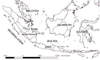
Fig. 1 Pasir mayang area and Jambi Province
Result and Discussion
Developed GHG database at Pasir mayang area
The land cover maps of Pasir mayang area in 1993 and 1995 were indicated as Fig. 2. Estimation of above ground carbon stock is calculated by multiplying the unite value by total area of each land cover using the land cover maps of Pasir mayang area in 1993 and 1995. The same method was applied for calculating the total emission of GHG. These results are shown as table 1 and table 2. Logged forest was the most dominant land-cover in Pasir mayang, followed by rubber and secondary vegetation (rubber jungle), fallow land (bush/shrubs), grassland and bare land (clear cut area) (Table 1).
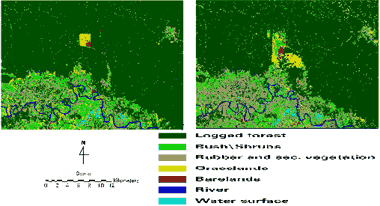
Fig. 2 Land cover maps of Pasir mayang area and changes in 1993 and 1995
Table 1 Land cover and above ground carbon stock changes in Pasir Mayang between 1993 – 1995
| Land cover | Carbon stock per ha (ton/ha) | Area in 1993 (ha) | Total above ground Carbon stock in 1993 (ton) | Area in 1995 (ha) | Total above ground Carbon stock in 1995 (ton) |
| Logged forest | 155.2 | 68,529.5 | 10,634,270.75 | 63,235.5 | 9,812,758.4 |
| Bush/Shrubs | 15.0 | 10,224.8 | 153,372.0 | 10,450.3 | 156,754.5 |
| Rubber and sec. Vegetation. | 35.5 | 6,541.8 | 232,233.9 | 11,414.3 | 405,207.7 |
| Grass land | 6.0 | 3,156.5 | 18,939.0 | 3,468.3 | 20,809.8 |
| Bare land | 0.0 | 986.3 | 0 | 870.5 | 0 |
| Total in 1993 | 89,438.9 | 11,038,815.7 | 89,438.9 | 10,395,530.4 |
Table 2 Soil green house gas emission changes of Pasir Mayang between 1993 and 1995
| Land-cover | Carbon dioxide (ton/hour) | Nitrous oxide (kg/hour) | Methane (kg/hour) | |||
| 1993 | 1995 | 1993 | 1995 | 1993 | 1995 | |
| Logged forest | 241.4 | 222.8 | 7.343 | 6.776 | -9819.3 | -90607.7 |
| Fallow land | 59.4 | 60.7 | 2.041 | 2.086 | -4.5 | -4.6 |
| Rubber and sec. vegetation | 31.0 | 54.0 | 1.328 | 2.317 | -1.3 | -2.2 |
| Grassland | 19.1 | 20.9 | 0.347 | 0.381 | 0.0 | 0.0 |
| Bareland | 6.1 | 5.4 | 0.326 | 0.117 | -73.2 | -64.6 |
| Total | 357.0 | 363.8 | 11.194 | 11.679 | -9898.3 | -9132.1 |
The measurements were made in Jan., Feb., Mar., June, July, Aug., Sep., Oct., Nov. and Dec
Between 1993-1995, logged forest area decreased of about 5,300 ha, while rubber jungle and fallow land increased 4,872 ha and 225 ha, respectively. Due to this, above ground carbon stock of the area decreased from 11.1 million ton to 10.4 million ton, or have loss of about 0.7 million ton.
Table 2 summarized the GHG emission of soil in 1993 and 1995. Comparison of the total GHG flux of the two period time studies based on land-cover have showed that there was an increase flux of nitrous oxide and carbon dioxide and absorption reduction of methane.
Developed GHG database at Jambi Province area in Sumatra
Land cover changes
Land cover patterns in 1986 and 1992 is presented in Table 3. Proportion of primary forest decreased from 33.9% in 1986 to 25.8% in 1992. Fallow lands (shrubs) decreased from 19.3% to 12.5% in 1992. Further analysis of each land cover types is presented in Fig. 3. It shows that about 24% of primary forest area were converted into logged forest, shrubs (fallow lands), cash crop plantation, cultivated and settlement areas. About 30% of logged forest were converted into shrubs, cash crop plantation, a mixture of cultivated and settlements.
Table 3 Land cover and above ground bio-mass changes between 1986 and 1992
| LAND COVER | 1986 | 1992 | ||||
| Area (sq. km) | % of total area | Total carbon (106 ton) | Area (sq. km) | % of total area | Total carbon (106 ton) | |
| Primary forest | 16521.20 | 33.91 | 416.89 | 12569.86 | 25.80 | 317.19 |
| Secondary forest | 0.00 | 0.00 | 0.00 | 1274.34 | 2.62 | 7.40 |
| Logged forest | 10022.39 | 20.57 | 155.53 | 12448.65 | 25.55 | 193.18 |
| Fallow land | 9401.68 | 19.30 | 14.10 | 6072.66 | 12.47 | 9.11 |
| Grassland | 535.99 | 1.10 | 0.32 | 523.19 | 1.07 | 0.31 |
| Bare land | 3.67 | 0.01 | 0.00 | 3.67 | 0.01 | 0.00 |
| Cash crops plantation | 912.78 | 1.87 | 2.56 | 3303.17 | 6.78 | 9.25 |
| Paddy field | 1002.78 | 2.06 | 0.75 | 649.16 | 1.33 | 0.49 |
| Upland field | 0.00 | 0.00 | 0.00 | 235.84 | 0.48 | 0.18 |
| Cultivated lands and Secondary Vegetation | 7036.29 | 14.44 | 24.97 | 7933.39 | 16.29 | 28.16 |
| Cultivated lands and Settlement | 1339.84 | 2.75 | 0.50 | 1630.68 | 3.35 | 0.61 |
| Urban area | 0.00 | 0.00 | 0.00 | 132.17 | 0.27 | 0.00 |
| Water surface/lake | 42.41 | 0.09 | 0.00 | 42.27 | 0.09 | 0.00 |
| No data | 1896.60 | 3.89 | - | 1896.6 | 3.89 | - |
| Total | 48715.65 | 100.00 | 615.62 | 48715.65 | 100.00 | 565.88 |
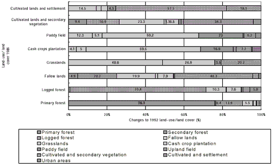
Fig. 3 Land cover Changes from 1986 to 1992
Aboveground carbon stock changes
Aboveground carbon content estimation of each land cover was calculated by multiplying the area of each land cover with carbon stock per unit area. Table 3 has showed the changes of aboveground carbon due to land cover changes. Total above ground carbon stock decrease from 6.16 x 10⁸ ton in 1986 to 5.66 x 10⁸ ton in 1992 or loss of about 0.50 x 10⁸ ton within 6 years equal to 8.3 millions ton per year. The loss of aboveground carbon was mainly came from primary forest conversion. IPCC have divided the loss of aboveground carbon content into on site and off-site release. These two categories were classified further into direct burning (fuel wood and slash and burn agricultural) and decomposition process release of unburned biomass (Houhton et.al., 1996). Thus the amount of carbon and GHG released to the atmosphere were depended on these processes. Estimation of the amount carbon and GHG release need yearly basis time series of spatial data and the information on commercial wood and fuel wood harvest, and burning efficiency data of each land cover type.
Soil Greenhouse gas emission changes
GHG flux of soil varies depend on type the site condition and season. The comparisons below were made based on flux measurement conducted in November 1997 in several sites of Jambi Province. The calculation results of total flux based on 1986 and 1992 land cover data for major land cover presented in Table 4. Comparison of the total GHG flux of the two periods of time studies could not be performed since there are still no information on GHG flux of soil surface under cash crops plantation and secondary forest. However, it seems that the conversion of natural forest will cause on the decrease of methane gas absorption and induce the increase of nitrous oxide and carbon dioxide flux emission.
Table 4 Greenhouse gases flux changes between 1986 and 1992
| Land-use/Landcover class | Total flux of CO2 (mg/day) | Total flux of N2O (mg/day) | Total flux of CH4 (mg/day) | |||
| 1986 | 1992 | 1986 | 1992 | 1986 | 1992 | |
| Primary forest | 1.69x10¹⁴ | 1.28x10¹⁴ | 3.2x10⁹ | 2.43x10⁹ | -1.45x10¹⁰ | -1.10x10¹⁰ |
| Secondary forest | 0.00 | 5.75x10¹² | 0.00 | 7.03x10⁸ | 0.00 | -3.36x10⁹ |
| Logged forest | 1.24x10¹⁴ | 1.54x10¹⁴ | 2.48 x10⁹ | 3.08x10⁹ | -1.04x10¹⁰ | -1.29x10¹⁰ |
| Fallow land | 1.31x10¹⁴ | 8.46x10¹³ | 4.51 x10⁹ | 2.91x10⁹ | -1.00x10¹⁰ | -6.47x10⁹ |
| Grassland | 7.76x10¹² | 7.58x10¹² | 1.42 x10⁸ | 1.38x10⁸ | 0.00 | 0.00 |
| Bare land | 2.44x10¹⁰ | 2.44x10¹⁰ | 5.67x10⁵ | 5.67x10⁵ | -6.25x10⁵ | -6.25x10⁵ |
| Cash crops plantation* | 1.87x10¹³ | 6.75x10¹³ | 4.68x10⁸ | 1.69x10⁹ | 0.00 | 0.00 |
| Paddy field | - | - | 9.63x10⁷ | 6.23x10⁷ | 7.22x10⁸ | 4.67x10⁸ |
| Upland field | 0.00 | 2.41x10¹² | 0.00 | 4.03x10⁷ | 0.00 | 0.00 |
| Cultivated land and Secondary vegetation | 8.00x10¹³ | 9.02x10¹³ | 3.43 x10⁹ | 3.87x10⁹ | -3.33x10⁹ | -3.75x10⁹ |
| Cultivated lands and Settlement | 6.85x10¹² | 8.33x10¹² | 1.16 x10⁸ | 1.41x10⁸ | 0.00 | 0.00 |
| Total flux | 536.5x10¹² | 548.3x10¹² | 14.4 x10⁹ | 15.1x10⁹ | -37.5x10⁹ | -37.0x10⁹ |
* : assumed flux of CH4 and CO2 of cash crops plantation are equal upland, while flux of N2O is equal to three times of upland field flux due to intensive fertilizer application.
References
- Adger., W. Neil and K. Brown. 1994. Land-use and the causes of global warming. John Wiley & sons. New York. 27I p
- Ball, D. and R. Babbage. 1989. Geographical information system; defense application. New South Wales. Macathur Press. 257 p
- Bappeda Jambi. 1985 and 1988. Jambi province statistics. Bappeda (in Indonesian)
- Barbier, E.B, Joanne C. B. and A. Markandya. 1991. The economic of tropical deforestation. Ambio 20 (2) : 55 – 58
- Burrough, A. 1986. Principles of geographical information system for land resources assessment, Oxford, Clarendon Press. Oxford, 193 p
- Houghton, J.T., et.al. Greenhouse gas inventory reference Manual : page 5.1 – 5.74
- Ikeda, H., Okamoto, K., and Fukuhara, M., 1994, Estimation of carbon budgets in croplands using Landsat TM data. In Proceedings of the 7th IUAPPA Regional Conference on Air Pollution and Waste Issues, held on November 2-4, 1994, Taipei, I, 139-146.
- Khalil, M.A.K., R.A. rasmussen, M.X. Wang and L.Ren. 1991. Methane emissions from rice fields in china. Environ. Sci. Tech. 25: 979-981
- Kira, Tatuo and Keiji Iwata. 1989. Nature and Life in Southeast Asia Volume IV, 1989. Fauna and Flora Research society, Kyoto, Japan.
- Mahmood, N. etc. 1991. Characterization of environmental changes using remote sensing technique - a case study applied to Klang valley area. in Application of remote sensing in Asia and Oceania - Environmental change monitoring.. (Murai eds) Asian Assoc. on Remote Sensing
- Maguire, J. etc. 1991. Geographical information system; principles and application. New York. John Wiley and Sons Inc. 588p
- Myers, N., 1994. Tropical deforestation; rates and pattern in The causes of tropical deforestation (Brown, K. and D.W. Pearce eds.) England, UCL Press, pp 27 – 40