| GISdevelopment.net ---> AARS ---> ACRS 1999 ---> Environment |
Estimation of Atmospheric
Aerosol Depth with SPOT Satellite Data
Gin-Rong Liu*, Tang-Huang
Lin** and A. J. Chen*
* Center for Space and Remote Sensing Research,
National Central University Chung-Li 320,
China Taipei;
E-mail: grliu@csrsr.ncu.edu.tw
** Institute of Space Science, National Central University Chung-Li 320, China Taipei
Keywords: Aerosol optical depth,
Structure function, SPOT* Center for Space and Remote Sensing Research,
National Central University Chung-Li 320,
China Taipei;
E-mail: grliu@csrsr.ncu.edu.tw
** Institute of Space Science, National Central University Chung-Li 320, China Taipei
Abstract
In applying the contrast method, such as the structure function method, to estimate the atmospheric aerosol depth with satellite data, a uniform landcover area in image is chosen as a test area to avoid the probable errors induced by the poor structure function patterns. Unfortunately, the uniform area is not easy to pick up or does not exist in some complex landuse regions, such as in Taiwan. In order to pursue the potential application of the structure function method, especially for complex terrain areas, our study extends the original single-directional structure function to multi-directional, and introduces an “optimal number” into our procedure to improve the accuracy of aerosol depth estimation. The comparison between the estimated and sunphotometer-observed aerosol depths shows that the accuracy is improved significantly by our improvements.
Introduction
Basically, satellite remote sensed data are affected mainly by the scattering effects of atmospheric molecular and aerosols in the visible band, Fraser et al., 1984. Some atmospheric correction schemes have been proposed in applying to the satellite visible band data, such as Landsat and SPOT images in the past studies(Griggs, 1975; Mekler et al., 1977; Tanre et al.,1988; Rao et al., 1989; Holben B. N. et al., 1990 and Liu et al., 1997). Some studies showed that the structure function method can be used to estimate accurately the atmospheric aerosol depth, however obvious errors could be induced in some cases by the bad structure function patterns. Further analysis indicates that the abnormal patterns probably are caused by the change of satellite observation geometry, the change or the complexity of landcover. Therefore, the aim of this study is to try to provide a solution to reduce the probable errors in applying the structure method and improve the accuracy of optical depth estimation.
Methodology
Assuming the surface observed by satellite sensor is Lambertian, the apparent reflectance, r*, observed by satellite is (Tanre et al., 1988)

where ms=cosqs,qs is the solar zenith angle, mv=cosqv ,qv is the observed zenith angle, ra is the atmospheric reflectance,f is the relative azimuth angle between the sun and the satellite, t is the optical depth, r is the surface reflectance, T is the transmittance from the sun to surface, s is the atmospheric albedo, <r> is the mean surface reflectance, and td is the diffused transmittance from surface to satellite.
The multi-scattering effect of the surface and atmosphere is small and can be neglected. In other words, <r>S=0. Assuming the <r> values to be the same in local area, the apparent reflectance difference between two neighboring pixels, (i,j)
 (i,j+d), in distance d can be written as
D r*(i,j)=D r(i,j)T(ms)exp[-t/mv] (2)
where i, j are the row and column index of image, respectively. If we assume the D r(i,j) value being constant in time, the r*(i,j ) will be the function of t, which depends upon atmosphere condition. Tanre et al. (1988) has defined a structure function parameter, M, as
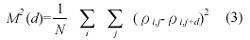
where N is the total pixel number in the test area. In their original method, a single direction difference is calculated in the structure function. However, in our study, we consider a multi-directional(i, j and cross(c) directions shown in Fig.1) structure function, which can be expressed as

and the structure function M * (d) derived by satellite observation can is written as
M*2(d)=M2(d)T2(ms)exp[-2t /mv] (5)
where M is the real surface structuren function.
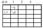
Figure 1 The directions of i, j and c of the multi-directional structure function.
If assuming the landcover remaining unchanged from t1 to t2 observation time, i.e. M 2 (d,t1)=M2 (d,t2), the relationship of observed structure functions between t1 to t2 is,
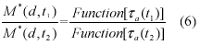
Equation (6) shows that if one of the aerosol optical depths in t1 or t2 is known, the other optical depth can be derived from satellite observation.
Analysis shows that the estimated optical depth could be different for different d values. In the general cases, the mean value of optical depths from d=1 to d=10 is used, but significant errors could be observed in some cases when the correlation is low for different distances. So, the “optimal number” is adopted to remove the abnormal structure function areas(Liu et al., 1997). The introduction of “optimal number can remove the poor structure functions and improve the accuracy of the optical depth estimation.
Data
This study used multi-temporal SPOT images to estimate the atmospheric aerosol optical depth. The data set includes 6 SPOT imageries acquired between April to August, 1998 covering Chung-Li area. The geometric information of the data set is shown in Table 1. Meanwhile, the sunphotometer data were collected at the same time. The aerosol depths derived from sunphotometer data were used to verify the accuracy of the method proposed in this study (Table 2).
Table 1. The geometric information of SPOT images used in this study
| Date | Local Time | View Angle | Solar Angle | ||
| Zenith | Azimuth | Zenith | Azimuth | ||
| 1998/04/24 | 02:23 | -29 | 193 | 24 | 117 |
| 1998/05/11 | 02:27 | -23 | 193 | 20 | 107 |
| 1998/06/27 | 02:24 | -30 | 193 | 21 | 89 |
| 1998/07/02 | 02:28 | -24 | 193 | 20 | 90 |
| 1998/07/30 | 02:59 | 31 | 193 | 15 | 110 |
| 1998/08/21 | 02:36 | -9 | 193 | 22 | 119 |
Table 2. Aerosol optical depth collected by sunphotometer.
| Date | 1020 nm | 870 nm | 670 nm | 440 nm |
| 1998/04/24 | 0.133 | 0.157 | 0.249 | 0.470 |
| 1998/05/11 | 0.272 | 0.326 | 0.499 | 0.860 |
| 1998/06/27 | 0.125 | 0.141 | 0.215 | 0.418 |
| 1998/07/02 | 0.088 | 0.092 | 0.151 | 0.296 |
| 1998/07/30 | 0.159 | 0.175 | 0.259 | 0.478 |
| 1998/08/21 | 0.050 | 0.038 | 0.059 | 0.105 |
Result and Analysis
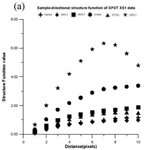
The singular structure function pattern are depicted in the Figure 2(a). As mentioned previously, these poor structure functions are mainly caused by satellite observation geometry and complex landcover distribution. These patterns would induce further errors in the optical depth estimation. When multi-directional structure function is employed as illustrated in Fig 2(b), the improvement is evident.
 |
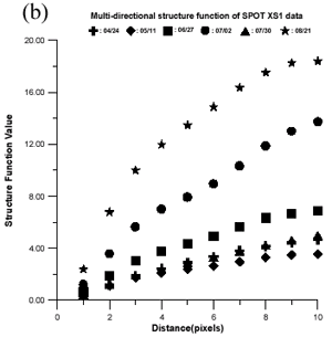 |
| Figure 2 (a) The variaties of the structure function with different distances of SPOT XS1 channel. (b) Same as (a), except for multi-directional structure function. | |
Further analysis showed that the some abnormal patterns still existed in our approach. Therefore, the “optimal number” decision was added to determine the proper distance value, d and made sure that the abnormal structure function patterns can be removed.
The final result is summarized in Table 3. Obviously, the accuracy of multi-directional method is better than the single-directional method, except on May 11 (party cloudy). The error is reduced from 33% to 9%. The result reveals improvement in accuracy derived from multi-directional method and the optimal number decision
Table 3. The comparison between the estimated optical depths estimated by the single & multi direction structure function methods. (* : reference date).
| Date | Sunphotometer measurements |
Single-directional | Multi-directional | ||
| Retrieved | Error(%) | retrieved | Error(%) | ||
| 1998/04/24 | 0.339 | 0.386 | 14 | 0.348 | 3 |
| 1998/05/11 | 0.647 | 0.394 | 39 | 0.374 | 43 |
| 1998/06/27 | 0.299 | 0.347 | 16 | 0.311 | 4 |
| 1998/07/02 | 0.209 | 0.277 | 33 | 0.228 | 9 |
| 1998/07/30 | 0.315 | 0.356 | 13 | 0.345 | 9 |
| 1998/08/21* | 0.078 | -- | -- | -- | -- |
Conclusions
The results strongly suggest that including multi-direction and optimal number in structure function method will greatly improve the accuracy of derived aerosol optical depth. In the further study, the relationship of test area sizes and distance values are necessary to be investigate in detail. In order to verify the accuracy of optical depth estimation, the accuracy and method of deriving optical depth from sunphotometer observation is also an important task.
Acknowledgements
This work has been supported by grant from the National Science Council, ROC under NSC86-2612-E-008-007.
References
- Fraser B. C., Y. J. Kaufman, and R. L. Mahoney, 1984: Satellite measurements of aerosol mass and transport. Atm. Environment, 18(12), 2577-2584.
- Griggs M., 1975: Measurements of atmospheric optical thickness over water using ERTS-1 data. Journal Air Pollution Control Association. 25, 622-626.
- Holben B. N., Y. J. Kaufman, A. Setzer, D. Tenre’, and D. E. Ward, 1990: Optical properties of aerosols from biomass burning in the tropics, BASE-A. Presented at the Chapman Conference on Biomass Burning. Williamsburg, VA, Mar., 1990.
- Holben B. N., E. Vermot, Y. J. Kaufman, D. Tanre, and V.Kalb, 1992: Aerosol retrieval over land from AVHRR data-application for atmospheric correction. IEEE Trans. on Geoscience and Remote Sensing, 30(2), pp. 212-222.
- Kaufman Y. J., R. S. Fraser, and R. A. Ferrare, 1990: Satellite measurements of large-scale air pollution methods. J. Geophys. Res., 95(D7), 9895-9909.
- Liu C. H, A. J. Chen, and G. R. Liu, 1996: An image-based retrieval algorithm of aerosol characteristics and surface reflectance for satellite images. INT. J. Remote Sensing, 17(17), 3477-3500.
- Liu G. R, T. H. Lin, and A. J. Chen, 1997: An improved method to determine aerosol optical depth from SPOT data. COAA ‘97-First International Ocean-Atmosphere Conference, 18-19 Oct 1997, Washington, D. C., USA.
- Mekler Y., H. Quenzel, G. Ohring, and I. Marcus, 1977: Relative atmospheric Aerosol content from ERTS observation. J. Geophys. Res., 82, 9867-972.
- Rao C. R. N., E. P. McClain, and C. C. Stowe, 1989: Remote sensing of aerosols over the oceans using AVHRR data theory. Practice and Applications, INT. J. Remote Sensing, 10( 4-5), 743-749.
- Sifakis N. I., N. A. Soulakellis, and D. K. Paronis, 1998: Quantitative mapping of air pollution density using earth observations: a new processing method and application to an urban area. INT. J. Remote Sensing, 19(17), 3289-3300.
- Tanre D., C. Devaux , M. Herman, R. Santer, and J. Y. Gac, 1988: Radiative properties of desert aerosols by optical ground-based measurements at solar wavelengths. J. Geophys Res., 93, pp 14223-14231.