| GISdevelopment.net ---> AARS ---> ACRS 1999 ---> Disasters |
GPS Observation of PW
Depletion after Typhoon
Yuei-An Liou, Cheng-Yuang
Huang, and Yu-Tun Teng
Center for Space and Remote sensing Research
And institute of Space Science
National Central University
Chung-Li, China Taipai
yueian@csrsr.ncu.edu.tw
Abstract
Center for Space and Remote sensing Research
And institute of Space Science
National Central University
Chung-Li, China Taipai
yueian@csrsr.ncu.edu.tw
GPS ( Global Positioning system ) is used to monitor depletion in perceptible water ( PW) after tropical cyclones in Taiwan. Typhoon Zeb that caused serious damages to the Philippines, Taiwan, and Japan in mid-October 1998 is chosen as an example. GPS data collected at Central Weather Bureau's ( CWB's) three weather stations of Taiwan and in Tsukuba of Japan are analyzed. Bernese version 4.0 software is utilized to solve GPS signals for total delay due to neutral atmosphere at the three CWB sites. Wet delay is obtained by subtracting total delay from surface pressure derived dry delay. It is then converted to PW through a simple calculation. GPS solutions demonstrate that PW is in general high before and during the occurrence of the typhoon, and low after the typhoon. They show that a PW increases from about 5 cm on DoY 285( October 13) to near 8 cm or so on DoY 288 ( October 16) when the typhoon was striking Taiwan, and, then decrease to 2-3 cm after typhoon. In addition, GPS-observed PW depletion by about 5 cm from 8 cm on DoY 288 to about 3 cm on DoY 290 is found to be consistent with radiosonde observations acquired at the Taipei weather station.
Introduction
Tropical cyclones are the most serious weather system that threaten Taiwan. Accurate prediction of their track, intensity, precipitation, and wind fields is extremely crucial to reduce their damages to agriculture, industry, and human life. Of the devastating tropical cyclones, typhoon Zeb that caused serious damages to Taiwan in Mid-October 1998 was a typical example. It took 39 lives, destroyed 30 buildings, and caused agricultural loss of $17 million dollars.
Since perceptible water ( PW) is essentially the source of precipitation, and a dominant constituent of the energy source to maintain the dynamics of he cyclones, knowledge of its spatial and temporal distribution can not be overestimated in the study of monitoring and predicting tropical cyclones. We have devoted ourselves in monitoring PW for years. We began with the monitoring of PW by radiometer ( Liou, 1999). This radiometric approach was than applied to constrain GPS for the sensing of PW ( Liou and Yang, 1999). Recently, the GPS sensing technique was advanced to estimate absolute total wet delay, that is then converted to PW( Liou and Teng, 1999; Liou et al., 1999). Liou et al. (1999) showed that the GPS sensing technique provides PW measurements better than 90% accuracy compared to radiometer observations . the feasibility of using GPS to measure PW has been also demonstrated by the other scientists in the literature ( Rocken et el. 1993; Bevis, 1994; Tregoning et al., 1998.)
In this paper, we apply the GPS sensing technique to monitor PW variation during the striking of tropical cyclones. The 1998 Typhoon Zeb is chosen as an example. The relationship between wet delay ( ZWD) and PW is presented in the following section. GPS observation of PW depletion after Typhoon Zeb is subsequently presented.
Zenith Wet Delay Perceptible Water.
Microwave signals transmitted by GPS satellites are delayed by the neutral atmosphere. The delay can be used to derive the wet delay to PW by substrating the hydrostatic delay from it. This wet component can be converted to PW through ( Bevis, et al., 1994).
PW= Õ x ZWD (1)
Where
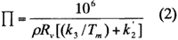
and p is the density of water , Rv is the specific gas constant of water vapor, J/kg-K, k2 is 22.1 ± 2.2, K/mb, K3 is (3.739 ± 0.012) x 105, K2/mb, and Tm is the weighted mean temperature of the atmospere, K,
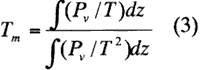
where Pv is the partial pressure of water vapor, mb, and T is the temperature of the atmosphere. K, In general, Õ is about 0.15. However, it is a function of season, location, and weather. Its amplitude may scatter over a range of 20% ( Bevis et al. 1994). We follow Liou et al. (1999) approach to compute Õ. Based on radiosonde collected at the Taipei site each October from the year 1988 to 1997, it was found that II ranges form 0.158 to 0.167, with an average value of 0.162 and a standard deviation of 0.0014. as expected, these statistics about Õ for October differ form those for March Presented by Liou et al. (1999).
GPS measurements are taken once per 30 seconds with the GPS receivers currently deployed in Taiwan, while there are no available data to provide such high frequency measurements of the atmospheric produce required for the estimate of Tm. Bevis et al. (1992) suggested that Tm can be approximated by the surface temperature Ts . similar to the approach for the finding for the Tm-Ts relationship for March ( Liou et al., 1999), the weighted mean temperature is approximated by surface temperature based on radiosonde soundings observed at the Taipei site each October from the year 1988 to 1997. then, the relationship between Tm and Ts can be determined by minimizing the Chi-square error statistic as
Tm= 0.9501 Ts + 206185. (4)
The root mean square ( rms ) deviation about this regression is 1.36K. the corresponding bias is -0.28 k. equation (4) differs from a similar relaiaonship for Bevis et al., ( 1992), Tm=0.72 Ts+70.2 with a corresponding rms deviation of 4.74 K, using radiosonde data obtained over a 2-years intervals from 13 stations in the United States. It is readily justified that eq. (4) is more appropriate to derive Tm from Ts for Taiwan area that the similar approximation proposed by Bevis et al. (1992).
Through eq .(2) and (4) , Ts can be used to compute Õ that can be subsequently used to derive PW from GPS-observed ZWD.. that is , PW can be determined after ZD is solved from GPS data. note that eq. (4) is applied to deriveTm from Ts for the other 2CWB stations because no radiosonde data are available at those sites.
We estimate hourly ZWD at the three CWB stations together with the baseline component from Tsukubna to the three CWB sites by using the Bernese GPS software version 4.0 developed by the University of Berne ( Beutler et al., 1996). L1 and L2 carrier phase observation observations are used in data reduction, and the precise GPS ephemeris is obtained from the international GPS service for Geodynamics ( IGS) . A satellite elevation cutoff angle of 12 degrees used in the data processing. The Tsukuba GPS station is chosen as reference because a minimum baseline of 1500 km or so is required to de-correlate atmospheric effects on the two ends of the baseline ( Liou and Tneg, 1999). All of the baselines between Tsukuba and the three CWB sites are longer than 2000 km. Note tahta the requirement for the minimum baseline is still arguable. Rocken et al., ( 1993) suggested that it should be at least 500 km. While Tregoning et al., ( 1998).
Observed PW Depletion after 1998 Typhoon Zeb
Figure 1 shows the surface measurements of (a) pressure and surface pressure estimated ZHD, and (b) precipitation collected at ahtye three sites of interest in Taiwan from DoY 285 ( October 13) to 292 ( October 20), 1998. the geographic locations of the three sites are form the southernmost sites of henc ( Hen-Chung ) to , a central Taiwan area of Chia ( Chia-Yi), and to the northernmost sites of banc ( Taipei ). From the pressure curves, it is evident that the center of he Typhoon Zeb was approaching the specific area between DoY 287 and 289 when the dips of the pressure curves occur. About the same period of time, heavy rainfall occurs at all sites due to the influence of the typhoon. Note that the dips are seen in the time sequence of Hen-Chung, Chia-Yi, and Taipei. This sequence is consistent with the northward path of the Typhoon Zeb while it was striking Taiwan.
Figure 2 shows GPS observed ZWD and the corresponding standard deviation while the ZWD solutions are sought, and radiosonde observations of ZWD at the Taipei site from October 13 to 20, 1998.it is an observable trend that ZWD starts to increase before the typhoon, reaches its maximum during typhoon's striking, reduces t a minimum right after striking, and finally recovers to tit nominal value a few days after striking. We notice that the quality of GPS solutions is bad for some periods of time. The solutions are defined as bad if ZWD standard deviation is relatively large. Hence, quality control ( OC) must be performed to assure good quality of ZWD solutions form PS. Note that it has been suggested that the accuracy of GPS observed PW possibly scales with total water burden ( Liou et al., 1999). Besides, the atmosphere could be extremely inhomogeneous when typhoon is closed by. We also observe that cycle slips seem to occur periodically from the standard deviation signatures, approximately within 2 hours after midday. The answer for this periodical slip shall be of great interesting to the literature, while we do not have it so far.
To acquire good quality in GPS estimates of ZWD, a threshold of 5 cm in the standard deviation is set when ZWD is determined. The resulting solutions of ZWD are then converted to PW. Figure 3 presents GPS observed PW at athe three CWB sites and radiosonde measurements of PW at the Taipei sites from October 13 to 20, 1998, there major characteristics can be seen. First, PW signatures show an expected trend that they mimic those of ZWD. Second, the sequence of PW depletion occurs from south to north. The time delay in PW depletion between the southernmost Hen-Chung location ot the northernmost Taipei site is about 8 hours, which is resulted form a time delay corresponding to the northward movement of the typhoon. Clearly, the PW depletion after Typhoon Zeb is captured by the PGS sensing technique. Third, GPS observed PW generally match radiosonde observations. Both readings increase from 5 cm on DoY 286 to 7-8 cm on DoY 288. then, they decrease to the minimum on DoY 290 although the minimums are 3.5 cm for radiosonde observations and observations and 2 cm for GPS measurements at the Taipei site. Finally, they return to their nominal values of 5 cm on DoY 292. We attribute this large discrepancy between two measurements near the dip at the Taipei site partly to the ihomogeneity of the atmosphere. Note that it is a general proactive to assume a stratified atmosphere to solve GPS data for ZWD. Apparently, this assumption should be carefully handled when the typhoon is nearby .
Conclusions
GPS is used to monitor PW dynamics in Taiwan due to the influence of Typhoon Zeb in mid-October 1998. GPS solutions demonstrate that PW is in general high before and during the occurrence of the typhoon, becomes low right after the typhoon, and finally recovers to its nominal values of few days latter. They show that PW increases from about 5 cm on DoY 285 ( October 16) when the typhoon was striking Taiwan, and , then decreases to 2-3 cm after. These signatures match those observed by radiosonde sounding. In addition, GPS-observed PW depletion by about 5cm from 8 cm on DoY 288 to about 3 cm on DoY 290 is found to be consistent with radiosonde observations acquired at the Taipei weather station . clearly, the depletion in PW right after typhoon is accurately captured by GPS.
Acknowledgments:
The authors appreciate much the National Space Program Office grant NSC 87-NSPO (A)-PC-FA07-05. they also thank CWB for providing GPS data.
Reference:
- Bevis, M., S. Businger, T.A. Herirng, C. Rockmen, R.A. Anthes, and R.H. Ware, 1992: GPS meteorology: Remote sensing of atmospheric water vapor using the global positioning system .j. Geophys. Res., 97, 15, 784-15,801.
- Bevis, M., S. Businger, S. Chiswell , T.A. Herirng, R.A. Anthes , C. Rockmen, and R.H. Ware,, 1994: GPS meteorology : Mapping zenith wet delays onto perceptible water. J. Appl. Meteoro., 33, 379-386.
- Liou, Y.-A., 1999b: Ground-based radiometric sensing af atmospheric dynamics in perceptible water vapor. Atmospheric Sciences, 27, 141-158.
- Liou, Y.-A.,and M. Yang, 1999: precipitable water from GPS : A WVR constraint approach. Atmospheric Sciences , 27, 131-140.
- Liou, Y.-A.,and Y.-T. Teng , 1999: :Comparison of perceptible water observations in the tropics by GPS, radiometer, and radiosondes, J. Appl. Meteoro. ( revised ) .
- Liou, Y.-A., and Cheng-Yung, and Y.-T. Teng 1999: Precipitable water observed by ground -based GPS receivers. Earth, Planets, and Spaces . ( Submitted)
- Rockman, C.,R. Warne, T. Van Hove, F. Solheim, C. Alber, J. Hohnson, M.Bevis, and S. Businger, 1993: Sensing atmosperic water vapor with the Global Positioning system, Geophys. Res. Lett., 20, 2,631-2,634.
- Tregoning, P., R. Boers, D.O' Brien, and M. Hendy, 1998: Accuracy of absolute precipitable water estimates from GPS observations. J. Geophys. Res., 103, 28,701-28,710.