| GISdevelopment.net ---> AARS ---> ACRS 1999 ---> Agriculture/Soil |
GIS-Based Regional Spatial
Crop Yield Modeling
Satya Priya* and Ryosuke
SHIBASAKI**
*Post Doctoral Fellow, **Professor
Center for Spatial Information Science
University of Tokyo, 4-6-1 Komaba
Meguro-ku, Tokyo 153-8505, JAPAN
Fax: +81-3-5452-6414
Email: mailto:satya@skl.iis.u-tokyo.ac.jp ,satya@tokyo.ac.jp
Keywords: Agriculture Productivity, GIS,
Spatial Modeling *Post Doctoral Fellow, **Professor
Center for Spatial Information Science
University of Tokyo, 4-6-1 Komaba
Meguro-ku, Tokyo 153-8505, JAPAN
Fax: +81-3-5452-6414
Email: mailto:satya@skl.iis.u-tokyo.ac.jp ,satya@tokyo.ac.jp
Abstract
Traditional decision support systems based on crop simulation models are normally site-specific. In order to address the effect of spatial variability of soil conditions, topography and weather variables on crop production, a Geographic Information Systems (GIS) was linked with crop simulation models. This system was used to predict spatial yield variability of wheat, rice and maize crop on regional level as a function of spatial soil water conditions under various weather regimes. The model "Spatial-EPIC" (Satya et.al., 1998) has been developed to understand the interaction between crops and the environment to accomplish the task. As example, India was used for model application and validation viewpoint, because of the fact that the country owes the most diversified agroecosystem. Results showed that the crop yield of maize, wheat and rice crop varied significantly as a function of seasonal climatic variation, favorable crop growing region, soil water holding characteristics and selected crop management strategies (e.g., the temporal increase of fertilizer application, irrigation applied and so on.)
Introduction
Agricultural system are overwhelmingly a complex process of air, water, soil, plants, animals, micro-organism and everything else in a bounded area that people have modified for the purposes of agricultural production. An agroecosystem can be of any specific size. It can be a single field, household farm or it can be the agricultural landscape of a village, region or nation. Some of the most important decision in agricultural production, such as what crops to grow and on how much land to allocate depends on the existing knowledge base of current and future physical conditions like soil and climate, yields and prices. Modeling of the various processes in the system helps us to understand its flow and intricacies. An important issue in agricultural environmental modeling is that all the basic units (water, soil and chemicals) have a spatial distribution, and since this distribution does affect the processes and dynamics of their interaction considerably, geographic information system (GIS) is emerging as an important tool in modeling.
Till date, there have been a lot of studies on agricultural potential productivity. To relate actual crop productivity, however, only model-based simulations are not sufficient. Biophysical spatial based model is still lacking to compute agricultural productivity at regional or national level although the estimates of farm productivity are being done using experimental/plot based model. Site-specific management, or precision farming, is a strategy in which cropping inputs such as fertilizer are applied at varying rate across a field in response to variations in crop needs.
Modeling within a GIS offers a mechanism to integrate the many scales of data developed in and for agricultural research. Irrespective of the scale at which various crops, agriculture environment models operate, it is known that management practices geared towards conservation and productivity are initiated at the field level. At present, however, few agricultural producers are utilizing the true analytical power of GIS and computer simulation models, partly because the loose or no linkages developed to-date between GIS and mostly public-domain modeling software are extremely cumbersome to use or are esoteric. Thus a need exists for an integrated, GIS modeling system to allow agricultural producers as well as policy makers to know the impact of differences between input and output spatially from one place/region to other from better management, productivity and profitability viewpoint.
The objective of this study was to expand the use of crop simulation models through a linkage with GIS and spatial physical databases. Also it was aimed to apply the computer system and to study distribution of yield as a function of applied physical and management practices of spatial variability on a regional level.
Material and Methods
Model Selection
Proper model selection is the most important step in any modeling exercise. As a evident, a plethora of environmental models exist, each with unique characteristics and capabilities. In addition to this, optimistic claims by model developers, and conflicting modeling objectives, all create a dilemma for the model user in selecting model for a particular objective.
Therefore, based on the literature reviewed and expert opinion gathered from model developers, EPIC (Williams, J. R. and Sharpley, A.N.,1989) was selected for further development under the defined framework of this study. Some additional model features that favored the selection of EPIC are (Dumesnil 1993):
- EPIC is a continuous, field scale agricultural management/water quality model.
- The EPIC model is broad-based in terms of its components to model major biophysical processes which include weather, hydrology, erosion, nutrients (nitrogen and phosphorus) cycling, pesticide fate, soil temperature, crop growth, tillage, plant environmental controls and economics.
- The data required by EPIC are minimal and was made available after deriving the concept of generators.
- The model provides parameter data files for major crops, soils, and tillage practices.
- EPIC is also equipped with a stochastic weather generator.
- EPIC is capable of simulating the long-term effects of cropping systems on soil erosion and productivity in specific environments.
To understand what these crops needs are from point to point/pixel to pixel, it is necessary to understand the relationship between crop yield and both controllable (such as fertilizer nutrients) and uncontrollable (such as soil, topography) factors. The effect of these factors on yield is complex and may change from point to point within a field. Recently, one of the many challenges facing regional, national or global agricultural research is the simple understanding of potential solutions to the constrains for achieving its solutions. Identification of opportunities and constraints is the task of characterization. Modeling within a GIS offers a mechanism to integrate the many scales of data developed in and for agricultural research. Data access, including modeling results, expands to a "decision system" or decision tool which uses a mix of process models (where appropriate/possible) and biophysical data (growing season climate characteristics, soils, terrain). An accurate spatial (and temporal) database enables the characterization of agricultural systems. This ability is vital in the developing world for efficient resource allocation in agricultural research. Agroecosystems are complex entities, which span several levels or scales, with different processes dominating each scale. Therefore, a dynamic agricultural system characterization requires biophysical characterization integrity to be maintained by addressing particular objectives with specific information – information which may aggregate up - or down - scale (e.g. the aggregate description of a complex of soils would deliver a sensible "regional" characterization). With spatially interpolated climate data, digital elevation models, and low resolution soils data in place, agroecosystem characterization commences with simple models used to differentiate growing season and off season characteristics. These "climate analog" models here used as a “Weather Generator” serve to describe the initial domain or target area for a range of priority setting. Other information - usually much more difficult to acquire - becomes critical in refining target domains as resource access, land tenure, cropping system, labor availability etc. dominate the land use system at higher resolutions.
Therefore, GIS based modeling of an agroecosystem is expected to give a new approach in order to provide agricultural managers with a powerful tool to assess simultaneously the effect of farm practices to crop production in addition to soil and water resources. As we saw in above model selection section, at present, most of the crop models are location specific (point based) in nature, but to understand the impacts on the agricultural systems, it is necessary to have spatially explicit information. Therefore, development of spatially or raster based biophysical crop model took long way in helping us to understand many intricacies of modeling of large areas at coarse and fine resolution. To do this, Spatial Erosion Productivity Impact Calculator, [Spatial-EPIC] (Satya et.al.,1998) was developed which gave us a new direction to simulate crop production at regional scale from microscopic simulation at each small piece of land in an efficient way, enables us to incorporate the environmental issues. “Spatial-EPIC” is a crop simulation model developed to estimate the relationship between soil erosion and crop productivity which has been implemented in GIS environment at 50km and 10 km grid size for a nation and region respectively to have spatial distribution of crop output then the classical point based method.
Biophysical Computation
The model is composed of physically based components for simulating plant growth, nutrient, erosion, and related process for assessing crop productivity, determining optimal management strategies, erosion and so on. Simultaneously and realistically, model simulates the physical processes involved using readily available inputs. Commonly used input data are weather, crop, tillage, soil-attributes and management parameters. The model runs on defined rather derived cell size data layers provided by the user depending on their availability. All physical processes and plant management are being computed using mathematical model to find the effects of crop productivity coming from different processes and how all these different processes affects overall crop productivity. "Spatial-EPIC" is composed of physically based submodels for simulating weather, hydrology, erosion, plant nutrients, plant growth, soil tillage and management, and plant environment control. The model runs on daily time-step therefore, each model is linked subsequently and interactively with other sub models as explained below. In brief, the each sub module are dealt with their computation procedure. Weather: daily rain, maximum and minimum temperature, solar radiation, wind and relative humidity can be based on measured and data and/or generated stochastically. Hydrology: runoff, percolation, lateral subsurface flow are simulated. Erosion: it simulates soil erosion by wind and. Nutrient Cycling: the model simulates, nitrogen and phosphorus fertilization, transformations, crop uptake and nutrient movement water (for this paper the erosion part has and nutrient cycling not been included). Nutrient can be applied as mineral fertilizers, in irrigation water, or as animal manures. Soil: soil temperature responds to weather, soil water content and bulk density. It is computed daily in each soil layer. Tillage: the equipment used affects soil hydrology and nutrient cycling. The user can change the characteristics of simulated tillage equipment, if needed. Crop Growth: A single crop model capable of simulating major agronomic crops. Crop-specific parameters are available for most crops. The model also simulates crop grown in complete rotations. Plant Environment: It is capable of variety of cropping variables, management practices, and other naturally occurring processes. These include different crop characteristics, plant population, dates of planting and harvest, fertilization, irrigation, tillage and many more those are normally practiced in the field.
Study Area and Databases
The chosen study area is India, lies to the north of equator, between 8° 4’ and 37° 6’ North and 68° 7’ and 97° 25’ East. It is bounded in the south by the Indian Ocean, in the west by the Arabian Sea, in the east by Bay of Bengal, in the north-east, north and a part of the north-west by Himalayan ranges, and the rest of the north-west by the Great Indian Desert. The soil characteristics of Indian nation were obtained after digitization of survey of India soil map with many properties like soil texture, soil pH and soil depth. Slope information of the country was derived from GTOPO30 (NGDC, 1997). Weather data were obtained and their surfaces were generated using World Meteorological Organization station falling around 230 in number scattered throughout India. Agricultural management data were obtained at state level where there numbers are more than 30 in total of entire India at 5 year interval which was used for coarse level whole country simulation of 50 km cell size. On the other hand we succeed in procuring time-series data from 1974-1994 for one of the Indian State Bihar for detailed study at finer resolution simulation of 10-km cell size.
Results and Discussion
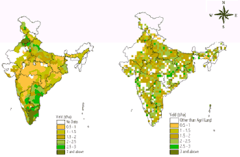
The model developed described in the earlier part of paper was found capable for simulating an unlimited number of crop management strategies, based on the selection and data provided by the user. In contrast to a stand-alone original EPIC crop simulation model, where the management information given in the beginning continues for the total no. of simulations year, the trend of output used to be more or less static and doesn't correspond to the actual farm practice. With the development of dynamic loop under "Spatial-EPIC" it got rectified. Now with this, during computation the model runs for each and every pixel following the rows and columns sequence with various multiple soil, climate, and management information provided in the form of layers. Two-year crop rotation was found appropriate for long term simulation. The crops selected in a row were maize-wheat-rice. Crop management options provided by user are applied to run the model. Besides these there are many other information which need to be fed like start of simulation date, planting date, harvesting date, tillage time, irrigation timing its amount, fertilization time and so on. Amount of fertilizer applied used was the reported state and district level time-series data procured during the study. The crop selected in sequence for modeling was rainfed maize (without irrigation), irrigated wheat and monsoon rice with one user specified assured irrigation. All possible measures explained above were taken into account to mimic the more realistic field practice. Yield simulation of the rainfed maize varied from 0.4 to 3.5 t/ha as described validation. Yield distribution of irrigated wheat crop varied between 0.5 to 3.5 t/ha also shown in figure described below under validation section clears that only the northern part of India is the wheat belt. Because of the fact that the Indo-Gangetic plains form the most important wheat area. The cool winters and the hot summers are very conducive to a good crop of wheat, whereas the rice is being grown throughout India and the southern part was found more favorable from agro-climatic conditions. Similarly yield variation of monsoon rice was found to be fluctuating from 0. 3 to 3.0 t/ha. . As a reference and to serve a clear understanding rather image of major and minor growing areas of these three crops in India with their planting and harvesting calendar, the maps will be shown during the presentation of the paper in conference. The distribution of crop productivity output is shown in figure as detailed in validation section with its spatial validation to show their correspondence.
Validation
The first approach used to evaluate "Spatial-EPIC" yield simulation was to compare the output at state level average reported data values. Closeness between measured and predicted yield at state level is first and coarse level validation to see whether the simulated output is following the trend is of reported aggregate average. For doing this the simulated 0.5 degree pixel resolution falling under the state were averaged and their mean were compared with the reported state level average for wheat and rice crop respectively. Also, all the pixels following under particular district were averaged and their computed means were compared with the average reported statistical district value for these three crops. To see the same output spatially distributed over the country (as a spatial rough validation) where the main growing zone of these crops can also be identified could be seen in figure 1 to 3 as validation process. Simulated vs. reported yield of maize, wheat and rice as a rough cum spatial validation is rather important to have more explicit understanding of the area and their correspondence between productivity. Although there were some places where model has simulated high or low yields in case of maize and rice but in general it gives a very nice comparison hence one can easily identify the model performance by seeing these three maps as shown in the above said figure. Other validation results will be shown during the presentation in terms of several regression analyses and their r squared values.
Figure 1. Rough Spatial Validation of Maize Crop in 1990-91

Figure 2. Rough Spatial Validation of Wheat Crop in 1990-91
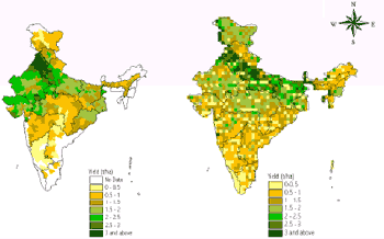
Figure 3. Rough Spatial Validation of Rice Crop in 1990-91
Conclusions
The methodology presented found to be encouraging that provides an opportunity to plant physiologist, a modeler and GIS user a common ground to discuss simulation results and further potential research directions. Simulated crop yield and other maps generated under different scale dependencies within India can be used to better communicate model predictions. Hence, using this methodology a region/nation can be modeled for any crop productivity, which help researchers and decision-makers understand the status and extent of climate, soils and crop cum field management effects on global processes such as rice, wheat and maize production.
Acknowledgements
This research is funded by "Research for the future" (in Japanese, Mirai Kaitaku ) under the program of Japan Society for Promotion of Science.
References
- Williams, J. R. and . Sharpley, A.N., (eds.), (1989). EPIC --Erosion/Productivity Impact Calculator: 1. Model Documentation, USDA Technical Bulletin No. 1768.
- Dumesnil, D., ed. 1993. EPIC user’s guide-draft. USDA-ARS, Grassland, Soil and Water Research Laboratory, Temple, TX.
- Satya Priya, Shibasaki, Ryosuke and Shiro Ochi (1998) Modeling Spatial Crop Production: A GIS approach, Proceedings of the 19th Asian Conference on Remote Sensing, 16-20 Nov., 1998 held at Manila. pp A-9-1 to A-9-6.
- NGDC, 1997. GTOPO30, Global Land One-Km Base Elevation, (Average 30-Second Elevations Grids). National Geophysical Data Center 325 Broadway, Boulder, Colorado.