| GISdevelopment.net ---> AARS ---> ACRS 1998 ---> Poster Session 3 |
Determination of Land Use
Change Categories Using Classification of Multitemporal Satellite Image
Data
Kyu-sung Lee and Mi-Reyoung
Joung
Inha University, Dept. of Geoinformatic Engineering
253 Yonghyun-dong, Nam-ku, Inchon, 402-751, Korea
E-mail : ksung@munhak.inha.ac.kr
AbstractInha University, Dept. of Geoinformatic Engineering
253 Yonghyun-dong, Nam-ku, Inchon, 402-751, Korea
E-mail : ksung@munhak.inha.ac.kr
This study attempts to determine major land cover change categories using satellite remote sensing data collected at three different times. The study area covers approximately 10,000 km2 of the provinces of Pyungan and Hwanghea in western region of North Korea. Using multitemporal Landsat imagery obtained from 1973 to 1993, land cover types for each year were classified. Primary land cover change categories, such as the conversion of forest land into cropland, were defined based on the classification accuracy of each data set and the temporal pattern of land cover classes observed on three classified maps.
Introduction
Land cover/use change detection has been a major application field of remote sensing ever the first earth observing satellite was launched. Since remote sensor data from the earth orbit can be obtained repeatedly over the same area, they have been very useful to monitor and analyze land cover changes in various regions of the earth. Several algorithms of digital change detection have been developed and each method has own characteristics of data analysis and the extent of information to be extracted (Jensen, 1996; Singh, 1989). Most change detection methods are based on the data sets collected at two different times. Although there are plenty of multitemporal image data over the same area, it is surprising that most change detection studies have been primarily conducted using only the data sets obtained at two times. The time lapse between two data sets depends on the change characteristic of interest. Seasonal and annual changes of vegetation cover have been frequently analyzed by using vegetation indices that were derived from multitemporal dta sets collected at more than two times (Eastman and Fulk, 1993; Lambin and Ehrlich, 1997; Washington-Allen et al., 1998). Certain change detection methods, such as band ratioing and differencing, are primarily based on the data sets that had a constant environmental characteristics of atmospheric conditions and vegetation phenoloyg.
Since it is difficult to maintain such constant environmental conditions among the multitemporal data sets to be analyzed, post-classification comparison method is often used for analyzing land cover/use changes. Post-classification comparison method treats each data set separately and only compares the classification result obtained from each data set (Miller et al., 1998). However, this method assumes that the classification results are completely correct, which is not true in real situations. This study attempts to develop a methodology to define the land cover change categories from the classification results of multitemporal data collected at three different times.
Methods
Study Area and Data Used
In recent years, the extreme case of food shortage in North Korea became a great concern to international community. Even though it has been expected that rather large scale land development practices were continued to increase the crop cultivation lands during the last few decades, there is a lack of reliable information related to the land cover/use statistics in North Korea. This study was designed to access the land cover changes occurred during the last two decades by using satellite remote sensor data.
The study area cover approximately 10,000 km2 of the Pyungan and Hwanghea provinces in western part of North Korea. Although this area covers less than 10% of the country's territory, about an half of total population reside in this region. Considering the relatively dense population and gradual topography, it is expected that the study area has been under more intensive land management practices than the other parts of the country.
Three scenes of Landsat Multispectral Scanner (MSS) and Thematic Mapper (TM) data obtained in 1973, 1984, and 1994 were used to classify and analyze the land cover changes. For the change detection purpose, it is desirable to use satellite imagery types due to the variation of vegetation growth. However, the multitemporal data sets obtained at the same growing season were not usually available in particular during the summer months from June to September because of the persistent cloud cover during the growing season in Korean Peninsula.
Coregistration
Three sets of Landsat data contain different level of radiometric and geometric distortions. The 1973 MSS data showed the stripping effect that was often found in early Landsat imagery. After the correction of stripping effect, the three data sets were then rectified and registered into a plane rectangular coordinate system. Geometric rectification of the data sets based was on asset of ground control point (GCP) that could be identified on both map nad imagery. During the resampling procedure the spatial resolution of TM data was degraded as to match the one of MSS data and to reduce the total volume for the proceeding analysis.
Classification
Each of there data sets was classified separately to overcome the discrepancy of spectral variation by the data acquisition time. Since the vegetation condition at three different times (April, October, and May) might be different, it was difficult to apply an identical classification scheme to all there data sets. Each data sets was classified using an unsupervised clustering algorithm. Because there were lack of reference data to be used for delineating training fields, it was difficult to apply supervised classification procedure. By careful examination of the spectral and spatial pattern of each cluster, every cluster was assigned into on of six land cover classes (water, forest, rice, field, non-irrigated crop, urban and bare soil). The accuracy of each classified map was separately determine by using test pixels that were carefully selected throughout the study area and evenly distributed for each of six cover types. For each data set, about 1,700 test pixels were used to determine the classification accuracy.
Determination of change categories
After the classification of there data sets, each pixel unit has three lands cover class values for the year of 1973,1984 and 1993. Combing these three classified land cover maps, the temporal variation of change and no-change of land cover could be described. Each pixel can have 216 possible combinations of change and no-change categories. There would be no change where the class values in all three maps were identical. Except those six cases where the class value were the same, all other combinations of three class values represent land cover changes from 1973 to 1993. However, such assumption is only valid for the case where the classification of each data set is entirely correct, which is certainly impossible in real situations.
Determination of meaningful change categories was conducted by the evaluating the three time-sequential cover types and classification accuracy (figure1). Every classified pixel has accuracy for a particular cover type at one three years. Since the classification accuracy of 1973 is statistically independent from the ones of 1984 and 1994, the product of all three accuracies can b considered as accuracy of the change category Cijk.
P(Cijk)=P(C1iÇC2iÇC3k) = P(C1i). P(C2j). P(C3k),
Where Cijk is a change category where the cover type was I, j, and k for the years of 1973, 1994, and 193, respectively. The change category Cijk would be considered and re-examined by visual analysis if P(Cijk ) value was too low.
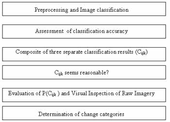
Figure 1. Data analysis procedure to determine change categories.
Some of the change categories, such as 'rice -forest-crop' in three years, are undoubtedly unreasonable in ordinary land use practice. Once each one of 216 change and no-change categories was carefully analyzed by using the classification accuracy and the visual interpretation on image display, primary change categories were determined. Major change categories include the conversions of forest to agriculture, bare soil, and urban, the conversion of agriculture to bare soil and urban, the reclamation of tidal flat to cropland, and the inundation by newly built reservoir.
Result and Discussions
Accuracy assessment of three temporal data shows that most cover types were classified with acceptable level of accuracies (Table 1). The low classification accuracies found in urban class may be due to the spectral characteristics that are very similar to bare soil class. In three years, the forest land occupy about 40% of the study area and it has been continuously declined. The area of cropland and urban was proportionally increased. Since the data acquisition time of MSS and TM data used for this study was rather inappropriate for showing the green canopy, it might be difficult to correctly classify certain types of non-irrigated crops. Therefore, the bare soil class, which seems to be over estimated, may be a mixing class between pre-planted (or harvested) cropland and abandoned barren land. Although rice fields show the same seasonal pattern of leaf development, it could be easily classified by using the unique spectral characteristics from the water-covered group conditions and relatively dark soil.
|
year type |
1973 | 1984 | 1993 |
| Water | 0.919 | 1.000 | 1.000 |
| Forest | 0.996 | 0.991 | 1.000 |
| Urban | 0.458 | 0.566 | 0.693 |
| Rice | 0.890 | 0.937 | 0.983 |
| Crop | 0.520 | 0.904 | 0.700 |
| Soil | 0.993 | 0.970 | 0.998 |
| Overall | 0.831 | 0.906 | 0.901 |
Table 2 shows the definition and the areal extent of determined major change categories. Since we used three temporal data sets, there could be a few change categories that were used by three different cover types, such as forest in 1973, cropland in 1984, and urban in 1993. However, such categories account for very small portion of area and wee entitled into major change categories (i.e., forest-crop-soil is entitled as forest-soil category). Over the twenty years period, 18.4% (175,800ha) of the area have been undergone certain types of land cover changes. About 102,311 ha of forest lands have been converted to rather intensive land uses, such as agriculture and urban. Because of the persistent food shortage, it should be inevitable to find new lands to increase agricultural production. However, it was questionable whether the shifting of land uses was appropriate to sustain the environmental conditions of the land. Although large portion of bare baresoil area can be considered as non-irrigated crop land converted baresoil area may represent barren lands that were no longer capable to be used for food production.
| Land cover change category (1973-1993) | Area (ha) | % | ||
| Category | Form | To | ||
| A | Forest | Agriculture | 71,997.8 | 7.5 |
| B | bare soil | 14,136.1 | 1.5 | |
| C | urban | 16,178.7 | 1.7 | |
| D | Agriculture | bare soil | 27,877.1 | 2.9 |
| E | Urban | 31,489.9 | 3.3 | |
| F | Water | rice field (polder) | 6,049.9 | 0.6 |
| G | Land | Water (reservoir, lake) | 4,864.1 | 0.5 |
| H | Miscellaneous | 3,173.3 | 0.3 | |
| I | No-change | 779,439.0 | 81.6 | |
| Total | 955,205.9 | 100 | ||
Conclusions
Post-classification change detection is mainly used for the case where the classification of individual data set is almost correct. However, land cover classification may not be entirely correctly for the area where are great variation in vegetation phenology. In such cases, we have to cautious to determine the final change categories. Considering that classified cover type in each data set has inherent classification error, combining the classification results of more than two data sets should enlarge the mirespresentation of change characteristics . In this study, the change categories were determined by considering both classification accuracy and visual interpretation. Even though it was difficult to assess the final results of change analysis without field verified ground truth, we believed that the proposed method can provide more reliable information related to the land cover changes.
North Korea has shown a continuing effort to increase agricultural lands to solve the problem of food shortage during the last decades. The consequences and status of such land management, however, are not well clarified. Multitemporal satellite imageries were processed for the year of 1973, 1984, and 1993 to analyze the characteristics of land cover changes. Major land cover change categories identified was the conversion of forest of forest lands to agricultural uses, which comprises 58% of total changes occurred from 1973 to 1993. Overexploited forest lands should have great impacts to increase soil erosion and, consequently to degrade the capability of agricultural production of the land.
Reference
- Eastman, J.R. and M. Fulk, 1993. Long sequence time series evaluation using standardized principal compoents, Photo. Enger. And Remote Sensing, 59(6):991-996.
- Jensen, J.R., 1996, Introduction digital image processing, Prentice Hall.
- Lambin, E.F. and D. Ehrlich, 1997. Land-cover changes in sub-Saharan Africa (1982-1991): Application of a change index based on remotely sensed surface temperature and vegetation indices at continental scale. Remote Sensing of Environment, 61-:181-200.
- Miller, A.B., E.S. Bryant, and R.W. Birnie, 1998. An analysis of land cover changes in the Northern. Forest of New-England using multitemporal Landsat MSS data, Int. J. Remote Sensing, 19(2):245-265.
- Singh, A., 1989, Digital change detection techniques using remotely-sensed data, Int. J. Remote Sensing, 10(6):989-1003.
- Washington-Allen, R.A., R.D. Ramsey, B.E. Norton, and N.E. West 1998. Change detection of the effect of severe drought on subsistence agropastoral communities on the Boivian Altiplano, J. Remote Sensing, 19(7):13190-1333.