| GISdevelopment.net ---> AARS ---> ACRS 1998 ---> Poster Session 3 |
Chinese Statistical Data
Analysis and Mapping Software and Its Application
Zhou Yi Tian Qing Xiao
Chunsheng Yan Shouyong Wang Shixin
Institute of Remote Sensing Application Chinese Academy of Science
P.O. Box 9718, Beijing 100101, China
Chung-li, Taiwan
Tel: (0086)-10-648794460 Fax : (0086)-10-64889786
Email: duer@public.east.cn.net
AbstractInstitute of Remote Sensing Application Chinese Academy of Science
P.O. Box 9718, Beijing 100101, China
Chung-li, Taiwan
Tel: (0086)-10-648794460 Fax : (0086)-10-64889786
Email: duer@public.east.cn.net
Chinese statistical data analysis and mapping software has been develop in the GIS Division, Instituted of Remote Sensing Application , Chinese Academy of Sciences (IRSA/CAS.(1) the package has a number of functions such as data preparation, information query, thematic analysis and statistical mapping. Most recently , the boundary; map files of China at province and county levels were created in CSDAMA. The package can be used in tow ways : directly analyzing statistic data and building specialized application system. Until now we have conducted the following research with this package : 1) Compiling the Agricultural Atlas of China ,20 Studying Maternal and Children Health Situation in China, 3) Making divisions for crop yield estimating by remote sensing in China. In this paper, the software package is fires tintor4duced with emphasis on its environments , functions and characteristics . the applications of CSDMS are also reported.
Software system
CSDAMS is a GIS software mainly dealing with statistical data. It is designed for PCs pr9grammed by Visual C++ and runs on environment of Microsoft Windows. It consists of some sub-system s such as data preparation, information query, thematic analysis, statistical mapping.
Main Function
In order to meet the requirement of statistical data a, the system is designed to 5 functions. All the functions of CSDMS are described below.
- Data Preparation
Before entering in to the sub-systems of information query, thematic analysis , and statistical mapping, it is a must to ensure all data files linking , error correction and data summing-up.
- Information Query
Original statistical data and Information queried for management and decision making can be sought through logical conditions , data range grading and polygon selection in a map. It is frequently used for obtaining necessary information on general situation of an indicator in time and space.
- Thematic Analysis
- indicator Analysis. Analyses can be done to dingle indicator . through calculating of statistical parameter s, sorting of the administrative or mapping units and drawing of the histogram, indicator analysis can be help users understand the general distribution and character of an indicator qunantitavietly.
- Units Evaluation .There are tow different evaluation methods to be selected according to how many units are going to be assessed . one is relative positioning method, the other is multi-indicator sorting method.
- Forecasting Changes . First , the indicator to be forecast and its main concerning factors s independent variables are selected . second, the relationship between the indicator and the factors is established by stepwise regression method . finally, its value is calculated through the relationship or the model as mentioned above.
- Statistical Mapping
the symbol mapping is included in the sub-system of statistical mapping only. The different kinds of symbol maps such as the maps with bars or pies can be made at requirements of users.
- CSDAMS is centered on statistical data analysis and mapping. It is powerful mapping and analyzing tool , which can provide timely and large number of intuitive maps and tables.
- Besides the basic function of a general GIS software , many analysis models were appended to CSDAMS to enhance the analysis ability of the system . the result of analysis can be represented directly on the map.
- CSDAMS is composed of many nodules . to a certain extent , each module stands by itself . based on the structure, it can be used to build specialized application system . also , the system can be easily expanded if necessary.
- As a general software package, CDAMS cam be applied in all areas of national economic analysis: agriculture , urban planning, industry etc. and provide scientific decision making tool for economic development in China.
- This system has a very friendly user interface.
As CSDAMS is a general software package with may analysis models , it can be used, in every area of management to analyze statistic data and provid4e a scientific tool for the government in planning , management and decision making in their every day work . several pilot studies have been made with it.
- Compiling the Agricultural Atlas of China
The atlas is designed for agricultural managers and decision-makers to extract useful information form statistical data easily and quickly. The map set was finished with CSDAMS in 20 days. The atlas consists of 47 statistical thematic maps on agriculture status at county level in China and 47 relevant statistical tables . they can be divided in to 5 map groups according though their contents : general survey maps, grain-crop maps, cotton-crop maps, oil-crop maps, meat maps . all the maps can be classified into the following categories based on the representing method.- Distribution Maps
There are total 26 distribution -map in the atlas, which are used most frequently for describing the agriculture development in China. An indicator of a statistical map is graded according to its histogram in interactive way. On the color range -grading , map the distribution regularities in space as well as regional differences of the indicator are represented clearly and visually. Therefore, the distribution maps are very helpful to managers and decision -makers in government agencies.
- Varying Maps
there are 12 varying maps in the atlas , on which changes occurred in different period are reflected . the differentials are graded and represented in colors. This king of maps can not only help decision makers understand the impacts of certain policies and measured better, but also make it possible for them to identify the inherent reasons , and then to make more reasonable and practical policies .
- Sequence Maps
There are 4 sequence maps in the atlas. The total output at county level is chosen to be a sorting indicator . All units are arranged in descending order of total production . Then a graded sequence map is made and each grade carries a different color in the map. In the meantime, the cumulated amount of output of each grade and its percentage in the total output of the country are calculated and then the percentages are listed in the row of "Total". As a result, evaluation and analyses at county and province levels can be done separately , and selection of target areas for work or investment can be carried out more successfully.
- Supply-Demand-Gap-Maps
There is only map of kind in the atlas . this map covers the difference between supply and demand of grain at county level. Following the procedures mentioned above , the difference is calculated and graded by applying CAS/GIS, so that the factual information of supply and demand at province and county levels can be understood clearly and grain allocation among the provinces or region can be made much more reasonably and effectively.
- Classification Maps
There are 4 classified maps in the atlas. Based on changes of total production, sown area and of crops between 1985 and 1994, all mapping units with-indicators are classified using a cluster algorithm . the results are shown in a color classification map . the units in the same class or with the same class or with the same color are much more similar, the units with different colors are quite different . Therefore, the maps are very helpful to managers and decision -makers in government agencies in making flexible and effective decisions based on different conditions in different localities.
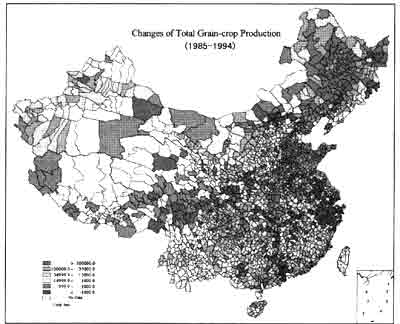
Fig. 1 is one of the maps from Atlas
- Distribution Maps
- Studying Maternal and Children Health Situation in China
The application of CSDAMS in maternal and children health management in China has offered an advanced, effective technical means of realizing the sustainable development of the enterpriser of maternal and children health. Since 1994, the maternal and children health information management departments of 30 provinces in China have been applying this software in their work. A national wide, multi-level network has been created . By using this software the quality of statistic data has been significantly improved, and the time for reporting these statistic data has also been saved. The maternal and children health work in China has been promoted to a new era.- with CSDAMS, some statistical maps on national maternal and children health situations have been compiled and evaluation s of some specific project have been made. These maps have vividly illustrated the development and achievement in maternal and children health management work in China. The main problems of our work also reflected and the emphases of the future work were indicated.
- When selecting the counties for some international cooperation projects , CSDAMS has been use dot generate different schemes and compare these schemes . this has increased the transparency and rationality in selecting Therese counties as the reasons and results of selecting have been easily seen in the maps and tables . the working circle and force have also been reduced.
- Through analyzing the statistic data at both county level and province level with CSDAMS, Health Department f China has enhanced the supervision to maternal and children health situation , strengthened the feedback and guidance to maternal and children health work in all provinces , regions and counties.
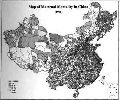
Fig. 2 is the map of maternal mortality in China 1996.
- Making divisions for crop yield estimating y remote sensing in
China.
Food supply is a global problem faced by our human beings especially for China where 22 percent of the worlds population live. The crop production plays an important role in the economic development , living standard of people and social stability in China. The means for estimating crop output has been gradually improve by the application of remote sensing and GIS. S not only could the final output be estimated , but also the growing status of the crops could be monitored , the effective measures could be adopted timely at different situation in order to achieve steady increase of the output . in a recent research , with CSDAMS two divisions , the division based on planning areas, of the main crops and division based n yield ( please refer to fig. 3), for yield estimating by remote sensing have been made. And suggestion have been given to choose sample regions. Each of these divisions has two levels. The first level divisions of the two divisions are the same. But the second divisions of them are different.
Agricultural planting division has been used as the first level division . the agricultural planting division has been made in 1980's by using large geomorphic units as their main indicators, together with the conditions of light , temperature, water and soil . it includes 11 categories of crop production areas with different natural conditions, production characteristics and yield levels.
The second level division based on planting areas of the main crop has been made by clustering all the units into 44 categories . within each category, the types of the crops and the proportion of all the units are similar . the plating areas of the different crop sand the crop index have been used in clustering . the second level division based on yield has been obtained by clustering all the units in to 39 categories . within each category, the types of crop production of all the units are similar . so the growing status of the crops , sampling and the time for yield estimating are also similar . the yields of the crops as well as phonological information have been used in clustering.
Through applications , the software system has been tested . the performance and function of CSDAMS have been being improved continuously. The decision -making ability will be enhanced in the future . naturally CSDAMS will play a more and more important role in planning, management and decision making gradually.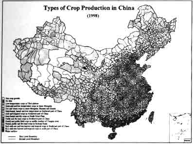
Fig. 3 Map of Types of Crop Production in China
- Yan, S.Y., 1995, Exploration of the General Framework for GIS Development in China GIS Information World, (4)
- Yan, S.Y., 1995, Modern Remote Sensing Technical System and its Development Trends, Chinese Remote Sensing of Environment,10(1)
- Yan, S.Y., and et al: A Logical Model of Urban Environment Management Information System , Presented to the Workshop On GIS, Nov, 1998 , Bangkok, Thailand.
- Wangqioa, Yan shouyong, Region planning model its administration in GIS, Yuhang Press ,1998.