| GISdevelopment.net ---> AARS ---> ACRS 1998 ---> Poster Session 3 |
Difference in observation of
Indonesian fire by DMSP-OLS and NOAA-AVHRR
Mikiyasu
Nakayama
Faculty of Agriculture, Utsunomiya University
350 mine-machi, Utsunomiya Tochigi 321-8505, Japan.
Tel: +81-28-649-5495 Fax: +81-28-649-5508
E-mail: nakauyama@utsunomiya-u.ac.jp
Abstract Faculty of Agriculture, Utsunomiya University
350 mine-machi, Utsunomiya Tochigi 321-8505, Japan.
Tel: +81-28-649-5495 Fax: +81-28-649-5508
E-mail: nakauyama@utsunomiya-u.ac.jp
Satellite remote sensing is a useful tool to monitor forest fire. While monitoring of forest fire has so far been performed mostly using one sensor. This study aims at developing a methodology with a view to identifying the progress of the forest fire to Indonesian using multiple sensors namely DMSP-OLS and NOAA-AVHRR. The study area was established in Sumatra Island. The period from 26 October to 7 November 1997 was chosen for this study. "Hot spots" were identified with NOAA-AVHRR nighttime imagery and "fire flares" with DMSP-OLS data. Both "hot spots" and "fire flares" detected were compared, so that relative advantage and disadvantages of two sensors may be evaluated. A number of forest fires were detected initially as "fire flares" by DMSP-OLS, much sooner than being detected as "hot spots" by NOAA-AVHRR. It was presumably because NOAA-AVHRR often fails to detect "hot spot" at the onset of a fire owing to haze. Some fires failed to be detected as "fire flares" by DMSP-OLS, while they were detected as "hot sports" by NOAA-AVHRR. It may be because NOAA-AVHRR detected forest fires as hot spots even in "smoldering phase" of forest fires.
Introduction
The forest fire in Indonesia has given many adverse impacts both on natural resources and humanity. Such harms were not only found within Indonesian. For example, slack in tourism by haze in Thailand and Malaysia has been observed in the past. Decrease in tropical rain forest is a global environment threat. Monitoring of forest fire in Indonesia thus has utmost importance. Satellite remote sensing is a useful tool for this sake to cover the wide area. The monitoring of forest fire has been performed mostly using one sensor. However, in case of forest fire observed in Indonesia in 1997, it was difficult to identify the progress of fire under persistent cloud and haze only with a single sensor such as NOAA-AVHRR. The purpose of this study is to develop a "methodology with a view to identifying the progress of the forest fire in Indonesia using multiple sensors with different characteristics. As the first step for the sake, the imagery obtained by Operational Linescan System on the Defense Meteorological Satellite Program (DMSP-OLS) and by the NOAA-AVHRR were compared in order to find out both the advantages and disadvantages of these sensors.
Study area
The study area for fire detection was established in Sumatra Island within a box spanning the region from 1.9 to 2.5". S in latitude and 104.3 to 1.04.8° E. in longitude (figure 1). Indonesia is known the most 'cloudy' region in the world. The Sumatra Island was chosen for this study because cloud cover in this area was found less than other areas in Indonesia.
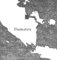
Figure 1 Study area
Sensor Characteristics
DMSP-OLS
The DMSP-OLS has a unique capability to detect low levels of visible-near infrared (VNIR) radiance at night. With the OLS "VNIR" band data it is possible to detect clouds illuminated by moonlight, lights from cities, towns, industrial sites, gas flares, and ephemeral events such as fires and lighting illuminated clouds (Elvidge, et. al., 1997). Spatial resolution of DMSP-OLS is 2.7 km, and swath is 3000 km. DMSP-OLS is supposed to have advantages over other sensors in fire detection, for cloud cover in nighttime is generally less than in daytime. Moreover, DMSP-OLS could detect fire flares even through thin cloud or haze thanks to very high sensitivity of the sensors in VNIR band. A disadvantage of the DMSP-OLS sensor is that nighttime data may be obtained only for eight days each before or after new moon. It is because the VNIR sensor causes saturation when the ground surface is lit with moonlight.
NOAA-AVHRR
AVHRR is a canning radiometer on board NOAA's Polar Orbiting Environmental Satellite (POES) which measure reflected and emitted radiation at approximately 1 km spatial resolution, with swath of 2700km, in five channels ranging from 0.5 to 12.5mm. Sub-pixel temperature targets can be identified in the short wave infrared data (channel 3 in AVHRR) during nighttime because these feature have greater effect in the 3.5-4.0 mm wavelength than in the longer wave infrared bands.
Data used for Analysis
The period from 26 October to 7 November 1997 was chosen for this study, for fairly cloud-free DMSP-OLS data were obtained almost everyday in this period. Cloud-free NOAA-AVHRR nighttime data of this study area were captured on 26 October, 31 October, 3 November, 4 November, and 7 November. The amount of available cloud-free data suggests that DMSP-OLS is superior to NOAA-AVHRR in terms of availability of data suitable for fire detection.
Methodology
The procedure used for this study is as follows : (a) "Hot spots" were identified with NOAA-AVHRR nighttime data by the improved contextual algorithm (Nakayama, et. al., 1998). (b) Fire flares were identified as faint "light" in imagery of DMSP-OLS using the methodology as described in (Elvidge, et. al., 1997) (c) Both "hot spots" detected by NOAA-AVHRR and "fire flares" by DMSP-OLS were compared for cloud-free areas. (d) Relative advantages and disadvantages of two sensors were evaluated.
Results and Discussion
Figure 2 shows "hot spots" detected by NOAA-AVHRR and "fire flares" detected by DMSP-OLS on 31 October. The figure suggests that more forest fires could be detected by DMSP-OLS as "fire flares" than by NOAA-AVHRR as "hot spots". The "fire flares" detected by DMSP-OLS found spatially broad, which is presumably due to scattering of scattering of lights by prevailing thin haze. Table 1 shows the dates when those fires were detected by NOAA-AVHRR or by DMSP-OLS in the study area. The "hot spots" detected by NOAA-AVHRR on 3 November serve as reference for table 1.
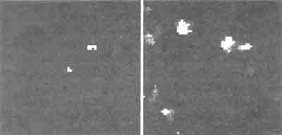
Figure 2 Hot spot detected NOAA-AVHRR & Fire detected by DMSP-OLS
A number of forest fires were detected initially as "fire flares" by DMSP-OLS, much sooner than being detected as "hot sports" by NOAA-AVHRR. It was presumably because NOAA-AVHRR often fails to detect "hot spots" at the onset of a fire owing to haze, while DMSP-OLS could detect "first flash" of a fire flare flawlessly. Figure 3 shows "hot spots" detected by NOAA-AVHRR, "fire flares" detected by DMSP-OS on 3 November. Some fires failed to be detected as "fire flares" by DMSP-OLS, while they were detected as "hot spots" by preat, it sounds likely that NOAA-AVHRR detected forest fires as hot spots, even in "smoldering phase" of forest fires, which is particular to the prevailing peatlands in the study area.
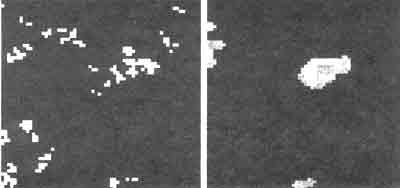
Figure 3 Hot spot detected NOAA-AVHRR & Fire detected by DMSP-OLS
Conclusion
The multiple sensor approach was proved much more useful in monitoring the progress of a forest fire in Indonesia throughout its burning process vis-à-vis monitoring the same fire only with a single sensor. Further efforts are still required in the following aspects : (a) Development of a methodology to pinpoint a forest fire with DMSP-OLS, which has coarser resolution than NOAA-AVHRR (b) Identification of the reason why DMSP-OLS can detect a forest fire much sooner than NOAA-AVHRR. In other words, it should be examined why "fire flares" may be observed with DMSP-OLS much sooner than NOAA-AVHRR's detecting the same forest fire as "hot spots".
References
- Elvigde, C. D., et. al. (1997): Mapping City Light With Nighttime Data From the DMSP Operational Linescan System, Photogrammetric Engineering & Remote Sensing, 63, 727-734.
- Nakayama M. et. al. (1998): Contextual Algorithm Adapted for Fire Detection in Indonesia, International Journal of Remote Sensing, submitted.