| GISdevelopment.net ---> AARS ---> ACRS 1998 ---> Poster Session 2 |
Automatic Approach for
Assessing forest Disasters Utilizing Simulated High Resolution Satellite
Imagery
Tomokazu Hoshino, Tsutomu
Suzuki, Tomoyuki Suhama and Krishna Kumar Mishra
PASCO Corporation
1-1-2, Higashiyama, Meguro-ku, Tokyo 153-0043, Japan
Tel: (81)-3-3715-1530 , Fax : (81)-3-3715-1470
E-mail: tomokazu_hoshino@sed.pasco.co.jp
AbstractPASCO Corporation
1-1-2, Higashiyama, Meguro-ku, Tokyo 153-0043, Japan
Tel: (81)-3-3715-1530 , Fax : (81)-3-3715-1470
E-mail: tomokazu_hoshino@sed.pasco.co.jp
A system to timely monitor and assess forest disaster has recently been developed. Forest Disaster Assessment System (FDAS) integrates GIS and simulated high-resolution satellite images for providing an immediate response to forest disaster. FDAS can also be installed on the notebook computer and used in the fields for analysis purposes. It allows visualizing, analyzing, and modeling graphic information and automatic reporting to supply valuable information managers.
Introduction
A system was developed for Forestry Agency in Fukuoka Prefecture to prepare the reports and monitor the forest damages and landslides in the mountains due to the disaster caused by typhoons and heavy rainfall in the region. It is very important to timely grasp and report the wide forested area damaged by natural disaster for monitoring purposes. In the recent years, for protecting the damage area, various analysis procedures have been developed utilizing the integrated approach of Remote Sensing and Geographic Information System (GIS). Imminent operations of high-resolution commercial remote sensing satellite, previously unavailable for public use, will be able to provide 1-meter panchromatic resolution for vital environmental monitoring purposes. The recent technologies advance has been made possible the downsizing and price reduction of GIS and related products. The GIS software installations on the notebook computers with speeds and storage capacities are becoming popular these days.
Considering the importance for grasping the damage forest area, a rapid reporting methodology was developed in the PASCO Corporation, Forest Disaster Assessment System (FDAS), utilizing simulated high-resolution satellite images. In the present study the aerial photographs were utilized for detecting the damaged areas with advance data analysis methods for more rapidly preparing repots. The function of this system can create forest register indicating various kinds of information on the forest disaster extracted from the high-resolution satellite images. The results were utilized for assessing various damaged and preparation on the screen. This system helps users to visualize alternative solutions graphically and preparation of reporting work utilizing remote sensing and GIS technologies for grasping the information on damaged caused by disasters.
Methodology
(i) Study area and data sets
The Kurogi Town, which was selected for this study, is surrounded by the forests and mountains in the Fukuoka Prefecture of Kyushu Island, Japan (Figure 1).
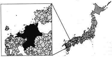
Figure.1 Study area in Fukuoka Prefecture
The SPOT satellite data and simulated high-resolution images from the aerial photographs were used for extracting the information on disaster. The aerial photographs were scanned and resampling was done to generate 1-meter high-resolution image. The utilized data are mentioned in Table 1.
| No. | Type of the data utilized in FDAS development | Acquisition date (before disaster) | Acquisition date (after disaster) | Area coverage |
| 1. | SPOT XS (Multispectral) | 1988, Oct. 7 | 1994, Oct. 18 | Total area |
| 2. | SPOT PA (Panchromatic) | 1990, Apr. 26 | 1994, Apr. 14 | Total area |
| 3. | Aerial Photograph (AP) showing opening of the forest road in 1991 | 1991, May | 1996, May | Area - A |
| 4. | AP showing forest damage of Typhoon in 1991 | 1991, May | 1991, Oct | Area - B |
| 5. | AP showing forest damage of typhoon in 1991 | 1991, May | 1991, Oct | Area - C |
| 6. | AP showing forest damage of typhoon in 1991 | 1991, May | 1991, Oct | Area - D |
| 7. | AP showing forest damage of typhoon in 1991 | 1991, May | 1991, Oct | Area - E |
| 8. | AP showing damage forest roads in 1991 | 1991, May | 1996, May | Area - F |
| 9. | AP showing damage forest roads in 1991 | 1991, May | 1996, May | Area - G |
| 10. | AP showing Landslides in 1993 | 1991, May | 1996, May | Area - H |
(ii) Forest data sets
The forest planning maps at 1:5,000 scales corresponding to one unit of 4 ha (200m X 200m) were digitized showing the damaged forest administrative boundaries and register book information were entered, linked and stored in the FDAS.
(iii) Concept of the FDAS
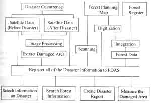
Figure 2. Concept of the Forest Disaster Assessment System (FDAS)
The conceptual diagram is shown in Figure 2. The low cost GIS software package utilizing high-resolution images for automated mapping, analysis and reporting are the concepts of this system. The damaged areas are extracted from high-resolution satellite image after the disaster and the data on forest register and damaged areas are entered to the system. The predetermined information an damaged areas are automatically calculated for report preparation. The system enables forest managers to easily integrate and use available tabular and map information source to make better decisions.
(iv) Extraction of the information on damaged areas
The satellite images, before and after the disaster, are superimposed for two different seasons and detection of the affected area is extracted by image classification using image processing software by spectral signature similarity (correlation analysis) (Inamura et al., 1982 and Yasuoka et al., 1988). The images are classified for the information and soil situation, fallen trees, eroded area (due to the landslide) etc. the classified images are compared for correlation analysis and brightness comparison is preformed. Depending upon the analysis result, for extracted information on damaged areas, the most suitable analysis technique is adopted.
Result and discussion
(i) Functions of FDAS
The basis and function of FDAS is shown in Figure 3. The system is handled in Arc View Version 3 and operated on Windows 95 as a desktop version with ARC/INFO. FDAS has been developed using Visual Basic in conjunction with Arc View Version 3 and Microsoft Excel on Windows 95 or Windows NT.
| Register new information on damage | Display damaged areas | Measure damaged areas | Search forest register (automatic) | Measure landslide quantity | Calculate damage information (automatic) | Report preparation (automatic) | |||||||
| ArcView Version 3 (Desk Top GIS) |  |
Microsoft Excel | |||||||||||
| Window95 or WindowsNT | |||||||||||||
Figure 4 shows the screen display of the system. When the system starts, a main window is always indicated on the top of the screen with menus and tool bars for assisting modules. The sub-menu indicates the function on various information about the forest damage depending on the menu selection (Figure 5). The map window displays map and image.
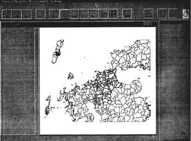
Figure.4 General screen display and main menus
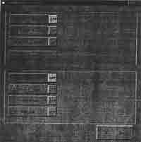
Figure.5 Sub-menus for disaster type and location
On specifying a position for the damaged areas, it gives the information about the distance from city ®country® town® village and from forest group ® subgroup and their listing on forest information.
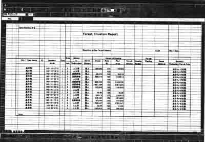
Figure.6 An example of the report
The range of the damaged areas can be selected from the results of the references. The damaged areas and satellite image can be indicated on the top of the screen and analysis can be done. FDAS user can automatically obtain the corresponding geographic location in response to the mouse location. The result about the damaged areas is displayed as table(s) in Excel document for reporting (Figure 6).
Conclusions
FDAS is developed considering the utilization of the high-resolution commercial remote sensing satellite, recently or soon to be launched, for forest management planning. The system utilizes the digital information for automatic reporting about the areas affected by disasters which was previously a manual process. This system can be installed on the notebook computer and used on-site and for the network communication as well. The analyzed aerial photographs were monochrome of single band with limited spectral information and therefore the amount of disaster expect the hillside/mountain stream disaster. Further improvement with increased precision are required for high-resolution satellite images. Image handling and preparation of supporting tool with advance image processing technique and integration with GIS will be more effective with high-resolution satellite image for the forest management purposes.
Acknowledgements
The authors are thankful to the Fukuoka Prefecture for their continuous support to supply the necessary information during the study.
References
- Inamura M., Toyota H., and Fujimura S., 1982. Exterior algebraic processing for remote sensed multispectral and multitemporal images, IEEEE Trans. Geosci. Remote sensing, 20 (1), 112-118.
- Yasuoka et al., 1988. Detection of Land-cover change from remotely sensed image using spectral signature similarity, Proc. Ninth Asian Conf. Remote Sens., Nov. 1988, pp. G-3-1-G-3-6.