| GISdevelopment.net ---> AARS ---> ACRS 1998 ---> Poster Session 2 |
GIS-Assisted Parcellary
approach to Land use Mapping for local Government Units in the
Philippines
Mr. Love A. Panaguiton
GIS Specialist , UP PLANADES, Inc.
School of Urban and Regional Planning,
University of the Philippines at Diliman ,
Quezon City , Philippines
Tel: (632) 927-47-97 Fax: (632) 927-35-95
E-mail : love@surp.upd.edu.ph
Abstract GIS Specialist , UP PLANADES, Inc.
School of Urban and Regional Planning,
University of the Philippines at Diliman ,
Quezon City , Philippines
Tel: (632) 927-47-97 Fax: (632) 927-35-95
E-mail : love@surp.upd.edu.ph
Land use mapping has ever since played a major role in the formulation of the land use Plans of the Local Government Units in the country. Using maps to compliment the planning activity, there is a need for a ore, updated and accessible information f the area under study . this is necessary to support the basic information requirements of the local government units to effectively strategize the development expansion of their respective area.
This paper hopes to review the process that has been successfully applied by various Local Government Units through the adoption of the Paracellary Method in exercising land use mapping. This is a community based " walk through" approach of determining individual uses of parcels in the locality.
Though tedious and time-consuming process, it address the perennial problem of delineating administrative boundaries and individual parcel definition in preparing land use plans. Using Geographic Information System (GIS), it is possible to validate and update the land information status of the locality faster where it takes manual mapping days and weeks to do.
Introduction and Background of the Study
It has been a usual practice for t past years for Local Government units (LGUs) to make use of various maps that are readily available for their land use plans. Sources of these are based on hand -drawn maps in which these features were delineated by manual techniques . with the availability of the maps extracted from aerial photos, natural features such as terrain and river system become more accurate in their location on the ground . However, features like road network and administrative boundaries remain loose in their geographic location such that problems such as boundary dispute arises during the course of planning activity.
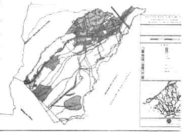
The current technique being employed by most LGUs in determining the existing land use of the area is by estimating the extent of the boundary of a particular use in the map . a typical example of this approach is shown below. This method is unreliable because boundaries of land uses cannot be located on their exact position on the ground. It does not cluster land uses interims of administrative boundaries which local executives can have a macro perspective of what is gong on in every barangay. Moreover , area and distance between different uses cannot be determined exactly as to the number of parcels being classified per use.
Previously, there have been some efforts to make use of parcellary maps for land use mapping, however , the difficulty in integrating these individual sheets into a base map poses a problem to the planners . with the advent of the technology such as GIS, it is now possible a more fair and accurate result especially in the creation f the basic of e input the land use map.
Normally, most of the maps being use for land use mapping utilize NAMRIA's Provincial Maps and the Topographic maps (700 series ) with a scales of 1:50,000 derived form aerial photos . for this method, the cadastre maps will be tapped as the primary sources of data . These maps have been the result of the actual ground survey of the locality which individual parcels have its own geographic coordinates . it is expected that some of these maps were no longer available in the custody of the Record section of the land Management Service -DENR because most of these mps were already old and dilapidated. Somehow, the availability of the Real Property Tax Maps in the Assessor's Office of the LGU will be used as a supplement to the vacancy of the cadastral sheets .
Methodology
The methodology involved in implementing this method involves the following steps:
A : Data Sourcing
It is necessary to secure all the complete list of cadastral maps pertaining to he locality form the Land Management Bureau (LMB-DENR) Regional Office Records Section where the municipality/ city belongs. In cases where , the area is covered by different survey modules , all maps with survey numbers pertaining to the area of interest should also be retrieved form the records.
In cases where there are missing parcellry sheets , it is necessary to retrieve the complete and current tax maps from the office of the Assessor-Tax Mapping Division to supply the missing parcellry entries . since tax maps are based from the technical descriptions as appearing in the transfer Certificate of Titles (TCTs) of individual owners and old cadastral maps, updating of the cadastral sheets is possible . the idea of obtaining status of the data . information such as listings of current owners can be used as a reference to e respective cadastral lots as appearing in the roll. Initially, it will serve as the parcellry database attribute of the lots and can be modified though the addition of other lot information .
B. Data Build-up
The use of the geographic Information System (GIS) process of digitization cab capture parcellary details in the cadastral maps. All parcels will be tagged with their respective unique individual cadastral lot numbers. This will serve as the primary link of the attributes to the parcels in the map.
Barangay boundaries are also extracted in t cadastral map to show which parcels are located or belonging to a certain barangay. This is always defined by the Barangay Boundary Monuments (BBM). In case where barangay boundaries are not defined or lacking in the cadastral sheets, reference should be made to the boundary used by the particular tax map sheet.
It is important to note that, in most cases, barangay boundaries appearing in the tax map sheets does not necessarily correlate with the boundaries appearing in the cadastral sheets. This is because they have a different basis of boundary delineation where tax maps are used for taxation purposes.
In case where boundary disputes arise , boundaries in the cadastral sheets will always prevail s the official barangay boundaries.
All over features shall be inputted to the computer including the waterways, road network and other important landmarks, which can be of help to the land use planners in locating parcels in the ground.
C. Field Work
Before the start of the fieldwork survey, Barangay land Use Survey ( BLUS) training shall be performed to the personnel who will be involved in the activity. The use of maps and other signage will be explained noting the importance of the data to be gathered . it should be stressed that the determination of individual land uses in a particular parcel should be based on Housing and Land Use Regulatory Board (HLURB)'s guidelines in land use mapping. Color-coding must be strictly observed as not to confuse different uses of parcels.
Individual barangay printouts should be distributed to the field surveyors for their reference with the administrative boundaries. This includes the parcels located with in respective barangay with their corresponding lot numbers and owners.
When assistance is necessary, the help of the local barangay officials will be tapped because they are the ones who are more familiar of the area. This hastens and facilitates the mapping activity.
After the fieldwork, all barangay maps used will be turnover to the technical person for integration of the result. The technical person will be guided and informed of the data , which are doubtful and misrepresented in the map .in case where there area conflicting data results , its is normally elevated to the judgment of the land use planner for the decision.
Discussion
Land supply plays the most important resource to be considered in land use planning for the local government units . it determines the horizontal limits of areas for development to accommodate the growing settlements and human activity.
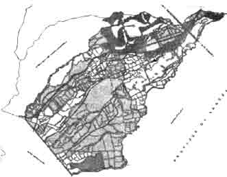
With the use of the parcellary approach to land use mapping , there will be an inventory of the individual parcels as to area and ownership . Zonal classification of individual parcels is possible because all are tagged by their respective cadastral lot numbers . examples of the same area shown in the previous map.
These cadastral maps will be complemented by Real Property Tax maps (RPTM) in t preparation of the base map of the locality . once it is setup, mapping revision is easier and cab be used for other applications such as Real Property Tax computerization & Assessment System (RPRCAS ) and Land Information System (LIS) . summary of land uses with its corresponding actual areas cab be laid in matrix form that can be beneficial to the local executives in decision making process.
Conclusion
The use of GIS as a tool in land use mapping enhances the mapping function of the local government in displaying the wealth of its land resources and the potential to efficiently utilize it for future use. The adoption of this approach further helps the LGU to enhance decision-making capability of the local executives in enforcing laws that would somehow influence the basic services that directly affect the lives of the local population .
Though there is no such thing as perfectly land use map, the accuracy of the data being use matters considerably. The local Zoning Ordinance, which hails form the proposed land use plan , has a direst implication to the lives of the local population . when this is enforced, actual parcels affected are visually seen on the map.
Eventually, the Local Government Units can be able to monitor with ease the developments happening in locality and problems such as unwanted developments can be avoided.
Reference:
- Carmona Comprehensive Development Plan -UP PLANADES, Inc.
- ken Schmidt, " Establishing GIS Functionality in the Operations of Local Government ". Dept. of Land Utilization, Honolulu, Hawaii.