| GISdevelopment.net ---> AARS ---> ACRS 1998 ---> Poster Session 1 |
Dual Channel Algorithm for
Retrieval of Sea Surface Temperatures from Satellite Thermal Images
Khiruddin
Abdullah1, Nasirun Mohd Saleh1, Yusuf
Mahmood1, Ruslan Rainis1,M.Z Mat Jafri1,
Ahmad Tajuddin Khader1, Alui Bahari2
1Universiti Sains Malaysia, 2Malaysian Meteorological Services
Abstract 1Universiti Sains Malaysia, 2Malaysian Meteorological Services
A study was conducted to test the performance of the developed dual channel sea surface temperature (SST) algorithm. The algorithm was derived based on the radioative transfer equation in the atmosphere. The difference in the derivation of this algorithm form the established algorithms is that it does not require the sea truth data for calibration. For this preliminary study, data from South East Asia equatorial region were used. The algorithm was applied to Advanced Very High Resolution Radiometer (AVHRR) and Ocean Color Temperature Scanner (OCTS) data. The relative performance of this developed algorithm and the national Oceanic and Atmospheric Administration Multi-Channel Sea Surface Temperature (NOAA MCSST) algorithm for retrieval of SST was compared. Similarly, the comparison was made using the National Space Development Agency of Japan (NASDA) MCSST. The reliability of this algorithm was then assessed using the corresponding ship collected SST values.
Introduction
Although conventional shipboard sea surface temperature measurement produce accurate readings but technique is rather slow and expensive. An alternative reliable method can be achieved from satellite measurements. For example, accurate retrieval of SST using AVHRR data can be computed using the established algorithms produced by NOAA. Data from OCTS have been successfully used to perform this task and the algorithm has been developed by NASDA for operational use. However, we require an algorithm which can be used to measure SST using thermal images from any satellite. The purpose of the study is to test the developed algorithm using data sets from different satellites and compare its performance with the established algorithms.
Sea surface temperature algorithm
Based on the radioative transfer equation in the atmosphere for a cloud free atmosphere under local thermodynamic equilibrium a single channel algorithm can be derived for measuring sea surface temperature for infrared band i. By writing the equation for another band j, we can finally obtain a split window expression or dual-channel algorithm (Khiruddin et al. 1993, Khiruddin 1994) for measuring sea surface temperature, Ts
where
Ti=brightness temperatures of band i
L(Ti)=(1-exp(-c2ki/Ti)Ti2/c2ki
ki = the wavenumber for band i
c2=1.438833 cm K
ai = eiti
bi = (1-ti) (1+ti-ei ti)
ei = emissivity of sea water in bank i
ti = atmospheric tranmittance
In order to apply the above equation we have to estimate the atmosphere transmittance t i. Water vapor is considered as the prime constituents in the absorbing materials in the modeling of the transmittance functions for the thermal infrared brands. Inspection of the LOWTRAN results suggests that it can be approximated by the expression.
where W is the water vapour and is the satellite zenith angle at the pixel location. To determine it will require the knowledge of the atmospheric conditions in the region of its application. This information can be obtained from the observed atmospheric profiles such as from the radiosonde data. In case this local information is not available the relevant standard atmosphere model can be used instead. The coefficients t1 and t2 were determined from regression analysis. Having determine the values for the transmittance as a function of water vapour concentration., zenith angle and the emissivity of sea water for each band, equation (1) can be applied to measure SST. This function can be used for atmospheric at any satellite angle or on a pixel-by-pixel basis.
Estimation of sea surface temperature
Analysis of AVHRR data
The cloud free sea water pixels (after cloud masking process) for bands 4 and 5 were extracted for further study. The transmittance functions for the tropical model were used. Nine scenes acquired between June 1996 and November 1996 were analysed. The calculated Ts values were then compared with those calculated using the MCSST algorithm produced by the NOAA for the NOAA-12 satellite (Kidwell 1995).
The result of the analysis indicated that the developed algorithm (eq. 1) produced very high correlation with the results from NOAA MCSST algorithm (correlation, R = 0.99; RMS error = 0.83°C) as shown in figure 1. The relative performance of these algorithms were then assessed by comparing with the in-situ collected data. The problem arose was that all the in-situ data location were either on cloudy pixels or outside the scenes. However, we discovered that only a few of the in-situ points were close to the cloud free pixels of the corresponding image dates. The results are shown in Table 1. Equation (1) yielded SST values closers to the in-situ SSTs as shown in Figure 2.
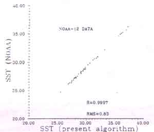
Figure 1. SST from NOAA algorithms vs. SST from equation (1)
| Date | In-situ (SST(°C) | SST from eq. (1) (°C) | SST from NOAA (°C) |
| 2 July 1996 | 30.0 | 29.1 | 28.3 |
| 20 July 1996 | 31.0 | 29.2 | 28.4 |
| 3 Nov 1996 | 31.0 | 30.9 | 29.4 |
Observation of the in-situ data included that the SST values were within the same range throughout the year in the studied region and the temperature difference was about 1°C. Therefore, in order to overcome the problem of unavailability of coincident in-situ data with cloud free pixels, we averaged the SST from cloud free pixels and then compared with the average of the in-situ values for each scene. The summary is shown in Table 2. From the table was can infer with the present algorithm produced better correlation with the in-situ, which is 1.3°C, whereas for NOAA algorithm is 1.7°C. The NOAA algorithm give slightly greater deviations and consistently lower values.
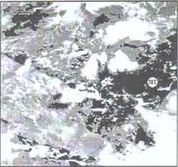
Figure 2. AVHRR image of 2 July 1996 with coincident in-situ SST of 30°C. Equation (1) Produced temperature of 29.1°C and NOAA MCSST gave 28.3°C.
| Date | in-situ SST (°C) |
SST from eq. (1) (°C) |
SST from NOAA (°C) |
| 28 June 1996 | 30.7 | 31.8 | 29.9 |
| 2 Jul 1996 | 29.9 | 29.4 | 28.4 |
| 14 Sep 1996 | 29.1 | 29.1 | 28.5 |
| 15 Oct 1996 | 30.3 | 29.8 | 29.1 |
| 16 Oct 1996 | 30.6 | 29.6 | 27.6 |
| 3 Nov 1996 | 29.9 | 29.0 | 28.2 |
| 4 Nov 1996 | 29.0 | 31.9 | 31.1 |
Analysis of Ocean Colour Temperature Scanner (OCTS) data
The algorithm was later tested with OCTS data sets. Five scenes were selected from the Remote Sensing Technology of Japan (RESTEC) archive and they were captured by ADEOS satellite on 22 March 1997, 21 April 1997, 24 May 1997, 13 June 1997 and 21 June 1997.
Similar analyses performed earlier were carried out with OCTS data sets. Cloud free sea water pixels for bands 10, 11 and 12 were extracted for SST retrieval. The digital numbers were converted to brightness temperatures using the calibration parameters produced by NASDA. The SST values were computed using equation (1) and then compared with the values retrieved using equation (4) below developed by NASDA (Sakaida et al. 1998).
The coefficient C0 To C5 were taken from the table provided in the report. The results produced by the algorithm of equation (1) were correlated with the output from equation (4) and the RMS errors were estimated. Again with these data sets the present algorithm has shown comparable performance with the established algorithm produced by NASDA as indicted by high correlation coefficients and small RMS errors shown in table 3. The plot in Figure 3 indicate the correlation between the two considered algorithms.
| Date | Correlation coefficient | RMS error |
| 23 March 1997 | 0.99 | 0.43 |
| 21 April 1997 | 0.99 | 0.46 |
| 24 May 1997 | 0.99 | 0.66 |
| 13 June 1997 | 0.99 | 0.16 |
| 21 June 1997 | 0.99 | 0.43 |
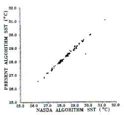
Figure 3. SST from equation (1) vs. SST from NASDA MCSST for 13 June 1997 data.
Conclusion
The results of the study indicated that the performance of the developed algorithm is comparable to the established algorithms such as NOAA MCSST for retrieval of SST using AVHRR data and NASDA MCSST for application of OCTS data. However, this algorithm produced better accuracy than the NOAA MCSST for SST determination in sea water areas around Malaysia. This is due to this algorithm takes into account of the local atmospheric condition. Although coincident in-situ data were not available for comparison using OCTS data but the computed values were in order of magnitude of the local readings as given in the reference in-situ data and they are highly correlated with the NASDA MCSST computed values. The present study has indicated that it is possible to use this algorithm globally without resource to the local in-situ data for calibration. This will be verified by pursuing further research. The atmospheric profiles from radiosonde are required data for obtaining transmittance values corresponding to the scenes used and coincident SST for more accurate verification.
Acknowledgements
The authors like to thank the Universiti Sains Malaysia for funding the project involving AVHRR data, the Malaysian Meteorological Services for providing the AVHRR images and in-situ SST readings, ESCAP and NASDA for providing financial support and ADEOS OCTS data, RESTEC, our students Murali Shangkar, Jeru Iruthaya Nathan, Lee Eng Hou, Yan Wai Hong and our research officer Tadris Ahmad for their helps.
Reference
- Khiruddin Abdullah, Cracknell, A. P., Vaughan, R. A., 1993, Atmospheric correction for thermal infrared data on a pixel basis - comparison between AVHRR and MOS VTIR data. Presented at 13th EARSel Symposium held in Dundee, 2-5 July 1993.
- Khiruddin Abdullah, 1994. The use of satellite data in studying geophysical and biological aspects for coastal waters. PhD Thesis, University of Dundee.
- Kidwell, K. B., 1995, NOAA Polar Orbiter data user guide, NOAA, Washington DC.
- Sakaida, F., M. Moriyama, H. Murakami, H. Oaku, Y. Mitomi and H. Kawamura, 1988, The sea surface temperature product algorithm of the Ocean Colour Temperature Scanner (OCTS)/ADEOS-1 and its accuracy. Draft Report.