| GISdevelopment.net ---> AARS ---> ACRS 1998 ---> Poster Session 1 |
Forest Burned Area Mapping by
using SPOT Images
Gwo-Jern Hwant1
Wen-Fu Chen2
Keywords: remote
sensing, forest fire, pseudo color images, aerial photograph, working
circle, map overlay, geographic information system.
Abstract
The objective of this research is to apply remote sensing technique to investigate the methodology of mapping forest fire burned area. SPOT HRV were used to compare with the panoramic aerial photo mapped forest fire burned areas in this research. The areas included Yu-Shan working circle and Hsiu-Ku-Luan working circle in Taiwan. Each was independently interpreted and the results were compared and analyzed by map overlay utilized geographic information system software Arc/Info. The resulted precision rate of calculated burned interpreted from aerial photograph was 98.1%. It is worthwhile.
- Technician of, Bureau of Forestry of Taiwan Province, ROC
- Prof. of National Chung-Hsing Univ. Tai-Chung, Taiwan, ROC
Forest fire affects ecology seriously, it will break even erode the soil. The most important thing we must to do during the forest is being fired are fire fighting and the firing area control. In order to prevent forest fire, Taiwan Forestry Bureau has used various method of fire prevention broadcast and taken fire-prevention workshops to remind and warm the fire fighter of hot-spot location to check the safety during dry season. On the other hand, in order to enhance the forester to learn various fires fighting skill, the Forest Bureau evaluate the work at the end of year.
The Forest Bureau was called by the Police Team of Yu-San National Park that a severe forest fire occurred at the connecting zone of the 51st compartment of Yu-San working circle in Yu-San National Park and the 15th compartment of Hsiu-Ku-Luan working circle at noon of 4.1.1998. The flight team was then commanded to take picture above the burning sites. Finally, was judged the fire reached the 51st and 53rd compartment of Yu-San working circle as well as the 15th and 16th compartment of Hsiu-Ku-Luan working circle. The burned area was 287.78 ha. Most of the forest fire burned area was grass land and habitat alpine sassos site and there were only few weed under Pinus Taiwanensis.
Science the Remote Sensing Development Planning Committee of Administration of Economic was erected in 1976.8. the research and application of remote sensing technique has started in Taiwan. There are four kinds of resolution in remote sensing multi-spectral bands: spatial, spectral-temporal and radiation etc., and those afford advantageous selection in application, so the remote sensing technique always be used on forest resource surveying and forest fire distribution surveying of large scale.
The purpose of this research is to utilize the SPOT images, which were taken on the forest fire burned sites at Ah-Sue-Ku Mountain area in 4. 4. 1998. The results was compared and checked with the aerial photographs of the same sites, which were taken in 4. 3. 1998. According to the accurate areas, which were estimated from the satellite remote sensing, we can help to afford the authority a more correct and quick method on estimating the area of the burned sites.
Material and Method
1. Material
- Study Sites
Hsiu-Ku Luan circle is located in Hua-Lien Forest District Office with the area of 70,429.23 ha. The space is very vast and the elevation distributes in a big range. On the high elevation distributes in a big range. On the high elevation site, there grow pure crop of Pine Tree with some Hemlock, Formosan Douglas Fir and grows grass near the ridge of Central Mountain. On the moderate elevation site, the mixed crop of Chamaecyparis Formosensis and Hemlock grow very well. On the low elevation site, there grows hardwood forest only and most of the expensive Cinnamomum Randaiense grows piecemeal at those points that the traffic is not convenient.
Yu-San working circle is located in Gia-Yi Forest District Office with the area of 49,647.77 ha. The lowest elevation of this working circle is 250 m at Dah-Pu working circle and the high elevation is 3,952m at the main peak of Yu-San Mountains. It forms a vertical zone distribution from Tropical Zone, Warm Zone, Temperate Zone and then Frigid Zone. The constitution of forest species and the forest types are very complex. - SPOT Images Data
The SPOT HRV multispectral and panchromatic level-10 images with resolution of 12.5m x 12.5m and 6.25m x 6.25m. - Land Cover Map:
Photographic Base Map (1/5,000 and 1,10,000 scale),
Compartment Base Map (1/5,000 scale).
- Delineating with Aerial Photographic Base Map.
The Forestry Bureau assigned the burned sites and then we collected the relative map data. Then taken aerial b/w and color photographs were then checked with the stereoscopes and interprets the burned area manually with photographs and finally to delineate the area boundary. After we finished interpretation with aerial photographs we selected the control points. Finally, after mapped the interpreted boundary on the circle photographic base map (1/5,000 scale) we plotted the burned area and calculated the area after digitized it. To those susceptible points we visited the field sited to check them and then remapped the burned area. - SPOT Satellite Image Appliance
- A High-Resolution Pseudo Synthetic Images Making.
Firstly, We used the SPOT MSS images to resample as RGB with resolution of 6.25m and then transform the RGB to be ISH. Secondly, we combined the panchromatic images to be three bands images and finally retransform ISH to be RGB and we got the high resolution pseudo color synthetic images - The Burned Boundary Mapping with Image Enhancement
We used GPS to assign the burned area of TM2 coordinate and then referred the circle photographic base map to locate the burned area on the satellite images. Secondarily, we enhanced the pseudo color images with linear enhancement method and then smoothed it by operating with 3*3 matrix and removed the noises. Finally, we used IMAGINE software to sharpen the edge with 5*5 matrix to figure out the boundary of the burned area obviously.
- A High-Resolution Pseudo Synthetic Images Making.
- Results from Aerial Photographic Interpretation
The area of the burned area from the aerial photograph at 4.3.1998 was 287.78 ha. The photograph was shown in Figure 1.
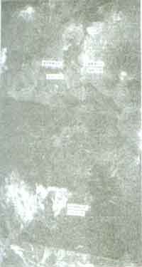
Fig 1. BW Photograph Film of Forest Burned Area
The area of the 53rd compartment of Yu-Shan working circle and the 15th & 16th compartment of Hsiu-Ku-Luan working circle were calculated and was given in table 1.
Table 1. The Burned Area of Yu-Shan Working Circle and Hsiu-Ku-Luan Working Circle (unit hectare)
Working Circle Comp. of Yu-Shan Comp. of Hsiu-Ku-Luan Total Situation 53rd comp. 15th comp. 16th comp. Serious 7.64 0.03 ---- 7.67 Moderate 2.85 50.60 28.34 81.79 Light 0.02 47.49 150.81 198.32 Total 10.51 98.12 179.15 287.78 Comp.: compartment
The disaster zone of the 53rd compartment of Yu-Shan working circle and the 15th & 16th compartment of Hsiu-Ku-Luan working circle was shown in figure 2.
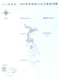
Figure 2. The Map of Equal-class of Forest Fire Disaster
- The Interpreted Results of the Satellite Images Figure 3 showed the
SPOT image of the forest fire in 4.4.1998. The area, which was in black
color, was the burned area and it was equal to 164.98a. and the white
color area was the smoke of forest fire
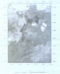
Figure 3. The interpreted forest fire map from satellite image.
- The technique of aerial phtogrammetry has being broadly used on surveying of forestry and agriculture disaster for it can afford the necessary information to the relative institute and spend less labor and cost. Although the information an be got from both aerial phtotogrammetry and satellite images classification and they can help maturely, but in case of emergent disaster the satellite images can afford information more fast.
- The resulted area was 287.78 ha from the forest fire photograph that was taken in 4.3.1998. The accuracy would be up to the proficient training, experience, the quality and kind of photograph.
- The calculated burned area 164.9ha was go from SPOT image. The precision rate was 98.1% by comparing to aerial photograph interpretation. The result was worthwhile.
- It will be a tendency for Taiwan forestry Bureau to integrate the technique of satellite remote sensing, GPS and GIS on forest fire fighting and fire danger assessment.
- Remote Sensing Training Project-Resource Satellite Data and GIS Training Project 1998 Taiwan Forest Experimental Institute
- The Report of Filling a Data Base on Agricultural Disaster Survey and Aerial Photogeimmetric Data 1998 AOC of Executive Yuan Edited Forest Bureau.
- Report of agriculture disaster surveying and the filling of photogra-mmetry data base. AOC conducted non-experiment project. Edited by Agricultural and Forest Surveying Institute of Forestry Bureau.
- Forestry Chronicle of Taiwan Republic of China, 1993, Associate of Chinese Forestry, Chinese Forestry Book Series No. 936.
- User guide manual of Disaster Treatment Team of Agricultural and Forest Surveying Institute of Forestry Bureau. 1995.
- Ho, Wei-Jeng, 1997. The workshop and forest fire fighting and prevention of Taiwan Forestry Bureau.
- The execution Project of Hua-Lien Working Circle, 1990, Hua-Lien Working Circle of Taiwan Forest Bureau.
- The Execution Project of Chia-Yi Working circle, 1990, Chia-Yi Working Circle of Taiwan Forest Bureau.
- Chau, K. M. 1987, Forestry Photogeommetry, Edited by National Edition Institute.
- Yan, C. L. Y, T. Fan, C. I. Lieu, 1997, The Report of Training Project on Forest Fire Prevention Technique (in visiting USA).
- Dai, T. T., W. F. Chen, 1997, A Study of Erecting a Change Detection System- Nankang Hillslope land of Taipei City as an Example Soil and Water Conservation Graduate Institute of National Chung-Hsing University.
- Shie, J. S, 1992, Photogeommetric Interpretation and Remote Sensing Edited by ROC PE& RS
- Liau, T. N. 1970, Forest Resource Photogeommetry.
- D. Pozo, F. J. Olmo, and L. Alados-Arboledas, 1997, Fire Detection and Growth Monitoring Using a Multi-temporal Techniques on AVHRR Mid-Infrared and Thermal channels REMOTE SENS. ENVIRON.60; 111-120
- ERICBARRETT and LEONAD FCURTIS 1992. Introduction to Environmental Remote Sensing pp 320-321. CHAMPMAN & Hall.
- Emillo Chuvieceo and M. Pilar Martin, 1994, Global Fire Mapping and Fire Danger Estimation Using AVHRR Images Photogeommetric Engineering & Remote Sensing Vol. 60, No. 5, May pp. 563-570
- Lillesand Kiefer, 1994, Remote Sensing and Images Interpretation, 3rd edition John Wiley & Sons, Inc.
- Jensen, J. R, 1986, Introductory Digital image Processing. A Remote Sensing Perspective, Prentice-Hall A Division of Simmon & Schhster, Inc.