| GISdevelopment.net ---> AARS ---> ACRS 1998 ---> Mapping From Space |
Automatic Database
Development Methods for a very Large Number of Satellite Images
Koki Iwao, ** Taizo
Yamamoto, * Ryosuke Shibasaki, *** Shiro Ochi, and *** Mitsuharu Tokunaga
*center for Spatial Information Science at the University of Tokyo
** Nippon Telegraph and Telephone Corporation
*** Institute of Industrial Science, University of Tokyo
7-22-1, Roppongi, Minato-Ku Tokyo 106-8558, Japan
Tel: (81) -3-2402-6231 (ext. 2563) Fax : (81)-3-3479-2762
E-mail : mailto:iwao@skl.iis.u-tokyo.ac.jp
Abstract
*center for Spatial Information Science at the University of Tokyo
** Nippon Telegraph and Telephone Corporation
*** Institute of Industrial Science, University of Tokyo
7-22-1, Roppongi, Minato-Ku Tokyo 106-8558, Japan
Tel: (81) -3-2402-6231 (ext. 2563) Fax : (81)-3-3479-2762
E-mail : mailto:iwao@skl.iis.u-tokyo.ac.jp
Recently, we can use many kinds of satellite images for many different objectives. And it is said that we will be able to obtain 1TB of images per day in the near future, in that sense, development of a database system for managing satellite data will be very useful. To satisfy such needs, in this research, we focused on two methods to improve the efficiency in developing database system for managing a very large number of geo-coded satellite images and raster data. Methods are (1) and automated geometric correction method for satellite images; and (2) to develop a resampling methods with high accuracy and high speed.
1.Introduction
In recent times a large volume of natural and synthetic image and grid data are being generated and becoming available. For, example, data from current images satellites like Landsat, RADARSAT, SPOT, ERS, NOAA etc. and also, there are current plans to launch more than one hundred Earth Observing Satellites by the year 2005, with 60 of those scheduled for launch by the end of 1999- with some of these satellite generating as many as 22,000 scenes per day. Digital orthophoto mapping mapping is another field in which major financial investment is being made and in which a large volume of raster data is being produced investment is being made and in which a large volume of raster data is being produced. Obviously, there will be a great chance if we can integrate these different types of data into a database. With the development of such a kind of database system, we will be able to effectively use these data for various purposes like environmental monitoring of the earth. In this research. We have focused on two methods to construct database system for managing. A very large number of geo-coded satellite images and raster data. They are-
- An automated geometric correction method for satellite images ( because we have to handle so many images, automatic system is indispensable ) and adjust geometric errors over all images based on the idea of block adjustment
- Resampling methods with high accuracy and high speed ( because the processing time and the accuracy depends on resampling methodology).
2.1 Automatic Geometric Correction Methods
For high accuracy geometric corrction , GCP ( ground control point) is indispensable . But it is not always easy to fine GCP points clearly in one scene for image coordinate registration. And geometric correction using GCP is very labor demanding. Further, traditional geometric correction methods can not be used if was fail to find good GCPs in a single scene. Therefore it is necessary to correct geometrically al these satellite images automatically for all images at same time. We propose a method to identify GCPs and tie-points in an automated manner, and to adjust geometric errors over all images based on the idea of block adjustment used in photogrammer. With this method , we can improve the efficiency and reduced the total amount of GCPs required for geometric correction. Process flow of this system is as follows
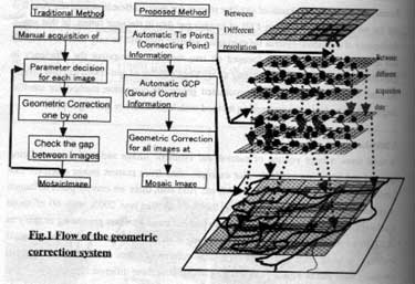
Fig .1 Flow of the geometric Correction system
2.1.2 Evaluations of the Automatic Geometric Correction Accuracy
2.1.2.1Preprocessing:
Here, we have used Landsat TM (1989, jan -may ) images as a test image . NDVI image can easily identify water body from vegetation.
2.1.2.2 Automated Acquisition of Tie Points
in the block adjustment method used n photogrammetry, tie point information need to be acquired. Tie point is the common point connecting two neighboring images. Images correlation is applied to identify the tie points . in order to check the quality and efficiency , we test the relating between template size, correlation values, calculating time and positioning accuracy. As a result, in automated acquisition of the tie points, we found that 9 by 9 pixels is the best tem plated size and that threshold value of correlation should be 0.85
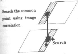
Fig .2 Tie point acquisition method
Quality check (200 samples, correlation >= 0.85)
| RMSE | 1.02 PIXEL |
| Max Error | 3 pixel |
2.1.2.3 Automated Acquisition of Ground Control point (GCP)
GCP acquisition is for determining the exact location of satellite images on digital maps of a given coordinate system like world Data Bank (WDB), Digital Chart of the World (DCW). In this process we use the information of coastal line or branch point of river system as GCPs, because it is easy to identify them in the satellite images.
To enhance water area in satellite images, we have five processes as follows .
- Genertrate a Normalized differential Vegetation Index (NDVI) images
- Detect edge of the water level slicing .
- Enhance Edge
- Remove Noise
- Thinning the Edge
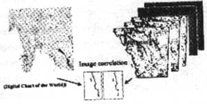
Fig .3 GCP acquisition method
2.1.2.4 Simultaneous adjustment of Images using Block Adjustment Method in photogrammetry
Using the technique of block adjustment in photogarmmetry, that is, using the tie points and the GCPs, by minimizing the error e(shown below ), we can estimate all parameters for geometric for all images simultaneously .
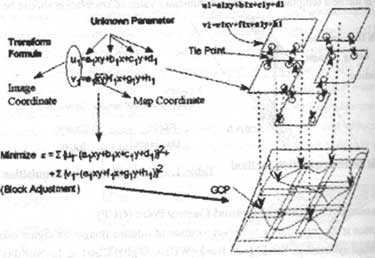
Fig 4. Block adjustment method
2.2 Proposed resampling method and spatial representation of images/raster data.
It is very important to fuse different satellite sensor images with different resolutions for earth environmental studies. In fusing or overlaying images or transforming images or transforming images onto a coordinate system. It requires to identify exact inclusion relationship between pixels and grid cells. However, in the implementation of the resampling, center position of each grid cell is transferred ot the images plane. And a pixel including transformed center point is regarded as a pixel corresponding the grid cell, which may fail to identify exact coupling relations ]especially when the grid cell size is much larger than the pixels on the ground. This comes from the footprint of pixels on the ground is not represented explicitly. Future, Resampling is computationally heavy ( a bottleneck ). In this research, to solve these problems, we propose a new resampling method together with the data model.
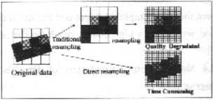
Fig 5. Problems in resampling
2.2.1 Proposed Resampling Method
step 1. Represent the shapes of footprint of Pixels on a given coordinate system
By projecting pixel boundaries or four corners on the images plane onto the ground coordinate system where the grid cells are generated, the relationship between pixel and grid can be exactly/explicitly represented. (see fig 6)
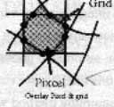
Fig.6 Relationship between pixel and grid
Step 2. Representing footprint by combination of linear features
Pixel boundaries and line boundaries can be approximated by line segments with the same intervals. This enables processing very fast computation of intersection points with grid cell boundaries ( see fig 7).
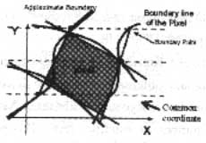
Fig 7 Step2
2.2.2 Practice and Evaluations of this Model Practice :
We applied this method for overlaying the NOAA and TM data. See Fig .8.
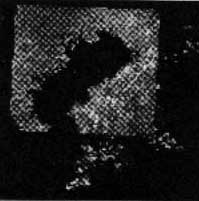
Fig 8. Overlay TM and NOAA
Time Evaluation for Resampling
Fig shows the result of time for resampling. With the proposed method, computing time depends on the grid cell numbers, whereas, with the traditional method computing time are proportional to the squared number of the grid cells. That means, we can save the time for resampling larger size of images with this method.
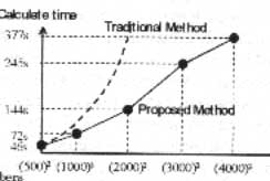
Fig 9. Time Cost Evaluation for resampling
Conclusion
so , to integrate many varieties of and huge image/ raster data, we developed two methods of automatically managing image /raster database system.
- semi-automated geometric correction method for satellite images. With this method, we can geo-code so many images semi-automatically
- Resampling method with high accuracy and high speed We can save time for resampling while keeping high accuracy
- D.I.Barnea and H.F. Silverman, " A class of algorithms for Fast Digital Images Registration ", IEEE Transaction on Computers , Vol .c-21 pp.179-186, 1972.
- W.F.Webber, " Techniques for Images registration " Proceedings of the IEEE Conference on Machine Processing or Remotely Sensed Data ,pp.1B-1 B-7, October 1973.
- C.D.McGillen and M.Svedlow, " Digital Image Processing for Remote Sensing ", IEEE press, pp 168-173, 1978
- Keisuke Katsuta , " Block Adjustment of Stero Satellite Imagery" , Proceedings of the 15 th Asian Conference on Remote Sensing, pp : F-4-1-F-4-6, vol .1, 1994
- Koki Iwao, Ryosuke Shibasaki , " Semi-automated geometric correction for Mosaicking large number of satellite data " . Proceeding of the 17 the Asian Conference on Remote Sensing, pp. F-8-1-F-8-5.
- Taizo yamanoto, Ryosuke Shibasake, " Comparative study on Image Data Model for Integrating Multiple Resolution Image /Raster Data", Proceddings of the 18 the Asian Conference on Remote Sensing, pp. Q-4-1-Q-4-6, 1997.