| GISdevelopment.net ---> AARS ---> ACRS 1998 ---> Land Use |
Total Reflected Radiance
Index -An Index To Support Land Cover Classification
Ngugen Dinh
Duong
Institute for Geography, NCST of Vietnam
Nghiado, Caugiay, Hanoi, Vietnam
Phone: 84-4-7562417
Fax: 84-4-8352483, 84-4-8361192
E-mail: duong.nd.@hn.vnn.vn
Abstract Institute for Geography, NCST of Vietnam
Nghiado, Caugiay, Hanoi, Vietnam
Phone: 84-4-7562417
Fax: 84-4-8352483, 84-4-8361192
E-mail: duong.nd.@hn.vnn.vn
In the paper the author submitted a new index that can be used for land cover classification. This index called as TRR index (Total Reflected Radiance Index) is defined as area below the spectral reflectance curve. The TRR index allows to classify ground object by its reflectance in visible and infrared region. The research have been carried out by using ADEOS-AVNIR scene number 1080, 160 observed on Apr./, 18/1997 of Danang city and surrounding area. The TRR index have been computed for several land cover categories,visualized as image and compared with standard false color composite. By only TRR index it is possible to extract high contrast object such as cloud, water or sandy surface. To separate low contrast object like vegetation covers, wetland or bare surface it is necessary to combine TRR index with other classification criteria. The TRR index has been combined with other image invariant to perform automatic land cover classification. In the paper the author demonstrated result of application of TRR index for land cover classfication with ADEOS-AVNIR data.
Introduction
Recently land-cover has became an object of interest of environmental scientists because it reflects objectively biophysical status of the Earth surface through it many geophysical and environmental parameters of the Earth can be retrieved. In the last few years land cover classification technique have undergone several advances, particularly for large area (David A. hastings 1997). Global land cover maps produced by clustering technique of NOAA AVHRR multi-temporal data set have shown distribution of land and vegetation cover world wide. However, accuracy and reliability of those products is still under discussion. David A. hastings (1997) has pointed out some directions how to improve reliability and efficiency of global land cover classification. One of the suggestions was to refine the clustering technique by hierachical approach. In this paper the author submits a preliminary research result in this direction by using so called Total Reflected Radiance Index TRR in combination with other invariant to classify ADEOS/AVNIR data of Danang City in Vietnam.
Total Reflected Radiance Index
The Total Reflected Radiance Index TRR is defined by the following formula:
| TRR | Value of index |
| Ii | Digital count of channel i |
| N | Number of spectral channels |
| Imax | Maximal digital count for given quantization level |
| D | Spectral channel difference |
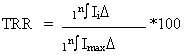
Tab.1
| 1 | Cloud shadow | 8.62 |
| 2 | Wet land | 10.13 |
| 3 | Water | 10.26 |
| 4 | Dense forest | 11.05 |
| 5 | Middle forest | 14.44 |
| 6 | Sparse forest | 16.67 |
| 7 | Bush | 17.32 |
| 8 | Wet agri. Land | 17.32 |
| 9 | Urban | 17.91 |
| 10 | Turbid water | 18.1 |
| 11 | Bare soil | 22.88 |
| 12 | Built-up area | 22.88 |
| 13 | Bare rock | 32.42 |
| 14 | White sand | 38.69 |
| 15 | Cloud | 47.25 |
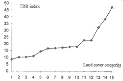
Fig. 1 Graphic presentation of TRR index for land cover categories in the Tab. 1
The value of TRR index theoretically varies from 1 to 100. values of TRR index for some land cover types are shown in Tab. 1 and their graphic presentation is shown on Fig. 1. These values are computed based on ADEOS/AVNIR scene number 1080,160 observed on Apr., 18/1997 of Danang city and surrounding area. As seen on the Tab. 1, could shadow and clear water surface have the lowest value of TRR index. The highest value of TRR index have thick cloud and highly reflected surface such as sand and bare rocky area. Dense forest has the lowest TRR index in comparison with other vegetation cover. However, one fact can be recognized that dynamic range of AVNIR data is actually not so high. Even for highly reflected object like cloud and sand, measured reflectance is only about 50% of sensor sensitivity range design (for 8 bits sensor digital count should be from 0 to 255). On Fig.2 is false color composite and TRR index image of study area.

Fig. 2 False color composite (left) and TRR index image (right)
The TRR index should be used in combination with land cover indicator to provide sufficient classification result. One possibility is to use TRR with NDVI index to support land cover classification. On the Fig.3 is scatter plot of TRR index and NDVI of the study area. The vertical axis is used for TRR index and the horizontal axis is for NDVI. As seen from these scatter plot many land-cover object which has the same NDVI value are located differently in TRR index feature domain. This fact offers potential discrimination of land cover categories of the same NDVI value particularly for those with low NDVI value.
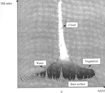
Fig. 3 Scatter plot of TRR index and NDVI. Color shade is generated by standard false color composite of pixel vector
Application Of TRR Index For Land Cover Classification
An algorithm for land cover classification by using TRR index in combination with other image invariant could be proposed as on Fig. 5
Fig. 4
Legent of maps
| NDVI | Maximum likelihood class. | TRR index and other invariant |
| To 127 : water | Water | To 1: water |
| To 150: bare surf. | Cl.Fo.: closed forest | To 50: closed forest |
| To 175:lo w NDVI | Op. Fo.: Open forest | To 51: Open forest |
| To 200:medium NDVI | Bush: Bush land | To 52: Bush land |
| To 255:high NDVI | Grass: Gras land | To 53: Grass land |
| Lang:Settlement in rural area | To 54: Settlement in rural area | |
| Lo. Ve.: Surface with low portion of vegetation To | 55: Surface with low portion of vegetation | |
| Ba. So.:Bare soil | To 62: Bare soil | |
| We. La.: Wet land | To 70: Wet land | |
| To 71: Wetland vegetation (grass) | ||
| Ba.su.: Bare surface | To 80: Bare surface | |
| Cloud: Cloud | To 250: Cloud |
The proposed algorithm has been realized by Microsoft FORTRAN PowerStation 4.0 for Windows 95. Classification by the above algorithm was compared with NDVI and maximum likelihood methods. On Fig. 4a is classified image of study area by level slicing of NDVI image, Fig. 4B shows result of maximum likelihood and the Fig.4C is result of classification and the Fig.4c is result of classification by the above algorithm.
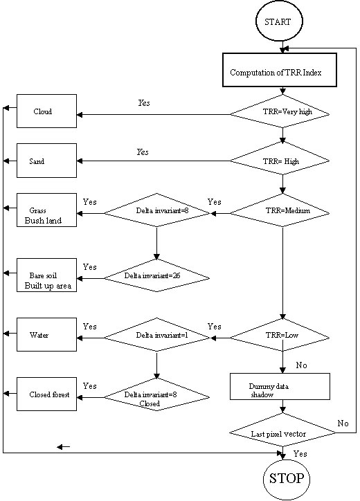
Fig. 5 Computation flowchart of land cover classification by using TRR index
When compare these three classification results we can see that all three methods classify correctly areas with and without vegetation. However, due to impact of topographical and tree canopy shadow the NDVI method shows less accuracy in forest cover classification. Because closed forest has lower NDVI than open forest and bush land so it was classified to class of medium NDVI while open forest was classified to class of high NDVI. By supervised classification and method with TRR index the above inaccurate classification can be avoided. While all land cover categories with low NDVI value are classified into single object in the first classification method, Maximum likelihood method and TRR index method provides finer classification capabilities. The ML method classifies and cover according to how training data was selected. The TRR index method provides the finest abilities to discriminate land cover by combination of TRR index and other image invariant.
Conclusion
The above research result has pointed out a possible way to improve accuracy of land cover classification. The TRR index can be used in combination with NDVI index for fast land cover classification in global and regional scale. When spectral channels of the input data cover both visible and infrared region, it is possible to establish TRR index differently for each spectrum and use them with NDVI index to achieve higher classification accuracy.
Acknowledgment
The author thanks NASDA-ESCAP joint ADEOS research project for the sponsorship to undertake this research. The author expresses also acknowledgement to Fundamental Research Program of Vietnam and Institute for Geography, NCST of Vietnam for supporting this research.
Reference
- David A. Hastings
- Land cover Classification: Some new Technique, New Source Data.
- Proceeding of the 18th Asian conference on Remote Sensing, 20-24 October, 1997 kuala Lumpur, Malaysia
- B.L. Turner II, David Skole, Steven Sanderson, Gunther Fisher,
Louise Fresco and Rik Leemans
- Land-Use and Land-Cover Change, Science/Research Plan
- IGBP Report No. 35, HDP Report No. 7
- Nguyen Dinh Duong
- Semi -Automatic Land cover Classification Using ADEOS/AVNIR Multispectral Data
- Proceedings of the 18th Asian conference on Remote Sensing, 20-24 October, 1997 Kuala Lumpur, Malaysia.