| GISdevelopment.net ---> AARS ---> ACRS 1998 ---> Land Use |
Suitability of Landsat TM and
JERS1 Data in Land Cover/Use Mapping Application
Mardiana shafiee, Noraini
Surip, Noraini lbrahim and ldris Saedin
Abstract A study was undertaken to investigate the suitability of using JERS1 data in complementary with landsat TM data for land cover/use mapping applications, particularly for areas where cloud-free images of landsat TM could not be obtained. Two landsat TM scenes 126/59 and 125/59 dated 22 February 1994 and 26 June 1995 respectively and JERS1 data of 117/297 and 117/298 dated two June 1995 were used for this study area which was located in the south-western region of Johore, Malaysia.
Visual analysis of the HIS image (Landsat TM Bands 4, 5, 3 and replacing intensity with JERS1) showed a very clear separability between pineapple and other types of crops. However, there was no clear boundary separation within the pineapple plots or between oil palm, rubber, horticulture and mangrove . In areas where the Landasat TM image was covered by clouds and shadows which hindered visual classification, the HIS image showed a different colour combination, thus leading to a false visual classification.
1.Introduction
Multi-spectral optical remote sensing data such as landsat and SPOT have been widely used in the management, monitoring and mapping of natural resources. However, the use of such data in tropical regions face a major hurdle due to the inability of the spectral bands of the optical sensors to penetrate through cloud cover. One of the methods to overcome this problem is to use a combination data of different sources (Rosenholm, 1993). By combining data of different sources, areas cloud-covered in one of the image sets are covered by the other. Rosenholm (1993) had successfully used a combination of SPOT and Landsat TM imagery to overcome cloud problem in land use mapping in the tropical areas.
The development of remote sensing technology saw the deployment of synthetic aperture radar (SAR) on orbiting systems such as ERS, JERS and RADARSAT satellite. SAR systems operate within the microwave range of the electromagnetic band which is able to penetrate through cloud covers. Thus, data acquisition of SAR system is more reliable than optical system as it is not affected by weather conditions and acquisition can also be carried out during the nigh. SAR system therefore provides more frequent repetitive coverage than optical system. Nevertheless, the single band nature of SAR data limits its usefulness particularly in identification of land use patterns.
Therefore, it was the aim of this project to investigate the suitability of SAR data to be used in complementary with the optical data for land cover/use mapping purposes.
2.0 Study Area
The study area was located in the south - western region of Johor, Malaysia as shown in Figure 1.

Figure 1: Location of Study Area
The area could be divided into three major types of landscape, namely, coastal plains, undulating low land and hilly to steep higland. In the coastal plains, the land cover/use is predominantly mangrove and horticulture, i.e. mixture of coconut, cocoa and banana. Forest and plantation crops such as rubber, oil palm and pineapple were generally found in the low land to higland arareas. The state of Johor generally has no distinct dry season except in the month of mid October the late November.
3.0 Materials
For this project, JERS-1 SAR data was used in combination with Landsat TM data. The details of these are shown in Table 1.
Table 1: Satellite data used in the study
| Type | Path/Row | Data |
| Landsat TM | 126.59 | 22.02.94 |
| Landsat TM | 125.59 | 26.06.95 |
| JERS -1 | 117/297 | 20.06.95 |
| JERS -1 | 117/298 | 20.06.95 |
Other materials used included 1:50,000 topographic maps.
4.0 Methods
Meridian and Ergo-vista software were used in the processing of landsat TM and JERS-1 data. Due to the limitation of Meridian software in processing 16 bit data, the 16 bit JERS-1 data were first compressed to 8 bit data prior to any processing. A 5x5 Frost filter was used to reduce speckles in the JERS-1 data.
Landsat TM data were geo-referenced to the Malaysian Rectified Skewed Orthomorphic (MRSO) coordinate system and resampled to 12.5 m pixel spacing to match the JERS-1 pixel size. The filter JERS-1 data were then registered to the Landsat TM data using image to image registration technique. A total of 220 control points were selected for this registration.
Landsat TM image of bands 4,5 and 3 on RGB were converted to Intensity-Hue-Saturation image with the Intensity band replaced with JERS-1 data to produce a complementary image. This complementary JERS1- Hue-Saturation image was reconverted to RGB and enhanced to improve visual analysis.
4.0 Results and Discussions
4.1 Image
There types of images were produced for the visual analysis, namely, Landsat TM 453 (ON RGB), single data JERS-1 (panchromatic) and complementary HIS of JERS1-Landsat TM.
4.2 Comparison between images
All three images showed a clear separability between land and large water bodies such as reservoirs. There was also a good separability between pineapple and other types of crops in all the images. In the single data JERS-1 image (plate 2), pineapple area appeared darker the smoother texture than other types of crops. However, different stages of growth of pineapple, indicated by the boundary of pineapple plate could be observed more clearly in the Landsat TM image (Plate 1).
Single data JERS-1 image (Plate 2 and Plate 5) did not show clear discrimination between oil palm, rubber, horticulture, forest and built-up areas. The complementary HIS image (Plate 3 and Plate 6) showed a better discrimination of land cover/use boundaries compared to the single date JERS-1 image (Plate 2 and Plate 5). Nevertheless, there was no marginal improvement in discriminating different land cover/use features between the Landsat TM and complementary HIS images. Similarly, features in areas covered by clouds could not be clearly established from the complementary HIS image (Plate 6)
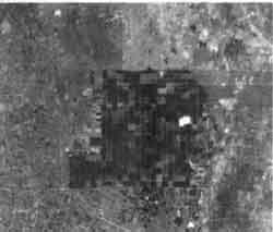
Plate 1: Landsat TM Image (126/59) Bands 453
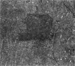
Plate 2: JERS Image (117/297)
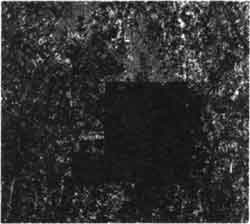
Plate 3: IHS - Landsat TM and JERS
Plate 4: Landsat TM Image (125/59) Bands 453
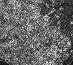
Plate 5: JERS Image (117/298)

Plate 6: IHS - Landsat TM Image JERS
5.0 Conclusions
Visual analysis of single data JERS-1 image could not discriminate the different types of land cover/use features except pineapple. There was no additional advantage that be derived in the complementary use of JERS-1 and Landsat TM data in land cover/use mapping applications.
Bibliographies
- Z.A. Hassan., K.M.N. Ku Ramli, I. Selamat and K.F. Loh. "Complementary Nature of SAR and Optical Data for land Cover/use Mapping", 18th . Asian conference on Remote Sensing, Kuala Lumpur, Malaysia, 20-24 October, 1997.
- Guo Huadong and Zheng Lizhong (editors) "Microwave Remote Sensing for Earth Observation", Science press, China, 1995.