| GISdevelopment.net ---> AARS ---> ACRS 1998 ---> GIS |
Application of Satellite
Imagery and GIS to Wildlife Habitat Suitability Mapping
C. Mongkolsawat and
P.Thirangoon
Computer Center, Kohn Kaen University,
Khon Kaen 40002, Thailand
Tel: 66-43-241031, Fax : 66-43-241216
E-mail: charat@kku.1.ac.th
Abstract Computer Center, Kohn Kaen University,
Khon Kaen 40002, Thailand
Tel: 66-43-241031, Fax : 66-43-241216
E-mail: charat@kku.1.ac.th
An ever decreasing wildlife population is most wildlife sanctuaries of Thailand warrants their habitat study. Identification of potential habitat sites is a prerequisite of possible subsequent protection . this study aims at identifying potential habitat sites for 7 wildlife species in Phusitan Wildlife Sanctuary, the Northeast of Thailand . there are wild Boar, Barking Deer , common Palm Civet, Rhesus Macaue , Golden Jackal , Sunda Pangolin and Sandstone Gecko. These are significant wildlife species of the area, larger species being extinct .
Wildlife habitat suitability study involves an analysis of the complex inter relationship among various environmental factors that exist over a geographical area . habitat suitability model for each of the above wildlife species relevant to Phustan wildlife Sanctuary was identified . each model calls for a study of life requisite factors of food and cover . these factors include forest type , topography , water resource , distance from human activity centers, etc . this study applies each model to GIS in order to identify the most suitable and moderately suitable habitats .
Landsat imagery, field investigation wit GPS and topographic maps were employed to generate and thematic layers relevant to each model in the GIS database , using ARC/info. Overlay operations on these layers leads to generation of habitat suitability maps . field check based on the map out put was conducted and found the agree with the expectation of the model. Estimation of populating size was beyond the scope of the study.
Introduction
In Thailand , the forest area has depleted rapidly form 53 percent of he total land area in 1961 to 25 percent in 1998 ( charuppat 1998) . during the period 1961-1985 the forest area was decreasing at an average rate of 0.5 million has annually. Among the major causes of forest depletion are illegal logging , cultivated area expansion , slash and burn activities. Encroachment on forest Land can not be protected effectively. As a result of the forests clearing , it has had effects not only for surface water hydrology but also has threatened the wildlife habitat as well . to organize plan and project in accordance with the forest land management , a number of national parks , and wildlife sanctuaries were established . the phustian wildlife sanctuary (PWS0 was then established in 1990 with objectives of preventing and conserving and conserving wildlife habitat under strictly legal measures . with an advent of satellite technology and GIS, it is well accepted as tools to establish and to model spatial information . tis paper outlines state of the art satellite data and GIS modeling with a number of wildlife species on habitat suitability data since the technologies applied to wildlife habitat analysis have been reviewed by Epp (1988), Stelfox (1988) , tueller (1980) and Mayer (1984)
The objective of te study is to identify potential habitat sutabiility for 7 wildlife species in the PWS , Northeast Thailand with satellite imagery and GIS analysis . the 7, wildlife species include Wild Boar, Barking Deer, Common Palm, Civet , Rhesus Macaque Jackal , Sunda Pangolin and Sandstone Gecko.
Study Area
The Phusitan wildlife sanctuary covers and area of about 250 km2 and is located in Northeast Thailand . the area is characterized by a diversity of land spaces , land uses as wildlife species . the landscapes comprise the small hill with tropical forest (deciduous and evergreen ) is surrounded by gently undulatind topography of alluvial plain . geologically , the area is underian by a thick sequence of Mesozoic rock and has sporadically rock outcrops . the people in te area are engaged in agriculture and based partly on forest products i.e mushroom, bamboo shoot.
Methodology
The process of identifying wildlife habitat suitability in the PWS is based on its life requisites was reviewed and evaluated ( Aggimarangcee 1992, Davis 1962, Diong 1973 , Grassman 1997, Harriosn 1962 , Lekagul et a 1997 , Sinchareon 1998 and Taylor 1963).
In addition, field investigation was conducted to examine the existing habitat of the defined wildlife species in relevant to their life requisites . the life requisites identified from the this study consists of forest type , topography , water resource and buffer regions within/beyond specified distance of existing human activates center as summarized in the table 1. Each factor are conducted as assigned ad a thematic layer in the GIS . determinate of the various factors are conducted as follows : forest type , water resources , road and tracts were based on Landsat TM acquired on March 1997 and 1:50,000 topographic map. The slope gradient in the area was generated from the 20 m contour lines of 1:50,000 topographic map. Geological formation was provided by 1:250,000 geological map of Department of Mineral Resources . locations of Villages, cultivated area, forest protection units were collected using differential global Positioning System (GPS). Each of the themes with its associated attribute data are digitally encoded in GIS data base . with GIS command , buffer zone with in a given distance of a prespecified set of layer ( roads , village cultivated area and forest protection units ) were generated. As a results , the selection criteria of given thematic layers for wildlife species ( Table 1) were eventually produced.
| Wild Species | Forest type | Slope% | Geological formation | Buffer region | Healthy suitability | ||||
| Water sources (km) | Village(km) | Cultivated Unit (km) | Forest protection Unit (km) | Road (km) | |||||
| Wild Boar | Dry evergreen mixed deciduous |
<20 | - | <0.5 | >1.0 | >1.0 | >0.5 | >0.5 | Highly suitable |
| Dry dipterocarp abandoned land |
Moderately suitable | ||||||||
| Barking Deer | Dry evergreen mixed deciduous |
>10 | - | >0.5 | >2.0 | >0.5 | >0.5 | >0.5 | Highly suitable |
| Dry dipterocarp | Moderately suitable | ||||||||
| Common paim civet | Dry dipterocarp | - | - | - | >2.0 | >0.5 | >0.5 | - | Highly suitable |
| Mixed deciduous | Moderately suitable | ||||||||
| Rhesus macaques | Dry dipterocarp | - | - | - | >2.0 | >0.5 | >0.5 | >0.5 | Highly suitable |
| Mixed deciduous dry evergreen | Moderately suitable | ||||||||
| Golden jackal | Dry dipterocarp | <10 | - | - | >2.0 | >0.5 | >0.5 | - | Highly suitable |
| Dry evergreen mixed deciduous |
Moderately suitable | ||||||||
| Sunda pingolin | Mixed deciduous | - | - | - | >2.0 | >0.5 | >0.5 | - | Highly suitable |
| Dry dipterocarp | Moderately suitable | ||||||||
| Sandstone Gecko | Mixed deciduous Rock outcrop |
- | Phuphan & Phu kradung | - | - | - | - | - | Highly suitable |
| Dry dipterocarp | Moderately suitable | ||||||||
These layer are then spatially overlaid to produce wildlife suitability map. Schematic chart of the spatial overlay for a selected wildlife species ( wild boar ) is illustrated in figure 1.
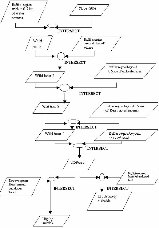
Fig.1 Spatial overlay for wild boar
Result and discussions
Landuse, slope and geology maps generating from into PWS are illustrated in figure 2 (a), 2(b) and 2(c) respectively. The habitat suitability map of 7 wildlife species resulting form the spatial overlay of thematic layers in the PWS is presented in fig 3. the corresponding area for each wildlife species is show in table 2.
| Suitability | Wild Boar | Barking Deer | Common Palm civet | Rhesus Macaque | Golden jackal | Sunda Pangolin | Sandstone Gecko |
| High Moderate Marginal |
4.08 1.48 94.44 |
3.36 1.12 95.52 |
13.16 34.17 52.67 |
74.33 8.16 44.51 |
17.73 6.65 75.62 |
34.17 13.16 52.67 |
2.00 0.98 97.02 |
| Total | 100.00 | 100.00 | 100.00 | 100.00 | 100.00 | 100.00 | 100.00 |
The information obtained provides an approach ot identify habitat suitability for wildlife species. The theme layers to be used in the modeling differ from species to species . the result revealed that the extensive area of the PWS is highly suitable for Rhesus macaque , Sunda Pangolin and Golden Jackal . in the PWS endangered species i.e sandastone outcrop and far from human activities.
This study method identifies the current ability of anta area to provide individual wildlife species with environmental conditions needs for food cover and space. This would reflect existing vegetation cover as influenced by natural and man-caused disturbance .
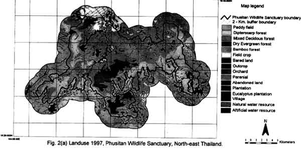
Fig.2 (a) Landuse 1997, Phusitan Wildlife Sanctury, North-east Thailand
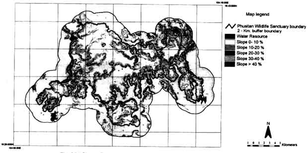
Fig.2 (b) Slope, Phusitan Wildlife Sanctury, North-east Thailand
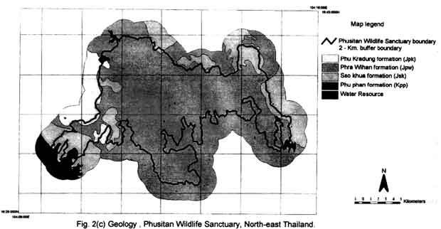
Fig.2 (c) Geology, Phusitan Wildlife Sanctury, North-east Thailand
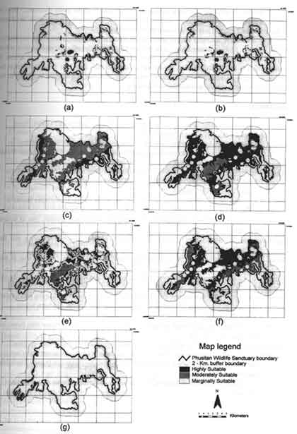
Fig.3 Wildlife habitat suitability map, Phusitan Wildlife Sanctuary, North-east Thailand. (a) Wild Boar (b) Barking Deer (c) Common Palm Civet (d) Rhesus Macaque (e) Golden Jackal (f) Sunda Pangolin (g) Sandstone Gecko
Ground investigation was used t assessed the rreliablility of he model developed . three wildlife species (Rhesus Macaque , sunda Pangolin and Sandstone Gecko) could be directly observed in the field , the rest species were found only their tracts.
In conclusion , for many wildlife species it is possible to evaluation habitat with identification of life requisite and vegetation cover . it is difficult to estimate actual population because animal population fluctuate substantially through time and space . many species are very difficult to observe directly and reliably through survey sample technique . computer based GIS provide the means to model the spatial habitat suitability effectively . accuracy of the model then relies on the knowledge based on wildlife and ecology relationships.
References
- Charuppat T. 1998. forest situation of Thailand in the past 37 years (1961-1998) Forest Research office Royal Forest Department.
- Epp.H., 1988 . application satellite data ad image analysis to wildlife habitat inventory. In Land/wildlife land Classification series No. 22 land conservation Branch, Canada wildlife service. Environment Canada
- Setlfox , H.A., 1988. wildlife resource evaluation and land/wildlife relationship models . in land/wildlife land classification series No. 22 land conservation Branch . Canada wildlife service . environment Canada.
- Mayer. K.E.., 1984. a review of selected remote sensing and compiute technologies applied ot Tueller, P.T. 1980 . Remote sensing application for wildlife habitat management, Univ. of Nevada, Reno. NV.
- Aggimarangsee ,N. 1992. survey for semi-Tame colonies of Macaques in Thailand . Nat. Hist. Bull. Siam soc.40:103-166.
- Davis D.D. 1962. Mammals of the Lowland Raim Forest of North Borneo. Bull .Nat. Mus. St. Sing. 31:1-129
- Doing, C.H. 1973. studies of the Malayan Wild Pig in Perak and Johore. Malay.Nat .Jour . 26(2): 120-151.
- Grassman jr., L.I.1997. Ecology and Behavior of Four Sympatric Carnivore species (Mammalia : carnivora ) in Kaeng krachan National park, Thailand. MS. Thesis. Graduate School, Kasetsart University.
- Harrison , J.L. 1962. the distribution of feedind Habit among Animals lin Tropical Rain Forest. Jour. Anim. Eco .31:53-64.
- Lekagul , B and McNeely. 1977. mammals of Thailand. Kurusapha Ladprao Press. Bangkok.
- Simchareon , S. 1998. Home Range of and Habitat Uses by Male Asiatic Jackal, canis aureus at Khao Nang wildlife Research Centre, Thailand. Wildlife Research Division, Royal Forest Department, Bangkok.
- Taylor, E.H. 1963. the Lizards of Thailand. The University of Kansas Science Bulletin . 44 (14): 791-796