| GISdevelopment.net ---> AARS ---> ACRS 1998 ---> GIS |
Development of a
Internet/Distributed Image Database System for Multi-sensor and
Multi-source Imagery/Raster Data
Takahiro Endo*, Shiro
Ochi**, Mitsuhiro Tokunaga**, Royosuke Shibasaki*
*Center for Spatial Information Science,
**Institute of Industrial Science
University of Tokyo
7-22-1, Rappogi , Mnato-Ku, Tokyo 106-8558, Japan
Tel :+81-3479-2762, fax . +81-3-3408-8268
E-mail: endo@skl.iis.u.-tokyo.ac.jp
Abstract *Center for Spatial Information Science,
**Institute of Industrial Science
University of Tokyo
7-22-1, Rappogi , Mnato-Ku, Tokyo 106-8558, Japan
Tel :+81-3479-2762, fax . +81-3-3408-8268
E-mail: endo@skl.iis.u.-tokyo.ac.jp
In recent times , a variety of imagery/raster database have become available, such as space-borne sensory data, aerial photographs, digital evaluation model data and land-use data. Hence, as datasets distributive are managed by each many researchers and organization , it has been quite difficult to search data a satisfying specific for use's requirements such as location , time , resolution and so forth. The authors are developing a distributed database system which allows users to retrieve data from a distributed ftp sites across the internet.
This paper describes overview of the database system . the database system will be used for searching Landsat TM and other of SE Asia an support of land-use mapping project .
1. Introduction
At present time, as lots of remote sensing satellites have been launched all over the world, resulting in researchers using many space-borne datasets, aerial photographs and DEM . in addition to using such images, it is also possible to additional data like geographic information as GIS. Further, recently sensor resolutions are on the rise and also have multi-spectral bands. Thus resulting in large volumes of data of such sensors and its acquisition becoming expensive. Hence the author considers that if and image database system that manages many spatial metadata and images existed, the system would be advantageous for lots of researchers. For example, the system could reduce the time that it takes of researchers to search datasets needed.
The author has developed the image database system that is able to manage some spatial datasets and run a service that user can simultaneously find out the availability of remotely sensed data of the given location from different sensors like Land sat TM and others.
2. System Overview
2.1 Hardware and software components our system is running as a Client -server-system.
Fig. 1. Shows the composition of the system of database.
- Hardware
- DB Server : DEC Prioris MT 6200
(CPU Pentium Pro 200 MHz, RAM 64 MB , HDD 3.6GB) - FTP Server :SUN Ultra-1
(CPU Ultra-sparc 167MHz, RAM 128MB, HDD 45 GB)
- DB Server : DEC Prioris MT 6200
- Software
- OS : Windows NT server 4.0, Solaris 2.5
- DBMS : File Maker PRO 4.0
- Web Brower: Internet Explore 4.0 and Netscape communicator 4.0
- Language :CGI (perl 5.003 for win 32 and JAVA Script )
- Sample Database
- Landsat TM (7 bands =: 1 band =5305 MB , CD-ROM, SE Asia area )
- Landsat MSS ( 4 band : 1 band =14.2 MB , CD-ROM, SE Asia area
- DEM (1 km)
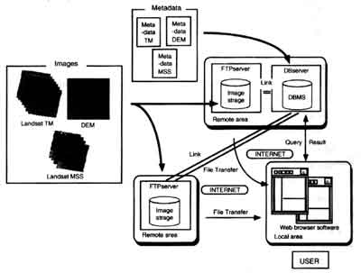
Fig. 1 System Configuration
2.2 characteristic of the system
- uses can simultaneously find out different sensed data with the given location. The retrieve system on this database is based on a representation of satellite image/raster data and a retrieve method. The representation of satellite image/raster data and a retrieve method. The representation of satellite image/raster data is represented with a latitude/longitude coordinate of four corners of satellite image and of convex of raster data. The retrieve method used a rectangular envelope with the coordinate of convex.
- As our system is can e used over the currently available WWW browse software such as Internet Explore or Netscape communicator, users don't need any special software. The data retrieval system is independent of the OS of the user's machine
- The load on the sever is at a low level, because this server manages only metadata as text strings and images are managed by a file server system on other machines.
- The administrators of this system are able to manage the database on remotely over t network. Hence, when researchers are going to supply database , they can access the database at anywhere places.
The logical structure of metadata consists of eight major groups such as ID information, Data content , Space range character, Radiometric correction character, platform/sensor character, Time, Quality and Reference .the fig .2 shows the theoretical structure of metadata for our system.
The above described structure of metadata cab deal with both metadata's of satellite data and of raster data like DEM. By the way the coordinate system of our system is latitude/longitude coordinate system before it is input into our database. The format of time in our metadata fields is Greenwich mean time (GMT) we choose this format to allow for input of data form all the different sources an counties. The fields used in retrieval system are sensor name , acquisition data, latitude /longitude of corners or path/row information . In our system the format of path /row isn't WRS of Landsat 1,2,3 but that of WRS of Landsat 4,5.
|
| ||||||||||||
| |||||||||||||
Fig .2 Logical structure of metadata
4. Data management in the system
The physical structure of metadata of our system is based on the structure of the relational database systems . Because of the following three reasons-firstly, our database have ot manage a lot of images; secondly , to update or delete image/raster data is very easy on Internet ; and finally, the advantages I being able to extend this structure into database system of t future . hence, we used the relational database structure . fig .3 stands for the update of image/raster data.
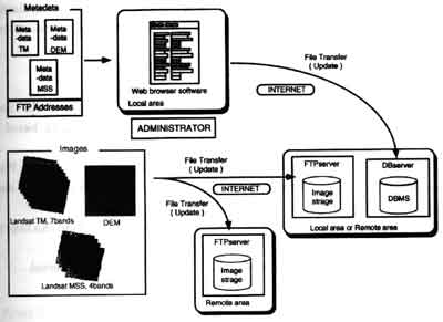
Fig.3 Update of Image/Raster data
In addition, when images are stored into a database, there are two methods of managing the images within the database structure. Te first methods is that a field of the database stores images onto itself, the other method is hat the field of the database only stores the text string containing the absolutely path of storage of image data. The former method can manage both metadata's and images in one database , but, as the volume of satellite imagery is so large in size , that a large proportion of the database is consumed by the satellite image data. Therefore it is difficult to maintain and to renew a database. Further in this method only one server must process both the functions of retrieval and download , which may cause the load of network around server to go up. These problems are the demerits of this approach .
The late method is better than the former method in some points . a database doesn't become large, as the later method only deals with text sting . therefore the management of database is very simple . moreover , the load of network around server is avoided being too high, because the other file transfers sever deals with the process of download.
Our system can renew both metadata's and images on internet, if the user is his physical distance from the main system. That is to say that lots of researchers can administer the database, if they have the requisite permissions . therefore, as management of database on our system is the management of distributing style, an administrator' work is share and all researchers as datasets supplier cab participate in our system.
5. conclusion
- we have developed the image database system in which the user can simultaneously find the availability of different sensed data based on the user's given location .
- Our system is independent of the operation system such as Windows, Macintosh and other as we use the features supported by t commonly used web browser software's
- A lot of researchers as datasets supplier who are at anywhere can take part in this system for using internet.
- The management of database of our system is available on Internet
- we will improve our database system in order to use others datasets of lots of sensors and vector datasets.
- We will combine our database system with application such as automosaicing software .
- We will develop and application that automatically can input a metadata into an image database system .
- Japan Association on Remote Sensing : Remote Sensing Note, Japan Association on Remote Sensing ,1996
- ISO/TC 211: Geographic information/Geomantic, ISO/TC 211 Secretariat, 1998
- Toshifumi Masunaga: Foundation of Relational Database ( in Japanese ), Ohmsha 1990
- Laure Lemay: A guide of HTML ( in Japanese ). TOPPAN Printing Co. Ltd., 1996.
- Ryosuke Shibasaki: Introduction of Geographic Information System ( in Japanese ), Japan Association of Surveyors, 1995.