| GISdevelopment.net ---> AARS ---> ACRS 1998 ---> GIS |
Recreation Zoning Management
at Taroko National Park using a Self -developed Spatial Information
System
Pei -Wang Lin*, Yueh-Land
Liao**
Superintendent*, Deputy Superintendent**
Taroko National Park
291 Fu-Su Village , Hualian , Taiwan, R.O.C,
Tel: 886-3-8621100 Fax: 886-3-8621083
E-mail: tnpifo@ms10.hinet.net
Abstract Superintendent*, Deputy Superintendent**
Taroko National Park
291 Fu-Su Village , Hualian , Taiwan, R.O.C,
Tel: 886-3-8621100 Fax: 886-3-8621083
E-mail: tnpifo@ms10.hinet.net
Taroko National Park is one of the six national parks in Taiwasn pursuing objectives of conservation , recreation, research , and environmental education . it covers an area of 92,000 hectares and its visitors are more than 1.2 million s every year. Recreation zoning management at he national park has to pursue the four management objectives simultaneously. In the last here years, a self -developed spatial information system was made to manage all recreation areas at the national park. Remote sensing technique was implemented to make aerial photos and orthophotomaps of all recreation areas in digital form and can be extracted for further analysis on a color monitor . topographic maps and site maps of every recreation are at a scale e of 1:1000 were built into the database and can be overland with the existing maps in the database such as zoning maps, contour maps, compartment maps, topographic maps , and so on . every land parcel in the recreation areas was classified according to its zoning and land use category by the self-developed spatial information system . recreation zoning management now can be performed on a single land parcel basis as well as a given land use category . recreation zoning management cab be performed either form attribute inquiry or map inquiry. All functions provided by the system cab be displayed on web pages . recreation zoning management at Taroko National Park now can take advantage of emote sensing and spatial information systems.
Introduction
Taroko National Park has an area of 92,000 hectares. It consists of 162 sheets of orthophoto map at a scale of 1:5000. it is more than a showcase of geology. its scenery is not only beautiful but also outstanding. it attracts more than 1.2 millions of visitors annually. the eastern-western-cross island highway goes through the national park a very tough task. private land parcels scatter along he highways long before the birth of the national park. public resorts and private recreation facilities are subject to restrict land use regulations after the establishment to the national park. recreation zoning management of Taroko National Park has to pursue the four objectives, say conservation, recreation, research, and environmental education simultaneously.
In the last three year, a self -developed spatial information system was made to manage all recreating sited at the national park. Remote sensing technique was implemented to create raster type databases such as satellite imagery, orthophoto maps , aerial , aerial photograph, and traditional photos. Vector type database consist of topographioc maps , site mps at a scale of 1:1000, the zoning map of the national park , cadastral maps . attribute of every single recreation site map as well as a single private land parcel has to be created inte o the databases. Attribute of every private land parcel has to be classified into certain land use type according to the zoning map of the national park. Every private or public land parcel has to meet the requirement of recreation zoning code of the national park . land use certification cab be issued on a daily management basis with some query on a personal computer. Zoning and land use type of every single land parcel can be decided either from map inquiry or attribute inquiry.
The objective of this paper is trying to discuss how recreation zoning management at Tarko National Park can be facilitated by a self-developed spatial information system and remote sensing.
A Self -developed Spatial Information System
A self-developed spatial information system for the recreation zoning management at Taroko National Park consists of hardware , software , and databases. Its computer operating system cab be windows 98 or NT Chinese editions . only personal computers and its peripheral are required . hardware is quite simple such as personal computer with color monitor , mouse pointing device and printer, either laser or ink-jet is fine . software was written in PASCAL that is the major computer language comes with Delphi 3.0 Because of the rapid and integrated development package provided by Delphi 3.0, computer programming is not a time consuming and labor-intensive task . data manipulation, input and output , display, inquiry, map overlay , zoom-in and zoom-out , pan , and map layer on or off re functions provided by the spatial information system. User friendly s the most important ingredient of the spatial information system . the most difficult part is the creation of databases . topographic maps , recreation site as , cadastral maps , and zoning maps are the four major types of the maps to be overlay with one another r. attribute of a single land parcel has toe be classified into its zoning land use type and to be built into the databases as new data fields . an inquiry on a personal computer of a given land parcel only requires typing its parcel number and clicking the right land section by computer pointing device , mouse. Raster map files have been created in different file formats such as BMP , GIF, and FIF. Vector map files re created in DWG format as well as text type file format. Attribute is stored in DBF and text type file formats.
Problem Associated with Recreation Zoning Management
Land use certificcaiton for a given lad parcel has to be issued based on a written request as soon as possible. Four types of maps have to be overlay in the first place such as the zoning map, a cadastral map, recreation site map, and topographic maps. Different scales and different coordinate system of the four type maps maps make a manual overlay process quite difficult and inaccurate. A wrong assignment of a given land parcel may create large problems to the management of the national park , even lawsuit . all land use certification have been issued need to be built into the databases for further manipulation . according to the recreation site plan , a give land parcel should be classified into the more specific and use types such s hotel resort , parking lot , camping site , and so on . illegal land use practice on a recreation site can be monitored closely.
Recreation Zoning Management by A Spatial Information System
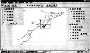
Figure 1. the Taroko National Park Zoning map overlay with cadastral maps.
Figure 1 indicated the at Taroko National Park zoning map overlay wit cadastral maps on a color monitor. Land use type inquiry is process of zoom in , zoom-out , and pan process. Typical type of recreation zoning management cab be shown on figure 2. figure 2 shows after a given land lparcel number was typed and the right land section has been chosen then all required information , maps and attributed, are ready for inspection and a portion of maps can be printed on a color printer right away. Figure 2 indicates a land parcel has been categorized as a scenic zone . then, land use certification can be issued using Microsoft Word 97.
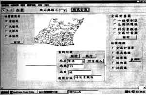
Figure 2. inquiry for a given land parcel shows all required information .
Conclusion
Recreation zoning management at Taroko National Park was usually a process of labor intensive and time consuming . now, with the help of a self-developed spatial information system it is easy and simple for the process of issuing a land use certification. This self -developed spatial information system is not trying to sole all management problems at once. Remote sensing technique has been implemented to facilitate database creation and its potential on recreation zoning management is worth while for further research. Although the self-developed spatial information system is user friendly and efficient for recreation zoning management at Taroko National Park, it is necessary to create more function to solve problems encounter on daily management at Tarokio National Park in the near future.
References
- Banner , D.A. 1998. learn Graphic file Programming with Delphi 3. Wordware Publishing, Inc. 422 pages.
- Chrisman, N. 1997. Exploring Information System. John Wiley & sons, Inc. 298 pages.
- Henderson , K. 1996. Database Developer's Guide with Delphi 2. SAMS Publishing/ Borland Press. 857 pages.
- Swan, T.1996. Delphi 32-Bit Programming Secrets. IDG Books. 738 pages.
- Thuroff , P. et al. 1997. Delphi 3 Supper Bible. Waite Group Press. 11312 pages.