| GISdevelopment.net ---> AARS ---> ACRS 1998 ---> GIS |
Development of Traffic
Accident Information System using Geographic Information System (GIS)
Noriel Christopher
C.Tiglaco
National Center for Transportation Studies
University of the Philippines
Diliman , 1101 Quezon City, Philippines
Tel (632) 929-0495 Fax : (632) 929-5664
E-mail: noriel@ncts.engg.upd.edu.ph
Abstract National Center for Transportation Studies
University of the Philippines
Diliman , 1101 Quezon City, Philippines
Tel (632) 929-0495 Fax : (632) 929-5664
E-mail: noriel@ncts.engg.upd.edu.ph
Traffic safety plays as key and integral role in a sustainable transportation development strategy. The main negative impact of modern road transportation systems today is injury and loss of life as a result of road accidents. The success of traffic safety and highway improvement programs hinges on the analysis of accurate and reliable traffic accident data. This study discuses the present state of traffic accident information in Metro manila . it shall also discuss the potentials of developing a traffic accidents information system using geographic information system (GIS) . initial attempts on the integration of geo-referenced traffic accidents data for spatial analysis shall be discussed . lastly, this paper comes up with some recommendations on the institutionalization of such a system line Metro Manila.
Introduction
There is no doubt that traffic safety has emerged as one of the key problems confronting contemporary Philippine urban society . although this is so, it has to been given much attention and remains uncharted mainly because the more pressing problems such as traffic congestion are at hand.
While of the road accident situation is slowly improving in the high income industrialized countries, most developing countries such as he Philippines, face a worsening situation . the continuous socio-economic growth over the years is causing increasing demand fore transport service including road transport . with the number of vehicles on the road growing rapidly, more road conflicts develop vis-à-vis traffic accidents .
Most of these accidents result from human error and carelessness on the part of the derivers or pedestrians . However , the probability of occurrence, and its severity , can often be reduced by the application of proper traffic control devices, and good roadway design features . the success or failure of such control devices and design specifications however , depends extensively upon the analysis of traffic accident records at specific locations. It has long been recognized that the most effective means towards accident reduction lies in a systematic and scientific approach based on the use of accurate and reliable traffic accident data . but the quantity of data important for the analysis are not always sufficient
Much of the accident information available in police files is all too often incomplete and therefore has not been utilized to the fullest extent. In addition, records are also needed to provide facts to guide programs including enforcement, education, maintenance, vehicle inspection, emergency medical services, and engineering to improve streets and highways.
Much of the accident information available in police files is all too often incomplete and therefore has not been utilized to the fullest extent. In addition , records are also needed to provide facts to guide programs including enforcement, education , maintained , vehicle inspection, emergency medical services, and engineering to improve streets and highways.
There is a need for better information of the circumstance of collisions , especially with regards to location in order to come up with a general picture of the data. More precise location data could help provide facts to guide programs including enforcement, education , maintenance, vehicle inspection , emergency medical services, and engineering to improve streets and highways .
Accident record keeping has to been give much priority by concerned government agencies . so far , there is no integrated database that accounts for accidents statistics for the whole country .
Key Stakeholder in Traffic Accident Information
At the helm of traffic accidents data investigation and reporting is the Traffic Management command (TMC) of the Philippine National Police . by virtue of a Standard Operation Procedure (SOP) adopted by ht police organization, all traffic accident report forms filed at the different districts ail over the country should be submitted to the TMC Headquarters at Camp Crame, Quezon City. In metro Manila , the operation and management of the PNP is divided into five (5) distinct districts, namely: North , South, East, West and Central . Directly under the District Commander is the Chief of the Traffic Division. The Additionally, the Traffic Management Group (TMG) has sole jurisdiction along the stretch of EDSA.
The Traffic Accident Investigation Report Program started in 1978 under the Traffic Studies of the Ingra structure Planning Research and Statistics Division (IPRSD0 of the Department of Public Works and Highways . specifically , the Traffic Studies Section encodes the TAIR and furnishes the Bureau of Design , Maintenance Division and the Philippine National Police (PNP) in Crame of the encoded reports/statistics. The data gathered by the Traffic studies Section are used for planning and improvement of road design and safety.
Apart from the DPWH-T4affic Studies section and the PNP, the Metropolitan Development authority (MMDA) also perform an important role in Traffic Accident Investigation Report . MMDA serves as the mediator between traffic accident victims and the PNP traffic investigator
The safety Organization of the Philippines (SOPI) is a non-government organization which also aims to contribute in the traffic accident concern. SOPI conducts training on the following :1) Better Driving Course- which covers road safety , road accidents, common traffic violations safe driving, emergency driving and trouble shooting ; and 2) Land Transport Fleet Management which covers road safety , road accidents, fleet safety program, accident investigation and analysis , terminal and garage safety .
The Traffic Engineering Center (TEC) maintains operational data on major intersection . it also maintains the traffic signal control system for the Metro Manila Area. It collects and summarized traffic accidents form all police districts. Its does this by fielding personnel who will collate the data.
Almost recently , the TEC embarked on a project for the utilization of a GIS-based system for traffic accidents. However , the system could not be maintained . the TEC Library contains a good collection of accident information on paper . so far , no database system is in place. The TEC also suffers from perennial organizational problems.
The National Center for Transportation Studies ( formerly Transport Training Center ) is a regular unit of the University of the Philippines System. The NCTS plays a leading role in human resource development ad research activities in the field of transportation . NCTS conducts transportation research with the general aim of improving the country's transportation system . it continues to provide transport professionals from government with better education and training services .
Current State of Traffic Accident information
The authority responsible for nation wide accident record keeping is the Traffic Management Group (TMG) of the Philippine National Police (PNP). Accident records form all PNP Police Stations are to submit to the TMG Districts or Teams stationed in each region. These reports are then transmitted for consolidation to the TMG office in camp Crame. A committee under the chairmanship of the Department of Public Works and Highways (DPWH).
At present, the system of traffic accident investigation and reporting is plagued with organizational and technical problems. These include incomplete data on e TAIR, non-submission of traffic district to the TMG Hq, discontinuity of program due to change in officials; and inconsistency of forms used by the different police stations.
Currently, there is an information gap with regards traffic accident date due to the following reasons . first, the currant traffic accidents database system is ineffective due to non-submission of forms . a second reason is the inaccuracy and inefficiency in the actual traffic accident investigation and reporting . a last reason would be the absence of a comprehensive traffic safety and highway improvement program.
Development of a Traffic Accident Information system
The development of an integrated traffic accident information system is prompted . organizational restructuring wit focus management has to be adopted by government in order to delineate and relegate certain function which are integral to the overall system . recent developments in computer technologies can be utilized in order to aid manual work in the work of traffic accident data warehousing.
Figure 1 shows that network configuration for the proposed Traffic Accident Information System . in this proposed system , several remote sites shall be connected in a Wide Area Network (WAN). A cost-effective netwoek connection can be established using dial-up network protocols. Remote sites include the five traffic management districts in Metro Manila and PNCC for the North and South Expressway data.
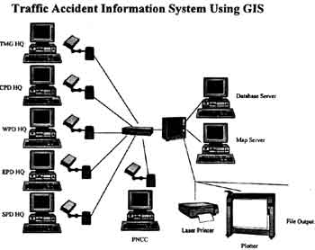
Figure 1. Network Configuration
A central site shall maintain the database and map server. Te central sit shall also be equipped with plotting and external storage devices for achieving purposes.
In such a system, information from the traffic accident investigation report forms are directly encoded via an interface program. The application shall be constructed under a Client/server Architecture as shown in figure 2. reporting police stations shall only need to forward their reports to the district office for proper processing and input. Thus , accident reports can be updated on a daily or weekly basis to prevent backlog. The system shall also update the master database at the central site. The central site, on the other hand , shall prepare accident' black spots' and data processing and report preparation for the whole coverage area .
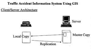
Figure 2. Applications Architecture
Geo- referenced Traffic Accident Data
Presently, the existing TAIR forms considers the following referencing system : a ) XY Map Number , b) X and Y-coordinates, Route Number, KM station, 100m Station, Nope Map number, and Node Numbers. However, the aforementioned systems have not been utilized. This sis due to the fact that there has not been and overall authoritative system that is in place yet.
The current referencing system adopted the TAIR are non-earth based references. Although, not fully implemented the TMG HQ are set toe encode accident locations manually. Thus there is a big backlog of accident records that has yet to referenced. Te problem is even made more complication by the non-submission and incomplete forms. A further constraint is that the km-post system only cover national roads.
Relevant work at the Department of Public Works and Highways sere on-going through the Road Information and management support System (RIMMS) Project . the RIMMS Project hopes to create the ground work for a Location Referencing system (LRS) that will cover the entire country.
Central to the system is the utilization of GIS technology. Utilization of such a cost-effective technology offers big potential fro information delivery. The use of GIS would ease the work of geo-referencing accident data. Proper and accurate spot maps can be established. Moreover, accident data can be tied with other spatial data such as road characteristic and intersection geometry, to cover a full - range of analysis
Areas of Improvement
Several areas of improvement are identified as requisites for an efficient traffic accident information system., as follows:
- Better traffic accident investigation procedure ( eg. Accident site measurements, reconstruction ),
- adherence to the official Traffic Accident Investigation Report (TAIR) from
- creation of an integrated traffic accident database system ,
- geo-referencing of accident occurrences
- utilization of available cost-effective technologies ( eg. Geographic Information System, Global positioning System),
- utilization of Client/server network architecture for better information delivery, and
- training and education of traffic accident invest gars in the field of accident investigation and reconstruction .
the benefits and potential of the creation a traffic accident information system is great. It is implement able and realistic, only concerned government agencies, research institution , as well as , the private sector should participate in an overall program for traffic safety. Cost-effective technologies like GIS can be utilized to provide a reliable system.
Recommendations
The research is still in the initial stage . several initial and general recommendation, however, are put forth as follows :
- strengthen institutional organization and link-ups towards the efficient collection, reporting and monitoring of road traffic accidents.
- strengthen training activities for accident investigation and reporting.
- employ cost-effective and innovative solutions t traffic accident data reporting and monitoring, such as geographic Information systems .
- establish better accident investigation standards and reference system .
References
- Coordinating consultants (1994), Philippine National Police Traffic Accident Report from Manual of Instruction and Examples, IBRD Assisted Highways management Project Road Safety Component, November 1994 .
- Research Meetings with Traffic Accident Section, DPWH and RIMMS Project .