| GISdevelopment.net ---> AARS ---> ACRS 1998 ---> Geology/Geomorphology |
Processing of Landsat TM
Digital Data for Sand Dunes Source Studies in Central Iran
R. Ajalloeian, H. R. Pakzad
and M. A. Mackizadeh
Department of Geology, Faculty of Sciences
University of Isfahan, Isfahan 81744, Islamic Republic of Iran
AbstractDepartment of Geology, Faculty of Sciences
University of Isfahan, Isfahan 81744, Islamic Republic of Iran
Studied are nearby 2500 square kilometer is located 167 Km, south east of Isfahan. General geological formation and unit are as: Cenozoic volcanic rocks (In north and east of area). Mesozoic sedimentary rock (South and west of area) and quaternary sediment in the west of area.
As a result of quaternary geological aspect and acting, sand dunes were formed as erg in the area around 173.75 square kilometers. Movements of these sand dunes are always threating for urban and and agricultural area. In this regard this is necessary to study distribution and sources of the sand dunes. This studies has been done by using of Remote Sensing technique. It is provided one scene of digital data of landsat satellite for studied area. These data are in TM bands.
Interpretation of digital data has been done with two special softwares for processing (IDRISI) and Er. Mapper in geological department of Isfahan University. Various techniques such as color composit, stretching, filtering and P. C. A. for processing are used. Finally, thematic maps in following regard are produced.
- Distribution of huge and erg.
- Outcrops of various lithology that are present in the area,
- Discrimination of quaternary deposits includes: playa, river and delta sediments,
Introduction
Studied area is located between Longitudes of 52°, 44 and 52°, 59 and Latitudes of between 32°, and 32°, 20. This area nearby 2500 square kilometers is located 167 Km of south east of Isfahan. From the point of view of zonation of Iran (2), this area is located at sanandaj sirjan zone along Zagros thrust and volcanic belt of central Iran (Fig 1). This depression is called Gavkhuni that include of lake and terrains around the lake.
Geology of area
The lithology of the basin consist of sandstones and shals and cretaceous limestonis. These rocks are located at west and north-east of area. The lithology of east-north east of area are mainly volcanic and Pyroclastic rocks that belong to Eocen Period. The neogen rocks inlclude of red deposits of molase in north-west of Lake and also pyroxene andesits in the north of area (3). Quaternary depoeits Consist of alluvial, fluvial, Lake deltaeic and eolian sands. At the present time, evaporite (salt and gypsum) and detrital sediments (clay and sand) are forming in lake and around of lake. Eolizn sands are extended from verzaneh to Jarghoieh (west of Gavkhuni lake). The morphology of province these sand dunes are mostly barchan and star dunes. Generally, the same dunes can be considered as a gian erg extended from north-east to south-west (Fig. 2) (1.3).
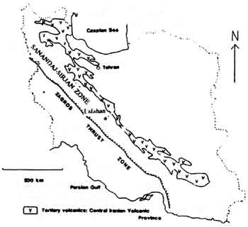
Fig. 1. Position of Studies area in relation to Geological units of Iran (after shahabpour, 1987).
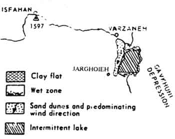
Fig. 2. Main units of Gavkhuni Depression (after crinsly 1970). (4)
Study of eolian sands origin
To survey the origin of eolian sands, It has to be considered the sedimentary basins which has role in creation of sands. In present paper, the studies has been concentrated on satellite digital data accompany with field work and laboratory study to distinguish and separate the geological units.
Remote sensing studies
For this study digital data (TMS) with path number 168 and row number 37 and 38 has been used. This digital data involve geological map of Isfahan, nain, Abadeh. All of image processing has been done by IDRISI and Er. Mapper softwares. At first 6 bands of 7 bands from TM data are mixed together. These bands are in range of vision wavelength to near thermal infrared wavelengths. Finally some processed colour composite (RGB) was made. In addition, for further discriminations, other techniques are used.
- Colour composite has been stretched (RGB, 741) by Er. Mapper (Fig.
3). This is stretched by autoclip transform with histogram. The high
pass filter is used for better enhancement. In this picture san dunes
borders are well defined in west and north-west of lake. Other features
which is distinctable are as follows:
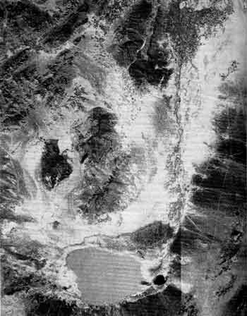
Fig. 3.
- Vegetation area is defined by green colour
- In north of lake the deltaic sediments, marginal mud flats are in black and special brown colours respectively
- Neogen volcanic complexes includes pyroxene andesite decites andesite-basalt are shown by light gray to dark gray colours.
Also individual hills in north east of lake with purple colour showing rhyodacitic tertiary volcanics. Especially Mesozoic limestones in this area are shown by light brown in limited NW-NE extent.- Generally, the fans in north west, north, north east and east of lake are distinct dark blue colour, this feature shows magmatic source of fan components.
- Mesosoic shales, sandstones and carbon formations re defined by violet and light-dark brown colours. These formation are outcropped in west of area and their related fans are also have the same colours.
On the base of this colour composit interpretation we can conclude that there is two distinct divisions in basin:- Cenozoic magmatism rocks and related fans:
- Mesozoic sedimentary rocks and related fans.
- True colour composite has been made (RGB 321) which is stretched by
linear method and is filtered by a general filter (Fig 4). In this image
we can see only the water content of the lake (white colour) the
residual terrains in lake area are salty-clay flat. This image was
prepared by IDRISI software.
Fig. 4.
- The RGB 741 colour composite is also made by IDRISI software (Fig
5). This image is prepared by using two external filter and changes in
saturation, hue and lightness as follows:
Hue = -3 saturation = -45 lightness = -3
This image such as the first one shows total features of the basin. The diversity of geological units which are discriminate are:- Lower cretaceous sediments.
- Quaternary sediments in the western and eastern parts of area.
- Salt and mud flat around the lake.
The metamorphic rock fragments such as schist, genies, metagranit has been found in river and deltaeic sediment sample and also in sand dune which they wer brought from the north-west of Isfahan at the beginning of Zayandehrod basin.
The igneous rock fragments such as andesite and basalt has been observed in the all of sediments (Sand dune-river-alluvial sediments). The source of these fragments are north-western part of studies area. In the view point of sedimentary rocks, the composition of grains is mostly carbonate particles which has been originated from the south-western part of area.
Conclusion
According to these study (image processing, field work and laboratory research), the origin of eolian sand is mostly medium grained sediments(sand size) that belong to Zayandehrod delta and sand plain that located in the western of sand dune.
In the view point of precision and time saving, it is necessary to mentioned that the useful of image processing (in this study ) was very helpful.
References
- Shahrabi, M (1994), Sea and lakes of Iran. Geological survey of Iran.
- Shahabpour J. et al (1987), Lead isotrope date from the sar-cheshmeh porphyry. Cooper deposit, Iran Mineral. Dc posita, 22 pp 278-281.
- Zahedi, M. (1976) Explain of Isfahan geological map. Scale (1/250000). Report No.8 (f8). Geological Survey of Iran.
- Krinsly D. B. (1970). A geomorphological and paleoclimatological study of the playas of Iran, Washington. D. C.