| GISdevelopment.net ---> AARS ---> ACRS 1998 ---> Geology/Geomorphology |
Gold exploration in
North-East golpayagan area using Landsat TM data
Tabatabaei S. M.: Sharifi
M.; GhaziFard A.; Haddadi, R.
Geology Dept. Isfahan University; Isfahan; IRAN
AbstractGeology Dept. Isfahan University; Isfahan; IRAN
In the study area, gold containing rocks are formed in an alternation complex of Barrowian Type (medium temperature and pressure). The area had been under polymetramorphism (dynamothermal, contact, dynamic, and hydrothermal metamorphism).
Since the later metramorphism were weaker than the earlier ones, the older rocks were under more intense metamorphism such as sericitization and chloritization.
By using remotely sensed data, faults and discontinuities of the area specially the alternation zones were studies and gold containing rocks were identified. The studied were also correlated with field, Petrography and geochemical studied. By using these techniques, now locations of gold mineralization were identified.
Gold containing rocks in the area are of subalkaline and calc-alkaline types, different petrological diagrams shows that, the responsible magmas or gold mineralization are of bimodal, one is basic tholeitic magma and the other one is acid calc-alkaline magma, and in between, there is no intermediate series.
The Mutch gold mine in this are is considered as a model which gold is mostly present in metarhyollite, meta-dacite to high potassium meta-andesite. Generally, gold is found inside fractures and lattice structures of pyrite and also within altered fractures and zones. Mineralogical studies of gold containing rocks of the area show that, the minerals which are observed in the altered zones are quartz plagioclase, K-feldspar, albite chlorite, epidote, mica, carbonate, rotileand pyrite.
Introduction
Study site is located in west of Muteh mine, Isfahan province in Iran (Fig. 1 ….). The petrological , Lithostratigraphical and paleontological studies on metamorphosed series in Golpaygan, Muteh area which is located within the Sanandej-Sirijan belt indicated that, this area was under influence of Early Paleozoic movements.
Along the schistosity, specially within fractures, faults and joints metallic minerals such as pyrit and chalcopyrit have been observed.
Regarding gold mineralization (genesis), according to Farhangi (1991) it could be imagined that mineralization of pyrit and gold were formed simultaneously by under water (submarian) acidic volcanic activities, acidic magmatization and alternative sedimentation. In other words, magmatic rocks beneath the area contained gold minerals and whenever the magma penetrated, whether in the form of intrusive acidic veinlet rocks into the structure, gold would scatter in the pyrit or chalchopyrite mineralization inside the rocks.
Geologic setting
Study area covers some 1200 KM2 in east of Khomeyn and situated in Sanadaj-Sirijan metamorphic belt. From geological point of view. Formations of Muteh-Golpayegan region belong to Precamberian (Thielte et. al. 1968, stocklin , G., 1977, Farhangi, A. 1991), but recent studies based on conodonts and Achritage (Baltisphfaeridium) suggest that these formation belongs to Paleozoic (Sharifi, M. 1997) and rejected the idea of previous researchers.
Susseptibility of these rocks or Au concentration makes it more interesting for exploration in Muteh auriferous deposit.
In Muteh mining district, Au concentrated are in fractures of metahyolite rocks. The extension of these metarhylite rocks extend toward Khomin region. Evidences of pyrite in this region attact interest for more investigation. Along the schistosily, specially withing fractures, faults, and joints, metallic minerals such as pyrite and chalcopyrite bearing gold grains and whenever the magma penetrate it appear in the form of acidic volcanic or in the form of intrusive acidic veinlet rocks in to the rock mass, and gold has been scattered in the pyrite or chalcopyrite mineralization inside the rocks (Fig. 2, 3).
Field Surveys
The climate of khomin region is arid to semi arid and vegetation is relatively skarse on the mountains. The study are is widely covered with phyllite, Quartzite, chloriteschist, garnet mica schst, gneisis, and amphibolite. Some instrusive bodies have intruded in to garnet mica shist and metarhyollite. Mineralization modeling (Paidar, 1989) in Muteh mine are as follows:
- mineralization is correlate with tectonic, metamorphic and hydrothermal activeties
- Ores are deposited in fractures.
- The form of ores follows the form of vein and veilets.
- Wall rocks have undergone the alteration.
- Pyrite is the most abundant and the important gold-bearing mineral based on the field observations this modeling along with investigations and evidences showed that, pyritization in this region is ratherly extensive and mostly is concentrated in veinlets and in someplace disseminated in the rocks. Hydrothermal fluids originated from intrusive bodies and after going through the cracks and fractures zones if deposited auriferous pyrite in metahyolite. A landsat TM subscene consisting 640 lines with 1200 pixel chosen from a quarter scene, were selected for detailed enhancement (fig. 4). Different rock units were recognized by enhancing satellit digital data.
Mtarhyolites and Metadacites In these rocks major rocks forming minerals are quartz and foldspers, and accessory minerals and serisite, chlorite, biotite, muscovite, sphene zircon, opac and calcite, the grain size is fine to intermediate and porphiric plagioclase and secondary quartz made by silisification are larger. Silicification and chloritization can be seen in thin section. Carbonatizition is observed in some rocks specially in veinlets.
In this region, mineralogy of gold containing rocks are very simple and containing biotite and muscovite which are originated from metamorphic processes and quartz and feldspars originated from igneous sources.
Alteration Zones
In the study area in vicinity of gold containing veins, the silification, seritization and chlorotization following alternation processes can be distinguished.
The thickness of the alternation zones varies from one meter to tens of meters. Alternation processes leaves iron oxid staines on sulfined bearings ores in the area. Mixture of iron oxid and clay minerals affect spectral reflectanes in satellite processed images.
On the other hand, in chlorotization biotite changes to chlorites and releases Fe2+ as the following reactions:
2K(Mg,Fe)3(AlSi3O10)(OH,Fe)2+4H+ +2H2S
4FeS2+4H2O+14O2
4FeSO4+2H2SO4+O2
2Fe(SO4)3+6H2O
4FeS2+15O2+8H2O
Image Processing Data
The possible technique for litholigic discrimination using land sat TM data with the visible and short-wavelenght-infrared (SWIR) were examined.
The importance of the short-wavelength-infrared (SWAIR) range (1.3-2.5um) has been stressed in geologic remote sensing since Hunt (1977, 1979) proposed its potential. A false color composite image of bands 7,4,2 and 5,3,1 was useful for visual interpretation to distinguish lighologic boundaries and vegetation.
In image composed of RGB 742, the metarhyolite can be seen as red purple, grantic bodies in pale brown.
Different image processing techniques were used for image enhancement and lithologic discrimination such as stretching, filtering, and principal component analysis. In the created images some different rock units were recognized. More over, structural tilting of Haji Qara (1341 m. height) with NE-SW trend can be distinguished. This mountain range is the extend of Muteh Geologic structure and metamorphic units. This range is separated by a bended fault from Cretacious limestone, marls, and shales and also Eocene volcanics in north of area.
Band Ratio : one of the simplest image processing techniques is Band Raio an image with 3/2 can highlight the iron oxide (Fe3+) (fig.5). 7/5=R 5/4= G 3/2= B
Acknowledgement
The authors wish to thank the head of deputy of research dept., Dr. Enshaei R., for supporting this research project financially.
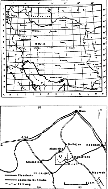
Fig 1 Location of study area
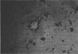
Fig 2 Picture of Gold as inclusion within Pyrite from Chah-khaton Gold mine (x576.PPL)
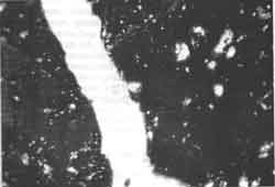
Fig 3 Picture of Gold mineral inside a Pyrite fracture from Chahkhaton Gold mine (576.XPL)
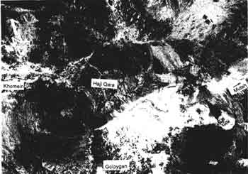
Fig 4 Picture RGB 742 from North-East of Khomei Area
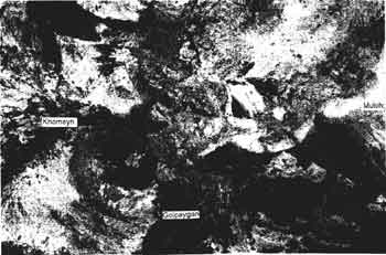
Fig 5 Picture RGB (7/5=R 5/4=G 3/2=B) from North-East of Khomein Area.