| GISdevelopment.net ---> AARS ---> ACRS 1998 ---> Geology/Geomorphology |
Volcanic Geomorphic Hazards
Research In Southeast Asia
Jan J. Nossin
Div. Applied Geomorphology, ITC, Enschede, the Netherlands
The geomorphic consequence of volcanic
events constitute hazards of a specific kind, arising out of the
emplacement of new material which is ten subjected to the 'normal' exogene
processes acting in the area. Div. Applied Geomorphology, ITC, Enschede, the Netherlands
Large volumes of Pyroclastic Flow deposits in the summit zone of a volcano, usually at considerable altitude, constitute the source material for mass movements causing, volcanic mudflows and debris flows, known as lahars. Lahars initially find their way through existing drainage channels, which soon depending on local circumstances- get clogged, and avulsion causes lateral spread outside the streambed. If unchecked, large areas are affected in the downstream reach, giving rise to the build-up of fluvio-volcanic (piedmont) fans. The erosive, transportive and destructive powers of lahars are enomorous, and checking them is a difficult undertaking.
At the same time, the recognition of such fans from past events, constitutes a tool in the analysis and zonation of the hazard.
The suddenness of event is a major hazard; the bed of the deposition zone reaches an elevation above the surrounding terrain especially in cases where dikes are constructed to retain the lahar deposits within the floodplain realm. When such a lateral dike give way, the surrounding terrain downstream of the breach is in grave danger.
The pre-eruption drainage system, also the sectors outside the actual lahar deposition zone, is affected by channel blocking and shifting, which may cause unexpected floods. Mobilization of ash deposits has a similar effect.
In this paper, and attempt is made at synthesizing the studies on hazard zonation and risk assessment as a consequence of these events, in the Philippines and in Indonesia.
In the Philippines, studies on lahars from the Pinatubo (eruption in 1991) have been undertaken by staff from several Philippine institutions,(Phivolcs, Mines and Geosciences Bureau, Public Works Department) together with ITC staff. The includes study of erosion in the source area, and the monitoring of lahar deposition over the years studied on these aspects. Satellite imagery and GIS have played a substantial role in these studies. In Indonesia, volcanic-geomorphic hazard studies have been undertaken in the Sunda-Tangkuban Perahu area (West Java), Mt Gede (West Java), Mt. Agung (Bali), and Merapi (Central Java), along with morpho-tectonic and geochloronological studies in the Sunda area. This paper does not claim to give full coverage of all the work done; although geomorphic-volcanic hazard studies and hazards zonation are still in their infancy, some beginnings have been made.
In the following, studies in the Santo Tomas River basin on west Luzon, Philippines, will be treated in some more detail.
Three SPOT XS images are the basis for this study: one image from before the Pinatubo eruption (April 1988), one just after it (December 1991), and one four years later (April 1995). They are shown in figures 1, 2 and 3 respectively; the original false color composites are replaced, for the sake for reproduction, by Band 2. Further materials available include air photo coverage from before and after the eruption, a TM image of early 1992 and two more SPOT P images of 1995. Radar imagery was not used in these studies; reference is made to Lopez et al, 1996.
The geomorphology of the basin was first studied by Javelosa (1985), who found significant geomorphic anomalies in the area, like an uplifted coastline, blocked rivermouths, wrapped and ruptured river terraces and drainage anomalies. At that time, it was barely known that the Pinatubo was an active volcano.
The June 1991 eruption gave an answer to many of the lingering questions but at the comparative study on lahar deposition in the basin was done by Calomarde (1997).
The source material for the lahars is the Pyroclastic flow deposits in the upper an middle Marvella basin. This fault-controlled river joins with the Mapanuepe river at right angles to form the Santo Tomas river. The lahar masses blocked the bed of the Mapanuepe river, to form the Santo Tomas river. The lahar masses blocked the bed of the Mapanuepe river, and a sizeable lake of course filled again and presently (1998) it is maintained at a manageable level by a controlled artificial outlet.
It is significant to note that it is now clear that the whole plain from the Pamatawan river in the south to the northern rimming hills north of the Santo Tomas river, has its likely origin in the infilling of a (tectonic) embayment mainly with (reworked) lahar deposits from previous eruptions. From the junction of the Marella and Mapaneupe rivers, the Santo Tomas river deposits indicate an originally southwesterly course, confining the Pamatawan river to the south fringe of the plain. This river also shows active entrenchment, indicating uplift of the area. The Santo Tomas river is then forced northward, probably by its own lahar deposits. The coast shows an uplift of about 6 meters, which tends to block the deposits in the plain and hinder the drainage which often is barely or not at all able to reach the sea.
The eruption has created havoc in this relatively sparsely populated area; most of the damage was by roof collapse under the weight of wet volcanic ash, mostly of medium sand size. The lahars started coming down even during the eruption, rupturing whatever dikes existed along the south bank of the Santo Tomas river in numerous places, threatening Castillejos and flowing through San Narciso. In each following monsoon/typhoon season, more lahar material was carried down, and initial efforts to clear out the debouchure and construct dikes, were wiped out by the force of the new lahars. Until concrete-lined dikes, were built that held, especially north of Castillejos. The 1995 image shows clearly how the lahar deposits are retained by the south dike, and in the north and San Rafael in the south are completely drowned in the lahar deposits. Calomarde (1997) calculated and measured the thickness of the lahar deposits of 1991 (fig. 4) and 1995 (fig. 5). These figures also show the impressive lateral growth of the lahar 'repository' in the mid-course of the Santo Tomas river.
The maximum thickness in the central part in 1991 was 9-20 meters, in 1995 it was over 40 meters. As the supply of new lahar material is not nearly finished, this poses a new threat: the dikes now hold but the basin outside fills up, and clearing out of the deposits by the Santo Tomas River is minimal with respect to the new supply. So he dikes can be expected to rupture with increasing lahar deposition, or , more likely, simply be overtopped. In that case, they will be undercut from the landward side; a lahar flow 'in the back' of the dike is a hazard not to be underestimated. Continuous vigilance, heightening and strengthening of the dike is essential. A more detailed publication on this area is in preparation.
The following is a listing of studies undertaken in the context of the MSc programme at ITC, Enschede, the Netherlands (one is a PhD thesis), dealing with volcanic-geomorphic hazard identification, monitoring, and zonation.
Philippines:
Atienza, G. Jayne T., 1995, Lahar Mapping Using Remotes Sensing and GIS Techniques- a Case Study of Pasig-Potrero River Basin, Mt. Pinatubo, Phillippines. ITC, M. Sc thesis. [includes volcanic history of Mt. Pinatubo, lahar change detection, Pasig Portero basin, radar imagery].
Calomarde, RolandoI., 1997, Lahar: an Attribute of Change in the morphology of Sto Tomas-Marella River, Mt. Pinatubo, Zambales, Luzon, Phillippines, ITC, M. Sc thesis. [includes eruptive history, lahar change detection by remote sensing; lahar extent, distribution, thickness in Marella-Sto Tomas basin; Mapanuepene lake; shoreline changes]
Daag. Arturo S., 1994, Geomorphic Development and Erosion of the Mt. Pinatubo 1991 pyroclastic flows in the Sacobia watershed, Phillippines. ITC M. Sc thesis. [measures and models erosion and removal of the PF deposits in upper Sacobian basin as lahar source material; relates to rainfall]
Daag, Arturo, and van Western, Cees J., 1996 . Cartographic Modelling of erosion in Pyroclastic flow deposits of Mount Pinatubo, Philippines; ITC Journal 1996-2, p. 110-124.
Dayao, Arlene A., 1994, Morphostructure and Hazard Implications in Mt. Mayon, Phillippineds, a GIS-Assisted Volcanic Hazards Study. ITC M. Sc thesis . [includes eruptive history of Mt. Mayon, products, processes and hazard implications, factors affecting distribution of volcanic products and hazards, hazard susceptibility mapping].
Javalosa, Ricarte S., 1986, Morphogenesis and Neotectonism of the Santo Tomas Plain, Southwestern Zambales, Luzon, Philippines. ITC M. Sc thesis. [Morpho-structural study of the Sto Tomas basin that was later profoundly affected by the 1991 Pinatubo eruption]
Javelosa, Ricarte S., 1994, Active Quaternary Environments in the Philippine Mobile Belt. Ph. D Thesis, ITC Publication No. 20, ISBN 90-6164-086-5, 179 p. [includes chapters on Sto Tomas basin, neotectonism, geomorphic instability related to Pinatubo eruption, risk assessment].
Nossin, Jan J. and Javelosa, Ricarte S., 1996, Geomorphic Risk Zonation Related to June 1991 Eruptions of Mt. Pinatubo, Luzon, Phillippines; in : O. Slaymaker (ed.), Geomorphic Hazards, chapter 6, pages 69-94. John Wiley & Sons. [includes composite risk zonation index, based on geomorphic mapping, geomorphic risk analysis, georesource priority and site-specific input]. A general and comprehensive account of the Pinatubo eruption of 1991 is : Newhall, Christopher G. and Punongbayan, Raymundo S., (eds.), 1996, Fire and Mud, Eruption and Lahars of Mount Pinatubo, Philippines, Univ. of Washington Press, Seattle & London, 1126 pgs. [complete record of the 1991 Pinatubo eruption; sections and papers on human impact, history, geophysics, volatile emissions, observations and reconstructions of eruptions 1991-92]
The use of SAR data is reported in : Lopez E., et al, 1996, Mount Pinatubo Lahar Damage Assessment usingERS-1 Synthetic Aperture Radar Data; Proc. UN-IAF workshop, Education and Awareness, Space Technology Appl. In the Developing World; UN Office Outer Space Aff. Vienna.
In Indonesia volcanic-geomorphic hazards studies have been undertaken in the context of the ITC MSc programme in the Sunda-Tangkuban Perahu area (West Java), Mt Gede (West Java), Mt. Agung (Bali), along with morpho-tectonic and geochronological studies. A PhD study at the Universite Blaise Pascal, Clermont Ferrand, France, deals in depth with the lahars at Mt. Merapi (Central Java); another paper with lahars of the Kelud volcano.
Noor, Dijauharry 1992. The Applications of Aerospace Imagery to the Study of Morphostructural Landforms and Volcanism in the Sunda Volcanic Complex, West Java, Indonesia, ITC M. Sc thesis [includes classification of volcanic landforms, neotectonism, synthesis of tectonism and volcanism in the surroundings of Mt. Tangkuban Perahu, north of Bandung].
Bacharuddin Rudy, 1990. Geomorpholigical Approach to Volcanic Hazard Zonation, using remote Sensing Images; two case studies from Indonesia: Mt. Gede, West Java, and Mt. Agung, Bali. ITC M. Sc. Thesis. [includes hazardous volcanic products and events, volc. Hazards in Indonesisa, hazard zoning for Gede (West Java) and Agung (Bali) volcanoes].
Lavigen, Franck, 1998 Les Lahars du volcan Merapi, Java central, Indonesie. These de Doctorate, Univ. Blaise Pascal, Clermont Ferrand, 538 pgs + annexes. [geomorphology and risk associated with lahars of Merapi volcano; study and monitoring of triggering mechanism and flow processes on the SW and south flanks, surveillance and warming systems; with extensive (31 pages) bibliography].
Thouret, J.-C., K. E. Abdurachman, J. -L. Bourdier, S. Bronto, 1998, Origin, characteristics and behaviour of lahars following the 1990 eruption of Kelud volcano, estern Java, (Indonesia); Bull. Volcanol. V. 59, p. 460-480.
Two further titles, important in this context:
Kusumadinata, K., Ed, 1979, Data Dasar Gunungapi Indonesia, Volcanological Survey of Indonesia, 820 p. [catalogue of references on Indonesian volcanoes with eruptions in historical time; extensive bibliographies, covering all volcanological publications in Indonesia upto 1979].
Some related studies on volcanic geomorphology and chronology:
Dam, M. A. C., Suparan P., Nossin, Jan. J., Voskull, R. P. G. A. and GTL Group, 1996. A chronology for gemorphological developments in the greater Bandung area, West Java, Indonesia. Journ. Of Southest Asian Earth Sciences, vol. 14, Nos. ½, p. 101-115.
Dam. M. A. C., 1994, The Late Quaternary Evolution of the Bandung Basin, West Java, Indonesia. Doctor's Thesis Vrije Universiteit Amsterdam, 252 pags. [dates the basin sediments and reconstructs the Bandung Lake's lifespan. Includes dating]
Nossin. Jan J., Voskuil, Robert P. G. A. and Dam, Rien M. C., 1996, Geomorphologic development of the Sunda volcanic complex, west Java, Indonesia. ITC Journal 1996-2, p. 157-165. [eruptive sequence of the Sunda volcano, predecessor of Tangkuban Perahu, dated by relating the deposits to datable sediments in the former Bandung lake].
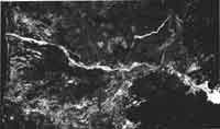
Fig. 1 Santo Tomas basin (Luzon, Philippines) April 1988 (SPOT Band 2)
Simkin, Tom and Fiske, Rischard S., 1983, Krakatau 1883, the volcanic eruption and its efforts, Smithsonia Institution Press, Washington DC, 464 p. [100 years after the eruption, a detailed account and recapitulation of the eruption which produced an estimated 18 km3 of erupted material, an eruptive cloud reaching an estimated 50 km high, and a devastating tsunami; it claimed over 36.000 lives]
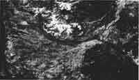
Fig 2 Santa Tomas basin Dec. 1991 (SPOT Bd 2)
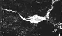
Fig 3 Santa Tomas basin April 1995 (SPOT Bd 2)