| GISdevelopment.net ---> AARS ---> ACRS 1998 ---> Forest/Resources |
Geomantics in Emergency
Planning and Management :Canadian Forest Fire management Experience
Dr. P.
Chagarlamudi
Geomatics Canada ,
Department of Natural resources 615 Booht Street,
Ottawa, Ontario, Canada KIA 0E9
E-mail: pchagarl@nrcan.gc.ca
Geomatics Canada ,
Department of Natural resources 615 Booht Street,
Ottawa, Ontario, Canada KIA 0E9
E-mail: pchagarl@nrcan.gc.ca
Abstract
Emergency planners and managers are routinely confronted with a maze of complex decisions that require reliable information extracted from accurate and often current spatial data. Emergency management is a comprehensive system set up by governments, private sector agencies and individual to address natural and human -indicated hazards. Prevention, Preparedness, Response and Recovery programs are the four parts or components of this system. Canada, like other countries, has as obligation to protect its peoples and the environment from hazards.
Geomatics is an information technology sector focusing on the acquistion, storage, analysis, dissemomaton and management of geographically referenced information. . geomantic Canada, the principal mapping agency of the government of Canada, maintains in its databases a variety of geographic information that is critical in responding to a majority of emergencies. Global Positioning systems (GPS) and remote sensing are some of the newer sources for creating the spatial data layers that can be manipulated using a geographic information systems system (GIS) to aid in decision making.
The significance of the spatial databases and the utility of geomantic technologies to efficient emergency management are presented through the Canadian wildland Information System developed by Natural Resources Canada. Particular focus is placed on integrating remote sensing data products with a GIS to provide managers with new tools to enhance support in planning and managing emergency operations.
Introduction
All governments have an obligation to protect their peoples and the environment from hazards.Its geography, demography , social systems and institutions, political system and foreign policy dictated the manner in which emergency management is conducted and organized in a country. Natural and human-induced hazards such as earthquakes, floods and forest fires, kill thousands of people and destroy billions of dollars of property each year. Thimely and accurate geographic information is essential for carrying out rescue, relief and rehabilitation efforts thus minimizing effects of these hazards 1.
The Government of Canada ha identified about 60 types of emergencies that might affect Canadians2. they range from forest fires, large floods, transportation and industrial accidents to severe earthquakes. Cooperation among government and other organizations and people is s trademark of Canada's emergency planning and management practice. Three levels of government-local, provincial and federal-cooperate and share resources and information in this practice, although the responsibility ofr meeting emergency situation rests with the level of government most directly affected. Each of the three levels of governments maintains spatial information relevant to management operation in the geographic region of its jurisdiction. The national mapping agency, Geomatics Canada, provides geographic information covering the Canadian landmass
Emergency Planning and Management in The Canadian Context
Canada is a vest landmass. Living within the ten million square kilometers of sovereign territory, comprising virtually every geological and ecological features found on the earth, are roughly 29 million people. The great diversity of Canadian geography, environment and economic activity contribute to a variety of potential threats that must be considered within the emergency spectrum. Emergency preparedness Canada, a deferral government organization, plays a key role in the development and maintenance of an appropriate level of civil emergency preparedness across Canada.
Canada's emergency management is based on the following principles2. first it is up to the individual to know what to do in an emergency. If the individual is unable to cope, the different orders of government are needed. Local emergency response organizations are normally the first on the scene. If they are overwhelmed, they may seek assistance from the province or territory, which in turn, will ask the federal government for help if necessary. In practice, emergency response management is based upon an active and cooperative partnership between all levels of government, public and private organizations, and the population at large. Emergency management in Canada is comprehensive system set up to address natural and human induced hazards and has four parts or programs: Prevention, Preparedness, Response and Recovery.
Geomaticsgeomatics5geomatics
Improved emergency planning and management is a concern as well as priority in Canada and in many other countries. It involves several aspects ranging from monitoring, risk assessment and planning to copying with an event and evaluation its consequences. Decision making in emergency management requires reliable information extracted from accurate and current spatial data . this is precisely where geomantic technologies, encompassing the business of geographic or spatial information management, come in to play.
Geomantic may be defined as the science ad technologies involved in management of geographically referenced information, including its acquisition, storage , analysis and dissemination. Geomatics is an "umbrella term" which has been adopted in Canada to encompass the disciplines of surveying, mapping, hydrographic surveys and nautical charting, cartography, remote sensing, and geographic information system (GIS) including associated systems, products and services.
Geographic Information on Canada's Landmass
Geomatiacs Canada is the national agency responsible for surveying, mapping, remote sensing and GIS in the Canadian federal government. It maintains and provides a variety of geographic information products on Canada's landmass for use in emergency management application3.Specific categories of products include aeronautical charts, cadastral surveys, geodetic survey, remote sensing data, thematic maps and topographic information. These are available both as digital and conventional products except for the products of the geodetic survey which are in digital domain. These data are crucial both for assisting the emergency services to make assessments about resources that they need to deploy in such events and for high quality estimates to be made of risk
Geodetic survey products Geodetic Survey Products Survey Product5 geodetic Survey Products.
The geodetic survey products are required for precise positioning, tracking and navigation. Specific products routinely supplied consist of vertical and Horizontal Control Networks Products, Canadian Active Control System (CACS) observational Data, GPS Satellite Clock Corrections , and Precise GPS Satellite Ephemerides3.
Topographic Information
Products on topographic information consist of the National Topographic Database (NTDB). The Canadian Road Network (CRN) the Canadian Elevation Data (CDED) and the Digital Terrain Elevation Data (DTED)3.
- NTDB covers the entire Canadian landmass and contains the features normally found on topographic maps at the scale of 1:50,000 and 1:250,000.
- CRN is the name of the national digital information base of Canada's road infrastructure. Extracting and reclassifying road infrastructure data from the NTDB created the CRN
- CDED consists of an ordered array of ground elevations at regularly spaced intervals. It is based on NTS maps at the 1:250,000 scale.
- Geomatics canada's DTED constitute a uniform, continuous matrix of altimetric data. However canadian coverage of DTED is incomplete
Satellite and airborne imagery covering the Canadian landmass are available from the center for Remote (CCRS)3. These include ERS-1 canadian Images, AVHRR Canadian Images, Sample Synthetic Aperture Radar (SAR) Data, SPOT PLA/MLA, Landsat MSS/TM, MOS MESSR, MSR & VTIR, ERS-1 SAR, JERS-1, NAA AVHRR, Airborne C/X SAR, Airborne Data and SEASAT SAR. With RADARSAT's launch on Nov. 4, 1995, Canada and the world now have access to the first radar satellite system capable of large scale production and timely delivery of data.
A private corporation, RADARSAR International, Inc. (RSI), was established in 1989 to process, market and distribute RADAESAR data to Canadian commercial users and to international users. In cooperation with CCRS and the Canadian Space Agency, RSI will help research and develop commercial applications, and will negotiate foreign reception and distribution agreements for RADERSAT data.
Canada's Fire Management Systems
Forest fires are a regular and serious concern in Canada. Ad an example, during the 1970-1995 period, the number of forest fires in Canada ranged from about 6,000 to 12000 a year. Roughly half of the fires were caused by human activities while the remaining were attributed to lightning or unknown causes. The area burned varied from a low of 0.4 million hectares in 1978 to a high of almost 8 million hectares in 1990 amounting to $275 million, respectively in fire fighting costs 4.
There are 417.6 million hectares of forestland in Canada. The forest sector and forest resources are vitally important to Canada, in terms of their contribution both to the national economy and to the environment. Condition want relevant, timely, and authoritative information about the state of their national resource. Geomatics technologies and products are employed in the data acquisition and in managing the forest resource including fires.
Canadian Wildland Fire Information system (CWFIS)
The CEFIS, developed by National Resources Canada, is an example of a hazard-specific national system. The system automatically accesses observed and forecast national weather data, uses a GIS to transform the data into spatial information on probable fore danger and fire behavior, displays the information as national maps, and disseminates the maps through the World Wide Web. The system's database incorporates underlying terrain, fuel, and elevation maps. The goal here is "to develop information and decision- support system to monitor and predict wildland fire activity in Canada and to enhance fire management efficiency and effectiveness"5. the program consists of four major component:-
- National monitoring and forecasting reports on fire weather , behavior, serverity, and on fire management Criteria and Indicators.
- Decision support tools and models for fire occurrence prediction, resource allocation, mesoscale fire weather forecasting, and landscape level fire simulations.
- Long-term five growth models using probability and climatology
- Collaboration in the development of a national fire economic analysis system. The CWFIS provide tools to personnel responsible for fire control and suppression. Theses tools range from simple charts and nomograms to sophisticated computer programs and physical models. GIS can combine fuel (vegetation ) , terrain and weather data needed to run fire growth models . long-term fire growth can be predicted using probability and climatology.
The FWI system is a tool developed in the CWFIS. It consists of six components that amount for the effects of fuel moisture and wind on fire behavior (Fig .1). the first three components are fuel moisture codes (FFMC, DMC, and DC) and are numerical ratings of the moisture content of litter and other fine fuel the average moisture content of deep, compact organic layers. The remaining three component are fire behavior indexes (ISI, BUI, and FWI) which represent the rate of fire spread, the fuel available for combustion, and the frontal fire intensity; their values rise as the fire danger increases.
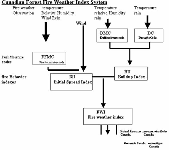
Fig.1. Components of the Canadian Forest Fire Weather Index System
The FWI is suitable as a general index of fire danger throughout the forested areas of Canada. Figure 2 shows the map of the Fire Weather Index of Canada on August 5, 1995 as disseminated through the World Wide Web. During the 1998 season, forest fire activity in Canada has been sever with more than 10,000 occurrences and burnt area of 4.4 million hectares as of September. The season's fire occurrence and at the 5th highest and the seasonal area burned at the sixth highest in the past 25 years.
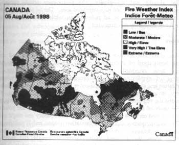
Fig.2. Map of the Fire Weather Index for Canada on August 5,1998.
Remarks
Fire management system provided tools that help fire control an suppression. These systems are based on geomantic technologies and information. Geographic Canada maintains and privies geographic information products on Canada's landmass for use in forest fire and other emergency planning and management systems. The CWFIS is the only operational automated GIS-based national wildland fire information system in the world. It facilitates the interagency transfer of fire suppression resources; supports agency-level fie management decisions; and provides the government, fie management agencies, the media and the general public with a comprehensive national picture of the forest fire environment.
Emergency management has received particular attention in Canada during the past couple of years, in part, as a result of severe flooding in the Province of Mnitobe and the 1998 Ice Storm in the Provinces of Ontario and Quebec. Disaster management is also an important part of Canada's long Term Space Plan (LTSP) III, currently under consideration to address the next generation of space applications.
References
- GARTELL, A.C. and Vincent. 1991. managing natural and Technological Hazards. In Handling Geographic Information: methodology and Potential Applications. (Ed) Masser, I. And M. Blackemore. Longman Scientific and Technical , England.
- Emergency preparedness Canada, 1997. internet site. http://hoshic.cic.sfu.ca/epc/en-home.html.
- Geomantic Canada , 1997. internet site http://www.geocan.nrcan.gc.ca/.
- Gomlpendium of Canadian Forestry Statistics: national Forestry Database. Natural Resources Canada. 1997
- Canadian forestry service, 1998. internet site. http://www.NRCan.gc.ca/cfs.