| GISdevelopment.net ---> AARS ---> ACRS 1998 ---> Forest/Resources |
Applied Landsat-5 TM and
Vector Data through Computerized Techniques in Developing Forest Maps and
Forest Cover Maps at Thung- Saliam District, Sukhothai Province,
Thailand.
Manasanan kantontong
Geographician (cartographer )
Forest Resource Analysis Division, forest Research Office
Royal Forest Department, Bankok 10900,
Thailand .
AbstractGeographician (cartographer )
Forest Resource Analysis Division, forest Research Office
Royal Forest Department, Bankok 10900,
Thailand .
A study on the classification of forest types, landuse patterns and human activities was conducted at Thung- saliam District, Sukhotai province in northern Thailand. The purpose of the study is to produce a forest map, a forest cover map and a 3-dimensioal view (3-D perspective view ) of the forest cover of Thung-Saliam District by using Landsat5-TM imagery (FCC) and the computer compatible tap (CCT. Tape ) containing Lansat 5-TM data. By using a CCT. Tape, data interpreted from Landsat 5-TM imagery and visual interpretation, data collected from the study area were processed and analyzed by the special program naming EASI/ PACE version 6.2.2 incorporated with SOLARIS 3.5.1 operating system. The method applied in the study is based on a supervised and an unsupervised system of Maximum Likelihood Algorithm and overlay analytical techniques which were employed to solve conditions as required. The final outcome indicated that using the supervised together with the unsupervised systems would give one specific best result apparently identifying the Landsat -5 TM data into 8 categories: water body, paddy field, cropland, heterogeneous orchard with natural stand, completely destroyed mixed with degraded forest, dry dipterocarps forest, mixed deciduous forest and other areas. The result after overlaying a forest cover map on the DEM was a 3-D perspective view of forest cover information of Thung-Saliam District. The forest cover map and 3-D perspective view techniques.
Introduction
Thailand has been endowed with rich forest resources. In 1950 s, over half of the entire kingdom has been covered with forests of heterogeneous types. Timbers and non-forest produces were superfluous. Timbers were among the principal natural resources of exporting commodities which earned great amount of incomes annually and the played a significant role in developing this country of many decades . unfortunately, these natural resources have been exploited and depleted rapidly in the last few decades particularly forest. Due to population pressure associated with rapid expansion of agricultural lands, forest areas decreased down drastically . extensive pieces of forest lands have been cleared and converted into crop fields and other used. Some forest parts of the country with moderate slope have been disturbed beyond recognition: big forest have been fragment in to small patches scattering all over the country. This destructive human activity continued uninterrupted annually. Forest covers decreased down to merely 25% of country area nowadays.
In order to monitor an catch up with the forest area changing new forest survey and mapping technology viz., Landsat imagery technology has been introduced into the service of the Royal Forest Department (RFD) to substitute the out of date ground survey in 1973. data from various satellite have been obtained via the Natural Research Council of Thailand which has data receiving station of its own.
Nevertheless, mapping surveying technology of natural resources including forests have been developed rapidly in the last few decades and computerized technique is very effective, reliable, and expeditious at present. As mentioned earlier, to catch up with the ever-changing of forest areas of the country the computerized techniques ie., sun Ultra-1 workstation with soft wares EASI/PACE (version 6.2.2) has been used by the RFD in 1988. data obtained from some existing satellites such as Landsat MSS, Landsat TM, spot, Mos-1 and JERS-1 can be obtained expeditiously through this programme. Many information can be obtained expeditiously through this programme. In order to familiarize with this technique, application of newly introduced forest mapping has been done at Thung- Saliam district in Sukhothai province .
Objective
This study has the following objectives.
- Assessing the existing forest lands in study areas, 1.e, Thung- Saliam district by district by using Landsat-5 TM imagery, CCT. Tape accompanied with ground check.
- studying vegetation distribution , forest type, and human disturbance in study area.
- evaluating the limitation of the Landsat -TM imagery (FCC) and Landsat 5-TM digital data (CCT. tape ) in identifying the existing forests, forest types disturbed areas etc.
- try out the functional feasibility and effects of the sun Ultra-1 workstation with operating system spares 3.3.1 and software EASI/PACE package version 6.2. for forest classification and overlay analytical techniques for the following purpose.
- identifying and differentiating forest covers, forest types, level of disturbances
- generating the digital Elevalion Model (DEM) and 3-D perspective view of study area and
- installing raw and classified data in the database.
Thung-Saliam district in Sukhothai province is a district in nrhtern part of Thailand locating between latitudes 17°33' 19.19" N-17° 33' 23.31" N and lontitudes 99° 22' 37.08" E-99° 46' 21.94" with total area of 456 sq. km.
Topography and Geology
Topographically , Thung-Saliam district is characterized by fault block basin which being type topography of the northern part of Thailand. The area which is laying on the upper north of Piitsanulok Kamphaengphet basin consists of 2 features of topography-alluvium plain in the east and mountainous area in the west. The area underlain by meta-sediment and sedimentary rooks partly volcano pyroclastic rocks of late ploeozoic to early Mesozoic ages.
The rocks in Thung-Saliam area can be catagoried into the following types.
The oldest units, namely Don chai Group consist of quartzite, phyllite, schist sandstone, fuff. Limestone lens of low grade metamorphic to sedimentary rocks, Silurian-Devonian in age. This rocks unit forms small hill and low mountain range laying on the eastern part of the area.
The carboniferous sedimentary rock, mae Tha Group composes of sandstone, shale chert and conglomerate overlain on the Don Chai Group.
Thung-Saliam Formations, mainly, limestone bedded to thick bed well laminated and recrytalline in texture, form the karst topography which is characterized the area this until interpreted to be Permo Carboniferous in age.
The Triassic Sedimentary rock, Hong Hoi formation, cover the western part of the area where the topography is characterized by mountain range.The Hong Hoi formation consists of greenish gray shale, sandstone, tuff and pyrcolastic On the hill stope and high terrace this area cover by gravel, sand silt and clay while on the alluviun place it is characterize by sand, silt mud and conglomerate.
climate
The study area is under monsoonal climatic condition influenced by prevailing southwest tradewinds alternated with irregular depression in rainy season (May to October), northeast winds bring coldness and drought from mainland china in cold period (November-January) and hot season (February - April) is doldrums period. The average amount of rainfall is about 1300 mm/annum with average raining days of 122/year.
Due to climatic condition, soil type and altitude of this study area, the existing forest type are mainly deciduous.
Materials and Sources of Data
The following information and data including material are needed in the study
- Topographic maps of scale 1:50,000 and 1:125,000
- Landsat-5 TM imagery of scale 1:250,000 (FCC) taken on 4 April 1994
- Computer Compalible tape (CCT. tape)
- Hardware-Sun Ultra 1 workstation with software EASI/PACE and
- Field data obtained from ground check.
A.. Hardware and software
Hardware :
Sun Ultra- 1 workstation with operating system "Solaris" version 3.5.1
- microprocessor Ultra SPARC with 167 MHZ
- Memory 128 MB
- Hard Disk 2.1 GM
- CD-ROM Drive
- Floppy Disk Drive Internal 1.44 MB
- Color Monitor 20"
- HP design Jet 750 C Plus Printer
- Storagetek Reel Tape Drive
- Magnetic Optical 2.6 GB
- Exabyte 8 mm
- Yamaha CD-R and gear software
- Calcom Drawing Board III, 16 Bttom, Cursor - corded
- Powerback UPS
The package software "EASI/PACE" version 6.2.2, produced by the PCI company, Canada.
B. Methodology
Field Data Collection Before analysis and classification, field data of the study area have been collected by random sampling the method as required by this method. These ground check information, existing vegetative and land use types will be used as the training area of those classification and will be used by supervised classification system of Maximum Likelihood Algorithm.
Analysis and Classification
Information from training area will be used to collate with the Landsat-5TM digital data (CCT.tape) by Sun Ultra-1 workstation and software EASI/PACE version 6.2.2 final digital map of the study area can be obtained (working process appears in Annex A
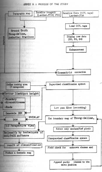
Annex A: Process of the Study
Result
|
| ||
| Categories | Area sqm. kms | Percentage of total |
|
| ||
| Water body | 2.15 | 0.39 |
| Paddy field | 108.99 | 19.96 |
| Cropland | 68.19 | 13.49 |
| Heterogeneous Orchard and Natural Stand | 108.14 | 19.81 |
| Completely Destroyed mixed with Degraded forest | 88.18 | 16.15 |
| Dty dipterocarps forest | 56.94 | 10.43 |
| Mixed Deciduous forest | 112.49 | 20.61 |
| Ather Areas | 0.84 | 0.15 |
|
| ||
| Area | 545.92 | 100.00 |
|
| ||
Gen erating of the digital Elevation Model (Dem ) of Thung-Saliam district, Sukhothai Province.
The important needed to generate DEM are:
Spatial data included contour lines, roads, rivers, streams, area boundary etc. (Vector data) and spot heights (dots) of study area which can be transformed into digital format by tablet digitizer and they will be installed in the computer memory as database.
Attributes data which instructed the software of the kinds and characteristics of spatial data installed previously.
The software will use all installed data in database to calculate Z- values by triangulated irregular network (TIN) method thousands of the altitude of study area can be obtained from existing heights spots and contour lines. Theses data are also kept as database.
Three Dimension Perspective View built-Up.
All spatial and derivative data will be overlaid over alndsat-5 TM digital image, colorful three dimension perspective View of the study area can be obtained by this techniques ( working process appears in Annex A). lands use, mountains, croplands disturbed forests etc. of Thung- Saliam can be seen vividly.
Conclusion
By using Landsat-5 TM imagery and CCT tape, containing Landsat 5-TM data Sun Ultra-1 workstation with EASI/PACE software version 6.2.2 fields data, supervised and unsupervised classification system forest cover and land use type map and perspective picture of the aea can expeditiously be obtained. This newly developed computer technique was one of he useful technique in monitoring forest resources changing being available in the market. The result obtained from this techniques are reliable and effective.