| GISdevelopment.net ---> AARS ---> ACRS 1998 ---> Education/Training |
Pilot Project for Public Use
in Thailand
Mr. Masaru
Tsukamoto
Bangkok Office, NASDA (national Space Development Agency of Japan)
B.B. Bldg. 1312, 54 Asoke Rd., Sukhumvit 21, Bangkok, 10110 Thailand
Tel: (66)-2-260-7026 Fax: (66) -2-260-7027
E-mail: nasdatha@15.th.com
Importance of Remote Sensing Activities in
NASDABangkok Office, NASDA (national Space Development Agency of Japan)
B.B. Bldg. 1312, 54 Asoke Rd., Sukhumvit 21, Bangkok, 10110 Thailand
Tel: (66)-2-260-7026 Fax: (66) -2-260-7027
E-mail: nasdatha@15.th.com
NASDA (National Space Development Agency of Japan) was established in 1969 in order to act as the center for implementing space development and promoting space utilization exclusively for peaceful purpose. NASDA'S main activities are to develop satellites and vehicles, to launch and track vehicles and satellites, to promote space experiments, to promote utilization of remote sensing data from satellites, to research and develop.
Recently, in the above several NASDA's activities, remote sensing activities have been paid more attentions. I am roughly thinking that the aim of NASDA's activities is now changing. Until now that was mainly establishment of domestic space basic technologies. We have now established. Form now that will be changing towards mainly development of useful space technologies for all over the world and humanity. In this point of view I think the first step of useful space technologies is remote sensing from space (Figure1).
Mainly Establishment of Domestic space Technologies
Mainly Development of Useful space Technologies for all over the world
| The First step is Remote Sensing From Space |
Background of Establishment of Pilot Project for Public Use
Generally speaking in Asian region there are many requirements of government agencies to utilize remote sensing data from space for public purpose, for example, city planning, map generation, agriculture consultation, environmental monitoring, fisheries. And in fact many government agencies are lacking for infrastructure of measurement of land and natural resources. On the other hand these days remote sensing technology, especially spatial resolution and image processing software is being developed remarkably. Remote sensing satellite which are available in Asian countries are increasing. Many agencies have begun to introduce Geographical Information system (GIS), input remote sensing data into their GIS and strengthen their abilities of these technologies. Therefore there are good chance for some agencies to conduct the pilot project to apply remote sensing data for their practical administrations (Figure 2).
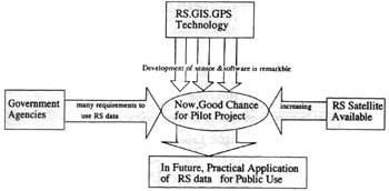
Figure 2. Background of Pilot Project for Public Use
Strategy of NASDA
From 1993 to 1997 NASDA conducted the Global Research Network Project to apply remote sensing data for scientific research with some institutes in Asain countries. In 1995 NASDA conducted the survey of the conducted some kinds sensing data in Asian region . These 5-6 years NASDA has conducted some kinds of seminars and training courses in cooperation with National Research Council of Thailand (NRCT), UN-ESCAP and Asian Institute of Technology (AIT). On January 1996 Japanese government revised the Fundamental Policy of Japan's space Activities authorizing the importance of promotion of remote sensing data utilization. On August 1996 Advanced Earth Observaing Satellite (ADEOS) was launched following MOS-1 (launched on 1987, 1990) and JERS-1 (launched on 1992).
Based on the above experiences, NASDA has recognized that it is important and timely to contribute to the practical utilization of remote sensing satellite dta in order to meet the social needs in Asian region, and NASDA started Pilot Project in Thailand from 1997. For the next program, NASDA is also planning to launch Advanced High-resolution Land Observaing Satellite (ALOS) on 2003, whose program will go into the operational phase (not pilot phase) of this practical utilization at the administrative level (Figure 3)
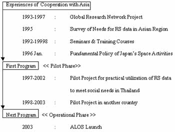
Figure 3. Strategy of NASDA
Scheme of Pilot Project for Public Use in Thailand
Under the bilateral agreement between the Royal Thai government and the government of Japan, NRCT and NASDA have established the ground receiving station for MOS-1, JERS-1 satellite at ladkrabang area in Bangkok in order to receive, process and distribute Japanese satellite data to their coverage region since 1987 (Figure4). Because of this matter, NASDA decided that the first Pilot Project for Public use in Asian region should be put into practice conducted in Thailand. After the feasibility study NASDA selected 4 agencies from 8 agencies which submitted the proposals to NRCT and NASDA.
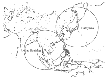
Figure 4. Coverage Region of Ground Stations
The objective of this project is to enhance capabilities of thai participating agencies in Japanese satellite data application and the promote the practical use to generate information of major crop forecasting, land cover, city planning, digital elevation model and coastal resource management in Thailand (Figure 5). Participating agencies and project themes are shown in table. The role of NASDA is to provide Japanese satellite data (MOS-1, JERS-1, ADEOS) and to provide equipment and software including maintenance. The role of NRCT is to coordinate participating agencies and to provide technical assistance and consultation. The role of AIT, which is contracted by NASDA, is to provide technical training on data analysis, image processing and evaluation. The role of 4 participating agencies is to analyze data including ground truthing, to conduct development of map as described in project themes in table and to establish map generation system as tool to extract administrative information for each agency (Figure 6). This project started on November 1997 and will continue unitl October 2002 through the interim evaluation on 2000. NRCT and NASDA concluded the cooperative agreement on the end of October 1997 to ensure the operation of this project (Figure5)
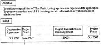
Figure 5. Objective & Period
| Participating Agency | Project Theme | On-going Study Area |
| LDD(Land Development Department) | Regional Land coverMaps of Thaliand | Central and Eastern part of Thailand |
| DTCP(Department of Town and Country Planning) | Urban land-use Maps and Digital Elevation Model | Rayong, Chanthaburi |
| DOF(Department of Fishery) | Maps of coastal prawn frams and adjacent land uses | Chanthabur, Nakhonsri-thammarat, Suratthani, Naratiwas province |
| OAE(Office of Agricultural Economics) | Production forecast of economic corps such as rice | Lopburi province |
Table 1. Project Theme & On going Study Area
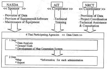
Figure 6. Role of Each Organization
On-going Activities and Results of Pilot Project in Thailand
Thai participating agencies have been improving their capabilities with provision of new equipments, specific training programs and daily technical assistances. The first intensive training course for this project was held on January 19-28,1998 in ATM (mainly basic analysis) and Chanthaburi province (field survey to verify the analysis result). About 10 trainees from participating agencies attended this course. The seminar including topics of this project was held on February 13, 1998 in NRCT. The second intensive training course was held on Octomber 12-16, 1998 in NRCT (mainly advanced analysis using Thai language).
Regretably ADEOS malfunctioned June 30, 1997, but we already got approximately 200 good scenes of ADEOS data in Thailand which covers about 25% of whole Thailand and now we are providing these data to agencies. On-going study area of each agency is indicated in table Each agency has already made some results. Department of Fishery (DOF) has got the prospect of evaluation of potential prawn production in some coastal area by analyzing JERS-1/OPS image data. DOF is now challenging to develop the analysis method and improve the accuracy of evaluation. Land Development Department (LDD) has got some provincial land cover map of some part of study area using JERS-1/OPS. LDD is now trying to make the regional land cover map using JERS-1/OPS and ADEOS/AVNIR. Department of Town and country Planning (DTCP) has got some topographic map on Digital Elevation Model (DEM) using JERS-1/OPS in their study area. DTCP is now trying to make urban land-use map using JERS-1/OPS and ADEOS/AVNIR. Office of Agricultural Ecoomics (OAE) has got the land cover map of Lopburi province using JERS-1/OPS, in order to assess the economic crops area mapping. OAE is now trying to monitor the growth of economic crops using JERS-1/SAR.
Project Planning in Future
The seminar including on-going results of this project will be held on February 1999 in NRCT. We believe that this project shall bring a major step of Japanese data utilization of government user community in Thailand in the near future. Now Bangkok office is making efforts to support this project, because I think Japanese satellite data should be utilized more efficiently and widely in Thailand than until now.
Meanwhile NASDA is planning to begin the second Pilot Project for Public Use with Indonesian government from this Japanese fiscal year (by March 1999) and now is negotiating with Indonesian government about the preparation of the project program. Successful start is strongly expected.