| GISdevelopment.net ---> AARS ---> ACRS 1998 ---> Education/Training |
Activities of Education,
Training and Research at Asian Institute of Technology
Shunji Murai, Lal
Samarakoon and Kiyoshi Honda
Space Technology Applications and Research (STAR) Program
School of Environment, Resources and Development
Asian Institute of Technology
P.O. Box 4 Klong Luang, Pathumthani 12120, Thailand
E-mail : murai@ait.ac.th
AbstractSpace Technology Applications and Research (STAR) Program
School of Environment, Resources and Development
Asian Institute of Technology
P.O. Box 4 Klong Luang, Pathumthani 12120, Thailand
E-mail : murai@ait.ac.th
STAR Program, AIT has reformed and restructured the goals as well as curricuta to meet requirements and demands in computer, space and multi-media age. STAR Program has been reorganized with three components of education, training and research that feed back each other in not only academic development but also financial infrastructure.
This paper will introduce the organization and several successful results due to the restructuring.
Introduction
Since " Earth Summit" was held in Rio de Janeiro in 1992 with the new concept of "sustainable development", and Beijing Declaration" was announced at Ministerial Conference of UN/ESCAP on Space Technologies for Environmentally sound and Sustainable Development held in Bejing, China in September 1994, space technology including remote sensing, GIS, GPS space telecommunication etc. has become a key word of tool for environment and natural resources management in Asia and Pacific.
In this regards, a new name of STAR Program replaced the former name of "Natural Resources Program" at AIT in 1995 with a focus on space technology rather than application-oriented program. Taking into account the maximum use of benefit as graduate school of AIT, there components of education, training and research have been interactively organized for mutual benefit (see Figure1).
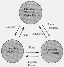
Figure 1 Three Components of STAR Program, AIT
Education for master and doctoral courses at STAR program is consisted of two field of study; Remote sensing and Geographic Information Systems (RS & GIS) and computer Mapping Technology.
Star Program is fully equipped with PCs and UNIX stations as well as software for high quality computer laboratory sessions. The curricula have been also restructured with a target on computer-assisted teaching. Not only techniques to use the existing software but also capability of software development are now being strengthened in the courses.
Sort-term training course with a specific theme will be a bit contribution to scientists and engineers in Asia and Pacific who had not chance to study modern and advanced technology in geoinformatics. STAR Prgogram established GIS Application Center (GAC) with financial support of UNEP EAP-AP in 1995. Since then GAC has conducted not only fundamental courses on remote sensing and/or GIS, but also advanced courses with a specific theme such as watershed management, flood mitigation, land use planning etc. with UNIX workstations.
Recognizing that research is very poor and technical support to researchers is a key issue in developing countries, STAR Program has jointly established Asian Center for Research on Remote Sensing (ACRoRS) in 1997 with Asian Association on Remote Sensing (AARS) (see Figure 2).
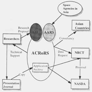
Figure 2. Organization of ACRoRS
ACRoRS will be able to provide researchers with NOAA AVHRR and Japanese Satellite Data such as JERS-1 OPS/SAR at inexpensive rate.
Strategic Goals of STAR Program
After almost five year argument about the goals in consideration of requirements, demands and geographic location of AIT, STAR Program reached these resolutions as follows.
STAR Program should focus on technology oriented courses rather than applications oriented ones. There are tow reasons behind this goal. One is that a limited number of faculty cannot cover all application fields such as tropical forest, landuse planning, land degradation, tropical coastal zaones, disaster management, watershed management etc. The second reason is that high quality graduate students can survive in any application field, if they have a strong technical background.
However STAR program should develop applicability of the technology in the Master and Doctor thesis. Because STAR program is a graduate school with only Master and Doctor courses, the students have already engineering or scientific background in a specific field. Therefore, it is not very difficult for these students to apply the high level technology to their speciality.
STAR Program should encourage more research and publications of journal papers. This is a philosophy behind this goal, that is, only a top runner of research can lead highest quality education in a graduate school.
STAR Program should strengthen the ability of software development rather than the skill how to use the existing software or models, As a graduate schools, we don't need to produce just computer operators. We need software developers who develop their own software or models to solve environmental problems that cannot be solved with existing software alone.
STAR Program should grow professional researchers by continuing to support the finance for outstanding graduates. In the same way, STAR Program should accept outstanding young researchers from outside, for promotion of research.
Education Program in Master Course
According to the goals, STAR Program has set up the following curriculum guideline for Master course in five terms of twenty months.
Basic configuration of terms (ss appendix 1)
First Term: Lectures of fundamental theory and principle. This is to standardize the level of master students.
Second Term: Lectures with computer laboratory sessions. This is to develop the software capability by hands-on-training.
Third Term: Lectures with advanced technologies. This is to strengthen the student's knowledges with a target on the subsequent master thesis. Special study with literature review will be also suggested to students. Proposal defense of master thesis should be passed.
Fourth Term: Master thesis research including preprocessing remote sensing and GIS data and field study. Progress report should be passed.
Fifth Term: Master thesis research including editing master thesis and final final defense with oral presentation in an open door seminar style.
Appendix 1 Curicula of STAR program, AIT
| Field of Study | |
| Remote Sensing & GIS | Computer Mapping Technology |
| January Term 1999 | January Term 1999 |
|
|
|
| May Term 1999 | May Term 1999 |
|
|
|
| September Term 1999 | September Term 1999 |
|
|
|
| · Challenges in space Technology (Overseas Experts will be invited to provide students with latest information | |
Computer Facilities
In order to provide students with well installed computer systems, STAR Program has following laboratories and facilities for supporting Master and Doctor courses.
Remote Sensing Laboratroy
10 pentium PCs with 10 set of ARC/INFO, IDRISI, ERDAS and ENVI with NT server. Color plotters, digitizers and image scanner are also installed. Students are given 200 M bytes disk space at minimum, another 200 M bytes on request and more on special request.
Maps and satellite images/tapes are open to students.
Photographic processing facility is installed to convert from digital data to photo and enlarge photos for image interpretation.
UNIX Workstations and PCs are installed to support doctoral students.
Documentation Room
Word processors and printers are installed for documentation of papers. PCs in Digital Lab. Are prohibited to use as a word processor.
Education problems
STAR Program has following problems, though it has improved remarkably as compared with five year ago.
Limited number of scholarship
Financial support in a form of scholarship is most essential. Tuition fee, academic service fee and living expense (accommodation and food) per term is 3,400 US dollars, 240 US dollars and about 1,000 US dollars respectively that make the total cost of Master Course (5 terms) 23,200 US Dollars, while Doctor Course (9terms) 41,760 US dollars.
Because AIT students come from various countries in Asia and Pacific (almost 30 countries), the level of quality at the enrollment is so different that the target of courses should be carefully chosen. STAR program will target top 30 percent as a strategy rather than bottom class in order to keep the high quality.
Limited research budget
Budget for supporting master thesis is limited only about 300~ 400 US dollars. It makes students difficult to purchase satellite data and to go to field study. Individual faculty will have to find extra funds to support advisees. In this sense, STAR Program most welcomes to receive complementary satellite data for educational purpose from space agencies.
Training Program
The GIS Application Center (GAC), AIT provides end users of remote sensing and GIS with two types of short-term training course.
Regular Courses: in 1998 three courses are planned, Basic GIS Course (13-24July 1998), Advanced GIS for Watershed Management (27 August - 7 September 1998) and Advanced GIS for Flood Mitigation (7-18 December, 1998). Each course costs 2,000 US dollars including accommodation, with the maximum 20 trainees.
Sponsored courses: NASDA (National Space Development of Japan) sponsored GAS, AIT to conduct three two week training courses for 15 trainees each with full support of travel, accommodations and per diem. Another 5 trainees will be accepted to join the courses with self support fund to 2,000 US dollars.
They are; Advanced Remote Sensing & GIS for Watershed Management (15-30 June, 1998), Microwave Remote Sensing and Interpretation (21 Sep. ~2 Oct. 1998) and Advanced Remote sensing & GIS for Flood Mitigation (16-27 November, 1998). Another two training courses called "Caravan Type Training" will be conducted with full support of AIT/NASDA outside of AIT. A caravan team of several resource persons will visit a local city to conduct workshop or tutorials on a specific theme in order to maximize the efficiency of number of trainees in the host country.
In 1998, the following two "caravan term of several resources persons will visit a local city to conduct workshop or tutorials on a specific theme in order to maximize the efficiency of number of trainees in the host country. In 1998, the following two "caravan type training" courses are to be scheduled.
Workshop on Remote Sensing, GIS Utilization 19-23, August, 1998, Bandung, Indonesia.
AIT-Hannover University Joint Workshop on Mapping from Space 26-30 Octomber 1998, Ho Chi Minh, Vietnam
Research Program
The Asian Center for Research on Remote Sensing (ACRoRS) aims at the following tasks
- To provide technical support to researchers in Asia.
- toprovide NOAA AVHRR data and Japanese Satellite data at inexpensive price for research purpose.
- to promote joint research with AARS members, and
- to provide consulting service on request
The cost of NOAA AVHRR in 8 mm tape is 30 US dollars per path, 200 US dollars per 8 mm tape (about 47 paths) and 10,000 US dollars per year.
Visiting researchers are most welcome to join the "working together" type of research with full technical support by ACRoRS experts. The tuition fee for visiting researcher costs 2,000 Us dollars per person per term. Accommodation and food will be about 1,000 US dollars per month if stayed in AIT campus.
The ACRoRS is implementing on-going projects in 1998 including "preliminary study on applicability of satellite data to Asian Highway", "Production of mosaics of whole Thailand with Japanese Satellite data", "Estimation of water volume of Ton Le Sap Lake, Cambodia", "Application of remote sensing and GIS to road planning and maintenance in Nepal" etc.
Appendix 2 Faculty of STAR Program (as of August, 1999)
| Full Time Faculty |
|
(Program coordinator) Dr. Kaew Nualchawee, Associate Professor, GIS Dr. Jean Pierre Delsol, Associate Professor, Remote Sesning Applications Dr. Kiyoshi Honda, Associate Professor, Image processing, RS |
| Affiliated faculty |
|
Dr. surat Lertlum. ACRoRS Expert, NOAD AVHRR Dr. Krishna Pahari, Research & Education Development, Global Study |
| Visiting Faculty |
|
|
Conclusions
- STAR Program, AIT has successfully developed the curricula with a clearly targeted goal to meet the requirements and demands in computer, space and multi-media age.
- STAR Program has established a well balanced scheme between educational, training and research program.
- STAR Program has a resolution toward technology and research oriented program , with powerful equipments and highly capable researchers.