| GISdevelopment.net ---> AARS ---> ACRS 1998 ---> Education/Training |
The four dimensions of
GIS
A geographic Information System (GIS) can be defined as a computer-based system to collect, store, analyze, retrieve and display geographic information. It consists of at least four main components, namely: hardware/software, information, people who operate the system, and the organizational context (work and information flow, number of hierachical levels, etc).
GIS has been around in the "western world" for approximately two decades and in South-East Asia for less than ten years. It can be observed that implementing agencies often focus strongly on technical aspects (Hard-and software), but underestimate the other three components, resulting in a less than optimal utilization of GIS for effective decision making. While often enough large budgets are approved for implementing the technology, little is done to prepare the institution and the people to handle this, In addition, the lack of sufficient, valid and updated data is a problem, which often results in under-utilization of GIS as planning tool.
The-four dimensional model
The author has developed a model showing different levels of sophistication of Geographic information systems in four dimensions. It was first applied during a feasibility study for the Philippine-German Community Forestry Project-Quirino(1996) and then during formulation of a GIS master plan for the State of Sarawak, East-malaysia (1997).
The model was originally developed to benchmark and evaluate existing GIS project, but proofed to be also an ideal instrument to determine the readiness of the frame conditions for establishing a new GIS (TRAUB 1997).
In this model the degree of sophistication increases as one moves away from the center of the figure. If all four dimensions are developed at an equal pace, the operations of a GIS are more likely to be sustained. If an implementing agency has not yet reached the first level of one or more of the four dimension, an immediate establishment of GIS without any preparatory steps is not recommended.
"Humanware" qualifies the abilities (education, skills, experience, etc.) of personnel, "Technoware" relates to the physical facilities (equipment, software, office infrastructure, etc.). The "Infoware" dimension covers the data aspect (quality and coverage) and "Orgaware" relates to practices, linkages and organizational frameworks.
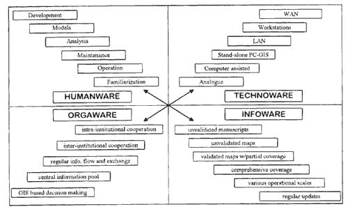
Fig.1: Degrees of Sophistication of a GIS in four dimensions
Humanware
The Humanware dimension is represented as six possible degrees of sophistication: for "being familiar" with GIS, up to a level where new developments or innovations take place. The different stages are explained in greater detail below:
- Familiarization: The concept of GIS is known and understood by the people
- Operation: Off-the-shelf application software can be operated and standard functions can be handled by the staff
- Maintenance: The status quo of the system can be maintained without outside support
- Analysis: Critical analysis and interpretation of GIS data can be performed
- Models: Scenarios and models of real world can be developed for decision-support
- Development: New applications and/or software can be created
Orgaware
The Orgaware dimension can be defined in five stages, starting from "intra-institutional cooperation" up to "GIS based decision-making"
- Intra-institutional Cooperation: different divisions/sections within an institution cooperate regularly (internal linkages) with regard to data exchange
- Inter-institutional cooperation: different institutions interact and cooperate with each other on a project basis (external linkages)
- Regular information flow and exchange : A systematic and regular data sharing and exchange procedure is implemented
- Central information pool: A host institution is mandated to be the central data depository
- GIS based decision-making: Decision-makers within an institution base their decisions on GIS outputs and products
Infoware
The quality and quantity of available data contributes significantly to the success of any GIS (to have the right data at the right time readily available). If the GIS can answer questions, which nobody asks, the acceptance of end-users will be naturally limited.
It is possible to define a series of different stages of sophistication with regard to data and information.
- Unvalidated manuscripts: documents without basic cartographic features (coordinates, scale, etc.), analog-digital conversion therefore becomes difficult, if not impossible;
- Unvalidated maps: Thematic maps whose content and accuracy have not been validated ;
- Validated maps with partial coverage: Topographic and thematic maps are available for some areas only
- Comprehensive coverage: Topographic maps at full coverage and various thematic layers available;
- Various operational scales; Topographic and thematic maps in a variety of scales available;
- Regular updates: Topographic and thematic maps are regularly updated.
The technoware dimension has proved to be the least complicated in terms of establishing GIS as hard-and software are readily available in the market. Office facilities, which must be seen as part of the technoware category, and infrastructure, can usually be provided without major problems, like budgetary constraints. However, in terms of the sophistication of GIS technology, several levels within the technoware dimension can be identified. These are:
- Analog: Manual GIS operation are carried out (overlay on a lighttabe, pantographic rescaling, etc.)
- Computer-asisted: Manual GIS operations are assisted by CAD and DTP systems
- Stand-along PC GIS operations are assisted by CAD and DTP systems
- Stand-alone PC GIS: GIS operations are done using specialized GIS application software
- Local Area Network (LAN): Several users practice file sharing in a server/client environment with a centralized DBMS
- Workstations: Platforms based on UNIX systems are used for GIS operations
- Wide Area Networks (WAN) : Several offices are connected together (e.g. throughout a district, state or even country) and can freely exchange their data.
With regard to relative costs of establishing and operating a Geographic information System in all four dimensions, the figure below illustrates its magnitude and distribution. In general, the preparation and development of the organization(Orgaware) for the GIS implementation present the greatest cost, followed by he acquisition and management of data (Inforware), then personnel related expenses (Humanware). Hardware and software costs (Technoware) represent the lowest. The absolute costs of implementing and maintaining a GIS depend on the actual degree of sophistication of the system.
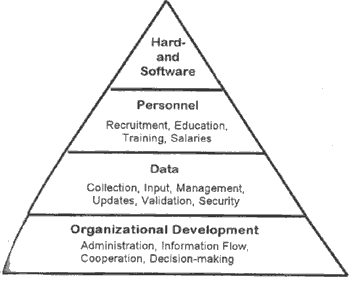
Fig. 2: Relative Costs of a GIS
Outlook
The four dimensional model has been developed to qualify levels of sophistication of GIS, and the frame conditions within which a GIS is established. It does not mean that the highest level of any dimension is necessarily the most desirable one. Quite often, simpler solutions might be far more adequate and appropriate than more sophisticated ones.
References
- TRAUB, K.-P. (1996): Implementing a National GIS for Woody Cover Mapping in Zimbabwe: The Vegetation Resources Information System (VegRIS). GIS 9/3. Karlsruhe.
- TRAUB, K.-P./LLANTO, R.B. (1996): Feasibility Study for the Implementation of a Geographic Information System for Landuse Planning in the province of Quirine. Cebu City (unpublished report)
- TRAUB, K.-P.(1997): The four dimensions of GIS. GIS Asia/Pacific, February 1997. Singapore.