| GISdevelopment.net ---> AARS ---> ACRS 1998 ---> Disasters/Pollutions |
The Application of Remote
Sensing and Hydrological model on Water Conservation Capacity Estimation
For Reservior Watershed Area
Tien- Yin Chou, Mei-Hsin
Chen and Lung-Shin Yang,
GIS Research Center, Feng Chin University
100 WENHWA RD., Taichung, Taiwan, R.O.C.
Tel : 886-4-4516669 FAX : 889-4-4519278.
E-mail: tychou@fcu.edu.tw
AbstractGIS Research Center, Feng Chin University
100 WENHWA RD., Taichung, Taiwan, R.O.C.
Tel : 886-4-4516669 FAX : 889-4-4519278.
E-mail: tychou@fcu.edu.tw
The recent increased pressure on slope land development in Taiwan has changed the land use pattern in many reservoir watershed areas and affected the hydrologic cycle. These were many local researches examined this related issue, but none of that can fully describe the relationship between water conservation capacity and land use patterns in watershed area. This study is to integrate and analyze the impact to water conservation from deforestation or other land use pattern changes. Geographic Information System (GIS) were adopted to build a digital database for reservoir area and to process hydrologic analysis. Remote Sensing (RS) and Global Positioning System (GPS) were performed to extract and identify the surface vegetation details and land use changes information. By the assist of hydrologic model for water conservation capacity estimation from land use changes, the outcome of this study can provide an important reference for sound watershed management. This study identified the parameters to be used in heuristic HSPF model from waterguage station in Dapu Reservoir watershed. Four designed rainstorm simulation events were proved to fit the observed peak. The erosion estimation outcomes from Erosion Index Model (EIM) have been tested to correspond the tendency of higher erosion due to land use changes.
Introduction
The yearly average precipitation in Taiwan area is about 2510 mm, which is 2.6 timed over the world average value. But due to abundant of mountain area, vulnerable geological structure, steep topography, short and rush river flow, and inconsistent precipitation, the difficult in water storage and resources allocation reveals the importance of water conservation.
In recent years, the remarkable industrial business and economic development in Taiwan have enhanced the urgent demand for water resources. The recent increased pressure on slope land development has changed the land use pattern in man y reservoir watershed areas and affected the hydrologic cycle. Although there were many local researches examined this related issue, but none of that can describe the relationship between water conservation and land use pattern in watershed area.
In this research, Geographic Information System (GIS) were adopted to build database for reservoir area and to process hydrologic analysis. Remote Sensing (RS) and Global Positioning System (GPS) were performed to extract the surface vegetation details and land use change information. The final goal of this study is through the assist of hydrologic model for water conservation capacity estimation; the outcome can provide an important reference for watershed management.
Study Area
The study area for model application is Dar-Pu reservoir watershed with 10,000 hectare in area, which locates at the upper stream of E-Mei River with discharges through the north western of Taiwan. The original construction purpose for this reservoir was to provide irrigation supply for neighborhood irrigation at county level.
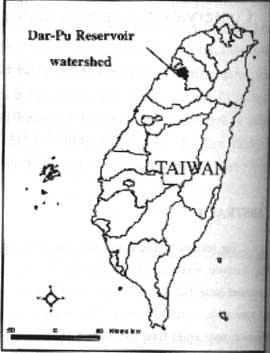
Figure 1. The Study Area - DaPu Reservoir Watershed Location Map
Research Procedure
This research consists four major parts: Hydrologic factors (parameter) analysis for water conservation capacity, Environmental database establishment for watershed area, hydrologic model evaluation and model analysis for research area.
The first part of this research was to determine those influenced the hydrological processes, which include water balance parameters extracted from various input data of hydrological model. Secondly. An environmentally sound database was built using GIS,RS and GPS technologies. Then choosing a suitable hydrologic model to best estimate the quantity of water conservation capacity. The last part to link the database with water conservation model and estimate the chares due to land use development.
Hydrologic Factors( Parameters) Analysis
From previous research output, those affect water conservation capacity of reservoir watershed in Taiwan can be identified, which include the vegetation factors, topographic factor, soil factor, hydrometerological factor... etc. In this study, some general variables and data are used as show in table 1.
| Factor | Data requirements |
| Vegetation | Land cover/use (forest type and density) |
| Topography | Slope/aspect,elevation |
| Soil | Soil moisture content, antecedent mosture content, soil profile |
| Hydrometerology | Precipitation, water level and discharge volume at gauging stations |
Environmental Database Establishment for Watershed Area
All parameters for hydrological model, include vegetation, topography, land cover/use. Slope/aspect, elevation and gauge station distributing map... etc., can be built into a physical Environment database by the assist of GIS and RS techniques.
This physical Environmental database includes basic data such as geographical features, geological characteristics, hydrological information, and land use/cover information. Among those data set, the geology. Digital Elevation Model (DEM) data, forest stands polygons and land use information were available in digital format. These data were transformed into transverse Mercator 2-degree projection, which is the coordination system currently used in Taiwan
Satellite Image Source
SPOT image were used to detect land use change in this study due to better spatial resolution. Three image from different seasons were chose for this study, one was taken on December 8,1993, another was on Aril 17,1996, and the other was taken on November 19,1997.
Land Use Classification
The land use classification process was focused in identifying vegetation area. First unsupervised classification was used to group the nature categories in the image. Then candidate training sites for supervised classification were first identified from aerial photos topographic maps. Field observations were also performed to check the ground truths and to select final training sites.
These SPOT satellite image respectively were used to identify the land use/cover condition in Dar-pu watershed area. Through these different season images. The land use changes output and land use distribution information can serve as the input parameters for the hydrological model of water conservation capacity estimation .using satellite image to get the land use patterns and land use changes for large area is efficient in both time and cost. The result from image classification are show in table 2.
|
Image date Land use/cover |
12/8/1993 Area (hectare) |
4/17/1996 Area (hectare) |
11/19/1997 Area (hectare) |
| Forest | 6410.13 | 6181.88 | 6102.68 |
| Orchard | 1799.83 | 2070.52 | 2329.28 |
| Crop field | 773.49 | 483.98 | 425.74 |
| Paddy rice | 377.47 | 431.83 | 465.04 |
| Water | 185.59 | 150.62 | 211.38 |
| Road | 145.76 | 145.57 | 146.30 |
| Build up area | 203.59 | 423.77 | 473.53 |
| Bare land/landslides | 77.14 | 379.45 | 255.47 |
| Grass land | 493.23 | 175.83 | 52.47 |
| Undistinguished | 0 | 22.77 | 4.31 |
| Total | 10466.22 | 10466.22 | 10466.22 |
Hydrological Model Analysis
Assuming the reservoir watershed is persuadable, this study applied PWATER subroutine from PERLAND module of HSPF model. The PWATER structure is shown in figure 2. the main function is to simulate total runoff from percolating area. This research focused on the simulation result from PERLAND module for surface runoff from groundwater changes in reservoir watershed.
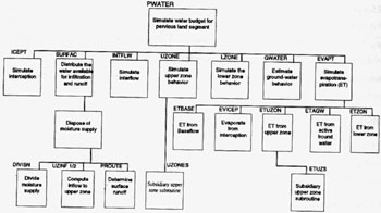
Figure 2. Structure Diagram of PWATER subroutine from HSPF model
Results from Hydrological Model Simulation
These are seven sub-watershed was shown as figure 3. the boundary of each sub-watershed was derived from calculating Digital Elevation Model (DEM) data through a previous developed program. In this study, the examined area was sub watershed 4,5,6,7. The genetic algorithms was applied to test the parameters for four observed storms data from e-mei water-gauge which can cover the whole basin area for the four examined sub-watersheds. The result of simulation from four storm were shown in table 3. figure 4 to figure 7 show the hydrological model can efficiently simulate the change trend of run-off volume from each observing data set.
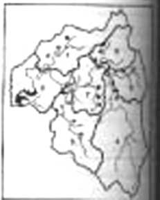
Figure 3. The sub-watershed delineation map of Dar-Pu reservoir watershed area, sub-watersheds 4,5,6,7 were the examined areas for model simulation.
|
Storm date Parameters |
5/4/1996 | 8/16/1996 | 6/24/1997 | 1/14/1998 |
| Lower zone nominal storage. (LZSN) | 429.98 | 429.98 | 429.98 | 429.98 |
| Index to the infiltration capacity of the soil. (INFILT) | 37.4 | 37.40 | 36.70 | 36.70 |
| Exponent in the infiltration equation. (INFEXP) | 2.04 | 2.04 | 2.04 | 2.04 |
| The fraction of groundwater inflow (DEPER) | 0.42 | 0.42 | 0.40 | 0.40 |
| Upper zone nominal storage (UZSN) | 25.15 | 25.15 | 25.15 | 25.15 |
| Manning's n for assumed overland flow plan. | 0.20 | 0.20 | 0.25 | 0.25 |
| Interflow inflow parameter (INTFW) | 1.04 | 1.04 | 1.04 | 1.04 |
| Interflow recession parameter.(IRC) | 0.07 | 0.07 | 0.07 | 0.07 |
| Daily recession constant of ground flow (AGWRC) | 0.01 | 0.01 | 0.02 | 0.02 |
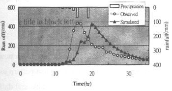
Figure 4. Run-off simulation result for 5/14/1996
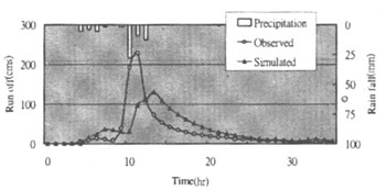
Figure 5. Run-off simulation result for 8/16/1996
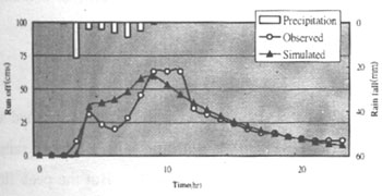
Figure 6. Run-off simulation result for 6/24/1997
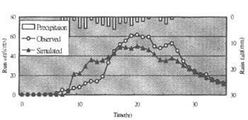
Figure 7. Run-off simulation result for 1/14/1998
The difference of run -off simulation results
A total of 60-mm precipitation with triangle shape was designed in this study to discuss the changes for different storm events simulation. Thought HSPF model process to simulate the run off volume with modified parameters(table 3), figure 8 shows that the volume curve ahead faster before the flood peak. The peak in 1996 was higher than that in 1997, and the simulated curve receded from flood peak in 1996 was less than that in 1997. The result also showed a higher total run off volume in 1996 due to the run-off coefficients used for simulation process in 1996 and 1997 were 0.96 and 0.94 respectively.
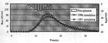
Figure 8. Run-off simulation output curves for 60 mm precipitaion event.
Erosion assessment
Erosion Index Model (EIM) was proposed from another research project of Water Resource Bureau titled "The derived equation was used to simulate erosion due to land use changes from 1993 to 1997 in Dar-Pu Reservoir Watershed area.
The Erosion Index Model is as following :
SE = 6*10-7 AI5.12 _ __ __ __ __ __ __
For AI>50
SE = 0.233Al1.83
Al : Total Index Value (Al +Rl+Kl+Tl+Cl+Ul),
where Rl : rain fall index ;
Kl: soil index;
Tl: topography index;
Cl: cover index;
Ul: and use index;
Conclusion And Discussion
This study has shown the integration of GIS and Remote Sensing technologies can provide a powerful tool in assisting watershed management. Remote sensing images can be used to identify land use pattern as well as land use change detection in a cost effectively way. GIS technology was used to transform physical data into an environmental database for study area. HSPF model and GIS database were linked to analyze the image to water conservation capacity from land use changes. In further study, the final resulted numerical figures for watered conservation capacity estimation can assist the government in managing the controversy of economics development and resources conservation issues.
HSPF Model Assessment
By using limit hydrological data source, the parameters of HSPF model for the upper watershed area along E-Mei water gauge station were defined. Through running the same designed rainfall in 1996 and 1997 respectively, the simulated run off curved got in identical flood peak. But the peak flood volume in 1996 (100.4 CMS) was near 5% higher than that in 1997 in 1997 (95.47 CMS)
Land use changes vs. Water conversation capacity
Base on the land use changes analysis from satellite image in 4/17/196 and 11/19/1997, the result showed a quantitative changes sequence as:forest, orchard>rice land>road, build up area, bare land. The relationship between each identified land use and water convservation capacities was defined. The ratio of each land use change pattern in confirmed area was described on table 4. It shows that forest and orchard area changed over 70% between the two years. Only 8% of land area has become road, build up area or bare land where proved to have lower water conservation capacities. Through the relationship between land use changes and water conservation capacities analysis, the water conservation capacity in 1997 was increased. This result fits the reduce flood peak from HSPF model simulation output.
|
Changed land use area Origin land use area |
Forest, Orchard | Rice field, Corp land | Grass field | Road, build up area, Bare land |
| Forest (685ha) | 75.3 | 16.0 | 0.7 | 8.0 |
| Orchard (584ha) | 66.6 | 12.2 | 0.1 | 11.3 |
| Grass (79ha) | 82.0 | 7.3 | - | 10.7 |
| Bare land (229ha) | 79.4 | 7.8 | 6.5 | - |
Erosion assessment for 1993 to 1997
In this study erosion volume in 1996 was twofold in 1993 from Erosion Index Model simulation caused by the bare land area increase.
| Year | Average erosion (ton/ha) | Total Erosion (ton) |
| 1993 | 3.2927 | 32927.07 |
| 1996 | 7.3948 | 73948.41 |
| 1997 | 7.1608 | 71608.03 |