| GISdevelopment.net ---> AARS ---> ACRS 1998 ---> Digital Image Processing |
Combining The Spectral and
Spatial Signature of Information Classes using Artificial Neural Network
Based Classifier for Remote Sensing of Spatially Heterogeneous
Land-Use/Land Cover System in the Tropics
Joel
C.Bandibas
Research center, Cavite State University,
4122 Indang, Cavite, Philipines
Tel :046-4150020; Fax: 046-4150012
E-mail: bandibas@gpu.srv.ualberta.ca
AbstractResearch center, Cavite State University,
4122 Indang, Cavite, Philipines
Tel :046-4150020; Fax: 046-4150012
E-mail: bandibas@gpu.srv.ualberta.ca
This study focused on the extraction of the spectral signature of satellite images with high spatial frequency using a revolutionary computing methodology known as the artificial neural network (ANN) computing. This method models how the neurons in the human brain process data to identify complex and noisy patterns of information. An error back-propagation artificial neural network structure to model the spatial and spectral signatures of information classes in digital images was successfully developed.
The developed computing methodology was successfully applied in the mapping of the land-use/land cover types of Aurora province, Philippines. Using the artificial neural network, the combined information class signatures was successfully used to classify the artificial the Landsat TM multispectral satellite image of the study area. For comparison purpose, the image was also classified using the established maximum likelihood classifier (MLC).The high intra-class variability and spectral response similarities between information classes contributed to the low classification accuracy using the MLC. This problem was solved when the classification methodology using the designed artificial neural network was applied. Result showed that the artificial neural network gave a significantly higher overall classification accuracy (86 %) compared to the accuracy obtained (76%) using the MLC.
Introduction
Satellite images in tropical countries are generally characterized by their high spatial frequency. This attribute generally results to lower classification accuracy when the images are classified using the conventional spectral signature based classifiers. Recent studies suggest that spatial signatures of information classes in satellite images can be a good discriminatory attribute that can potentially increase the satellite image classification accuracy. Consequently, combining the spectral and spatial signatures of information classes in high spatial frequency satellite images can be the best method in classifying digital images with the aforementioned attribute.
Modeling the spatial signature of information classes satellite images is the bottleneck in the development of spatial signature based classifiers. Developing an algorithm to extract the spatial signature such as geometrical shapes, sizes and arrangement of pixel that directly relate to an information class in satellite images is very interpretation which basically utilizes our brain's capacity to identify complex and noisy patterns of information. Just recently, a new computing method that Simulates the way the neurons in our brain process information was developed known as the artificial neural network (ANN) computing. This can be used to extract the spatial signatures of information classes in satellite images.
Recent developments in the field of ANN computing have provided potential alternatives to the traditional techniques of pattern recognition (Khotanzad and Lu, 1991). In fact, some studies found the use of ANN for digital image calcification promising. Ming et al.(1994) used an ANN (radial base function ) in classifying spot images while Shoshany and Guedalia (1994) used an ANN (Kohenen Feature Map) in mapping vegetation using aerial photographs. On the other hand, Homosura and pallewatta (1994) used the ANN in detecting land cover change. However, ANN based classifier which extracts the spectral and spatial signatures of information classes in satellite images has yet to be developed.
This study aims to develop an accurate image classification method using ANN computing, with emphasis on the developments of an error back-propagation artificial neural network structure to model the spatial and spectral signatures of information classes in digital images. The resulting neural network was successfully applied for the mapping of the land-use/land cover types of the Landsat TM image in a portion of the Aurora province in the Philippines.
Methodology
The Artificial Neural Networks
An ANN is a parallel processing method which simulates the brains bio-neurological structure (Shoshany and Guedalia, 1994). Its simplest element, the nodes can be made to store experiential knowledge through the process of task examples. The nodes simulate the functions of the fundamental cells of the brain, the neurons, together with the function of the cells' dendrites and axons, the cells' output and input fibers, respectively. Knowledge of pattern recognition can be modeled within the ANN through training. It is through this method where information patterns will be presented in the input layer of a neural network while the output layer will be "forced" to output the desired results. It is through constant repetition of this process that the network will learn to output the correct solution in response to the presented input signal in the input layer. Once training is completed, knowledge is said to be successfully modeled within the ANN and the networks are now available for use.
In computer terms, the process is called ANN training. The following is an example of a three-layered ANN with one node in each layer.
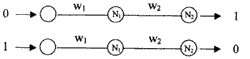
Clearly, the network is trained to output 1 when the input is 0 and output 0 when the input is 1. In this example, the training patterns are (0,1) and (1,0) representing the inputs and outputs, respectively. Using a particular computing Method, the network can be stimulated to generate outputs (1 and 0) using the training inputs (0 and 1), the weights (W1 and W2) and the nodes' thresholds (N1 and N2). Using this scheme, the network will be repeatedly fed with the training inputs and "forced" to generate the training outputs by adjusting the values of the weights and thresholds. After a certain number of iterations the network started to learn how to output nearer to 1 when the input is 0 and nearer to 0 when the input is 1. The details of the mathematics behind the computations during ANN training are given by Bandibas (1995), Alexander and Morton (1990) and Rumelhart et al. (1996)
Designing ANN to Model the spatial and Spectral Signatures of Information Classes
Based from the aforementioned approach, a bigger ANN can be designed and trained to extract spatial and spectral signatures of information classes in satellite images. Figure 1 shows the structure of the ANN for the spatial and spectral signature extraction of information classes in digital images. The number of ANNs is equal to the number of information classes consider. To extract spatial pattern in the images, a pixel window was defined. The pixel values and their unique spatial arrangement in that windows will be the spatial identity of the central pixel in that window. On the other hand, the spectral information was also incorporated into the spatial signature by using more than one spectral bands during the pixel window definition.
Supervised Training
In this study, training areas were specified during the field survey of the study site. The pixel window was moved over the specified training area for each information class and sample patterns were extracted. A Borland Turbo C++ programming language was specifically written for the sampling of pixels. The program was run on a 486 IBM compatible personal computer.
ANN Training and Classification Strategy
Training the network involves the presentation of the representative patterns of all the information classes to the network. As shown in Figure 1, each class has its corresponding network. Obviously, each of these networks has only one output neuron which was designed to output a continuous value ranging from 0 to 1. During the training, all patterns from al the information classes were presented to each of these networks. If a pattern entered belongs to that network's corresponding class, it is "taught" to output 1, otherwise, it is trained to output 0. After several iterations, the network started to learn to output higher values (closer to 1) if the pattern presented belongs to the current class trained and lower output (closer to o) If the presented pattern belongs to another class. In this study training ended when the networks can classify the training data with an accuracy of more than 95%. This required periodic testing of the networks' performance after a designated number of iterations interval. Testing involved the entry of a training pattern to all the classes' network. The one which gave the highest value (nearest to 1) is the "winner". This means that it was this network's corresponding class where this pattern belongs. This process was repeated using all the training patterns and the classification accuracy was computed. Similar Procedure was followed during the classification. In this case, the pixel window was moved over the multispectral images and the extracted pixel pattern was presented to all the information classes' trained networks. The corresponding class network that gave the highest value is the class label to be assigned to the center pixel of the window.
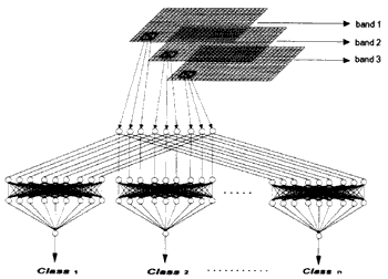
Figure 1.The Error Black-Propagation ANN Structure for the extraction of the spectral and spatial signature of information classes using 3 satellite bands and a 3 by 3 pixel window with n number of information classes.
Results and Discussion
Table 1 shows the summary of the classification accuracy of each of the information classes and the overall classification accuracies using the two classification methods. Evidently, the agreement between the classification results and the reference data is high using the ANN classification approach compared to the MLC. The maximum likelihood classifier approach compared to the MLC. The maximum likelihood classifier yielded 76% overall accuracy compared to 86% using the artificial neural network.
Most of the information classes in the study area have high intra-class variability due to the relied and the broad range of land cover types composing a single information class. For the forested areas, the relief contributed much to the high intra-class variability. In agricultural fields on the other hand, the variable land cover composition for each information class contributed much to this variability. A good example is the information settlement wherein the area can be composed of the land cover types bare soil, concrete roads and vegetation. Obviously, the higher the number of land cover type composition for each information class, the higher is the possibility for two or more information classes to have a common land cover composition. Rice factors resulted to the low classification accuracy when the parametric statistically based single pixel classifier was used.
|
| ||
| Accuracy (%) | ||
| Class | MLC | Artificial Neural Network |
| Lowland rice | 41 | 64 |
| Coconut | 81 | 86 |
| Forest | 89 | 98 |
| Grassland | 92 | 87 |
| Mangrove | 97 | 99 |
| Settlement | 70 | 78 |
| Beach sand | 31 | 75 |
| River | 39 | 70 |
| Sea water | 100 | 100 |
| Overall | 76 | 86 |
|
| ||
Another problem facing the single pixel classifier is the spectral response similarities between information classes. The flooded rice fields and shallow rivers are good examples of information classes which have similar spectral response pattern. Thus, it is not surprising that using the MLC rice field classification just resulted to 41% accuracy compared to 62% using the ANN classifier. This is due to the fact that even though these two classes have similar spectral response class signature. Similar results can be observed between the information classes beach sand settlement.
Figures 2a and 2b showed the classified images using the MLC and the designed ANN, respectively. The "sat and pepper" effect is observed in the classified image using the MLC. The ANN classified image does not have this problem. Furthermore, the ANN classified image has more distinct information class boundaries and appears more homogeneous.
Conclusion
The results showed that combining the spectral and spatial signatures of the information classes in satellite images using the designed artificial neural network greatly increased the classification accuracy. Furthermore, the problem of low classification accuracy due to a high intra-class variability and spectral response similarities between information classes was solved by using the designed ANN classifier. On of the drawbacks of an ANN classifier is the long time needed for the iterative training of the network. Nevertheless, once the training is accomplished is straightforward and very fast.
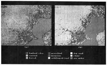
Figure 2. Classified images using a) the maximum-likelihood classifier (MLC) and b) the designed artificial neural network (ANN).
Reference
- ALEXENDER, I. and H. MORTEN.1990. An Introduction to neural computing. Chapman and Hall, London. 237 pp.
- BANDIBAS. JC.1996. The automated land evaluation using artificial neural network based expert's knowledge, GIS and remotely data. Spatial and spectral signatures for satellite image classification. Ph.D. Thesis. Geological Institute, University Gent, Belgium.201 pp.
- HOMOSURA, T. and P.K.M.N.PALEWATTA 1994.Remote sensing techniques for land cover change detection. Proceeding, International Symposium on Operationalization of Remote Seining. ITC Enschede, the Netherlands April 19-23, 1994,Vol, 4: 81-90.
- KHOTANZAD,A and J.LU. 1991 Shape and texture recognition by a neural network. In: artificial Neural Network and Statistical Pattern Recognition. I.K. Sethi, and A,K, Jain, eds. North -Holland ,Amsterdam, Landon, New york, Takyo, pp109-131.
- LILESAND, T.M. and R.W. KIEFER. 1987. Remote sensing and Image Interpretation.John Wiley & Sons Ind. New York. 721 pp. MING, Z., Z.F. BO, T. YONGHONG AND L. DAELS. 1994. Classification of satellite image and GIS data using artificial neural network: A case study. Presented on the workshop on the requirements for geographic information system, New Orleans, Louishiana, February 2, 1994.
- SHOSHANAY, M. and I.D GUEDALIA. 1994. The application of artificial neural network for mapping vegetation. Proceeding Int. Symp. On Operationalization of Remote Sensing, ITC Enschede. The Netherland. April 19-23. 1994. 6:45-51.
- RUMELHART, D.E., G.E. HINTRON and R.J. WILLIAMS. 1996. Learning Internal Representations by Error Propagation in Parallel Distributed Processing. MIT press, Massachusetts. Vol. 1 and 2.