| GISdevelopment.net ---> AARS ---> ACRS 1998 ---> Agriculture/Soil |
Using an EM Model in Remote
Sensing of Soil Surface from Polarimetric SAR
K.S.Chen1,
M.K.Tsay2 and T.D .Wu2
1Center for Space and Remote Sensing Research
2 Department of Electrical Engineering
National Central University
Chung - li, Taiwan
E-mail : dkschen@csrsr.ncu.edu.tw
Abstract1Center for Space and Remote Sensing Research
2 Department of Electrical Engineering
National Central University
Chung - li, Taiwan
E-mail : dkschen@csrsr.ncu.edu.tw
In this paper, we apply an em model to retrieve the soil surface parameters from the polarimetric SAR imagery data . Treating the soil surface as a dielectric layer of finite depth, followed by calculation of reflection coefficients from such layer , the IEM model was used to account for the presence of layer medium representing the soil dielectric profile . Model bebavior was numerically illustrated as function of roughness, moisture content, and a dielectric change rate . Result, when compared with available ground truth shows that the presented approach gives fairly good agreement. The only free parameter, the dielectric change rate , yet remains to be further determined experimentally .
Introduction
Soil surface information is the most important factors related to our environmental change . Much efforts have been devoted to better estimation of moisture content by means of remote sensing. As high spatial resolution is required, synthetic aperture radar (SAR) might be a suitable candidate.The complexity of wave-target process, however ,imposes some restrictions when dealing with the parameters retrieval from acquired SAR data . For example, within an imaging resolution cell, the total return composes of many different sources being observed these contributions differ in their different behavior of wave propagation and scattering and some of them are the dominant ones depending on radar wavelengths and other factors. The random wave traveling path within resolution cell inherently produces speckle noise making the measurement uncertainty even larger. Then the inverse mapping is highly nonlinear and analytic function usually does not exit. As the searching of better solution continues, this paper proposed an effective method. A practical soil scattering model based on the framework of IEM model is developed. The model is then used to generate a set of well-controlled Synthetic data for later training data. A target decomposition was applied to preprocess the SAR data acquired during SIR-C mission the soil extract the soil surface contribution. Finally, a neural network trained by Kalman filtering technique was served as inverse mapper. The test data is a set of SIR-C polarimetric SAR imagery data over Washita , Oklahoma USA. It was demonstrated that the proposed technique gives a better agreement between inverted data and ground truth.
EM Scattering from An inhomohenous soil surface
Most of the theoretical models treat the soil surface as a homogenous half- space. This usually is not so. For example , soil surfaces dry up from the top down after rain forming a dielectric profile in which the permittivity varies in depth. This it is desirable to incorporate a physical Dielectric gradient into our theoretical modeling . The necessary step to extend the IEM model ( fung et al ,1992,chen et al , 1995 )to incorporate a vertical soil moisture profile to replace the standard reflection coefficients by a layered reflection coefficients. Consider the transitional dielectric layer given by (Brekhovskikh , 1980)in which the pemittivity as function of depth, z,is
| e(z) = 1 + er1 | exp(mz) ---------------- 1 + exp(mz) |
(1) |
In the formulation of Brekhovskikh, note that e r1=er¥-1, and - N =e r1. The inputs to the model are the transition rate factor m and the dielectric constant at =¥ whichis e¥.The real part of the dielectric will always start at-¥= which is air and gradually change to e ¥ at rate of m. The Fresnel reflection coefficient are given by.
To begin with the model simulation , we first show the dependence of backscattering coefficient on m, the change rate , The value of m clearly depends on the soil type , among other. At normal incidence, there is polarization dependence , i.e,s°hh¹s°vv. There is a cross- over at incidence angle of 60 degrees for the case of m=10 and m=100. Fig 1 illustrates the dependence of backscattering coefficient on m.
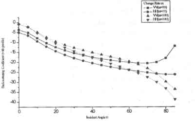
Fig.1 Dependence of the backscattering coefficient on m
Retrieval Scheme
The use of any retrieval algorithm s a good set of measured data upon which to validate the accuracy signal model can be in one of many forms including empirical algorithms or a closed -form model such as the IEM. To date , a significant problem has been that there is a severe dearth of measurements with a complete set of consistent ground truth . In many existing sets encountered , the ground truth does not contain a soil moisture profile as required in our model . However , its need can be demonstrated using a set if Washita data , where measurements were acquired over a period of time after rain.
Decomposition of SAR return
As a preprocess step , we shall apply a target decomposition theorem to decompose a SAR total return signal which contains contribution from many sources - among them only return from ground are directly related to soil moisture. Therefore , it will be proven to be useful to single out the ground scattering term for purpose of retrieval. We include here the explicit expressions for completeness.
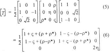
The eigenvector - based decomposition proposed by Cloude [1996] will be used in this paper. We can write the reflection symmetric convariance matrix as follows

The coherence matrix is then of the form.
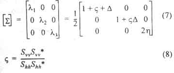
The eigenvalue of coherence matrix [T] can be calculated as
| r = | ShhSvv* ------------- ShhShh |
(9) |
hShvShv* (10)
It is easy and straightforward to obtain (8)-(10) from muller matrix. Once the eigenvector is obtained,the total scattering return can then be decomposed.
Retrieval Procedure
The use of neural network as an inverter of remote sensing parameters has been documented [T sang et al., 1993; Tzeng et al, 1994; Chen et al, 1995; Chen et al, 1998]. Its effectiveness and usefulness has been demonstrated from a wide range of parameters acquired by different sensors. This study apply a dynamic learning neural network to perform the soil surface parameters inversion from the backscattering coefficient estimated from the SAR acquisitions from SIR-C mission.
Inversion results and discussions
The test area was located at Little Washita river watershed, southern of Chickasha, Okhaloma. The area covering approximately 610 square kilometers, is wet and damp in its weather with annual rain rate about 750 mm mostly fallen in spring and fall season. The terrain in mild sloping, the height relief is no more than 150 meters, except a stone mountainous at the north-east region; therefore, it is very suitable for testing the surface parameters inversion from SAR observations. SAR data set was acquire by a L-band (f=1.254 GHz)SAR system during NASA SIR-C/X-SAR mission in 1994. it was a multi-temporal campaign consistent with ground based scatterometer. During the mission , extensive ground truth collection was conducted. Table 1 list some important parameters in certain area.
The inversion results using different models to train the neural network were given in Table 2. in comparison with limited available ground truth data, it was found that the regular IEM can invert most of the data points, but all are wrong results, despite of its combined with TD. We observe that the inversion results using the dielectric profile agree well with the ground truth. This is particularly true where the TD was combined. For the moment, we may conclude that the dielectric profile simulates very closely the practical situation of the soil moisture content. It is noted that the relationship between the dielectric constant and moisture content can be found in [Hallikainen et al., 1985]. When such profile was adopted, the modified Fresnel reflection coefficient were able to obtain and subsequently cast into the regular IEM model. The only parameter remain to select is the dielectric change rate. Further determination of it should be carried out experimentally.
| Vegtation biomass samples | ||||||
| Test site | cover | date | Averge(g/cc) | Water Content (g/m2) | Height Std. Dev.(cm) | Correl.Length (cm) |
| 11 | Alfalfa | 40694 | 1.36 | 1798 | 0.81 | 11.26 |
| 12 | Baresoil | 40594 | 1.05 | 3.43 | 13.03 | |
| 13 | Winter wheat | 40694 | 1.42 | 1386 | 0.81 | 6.05 |
| 13 | Winter wheat | 2104 | ||||
| 14 | Range | 40694 | 1.01 | 96 | 0.73 | 8.77 |
| 15 | Spring oaks | 41494 | 1.20 | |||
| 21 | Range | 40494 | 1.14 | 78 | 0.87 | 10.62 |
| 22 | Range | 40994 | 1.24 | 107 | 0.67 | 10.98 |
| 23 | Range | 40794 | 1.36 | 65 | 1.31 | 12.89 |
| Site | Correlation Length(cm) | Height stdDev.(cm) | Dielectric constant(real part, imagery part) | |
| 11 | 8.081 | 1.569 | 17.743 | 1.760 |
| 12 | 8.210 | 1.451 | 16.091 | 1.620 |
| 13 | 7.944 | 1.523 | 15.373 | 1.554 |
| 14 | 7.841 | 1.512 | 17.731 | 1.754 |
| 15 | 9.631 | 1.443 | 19.026 | 1.869 |
| 21 | 7.323 | 1.405 | 15.174 | 1.524 |
| 22 | 8.972 | 1.443 | 18.899 | 1.851 |
| 23 | 7.730 | 1.523 | 17.880 | 1.760 |
Conclusion
A soil scattering model based on the IEM model was proposed in an effort to better estimation of soil surface parameters- primary roughness scales and moisture content .This was done by simply replacing the standard reflection coefficients by a layer medium reflection coefficient under the framework of IEM . Model simulation were done to illustrate the difference. An eigenvector - based target decomposition theorem was applied to SAR imagery data to extract those direct soil surface scattering terms .The resulting data were then fed in to a neural net work trained by the soil scattering model to start the parameter in versions. Resulting using the SIR-C data show that the proposed model gives the best etimate among the method . Conclusion can be made that the proposed model can explain more closely the observed data and hence give the best inversion result. The only free parameter left is the change rate, m which need to be further studied.
Reference :
- A.K. Fung, Z. Li, and K.S. Chen. "Backscattering from a randomly rough dielectric surface, "IEEE Trans. Geosci. Remote Sensing, vol. 30, pp. 356-369, 1992.
- K.S.Chen, S.K. Yen, and W.P. Huang, "A Simple Model for Retrieving Bare Soil Moisture from Radar-Scattering Coefficients", Remote Sens. Environ., vol. 54, pp. 121-126, May. 1995.
- L.M. Brekhovshikh, Waves in Layered Media, ACADEMIC PRE-SS, 1980. M.T. Hallikainen, F.T. Ulaby, M.C. Dobson, M.A. El-rayes, and Lin-Kun Wu, "Micro-wave Dielectric Behavior of Wet Soil -Part 1 : Empirical Models and Experimnetal observations", IEEE Trans. Geosci, Remote Sensing, vol GE-23, NO. 1, PP. 25-34, Jan. 1985.
- S.R. Clude and E. Pottier, " A Review of Target Decomposition Theorems in Radar Polarimetry", IEEE Trans. Geosci, Remote Sensinsing, vol. 34, no. 2 pp. 498-518, Mar. 1996.
- L. Tsang, Z. Chen, S. Oh, R.J. Mark II, and A.T.C. Chang, "Inversion of snow parameters from passive microwave remote sensing measurements by a neural network trained with a multiple scattering mode, "IEEE Trans. Geosci. Remote Sensing, vol. 30 pp. 1015-1224, 1992.
- Y.C. Tzeng, K.S. Chen, W.L. Kaso, and A.K. Fung, "A Dynamic Learning Neural Network for Remote Sensing Applications "IEEE Trans. Geosci. Remote Sensing, vol. 32, no. 5, pp. 1096-1101, Sep. 1994.
- KS. Chen, W.L. Kaso, and Y.C. Tzeng, "Retrieval of surface parameters using dynamic learning neural network, "Int. J. Remote Sensing, vol. 16 no. 5, pp. 801-808, 1995.
- K.S. Chen. Y.C. Tzeng, and P.T. Chen, "Retrieval of Ocean Winds from Satellite Scatterometer by a Network, "IEEE Trans. Geosci. Remote Sensing, in press 1998.