| GISdevelopment.net ---> AARS ---> ACRS 1998 ---> Agriculture/Soil |
Estimation of Agricultural
Productivity Distribution in India
Yujiro Hirano, Shiro Ochi and Ryosuke Shibasaki
Institute of Industrial Science, University of Tokyo
7-22-1 Roppongi, Minato-ku, Japan, 106-8558
Tel: (81)-3-3402-6231 Fax: (81)-3-3408-8268
E-mail: hirano@skl.iis.u-tokyo.ac.up
Yujiro Hirano, Shiro Ochi and Ryosuke Shibasaki
Institute of Industrial Science, University of Tokyo
7-22-1 Roppongi, Minato-ku, Japan, 106-8558
Tel: (81)-3-3402-6231 Fax: (81)-3-3408-8268
E-mail: hirano@skl.iis.u-tokyo.ac.up
Abstract
Improvement in agricultural productivity has become a necessity due to the limitation in expansion of cultivated acreage and ever increasing food demand. To forecast the growth of agricultural productivity, crop production data aggregated by administrative zone such as states and nations along are not sufficient because it is necessary to take into account environmental and land conditions specific to each location. With this background, this paper discusses a method to estimate the distribution of agricultural productivity as case study of India. The distribution of NPP for each grid cell (8km resolution) was estimated using the NDVI data derived from NOAA AVHRR and PAR. NPP in crop land was extracted using the land use data and has been summed up by each districts. Correlation of the agricultural productivity and NPP were investigated by comparing statistical crop production data on each district. As the result, it was found estimated from remote sensing data is effective to complement data of crop production. Finally the grid-level agricultural productivity was estimated using NPP data.
Introduction
Food demand is foreseen to continue increasing along with the increase in the world population. However, an expansion of cultivated acreage can not be expected because of the limitations arising from environment conservation, especially, forest conservation. Therefore, an improvement in farm productivity has become a necessary for coming days.
The growth of the agricultural productivity depends on the land conditions, for example availability of irrigation water resources, soil deterioration, in addition to an improvement of agricultural technology. Mechanization is also influenced by the topography. Whereas, increase in productivity by applying fertilizer are limited due to their side effect of environmental loading. Like this, to foreseen the growth of the agricultural productivity, various environmental factors must be considered, and grasping on detailed space distribution of the crop production becomes indispensable. Moreover, monitoring of the farming area in cultivating stage is effective, because the amount of harvest is insufficient. So remote sensing technology can be very effective for spatio-temporal supplementation.
The purpose of this study is to develop a basic method to estimate distribution of the agricultural productivity using remote sensing data, gives an approach to a fundamental research. India has been selected as study area, because the ratio of the crop land is relatively higher and availability of statistical data. To do this, NPP distribution (8km resolution grid cell) was estimated using NDVI of NOAA AVHRR and PAR data derived from TOMS data set. Next, NPP on crop land (named "crop land NPP") was extracted using the land use data, and totaled in each district. The distribution of the agricultural productivity was estimated, by corresponding with crop land NPP and the statistical data of crop production.
Estimation of NPP distribution using NDVI
NPP distribution was estimated with a method proposed by Hirakoba (1998) based on Production Efficiency Approach. NPP is estimated from solar radiation, absorbed by a plant, and the efficiency index (e) which is the ratio of radiation energy changed into the organic substances.
The radiation energy in wavelength which a plant can use for the photosynthesis is called PAR (Photosynthetically Active Radiation) and data set of PAR was made using the data on TOMS (Dye, 1993). The ratio of PAR absorbed by the canopy of the plant is named fapar (the fraction of PAR), and has been estimated using NDVI of NOAA AVHRR. Solar radiation absorbed by a plant is named APAR (Absorbed PAR) and have been calculated by multiplying PAR and fapar . Therefore, APAR can be calculated from the data set of PAR and NDVI.
In this study, using 8km resolution monthly NDVI data derived from NOAA AVHRR data (figure 1), APAR was estimated. Moreover, monthly NPP was estimated using APAR multiplied by efficiency index (e) which was assumed 1.5 g/MJ, and annual accumulation value was calculated. The NPP distribution estimated in this study is shown in figure 2. Crop land NPP was extracted from NPP distribution using the land use data (figure 3).
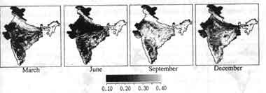
Figure 1: Monthly NDVI (example of March, June, September, December)
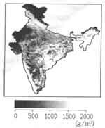
Figure 2: NPP distribution (annual, 1990)
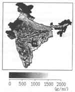
Figure 3: Crop land NPP distribution
NDVI data for the year 1990 was used to match with the statistical data. PAR data available with us was only for the year 1979-1989, therefore monthly mean value of PAR data in this period was calculated and used.
Investigating correlation between agricultural productivity and NPP
The total amount of the organic substance, produced in the crop land, was estimated by multiplying crop land NPP (as describe in proceeding section) and the area under each grid cell. Moreover, verification was tried by calculating them in each district boundary and their correspondence was made with statistical data of crop production. But, in reality is not possible because, crop land NPP is total amount of all crop types whereas statistical data available are on crop basis. Also, the rates of NPP produced in crop land changed into the crop were different by their types. Therefore, it is inappropriate to calculate the total amount of crop production of all crop types. Hence, districts were classified into respective agriculture areas, they were examined for each agricultural land. Rice, maize, wheat, jowar, bajra were selected as object and as they are the major crops in India. The classification into agricultural area was done by selecting the crop planted as shown in the figure 5 and correlation coefficient of crop land NPP and the amount of crop production is shown in the table 1. But, to get rid of the correlation which occur from the difference in the area of each district, they production per planted area and crop land NPP per area of crop land were calculated and used for the purpose. The significance of difference crop types can be seen from table 1 and figure 5. Actually, many crops are produced in each district, so the mixture of other crops in each agriculture area are the reason for errors occurred. So taking the factors into consideration while calculation, it can be said that results obtained are significant and has got relevancy. Therefore, this results says that NPP estimated from remote sensing data can be used to estimate or complement crop production to a large extent.
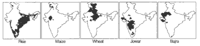
Figure 4. Classification of agriculture area based on planted area
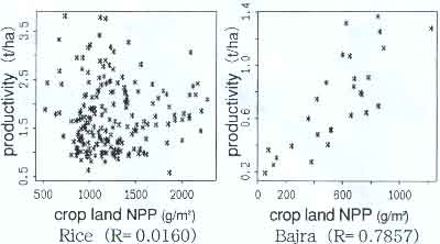
Figure 5: The scatter diagram of crop land NPP and the amount of crop productivity
Table 1. correlation coefficient of crop land NPP and the
amount of crop production
Estimation of agricultural productivity distribution
The distribution of the agricultural productivity was estimated using above examination result. This is shown in figure 6. These were calculated using the agricultural land NPP to complement data available on crop production of each district.
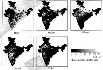
Figure 6. Agricultural productivity distribution
These spatial distribution of the agricultural productivity are open to evaluate the limitation of the environmental conditions and can also be used to examine the potential production of crop land by overlaying other geographical data such as climate and hydrology. Moreover, this research gave the possibility that is can be applied to the prediction of the damage in the disaster mitigation and so on.
Conclusions
In this study, the distribution of the agriculture productivity in India was estimated using remote sensing. The conclusions are as follows.
Acknowledgement
Authors take this opportunity to thank Mr. Hirakoba who graduated from University of Tokyo for providing data, his computer program and his valuable suggestions.
This research is founded by "Research for the future" program of Japan Society for Promotion of Science.
References
Improvement in agricultural productivity has become a necessity due to the limitation in expansion of cultivated acreage and ever increasing food demand. To forecast the growth of agricultural productivity, crop production data aggregated by administrative zone such as states and nations along are not sufficient because it is necessary to take into account environmental and land conditions specific to each location. With this background, this paper discusses a method to estimate the distribution of agricultural productivity as case study of India. The distribution of NPP for each grid cell (8km resolution) was estimated using the NDVI data derived from NOAA AVHRR and PAR. NPP in crop land was extracted using the land use data and has been summed up by each districts. Correlation of the agricultural productivity and NPP were investigated by comparing statistical crop production data on each district. As the result, it was found estimated from remote sensing data is effective to complement data of crop production. Finally the grid-level agricultural productivity was estimated using NPP data.
Introduction
Food demand is foreseen to continue increasing along with the increase in the world population. However, an expansion of cultivated acreage can not be expected because of the limitations arising from environment conservation, especially, forest conservation. Therefore, an improvement in farm productivity has become a necessary for coming days.
The growth of the agricultural productivity depends on the land conditions, for example availability of irrigation water resources, soil deterioration, in addition to an improvement of agricultural technology. Mechanization is also influenced by the topography. Whereas, increase in productivity by applying fertilizer are limited due to their side effect of environmental loading. Like this, to foreseen the growth of the agricultural productivity, various environmental factors must be considered, and grasping on detailed space distribution of the crop production becomes indispensable. Moreover, monitoring of the farming area in cultivating stage is effective, because the amount of harvest is insufficient. So remote sensing technology can be very effective for spatio-temporal supplementation.
The purpose of this study is to develop a basic method to estimate distribution of the agricultural productivity using remote sensing data, gives an approach to a fundamental research. India has been selected as study area, because the ratio of the crop land is relatively higher and availability of statistical data. To do this, NPP distribution (8km resolution grid cell) was estimated using NDVI of NOAA AVHRR and PAR data derived from TOMS data set. Next, NPP on crop land (named "crop land NPP") was extracted using the land use data, and totaled in each district. The distribution of the agricultural productivity was estimated, by corresponding with crop land NPP and the statistical data of crop production.
Estimation of NPP distribution using NDVI
NPP distribution was estimated with a method proposed by Hirakoba (1998) based on Production Efficiency Approach. NPP is estimated from solar radiation, absorbed by a plant, and the efficiency index (e) which is the ratio of radiation energy changed into the organic substances.
The radiation energy in wavelength which a plant can use for the photosynthesis is called PAR (Photosynthetically Active Radiation) and data set of PAR was made using the data on TOMS (Dye, 1993). The ratio of PAR absorbed by the canopy of the plant is named fapar (the fraction of PAR), and has been estimated using NDVI of NOAA AVHRR. Solar radiation absorbed by a plant is named APAR (Absorbed PAR) and have been calculated by multiplying PAR and fapar . Therefore, APAR can be calculated from the data set of PAR and NDVI.
In this study, using 8km resolution monthly NDVI data derived from NOAA AVHRR data (figure 1), APAR was estimated. Moreover, monthly NPP was estimated using APAR multiplied by efficiency index (e) which was assumed 1.5 g/MJ, and annual accumulation value was calculated. The NPP distribution estimated in this study is shown in figure 2. Crop land NPP was extracted from NPP distribution using the land use data (figure 3).
Figure 1: Monthly NDVI (example of March, June, September, December)
Figure 2: NPP distribution (annual, 1990)
Figure 3: Crop land NPP distribution
NDVI data for the year 1990 was used to match with the statistical data. PAR data available with us was only for the year 1979-1989, therefore monthly mean value of PAR data in this period was calculated and used.
Investigating correlation between agricultural productivity and NPP
The total amount of the organic substance, produced in the crop land, was estimated by multiplying crop land NPP (as describe in proceeding section) and the area under each grid cell. Moreover, verification was tried by calculating them in each district boundary and their correspondence was made with statistical data of crop production. But, in reality is not possible because, crop land NPP is total amount of all crop types whereas statistical data available are on crop basis. Also, the rates of NPP produced in crop land changed into the crop were different by their types. Therefore, it is inappropriate to calculate the total amount of crop production of all crop types. Hence, districts were classified into respective agriculture areas, they were examined for each agricultural land. Rice, maize, wheat, jowar, bajra were selected as object and as they are the major crops in India. The classification into agricultural area was done by selecting the crop planted as shown in the figure 5 and correlation coefficient of crop land NPP and the amount of crop production is shown in the table 1. But, to get rid of the correlation which occur from the difference in the area of each district, they production per planted area and crop land NPP per area of crop land were calculated and used for the purpose. The significance of difference crop types can be seen from table 1 and figure 5. Actually, many crops are produced in each district, so the mixture of other crops in each agriculture area are the reason for errors occurred. So taking the factors into consideration while calculation, it can be said that results obtained are significant and has got relevancy. Therefore, this results says that NPP estimated from remote sensing data can be used to estimate or complement crop production to a large extent.
Figure 4. Classification of agriculture area based on planted area
Figure 5: The scatter diagram of crop land NPP and the amount of crop productivity
| Rice | R=0.0160 |
| Maize | R=0.4801* |
| Wheat | R=0.2748** |
| Jowar | R=0.5451** |
| Bajra | R=0.7857 |
| **...Significance level
1% *...Significance level 5% | |
Estimation of agricultural productivity distribution
The distribution of the agricultural productivity was estimated using above examination result. This is shown in figure 6. These were calculated using the agricultural land NPP to complement data available on crop production of each district.
Figure 6. Agricultural productivity distribution
These spatial distribution of the agricultural productivity are open to evaluate the limitation of the environmental conditions and can also be used to examine the potential production of crop land by overlaying other geographical data such as climate and hydrology. Moreover, this research gave the possibility that is can be applied to the prediction of the damage in the disaster mitigation and so on.
Conclusions
In this study, the distribution of the agriculture productivity in India was estimated using remote sensing. The conclusions are as follows.
- NPP distribution and crop and NPP distribution in India were estimated by Production Efficiency Approach using remote sensing data.
- The correlation of the agricultural productivity and NPP is investigated and it was found that NPP estimated from remote sensing data is effective to complement data of crop production.
- The distribution of the agricultural productivity was estimated using NPP derived from remote sensing data and the statistical data of crop production.
Acknowledgement
Authors take this opportunity to thank Mr. Hirakoba who graduated from University of Tokyo for providing data, his computer program and his valuable suggestions.
This research is founded by "Research for the future" program of Japan Society for Promotion of Science.
References
- Atushi HIRAKOBA (1998) : Estimation of Agricultural Productivity using satellite data, master's thesis (University of Tokyo).
- Dye, D.G. Goward, S. and Eck, T.F., (1993): Global Solar Radiation Data Set for Global Primary Production Studies, Proceedings of SEIKEN SYMPOSIUM, 12 Global Environment Monitoring from space, pp. 258-262.