| GISdevelopment.net ---> AARS ---> ACRS 1997 ---> Water Resources |
Soil Erosion and Hydrological
Study of the Bakun Dam Catchment Area, Sarawak Using Remote Sensing and
Geographic Information System (GIS)
Roslinah Samad, Norizan
Abdul Patah
Malaysian Centre For remote Sensing (MACRES),
P.P. Box 208, Lot CB 100,
5th Floor, City Square Centree,
Jalan Tun Razak, 50400 Kuala Lumpur, Malaysia.
Tel: 603-2645640, Fax: 6032645650,
E-mail : ipa@macres.gov.my
Abstract Malaysian Centre For remote Sensing (MACRES),
P.P. Box 208, Lot CB 100,
5th Floor, City Square Centree,
Jalan Tun Razak, 50400 Kuala Lumpur, Malaysia.
Tel: 603-2645640, Fax: 6032645650,
E-mail : ipa@macres.gov.my
The Universal Soil Loss equation (USLE) was applied to predict annual soil loss in the study area, using the integration of satellite remote sensing and Geographic Information System (GIS) technologies. Parameters of the USLE used to generate the relevant raster layers for soil erosion spatial modeling in the GIS are - (i) rainfall erosivity, (ii) slope length/gradient, (iii) cover- conservation method and (iv) soil erodibility. The analysis was done in MICSIS (Micro-computer spatial Information system), an image processing and GIS software package developed specifically for erosion modeling under the Malaysian-China coorperation, In the hydrological study, a three dimensional (ec) animation package (ed Studio software) was used to computer water inundation extent and storage at three flood levels in the catchment area of the Bakun dam. The current and potential erosion risk maps of the study generated, which will be useful for planning the land clearing activities at Bakun and estimating the severity of soil sedimentation in the dam area. At three predetermined flood levels 233 m, 228 m and 195 m, the extents of inundation, indicating the types of land cover affected, have been located. The extents of inundation the types of land cover affected, have been located. The corresponding water storage volume in the Bakun catchment at the three flood levels were also estimated.
1.0 Introduction
Soil erosion is one of the most serious environmental problem where its remove soils rich in nutrients, increase natural level of sedimentation in the river and cause flash flood at the construction area. Most of the soil erosion study done by other researchers were based on the Universal Soil Loss Equation (USLE) (Wischmeier and Smith, 1978) as a method to predict the soil loss. USLE take into account several factors such as rainfall, soil erodibility, slope, land cover and erosion control practice for soil erosion prediction. In this study, remote sensing date was used to drive land cover/use map for the Bakun catchment area. Malaysia and China embarked on this cooperative project during the period November 1995 -April, 1996. The objectives of the project were to output: (i) the soil erosion risk map of the study area, (ii) a general hydrological model to monitor inundation extent of the study area on a regular basis. However, this study was done to implement a special system for soil erosion modeling in Micro Computer Spatial Information system (MICSIS) which based on the parameter of USLE and also hydrological modeling.
2.0 The Study Area
The Bakun catchment area is located between latitudes 1.5°N and 3.0°N and longitudes 113.5°E and 115.3°E, encompassing Balui River and its tributaries some 37 km upstream of Belaga town.Its covers about 14,750 km2 and its current land use/cover types are primary Forest (74%), selectively logged forest (21%) and shifting cultivation together with grass
Land/bust land (5%). The climate is characterized by an annual precipitation exceeding 4000 mm, mean annual evapotranspiration of about 1300 mm and average temperature of 25°C.
3.0 Materials
landsat TM data (1988 and 1994) with false colour composites band 4,5,3 were used in this study. Reainfall data, soils map and tophographic maps at scale 1 : 25,000 also were used as an ancillary data.
4.0 Methodology
The methodology adopted in the generation of the R,K, LS and C digital raster layers for soil erosion modeling and hydrological studies was done in MICSIS (Micro-computer Spatial Information Special system for soil erosion modeling based on the parameters of the USLE was incorporated in MICSIS.
The Universal Soil Loss Equation (USLE) (Wichmeier and Smit, 1978) is an erosion model designed to predict average soil loss from specific tracks of land under different land use management systems. It computers soil loss as a product of six major factors, whose values are expressed numerically. The USLE is represented by:
Where :-
A - Annual Soil Loss in Kg m-2y-1
R - Rainfall Erosivity
K - Soil Erodibility
L - Slope Length
S - Slope Gradient
C- Land Cover
P - conversation Practice
The USLE was adopted in this study with Minor modifications in estimating the R and K parameters to suit malaysin conditions.
Rainfall Erosivity (R)
Soil loss is related to rainfall through the detachment power of raindrops striking the soil surface and the entrainment of the detached soil particles by run-off water down slope. The R values were computed from the product E. I30 (E- Total kinetic energy of rain, I30 -peak 30 min intensity), which reflects the potential ability of raindraops to cause erosion. E values were computed using the regression equation E = 9.28 P - 88367.15 (Morgan & Davison, 1986) developed to suit Malaysian conditions (P - Mean Annual Precipitation). As I30 values were not available from most rainfall stations located in the study, area, an average I30 value of 75 mmhr-1 was recommended. Mean annual precipitation data were obtained from 16 rainfall stations located in Bakun and its vicinity. The R values for each station were computed using the equation 9.28P-8836.15 *75 and input in the GIS as a discrete point file with location and R value map was generated using the triangulation method of interpolation.
Soil Erodibility (K)
Soil erodibility (K) defines the inherent resistance of the soil to both detachment and transport. The soil map of Sarawak at scale 1:500,000 (1968) was referred. K was determined only from the most predominant soil type in an association. Soil texture, structure, permeability and organic matter content, the parameters that determine the value of K, were obtained from soil profile descriptions, provided by the Department of Agriculture, Sarawak. K values, were estimated from soil erodibility nomograph (Wichmeiser and Smith , 1978) derived from the equation below.
| k=(2.1x10⁻⁴(12-O.M%)(N1xN2)1.14+3.25(S-2)+2.5(P-3))
------------------------------------------------------------------------- 100 |
Where :-
O.M. =Organic Matter Content
N1 = % Silt + % Fine Sand
N2 = %Silt +%Fine Sand +%sand
S =Level of Soil Structure
P = Permeability
A polygon vector file of the soil map was digitized. This was then rasterised and converted into a K value map by reclassing each soil polygon into its corresponding K value.
Topographical Factor (Slope Gradient and Length)
Soil erosion increase with increases in slope gradient (S) and slope length (L) resulting from respective increase in velocity and volume of surface run-off water. LS values were calculated using:
Where :-
L = slope length in m
S = slope gradient in percent
Contour data were extracted from existing topography maps (38 sheets at scale 1:50000) through scanning (32 sheets ) and manual digitization (6 sheets). A DEM was generated from these data and converted to an image file. It was used to generate the slope layer and the slope length.
The Cover Factor (C)
Vegetation cover intercepts raindrops dissipating their kinetic energy before reaching the ground surface. C values were extracted from Morgan & Finney (1982) for cover types found in the area. Four landsat scenes (1988 and 1994) were used to output the land cover layer. Each of the scene was geo-referenced using map control points to conform to the Malaysian Map Projection. Colour balancing was then done on a band basis to reduce radiometric anomalies between adjacent scenes. The four scenes were mosaiked into one image, which encompassed the whole of the Bakun catchment area.
Supervised classification (VI) classifier, was carried out to generate the land cover/use layer. This layer was converted to C layer through reclassification of each cover type into its corresponding C value.
The Conservation Factor (P)
In general the protection offered by crops cultivated on slopes against erosion should be supported by soil conservation practices, which slow down the run-off water. This factor was not accounted in the study area as shifting cultivation commonly conservation practices that did not contribute significantly to erosion protection.
Current Soil Erosion Map
The current soil erosion map was generated. This depicts the extent of soil erosion in the Bakun area in tons/km2/yr, given the present vegetative cover (Figure 1).
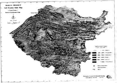
Figure 1. Soil Erosion Risk Map - Present Status
Soil Erosion Risk map
Generation of this map excluded the C layer. It represents a worse case scenario where the soil is depleted of its vegetative cover. It is obvious that the LS factor influences greatly the results depicted (Figure 2).
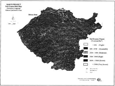
Figure 2. Soil Erosion Risk Map - Selective Logging
Computation of Inundation Extent and Water Volume Using the Digital Elevation Model (DEM) of Bakun, the area coverage of surface inundation (km2) and associated water volume storage (km3) of the Bakun area were estimated at three flood levels designed for the reservoir at Bakun dam - probable maximum flood level (233 m.a.s.l), maximum operational flood level (228 m.a.s.l) and minumum operational flood level (195 m.a.s.l).
5.0 Results and discussion
Soil Erosion Study
Rainfall erosivity of the Bakun catchment area ranges from 880-1400 US units. In the southern part of the cathment area, the erosivity is very high whilst in the vicinity of the dam area is high. Bakun is predominantly characterized by soils of the Skeletal and Red-Yellow Podzolic Group. They are well to excessively drained soils with shallow to moderate depth (25-50 cm of the surface). Their erodibility value of 0.18 is moderate attributed mainly to the high very fine sand and silt content (49%). Soils of high erodibility (>.3) such as the podzols, gely soils, skeletal & podzols, skeletal & gley soils and podzols & gley soils groups occur in very limited extent.
Bakun has a rugged topography with sharp crest and steep slopes. Most of the area is above 500 m a.s.l. with the highest elevation being 2040 m. slope Length varies from 3-10 m for the gentler slopes (2-12) and 10 ³ 20 m for the steeper slope (>12). Except for the logging and shifting cultivation activities in the immediate surroundings of the proposed dam site and also along Balui river towards its headwaters upstream, the catchment area is basically under densed fores cover. Abandoned areas of shifting cultivation have been transitioned into natural bush and grass land over short periods. Current soil loss in tons/km/yr was estimated based on six classess as follows:
| Slight | <200 | (13120km2) |
| Acceptable | 200-2500 | (994 km2) |
| Moderate | 2500-5000 | (80 km2) |
| High | 500-8000 | (79 km2) |
| Severe | 8000-15000 | (127 km2) |
| Very Severe | >15000 | (350 km2) |
Attention should be focused on the logged over forest (including logging tracks) and shifting cultivation areas where no or minimal conservation practice has been employed. Soil loss here ranges from moderate to severe and is estimated to be 6.6 million tons/year. Given the rainfall erosivity, topographical and soil factors the area, the worst case scenario would present a soil loss of some 221 million tons, should the area be completely deplected of vegetation.
Hydrological Study
The extent of inundation at the three proposed flood levels - (i) probable maximum operational flood level 233 m produced 632.44 km2 inundation extent of water and 36.93 km2 volume storage of water' (ii) maximum operational flood level 228 m produced 593.96 km2) inundation extent of water and 33.84 km3 volume storage of water; (iii) minimum operational flood level 195 m produced 388.68 km2 inundation extent of water and 18.42 km3 (Figure 3).
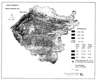
Figure 3. Inundation extent of water at three proposed flood level
6.0 Conclusion
The integration of remote sensing and GIS techniques was successfully employed in this study. MICSIS with its advanced satellite image processing. GIS modelling and expert system modules was used. In the soil erosion study, the USLE was adopted with some modifications to predict the extent and its corresponding water storage volume at three predetermined flood levels. Animation Bakun in 3D prospective at a predetermined flood level was created under 3D Studio environment.
7.0 Reference
- K.F. Loh, Jimat Bolhassan and Nik nasruddin Mahmood (1992). Soil Erosion Mapping Using Remote Sensing and GIS Techniques - Upper Klang Valley, Selangor, Malaysia. Asia-Pacific Remote Sensing Jouranl, July 1992.
- Low, K.S (1987). Integrated Watershed Management in Steep land for Effective Planning and Development: Proceeding of the International Conference Steep Land Agricultural Humid Tropics, Kuala Lumpur, pg. 748-770.
- Morgan, RP.C. (1974). Estimating Regional Variations in Soil Erosion Hazards In Peninsular Malaysia. Malay. Nat. J.28, pg. 94-106.
- Morgan, R.PC., Morgan D.D.V. and Finney, H.J. (1982). Stability of Agricultural Ecosystems: Documentation of A Simple Model for Soil Erosion Assessment. International Institute of Application System Analysis Collaborative paper. Pg.28-50.
- Morgan, R.P.C. (1986). Soil Erosion and Conservation. Longman Group (PE) Ltd., Hong Kong, 295 p.
- Omakupt, M (1989). Soil Erosion Mapping Using Remote Sensing Data And Geographic Information System: Proceedings of the 10th Asian conference of Remote Sensing, Kuala Lumpur, Malaysia.
- Whchmeier, W.H. and Smith, D.D. (1962). Soil Loss Estimation As a Tool In Soil Water Management Planning. International Association of Science Hydrology. Publication 59, pg. 48-59.
- Wischmeier, W.H. and Smith, D.D. (1978). Predicting Rainfall Erosion Losses. A Guide to Conservation Planning. USDA, Agricultural Handbook No. 537.