| GISdevelopment.net ---> AARS ---> ACRS 1997 ---> Poster Session 3 |
Environmental Monitoring of
Coral Reefs in Calatagan, Batangas, Phillippines Using multi-Temporal
Satellite Images
Salvador, J. H.
G.1, Kanbura, H.2., Obara, K.2, Matano,
Y.2, Muraoka, H.3, Almeda, R.1,
Hernandez, S.4 and Panerio,
L.,4
1Mines and Geosciences Bureau, Central Office, Philippines (Fax: 632-928-8544)
2 Nikko Exploration and Development, Co., Ltd., Japan (Fax: 81-3-3508-9785)
3 Earth Remote Sensing Data Analysis Center, Japan (Fax: 81-3-3533-9383)
4 Mines and Geosciences Bureau, Regional Office No. 4, Philippines
Abstract 1Mines and Geosciences Bureau, Central Office, Philippines (Fax: 632-928-8544)
2 Nikko Exploration and Development, Co., Ltd., Japan (Fax: 81-3-3508-9785)
3 Earth Remote Sensing Data Analysis Center, Japan (Fax: 81-3-3533-9383)
4 Mines and Geosciences Bureau, Regional Office No. 4, Philippines
Four Landsat TM images from 1989 to 1996 were acquired to study the coral reefs and adjacent fishpond and mangrove areas in Calatagan, Bantangas.Bottom materials in the reef were classified. The study shows a change from mangrove areas to fishpond areas through the years. Siltation along the coast was observed in the images. There is no noticeable change in the distribution of biological substrate materials in the reef. However, modification in the present land use of the nearby land may affect the present condition.
Introduction
This study is part of the three-year Philippines-Japan cooperative undertaking by the Phillippine Mines and Geosciences Bureau (MGB) under the Department of Environment and Natural Resources (DENR), Nikko Exploration and Development Co., Ltd. (NED) and Earth Remote Sensing Data Analysis Center (ERSDAC), Japan. The main objective is to apply remote sensing technology to the management of the coastal environment and resources in Luzon Island. The current study corresponds to the third phase in the three-years program.
The specific objective of this study includes the application of satellite remote sensing technology and image processing techniques to monitor the distribution of coral reefs, mangroves and pollution of sea water. It also aims to acquire and provide information on the dynamic charges along coastal areas, of shallow sediment distribution, and other relevant geoscientific features. In the end, it is hoped that the results of this study and the techniques developed with contribute to the management of coastal zones.
A. Location and Accessibility of the Study Area
Our Study area, the Calatagan coral reef area is situated at Batangas Peninsula, within the jurisdiction of Calatagan Municipality in Batangas. The peninsula is located south of Manila, the capital city of the Philippines. It is bounded by latitudes 13°45'N to 13°55'N and longitudes 120°35'E to 120°45'E. West of the peninsula is the South China Sea and on the east is Pagaspas Bay. Calatagan is situated in the so-called "growth corridoer sub-region". It can be reached by public utility buses via 120 km of first class road from Manila. A private airport is being maintained one km north of Calatagan town.
B. Climate and Topography
The study area has a type I climate. They dry season generally starts from November and continues to April. The rainy season begins in May and ends in October. The annual average temperature is 27°C. The rainy season is usually accompanied by typhoons and monsoons.
The study area is characterized by rolling and moderately rugged terrain. The highest elevation is less than 300 meters. The low plain areas along the coast and inland are generally narrow and limited in extent.
C. General Geology
Three lithologic units are present in the study are namely, interbeds of tuffaceous sandstones and shale, limestone and alluvium. Outcrops of tuffaceous clastics are flat or gently dipping and sometimes slightly folded. The limestone unconformable overlies the tuffaceous clastics. Alluvium consists of unconsolidated deposits of silt and gravel along valley and coastal plains.
D. Coastal Environment
Coral reefs are well developed on the west coast of Batangas, east coast of the Balayan bay and northwestern part of Maricaban island. Their appearance is very conspicuous in the satellite images (Figs. 1a, 1b, 1c and 1d.).
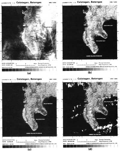
Figure 1: The four Landsat TM images used (bands 1, 2 and 3 in blue, green and red color assignments). (a) December 12, 1989, (b) April, (c) February 19, 1995, and (d) March 25, 1996.
The coral reefs on the west side of Balayan Bay in Calatagan, Batangas is a fringing-type. It is the largest in the area measuring about 8 km in length and 3 km in width. The beach areas consist of coralline sand, mangrove areas, fishpond and prawn ponds. The reef flat consists of coralline sand or muddy bottom, coral communities and seagrass communities. The Thallasia sp. of seagrass is dominant. The reef crest is exposed during the low-tide. The reef slope gradually increases in depth becoming a coral inhabiting zone.
Photo-interpretation on the Landsat TM Color Composite Images
Four sets of Landsat TM false color images (BGR = 1,2,3; scale 1:50,000) acquired different periods (1989, 1993, 1995 and 1996) were used to classify the bottom materials in the Calatagan coral reef area. The geometry was corrected to the UTM coordinates system. The photo-interpretation was based on the tonal difference and distribution patterns on the image. These features were verified in the field (Fig. 2). Figure 3 shows the 12 categories resulting from the classification of bottom materials in the coral reef area. Table 1 gives a brief description of each category.
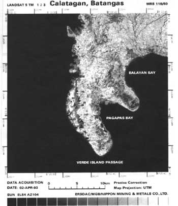
Figure 2: The location map of the Sea Truth Survey Points in the Calatagan Coral Reef Area.
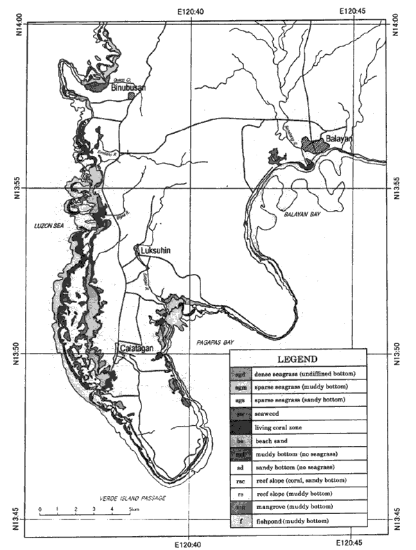
Figure 3: Photo-interpretation Map of the Calatagan Coral Reef Area using Landsat TM False Color Composite Image.
| Category | Description |
| Dense seagrass(bottom materials unknown) | It shows as a dark gray color on the image. It is distributed in front of reef-flats about 100 m from the coast to 250m towards the sea. |
| Sparse seagrass(muddy bottom) | It shows as dark gray t gray, and it distributed near the mangrove areas along the coast, it is sometimes located at the front of the fishponds. |
| Sparse seagrass(sandy bottom) | It shows as dark gray to gray, and is distributed near the sparse seagrass (muddy bottom) but farther out towards the sea. |
| Algae | It shows as gray on the image and is distributed locally in front of reef-flats. Considering its distribution pattern, algae were interpretated to be correlated to the reef crest. |
| Coral | It shows as gray color, and it distributed outside the front of reef-flats in the Luzon Sea, especially the outside the front of reef-flats to the west of Calatagen. |
| Beach sand | It shows as white color, and is distributed near the coast of the Calatagan peninsula. |
| Muddy bottom(no seagrass) | It shows as gray color. It is distributed near the coasts of Pagaspas Bay and Balayan |
| Sandy bottom(no seagrass) | It shows as whitish blue to gray tones. It is observed in the reef-flats. This is essentially coralline sand, Dead corals are frequently observed. |
| Reef slope(living coral, sandy bottom) | It shows as light blue color. It sometimes occurs outside the living coral area. |
| Reef slope(muddy bottom) | It shows as light blue color. It is distributed in the coastal zone of the Pagaspas Bay and Balayan Bay. |
| Mangrove(muddy bottom) | It shows as black to dark green color. It is distributed along the coast of Pagaspas Bay and Balayan Bay. It was also observed near the mouth of Bigaa River. |
| Fish pond(muddy bottom) | It shows as black color on the image. It is distributed on shore near the coast of the peninsula. |
Discussion
The features in the Calatagan coral reef were interpreted using multi-temporal satellite data (1989, 1993, 1995 and 1996). These observed features were verified in the field. The result of the study shows that there is not noticeable change in the substrate or bottom materials as noted from the Landsat TM images. This implies that there is essentially no change in the biological community such as seagrasses and corals. This could mean slow growth of such communities.
However, most of the changes found were the transformation of mangrove areas into fishponds. Siltration and muddy areas are usually observed near mangrove and fishpond areas. In addition, there is an on-going development of a Hawaiian-style seaside holiday resort nearby. Further modification of the land could affect the coral reefs in the area. This makes it necessary to continuously monitor the coastal environment in Calatagan.
Conclusion
The coral reef areas in Calatagan, Batangas were studies using multi-temporal Landsat TM data. The results show that there is essentially no change in the distribution of the biological communities such as seagrasses and coral from 1989 to 1996.
Most of the changes in the area are due to the transformation of mangrove areas to fishponds. Muddy and silted areas are found near mangrove and fishpond area. More changes are expected with the development of a nearby resort and similar or related projects.
References
- BMG, 1987a. Geologic Map of Balayan Quadrangel, Sheet No. 3161 IV.
- BMG, 1987b. Geologic Map of Calatagan Quadrangle, Sheet No. 3161 III.