| GISdevelopment.net ---> AARS ---> ACRS 1997 ---> Poster Session 3 |
Land Use /Land Cover
Classifications and Monitoring of Myanmar Using by Remote Sensing Data and
GIS
Ko Ko Lwin and Ryosuke
Shibasaki
Institute of Industrial Science, University of Tokyo
7-22-1, Roppongi, Minato-Ku Tokyo 106, Japan
Tel : (81)-3-3402-6231 Fax : (81)-3-3479-2762
E-mail : lwin@shunji.iis.u-tokyo.ac.jp
Abstract
Institute of Industrial Science, University of Tokyo
7-22-1, Roppongi, Minato-Ku Tokyo 106, Japan
Tel : (81)-3-3402-6231 Fax : (81)-3-3479-2762
E-mail : lwin@shunji.iis.u-tokyo.ac.jp
Knowledge of land use and land cover is important for many planning and management activities concerned with the surface of the earth. The term land cover relates to the type of feature present on the surface of the earth and the term land use relates to the human activities associated with a specific piece of land. The study of the land use patterns and the monitoring of changes are very important for economic planning and country development. By using of Remote Sensing methods are becoming increasingly in land use land cover studying that is important for images of large area can be acquired rapidly and low cost. In this paper we would like to present study objectives, study overview and study flow diagram.
Study Area
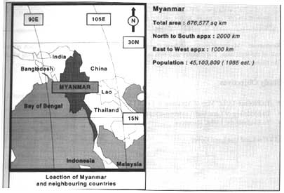
Geography :
Myanmmar lies on the western edge of the Indochina peninsula has an area of 676,577 sq. km, sandwiched between Thailand, Laos to the east and Bangladesh, India to the west and China bordering on the North. The Bay of Bangal and the Andman Sea from the southern boundaries of the country. The Western mountains. The Central lowland, and The Shan Plateau in the main rivers, Ayeyawady, Chindwin, Sittaung and Thanlwin.
Climate:
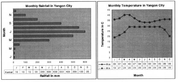
Climate condition varies from place to place, although generally a tropical monsoon climate prevails. There are three seasons cycle : viz. the hot season, the raining season and cool season. The average temperature ranges in most parts of the country between 25°C and 33°C in the raining seasons, 10°C to 25°C in the cool season and between 32°C to 43°C in the hot season. Annual precipitation varies from 500cm in the coastal and delta regions to 75cm and less in the central dry zone.
Resources:
Myanmar possessing huge stands of teak and other hard woods, which covers half of the total area. The country also rich in gems, oil, natural gas and mineral deposits which like timber.
Study Objectives
- To Produce LULC Map of Myanmmar in Level I Scale
- To modeling of Land Use-Environmental Inter Action System
- To Evaluate the LULC resources
Study Overview
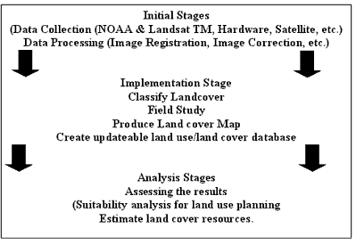
Research Flow Diagram
| Forest Land | Area (sq. km) | Percent |
| Closed Forests | 293,269 | 43.34% |
| Degraded Forests | 50,968 | 7.53% |
| Forests affected by shifting cultivation | 154,389 | 22.82% |
| Water bodies | 13,327 | 2.01% |
| Non-Forest | 164,600 | 24.30% |
| Total | 676,553 | 100.00% |
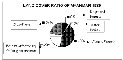
Source : Forest Cover of Myanmar - 1989 Appraisal, F. Dept. [Landsat TM 5 Imagery (1989)
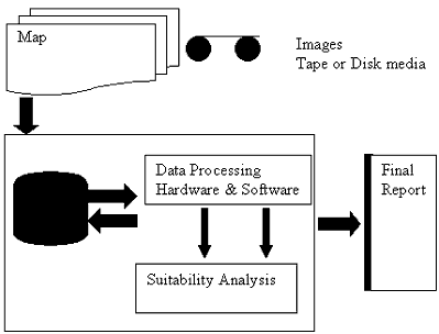
Conclusion
The human society is closely depending on natural resources. On the other hand the earth suffers growth of population, deforestation, depletion of natural resources and these resources are becoming always more scare. The land use land cover classification is one of the basic requirement of monitoring and management of the natural resources which is essential requirement of country planning and development. Satellite remotely sensed data is can be effectively applied for monitoring and classification of land cover land use type by regionalize. These analyzed data are can be handled or retrieved efficiently by GIS (Geographic Information System) tool. Thus, the integration of remote sensor data and GIS are main process of this study.